Halifax County is located in North Carolina’s Piedmont, Coastal Plain, and Atlantic Coast Flatwoods regions. Much of the region’s geography and history were shaped by the Roanoke River, which forms the northern boundary of Halifax County. According to Preservation North Carolina, “Halifax County is one of the oldest counties in North Carolina with a rich history dating back to the earliest days of European settlement of North America. Over the years, Halifax County has provided North Carolina with more leaders – governors, congressmen, generals – than any other county in the state.”
Originally the area was home to Tuscarora Indians before it was settled in the early 18th century by English colonists migrating south from Virginia and also from New Jersey. The town of Halifax developed along the banks of the Roanoke River and established itself as the trading center for goods passing through the area. Halifax remained a prosperous county until the railroads overtook the river as its major form of transport. The town of Halifax became the county seat. (Enfield was the original county seat when Halifax was part of Edgecombe County).
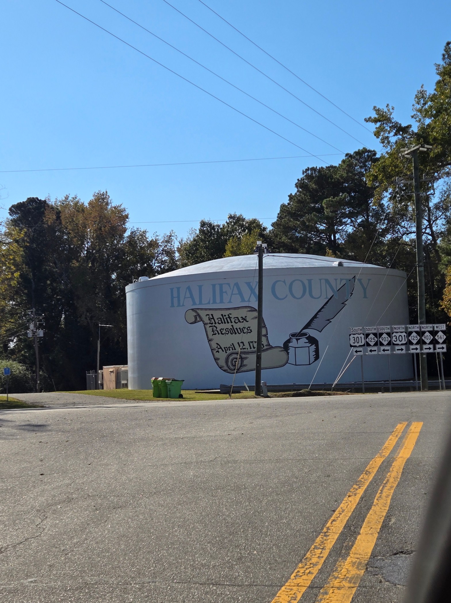
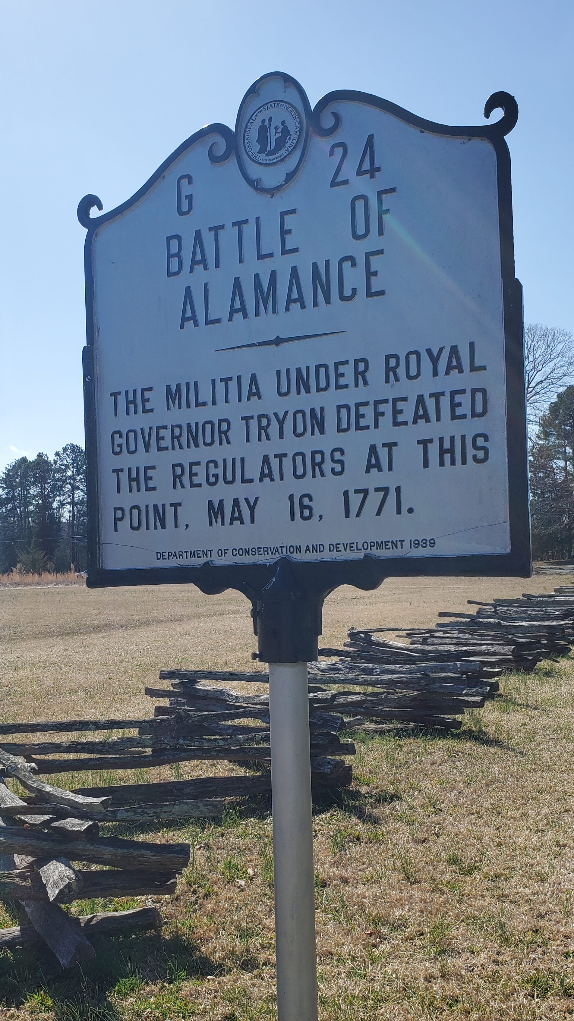
In addition to claiming 40 sites on the National Register of Historic Places, Halifax County is also historically significant for other reasons. On April 12, 1776, the North Carolina Provincial Congress met in Halifax and passed a resolution known as the Halifax Resolves. The first resolution of its kind, the document instructed North Carolina’s delegates to the Second Continental Congress in Philadelphia to vote for independence from Great Britain. The date of the Halifax Resolves is commemorated on the state’s flag. Each year April 12 is celebrated as Halifax Day, with individuals in period costumes demonstrating colonial-era activities and craftsmanship.
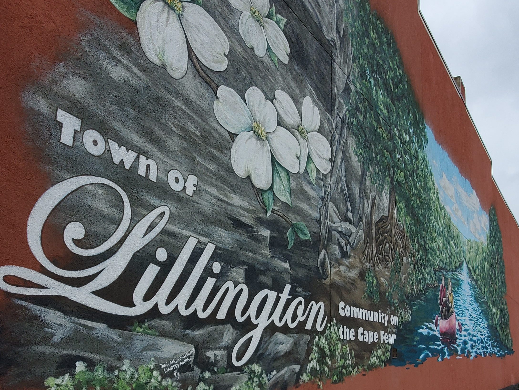
Littleton
Originally Littleton was divided between the counties of Warren and Halifax, but on July 1, 1974, an election was made to make Littleton only to be a part of Halifax County. Incorporated in 1877, the town was named for William Little who was a state senator when the town was founded, and he was also the first Postmaster of Littleton. The original post office was “Person’s Ordinary” and is still standing in its original location on Warren St.
In 1882, Littleton College for women was founded with an initial enrollment of eleven students. The college became relatively successful with a peak enrollment of 285 in 1908. On January 22, 1919, the college was destroyed by fire, and without an endowment, it was never rebuilt.
Littleton has been known as “Little People Town”, and “The Little Town with the Big Heart”, and “Gateway to Beautiful Lake Gaston.” When in Littleton, be sure to stop by Main Street Mercantile for some lovely gifts and locally crafted items.
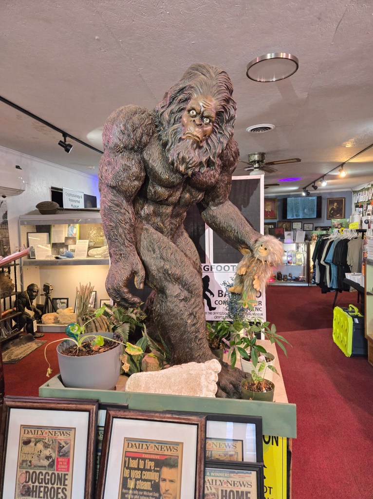
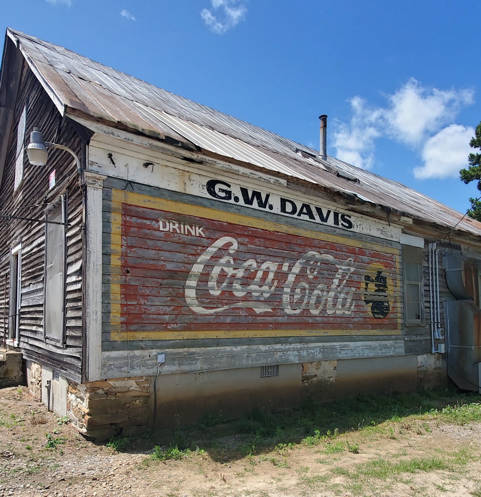
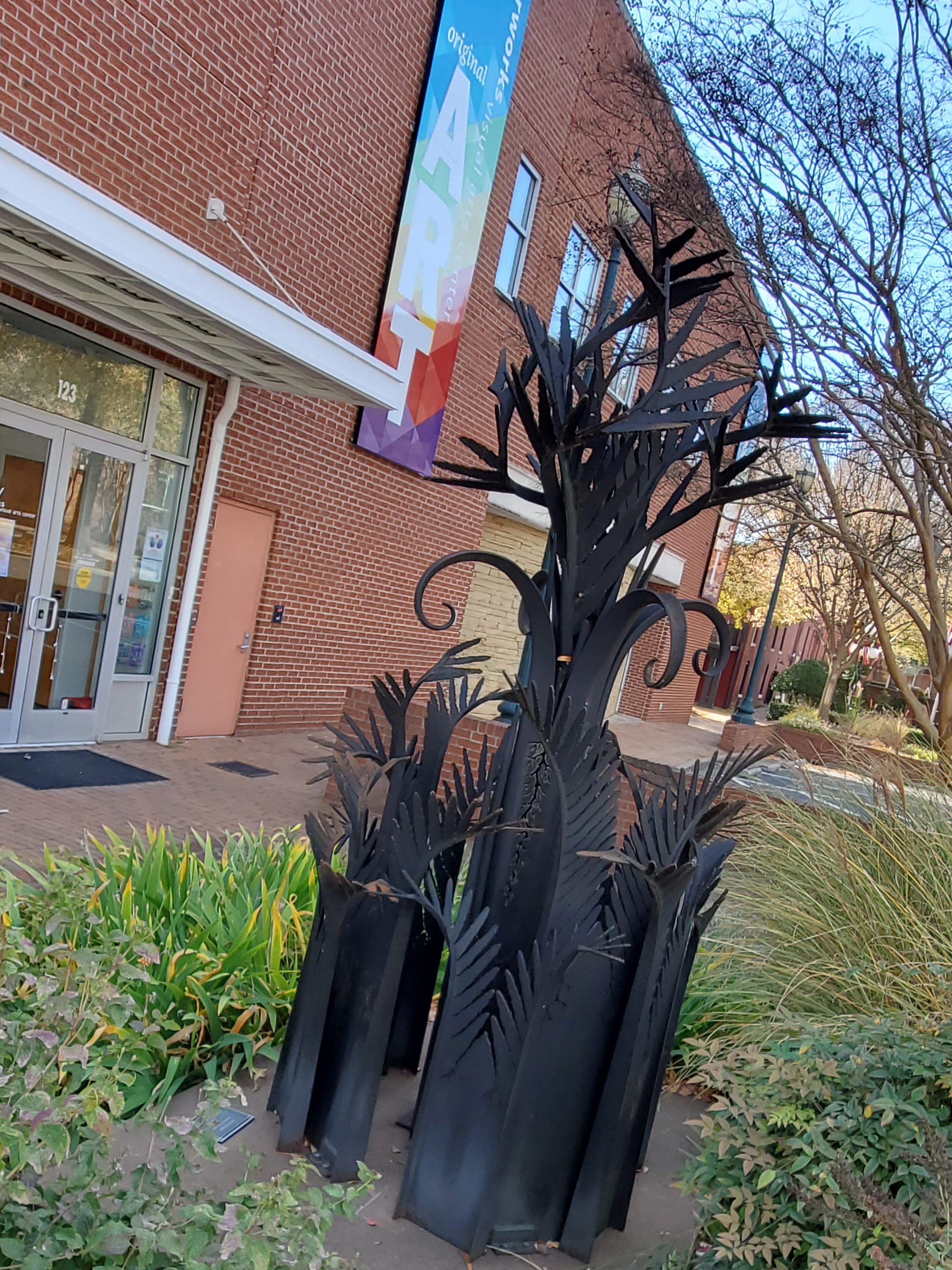
The Cryptozoology & Paranormal Museum Just down the street from the town’s center, you’ll discover the Cryptozoology & Paranormal Museum (300 N Main St.). The museum holds several dolls purported to be haunted as well as several authentic Big Foot foot castings and numerous other objects and collections of haunted items, paraphernalia, and historic cryptid items. The museum is run by Stephen Barcelo, who has been interviewed by paranormal shows numerous times. The museum director promises that you won’t walk away with any attachments, although the museum itself has had some unexplained phenomena.
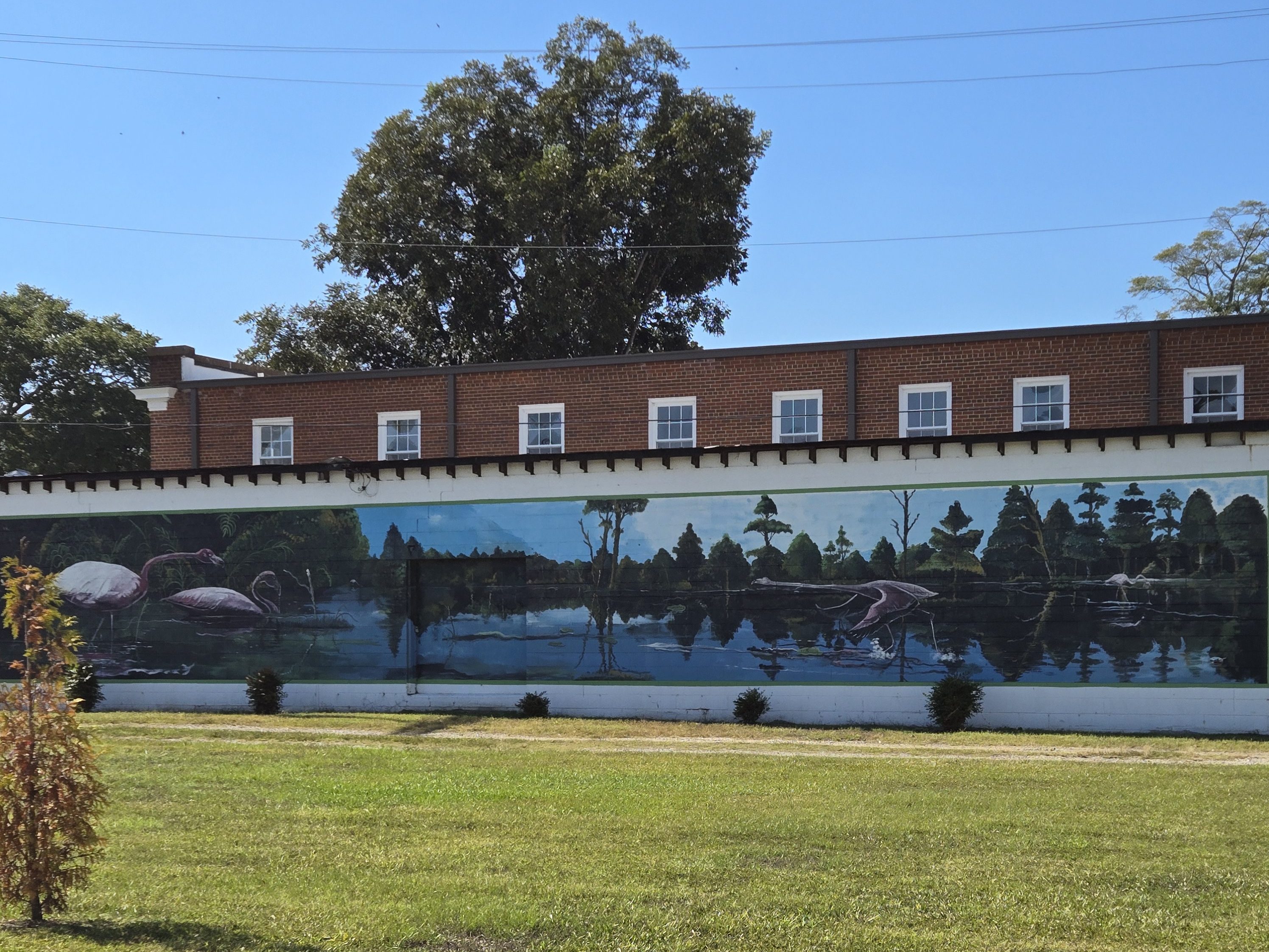
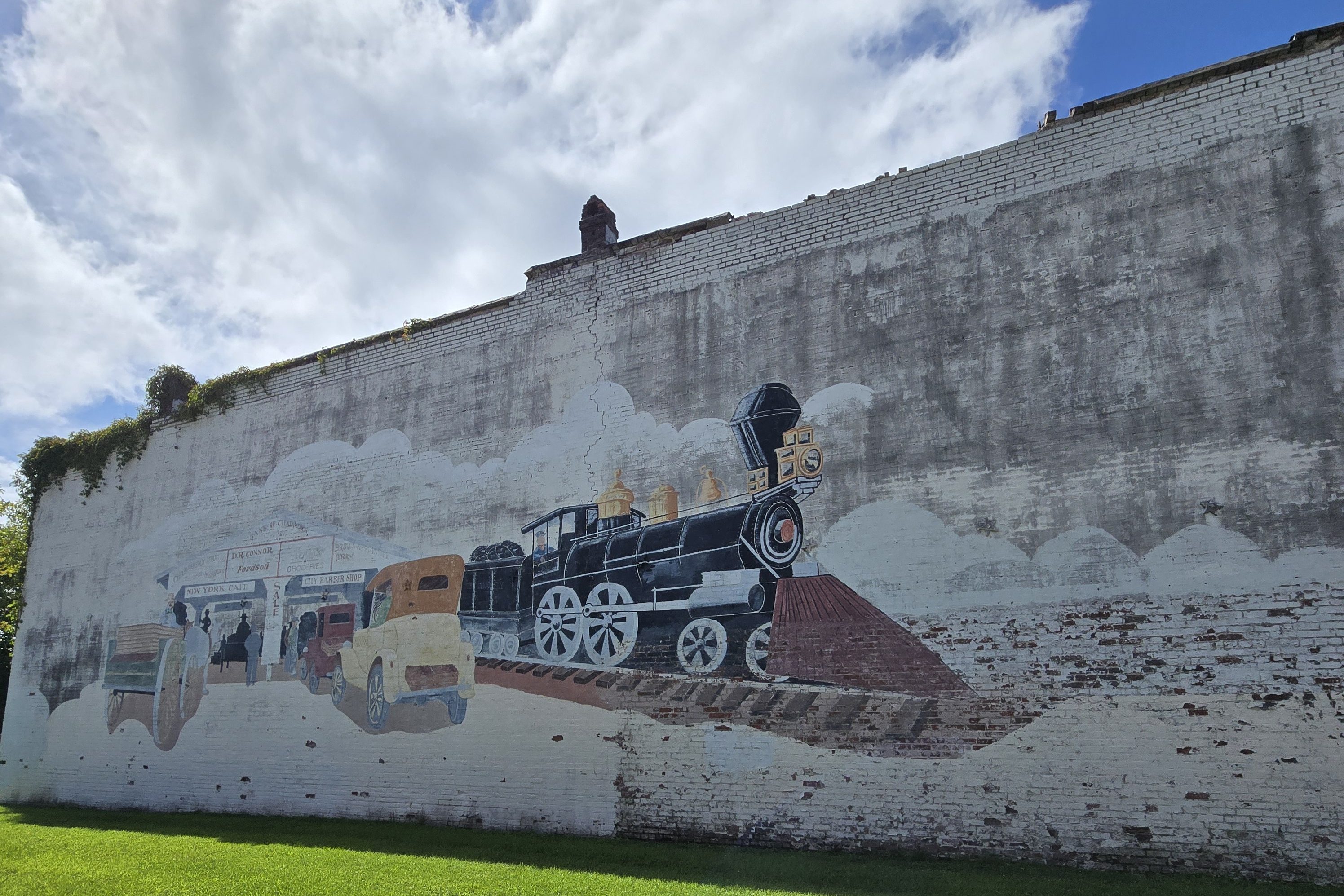
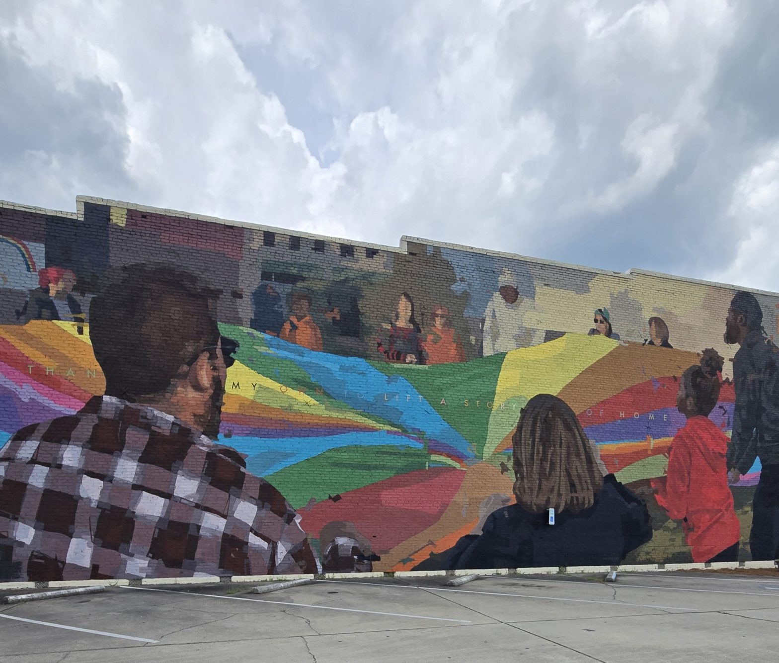
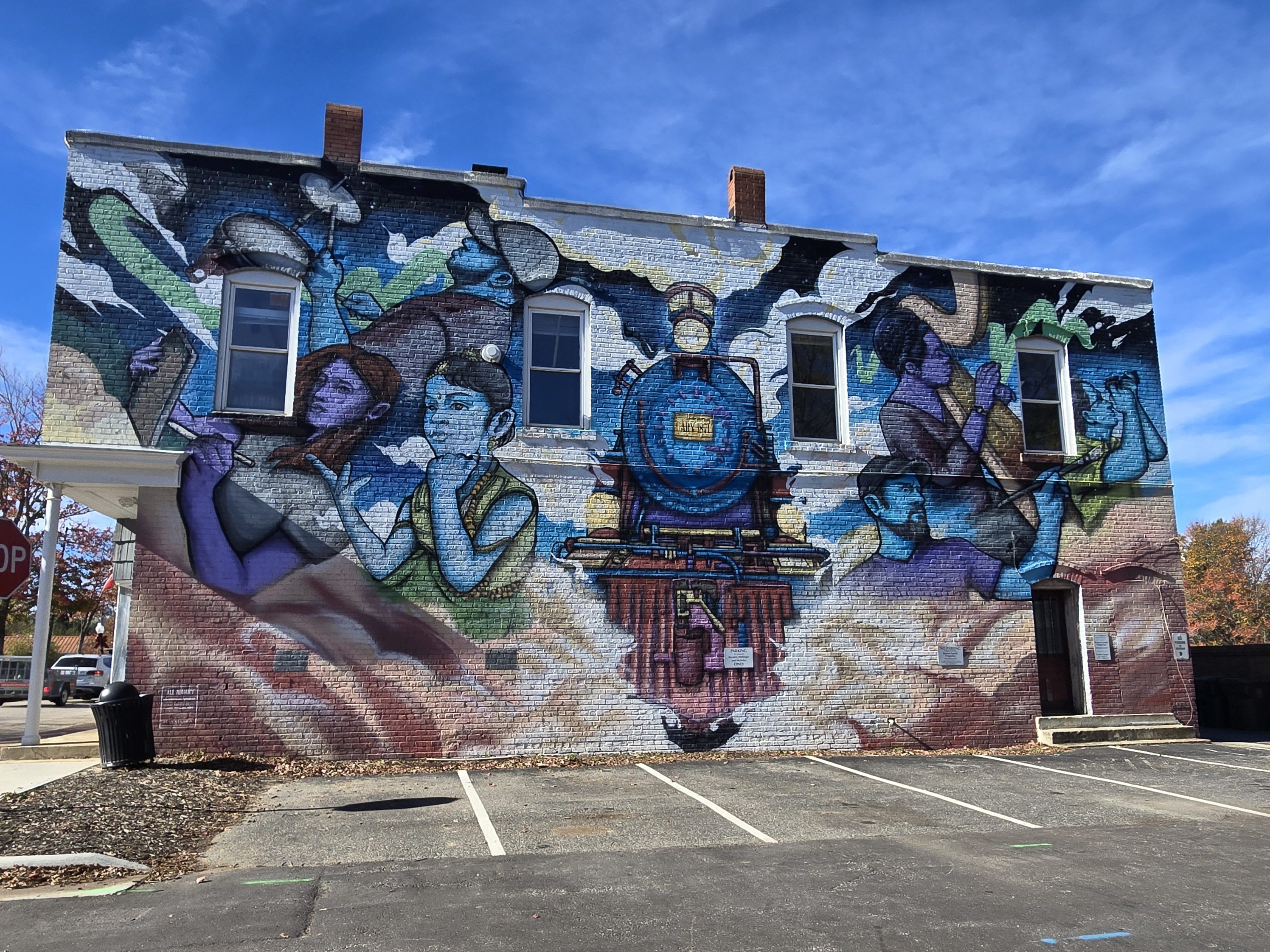
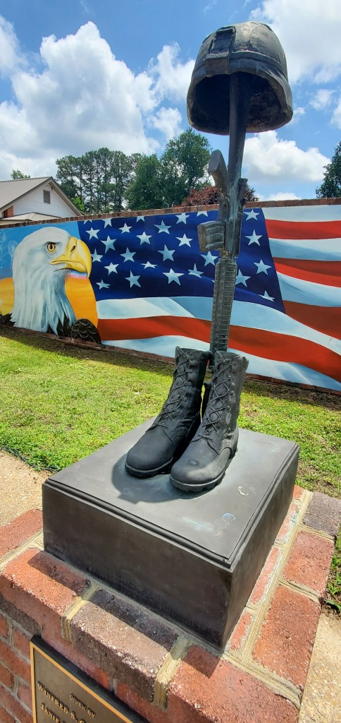
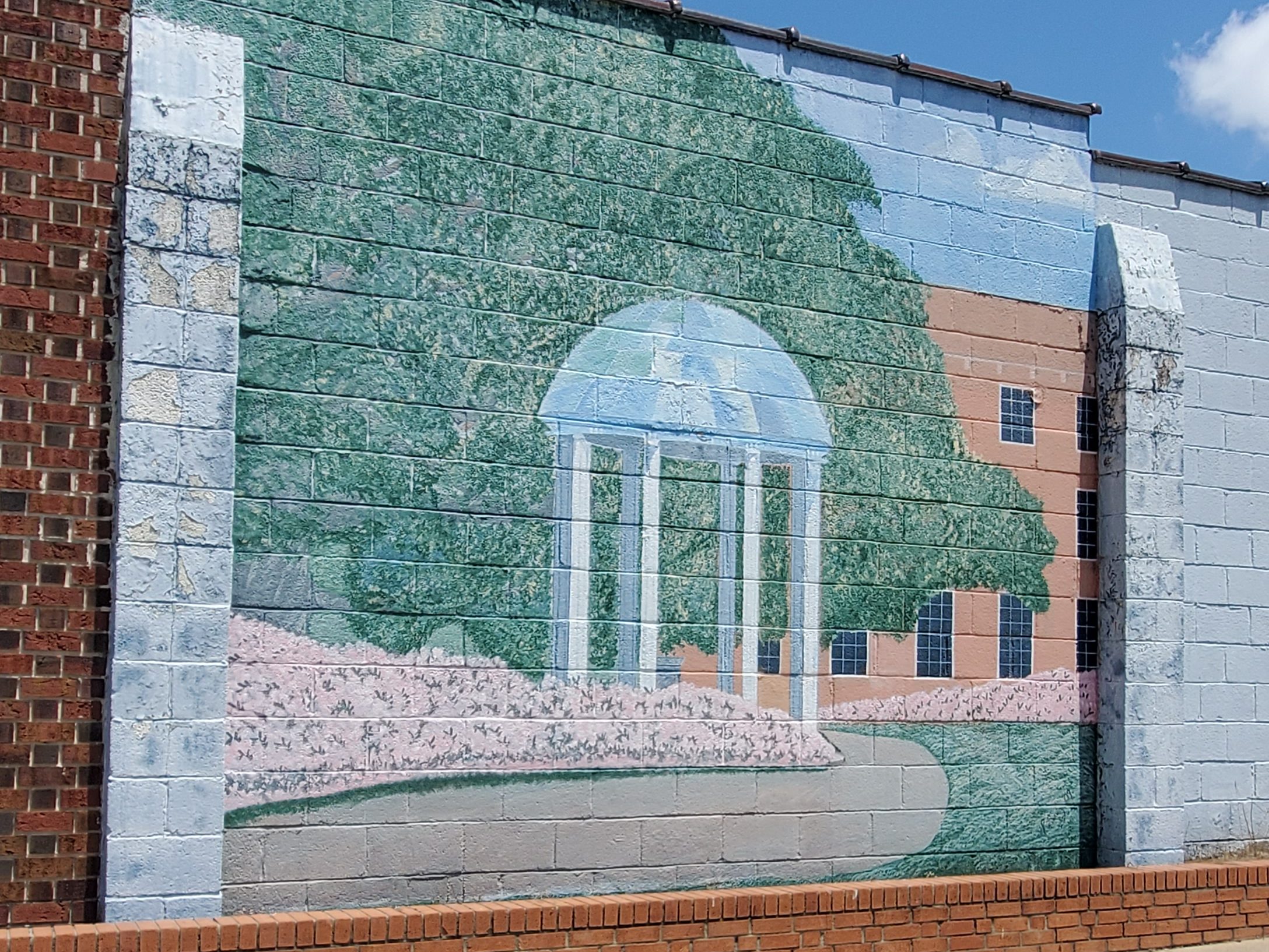
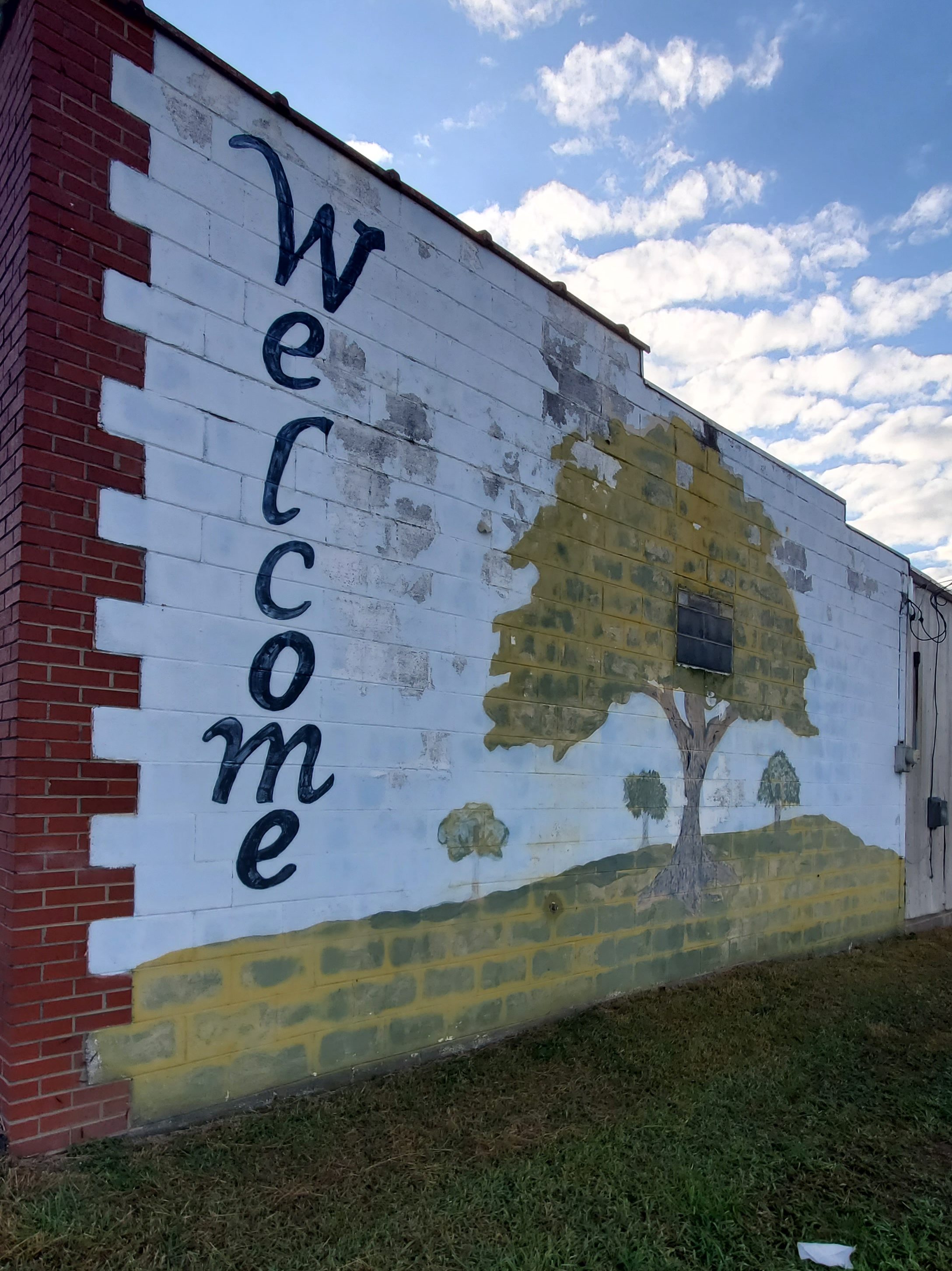
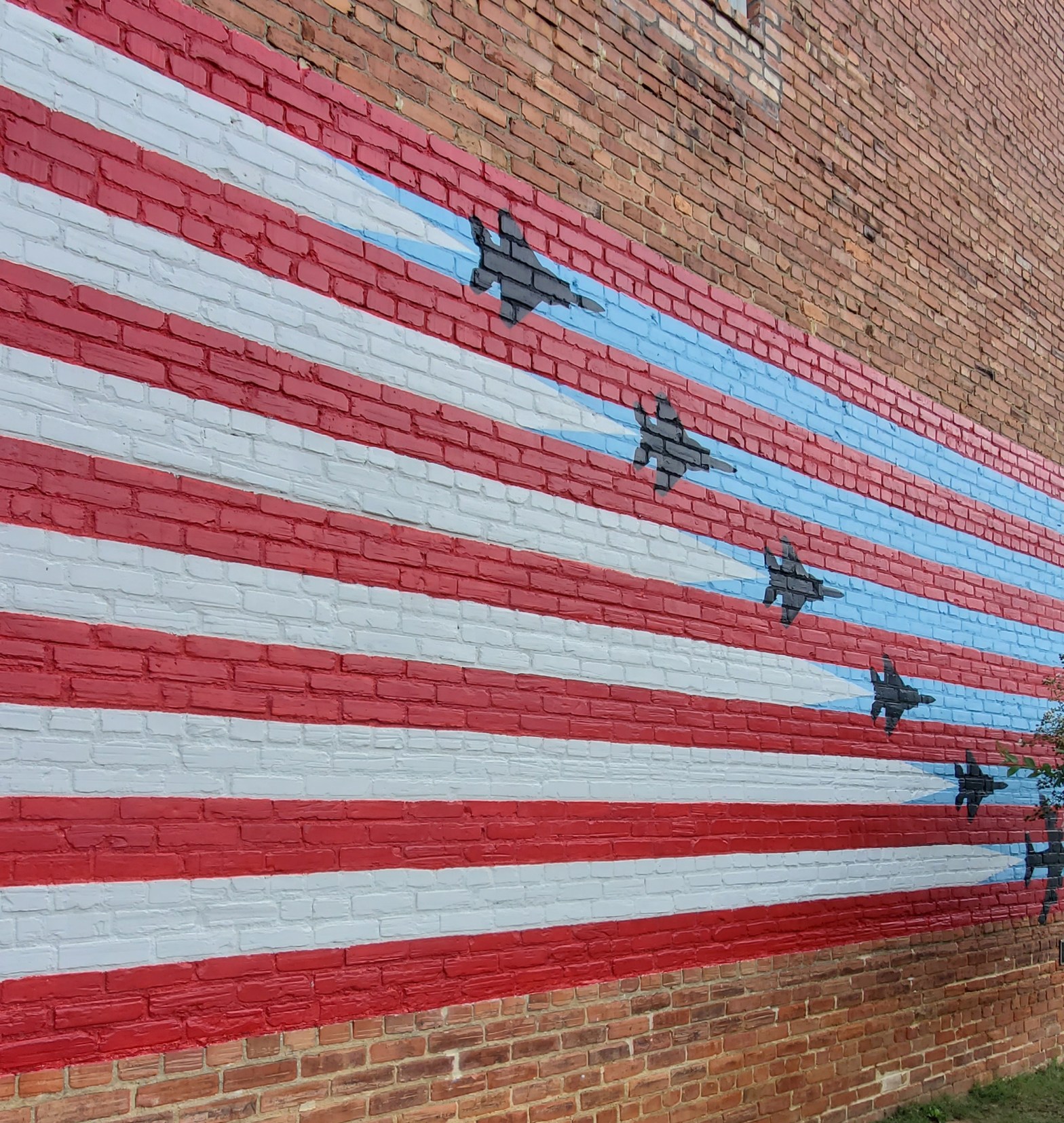
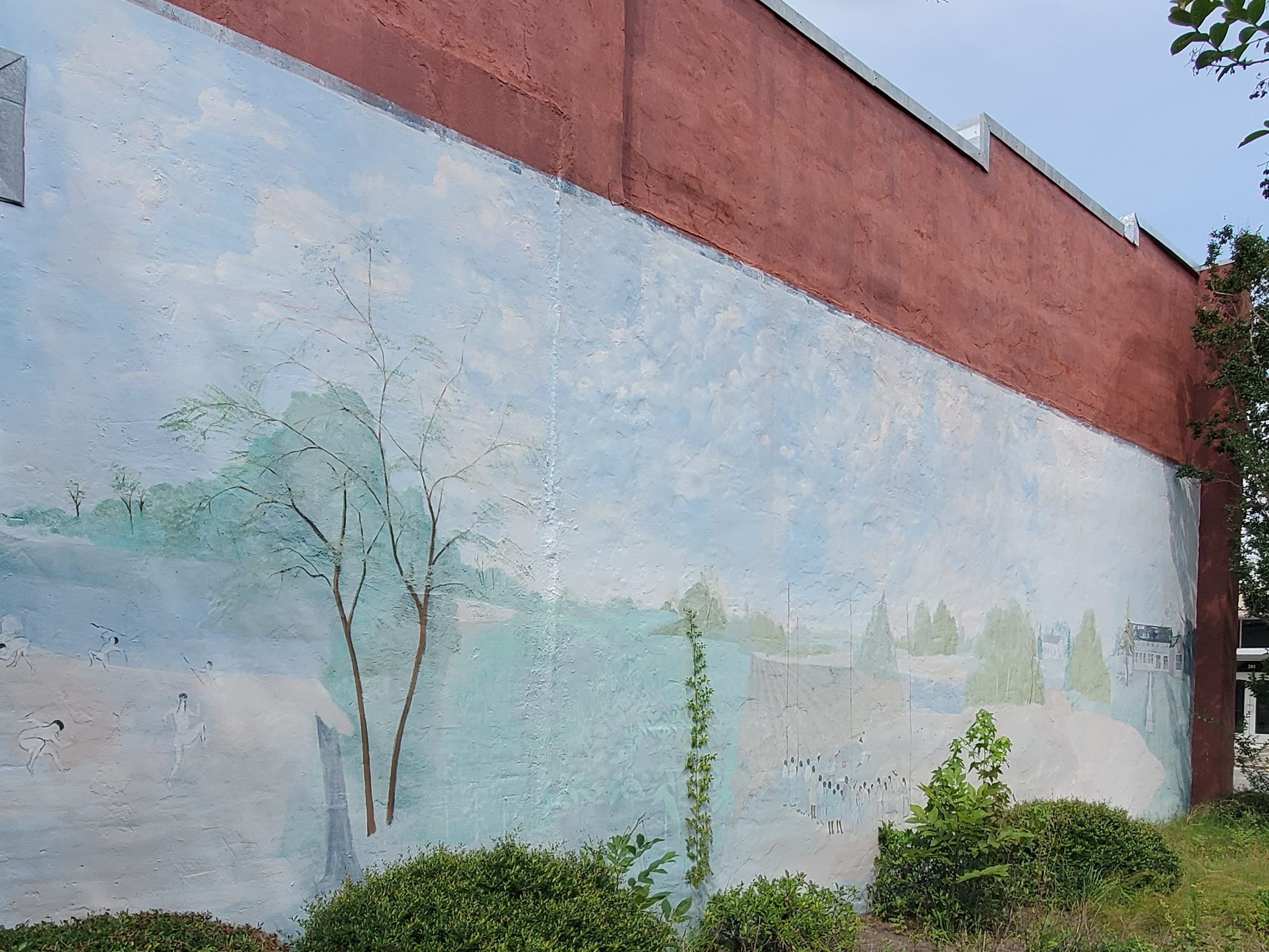
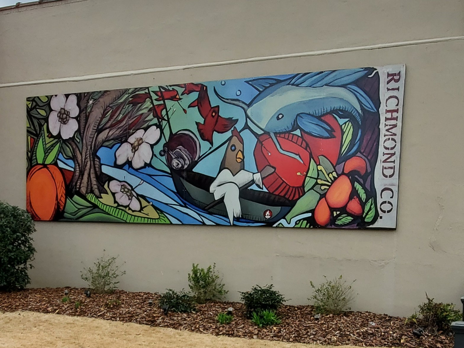
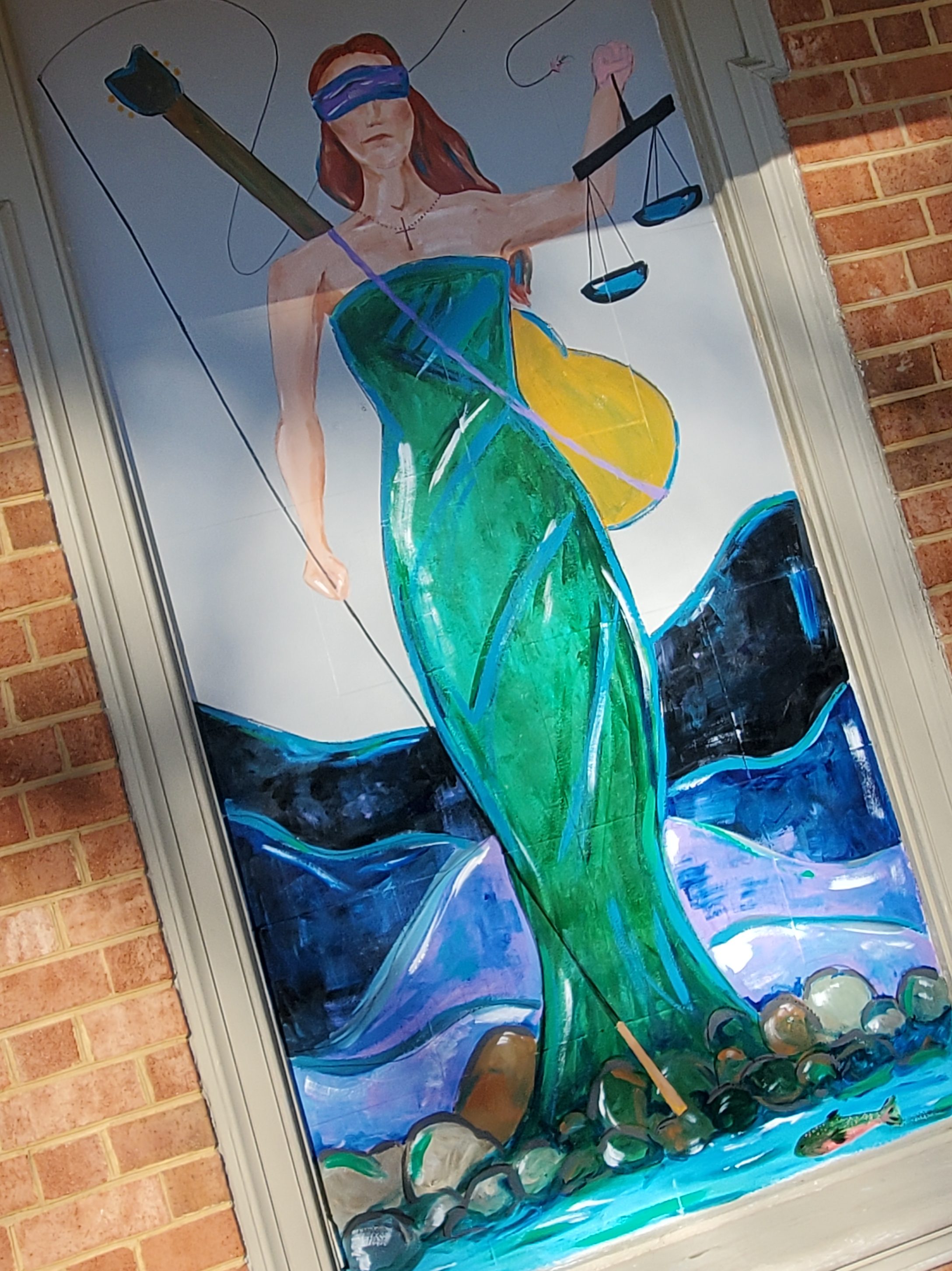
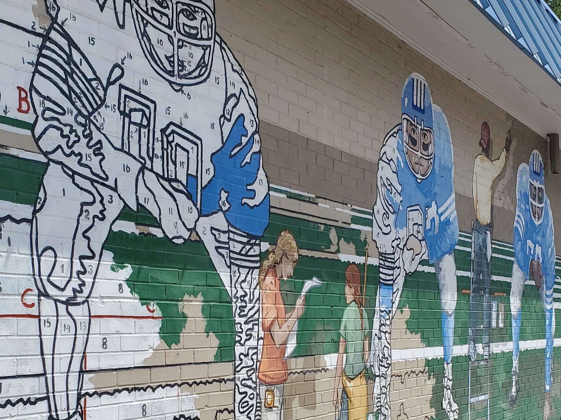
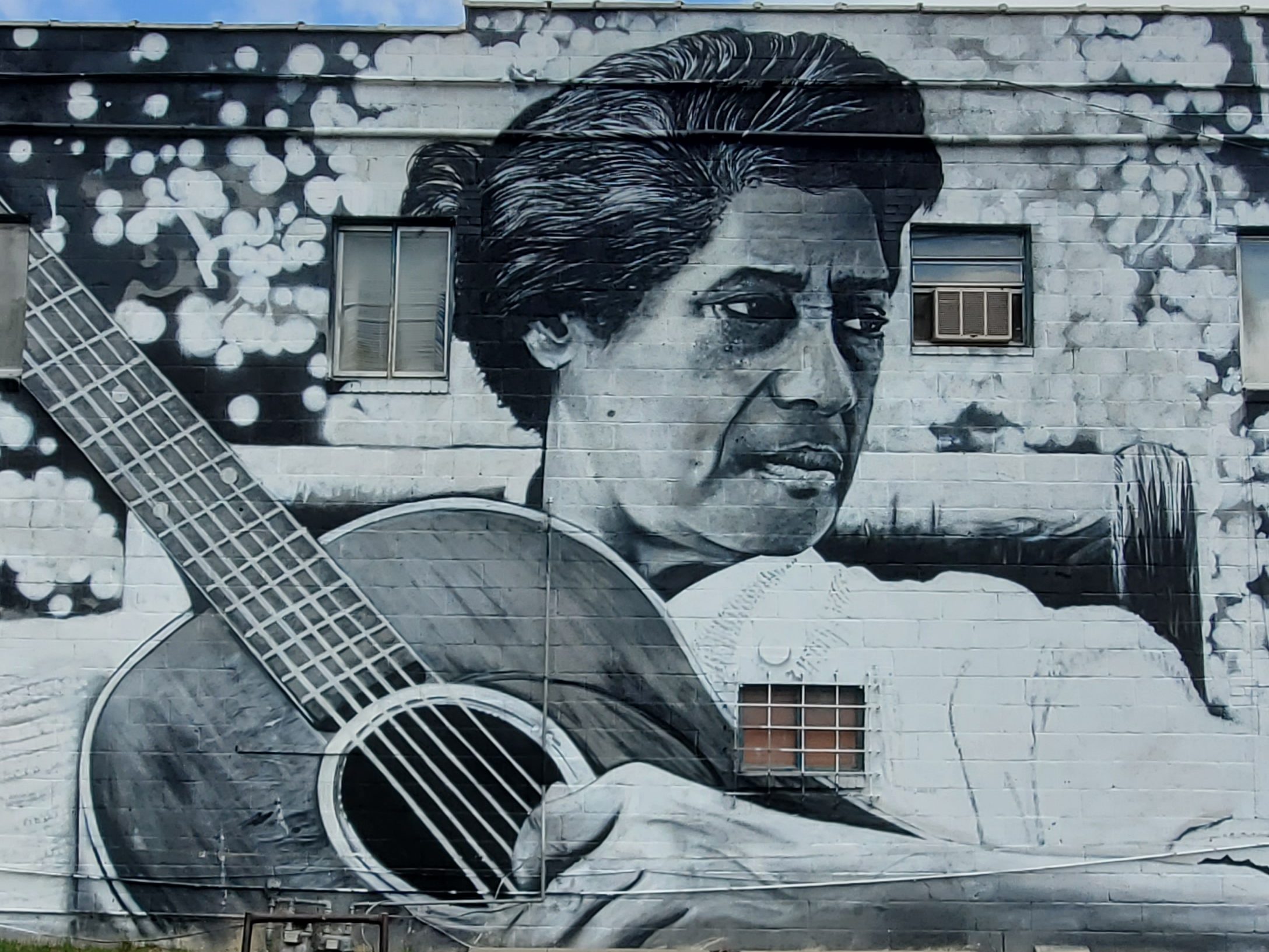
Roanoke Valley Veterans Museum This blogger has visited many veteran museums throughout North Carolina, and this one ranks at the top of the list. You’ll find some amazing displays at the Roanoke Valley Veterans Museum (102 E N. Main St.). But, perhaps even more importantly, the museum director David Johnson is an amazing wealth of knowledge — and was even working in the Pentagon on the day of the 911 attacks and when one of the planes was flown into the Pentagon. If you are even remotely a history buff, plan to stay a while. Johnson is enthusiastic and will be more than happy to share his knowledge and experiences with you. I found his stories to be amazing. Be sure to check out the mural on the side of the building, and Johnson can tell you the history behind the mural as well.
Frank’s Fine Arts Stop by Frank’s Fine Arts (133 E S Main St.) and peruse through the beautiful art pieces — all for sale — as well as the neighboring leather shoppe, which are conjoined in the same space.
Hollister
Medoc Mountain State Park Whether staying for a week or weekend in the area of just for the day, you’ll want to make a stop at Medoc Mountain State Park (1541 Medoc State Park Rd.) in Hollister, NC. Here, you’ll find seven walking trails totaling more than 10 miles, including a miniature rapids, as well as bridle and biking trails and picnicking and camping facilities. Medoc Mountain’s highest point reaches 325 feet above sea level and is the core of what was once a larger mountain range. The park is situated on the ancestral homelands of the tribe currently known as the Haliwa-Saponi, descendants of the Saponi, Tuscarora, Tutelo, and Nansemond Indians.
Enfield
Enfield is a town in Halifax County, North Carolina, United States, and was founded in 1740. It is the oldest town in Halifax County, and was once the world’s largest raw peanut market. Enfield is part of the Roanoke Rapids micropolitan area.
Hobgood
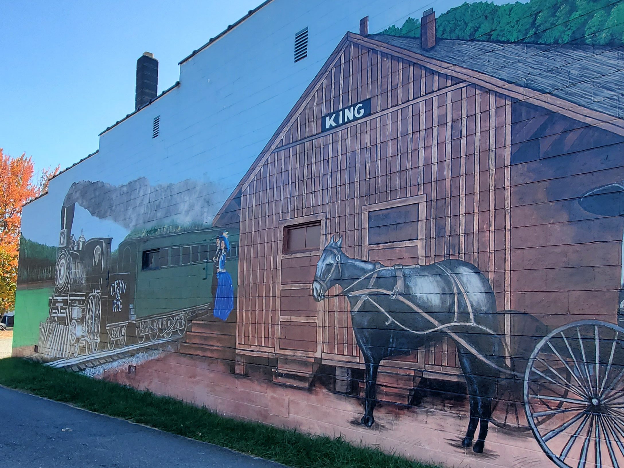
Hobgood is home to the annual Cotton Festival and to the former Atlantic Coastline Railroad Depot also know as The Hobgood Depot. The depot is located in Friendship Park in the center of town. The depot serves as the center of all community activities and projects and includes Internet access for visitors, a conference room and railroad museum. Hobgood is also home to one of the many Napolean Hill murals located throughout the eastern portion of the state. You’ll find 10 total Napolean Hill murals in Halifax County and some in Pitt County as well.
Scotland Neck
You’ll find another Napolean Hill mural in Scotland Neck at 1014 Main St. Scotland Neck is also home of the annual Crepe Myrtle Festival.
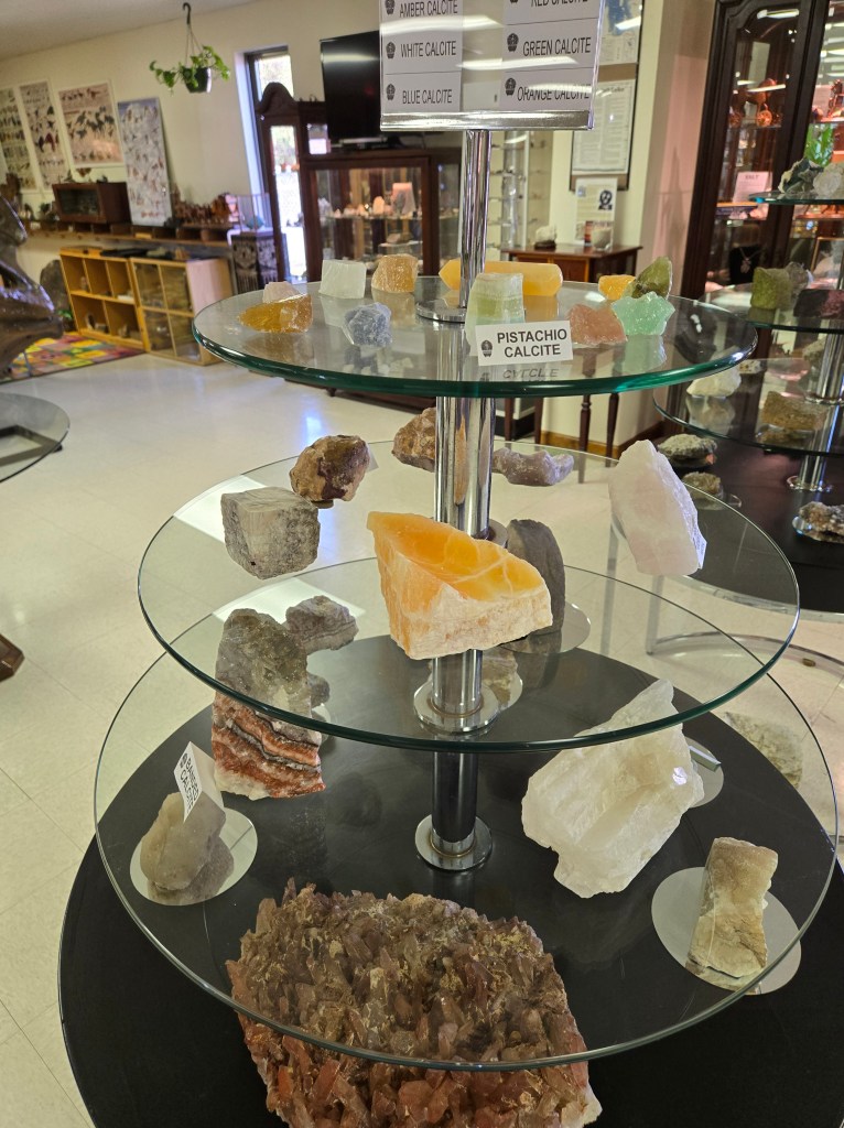
Rock Museum at Kaye Lee’s Corner In the same parking lot and directly across from the Food Lion, you’ll find the Rock Museum (37 Food Lion Rd.), offering tours, classes, educational programs, and annual shows and events surrounding geology and the area’s geological history.
Sylvan Heights Bird Park Scotland Neck’s biggest draw is the Sylvan Heights Bird Park (500 Sylvan Heights Park Way), featuring more than 2,000 rare and endangered waterfowl, pheasants, parrots, toucans, and more. Plan to be spend a few hours here perusing through the aviaries, some of which allow you to get up close and personal with some of the bird life. The park is divided into regions (Australia, Eurasia, North America, South America, Africa) as well as Wings of the Tropics, Birds of Paradise, Endangered Birds, and Penguin Point. The park invites you to see birds in a whole new way!
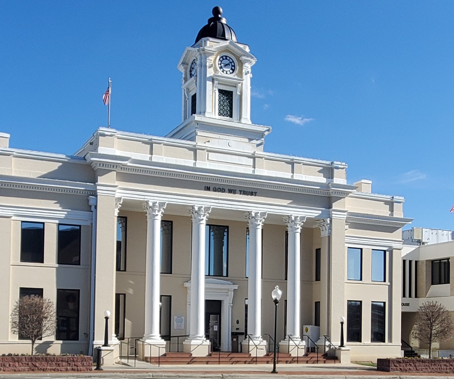
Halifax
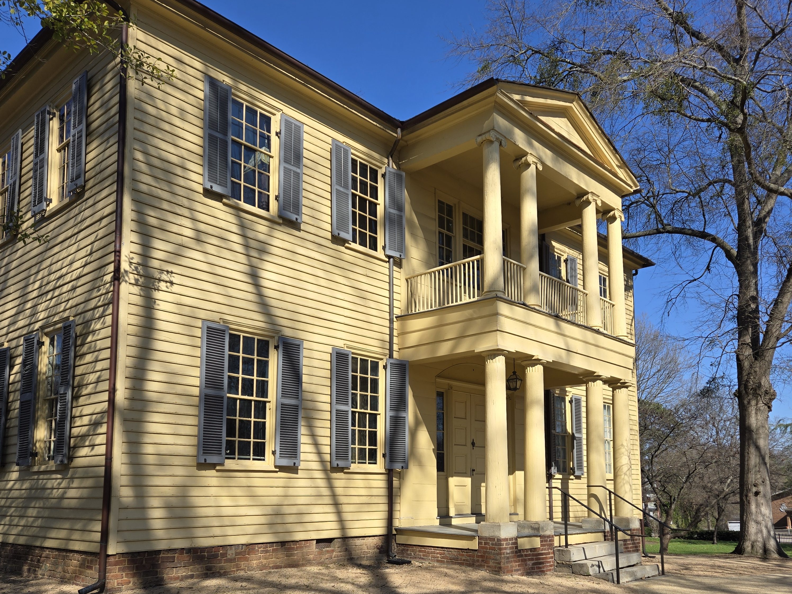
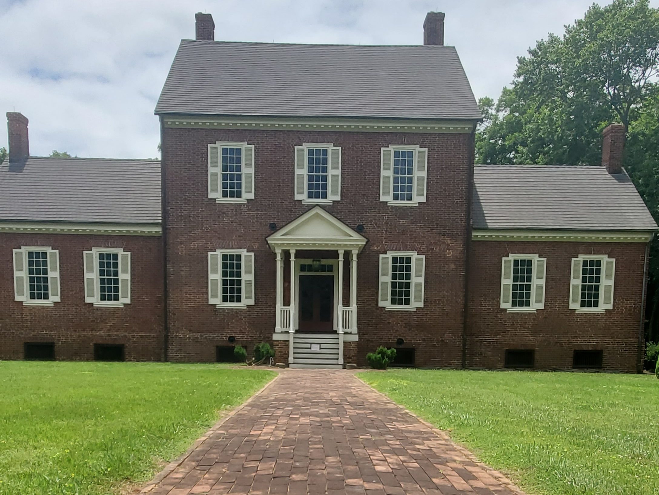
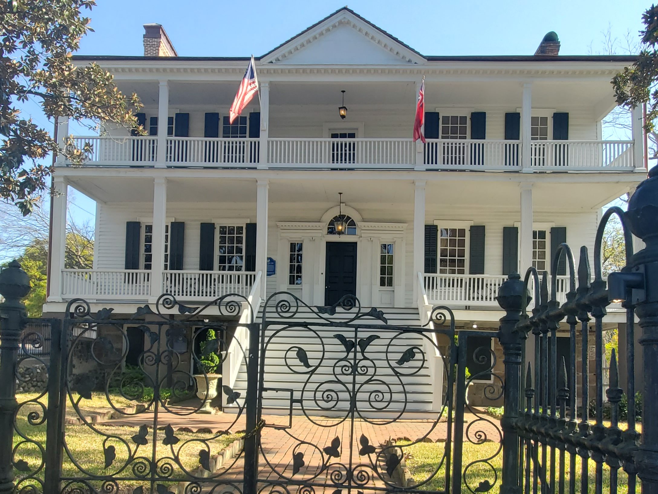
Known as “The Birthplace of Freedom,” Halifax is the location for the April 12, 1776, adoption of the Halifax Resolves, which was the first official action by a colony calling for independence from Britain. Halifax was established in 1757 and named for George Montagu-Dunk, 2nd Earl of Halifax. In January 1759 it became the county seat of the new Halifax County and the town developed into a commercial and political center at the time of the American Revolution.
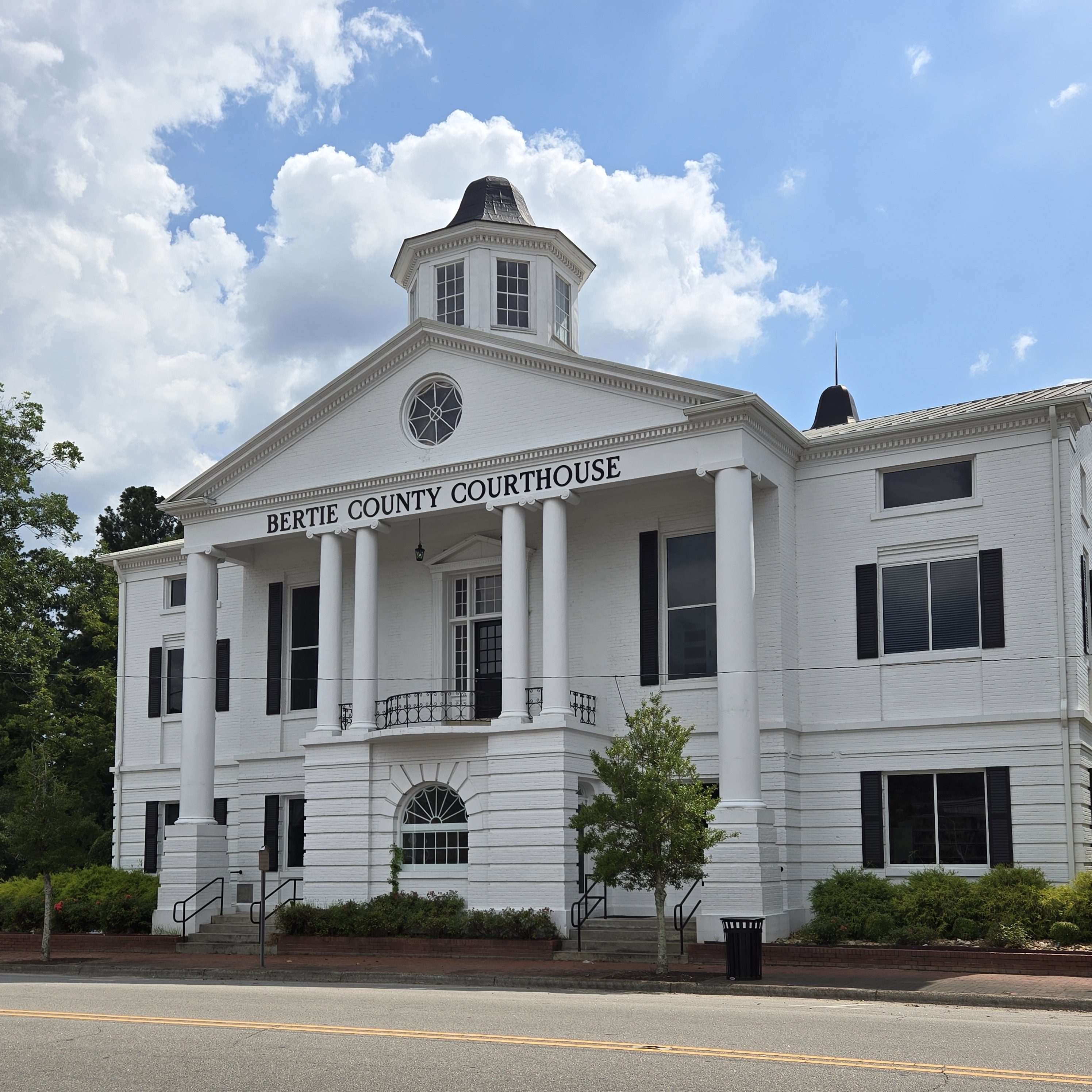
The Church of the Immaculate Conception and the Michael Ferrall Family Cemetery, William R. Davie House, Eagle Tavern, Halifax County Courthouse, Halifax County Home and Tubercular Hospital, Halifax Historic District, Sally-Billy House, and St. Mark’s Episcopal Church are all listed on the National Register of Historic Places. You can visit many of these building independently. The Eagle Tavern has several in-depth, historical exhibits and artifacts throughout the building.
The town of Halifax and the Roanoke River were also strategic locations on the Underground Railroad. On March 9, 2015, an Amtrak passenger train collided with a tractor trailer in Halifax, with part of the train derailing and 55 passengers were injured. You’ll find another Napolean Hill mural in Halifax at 16 King St. as well as the Halifax Underground Railroad Trail and Halifax State Historic Site at 25 St. David St.
Weldon
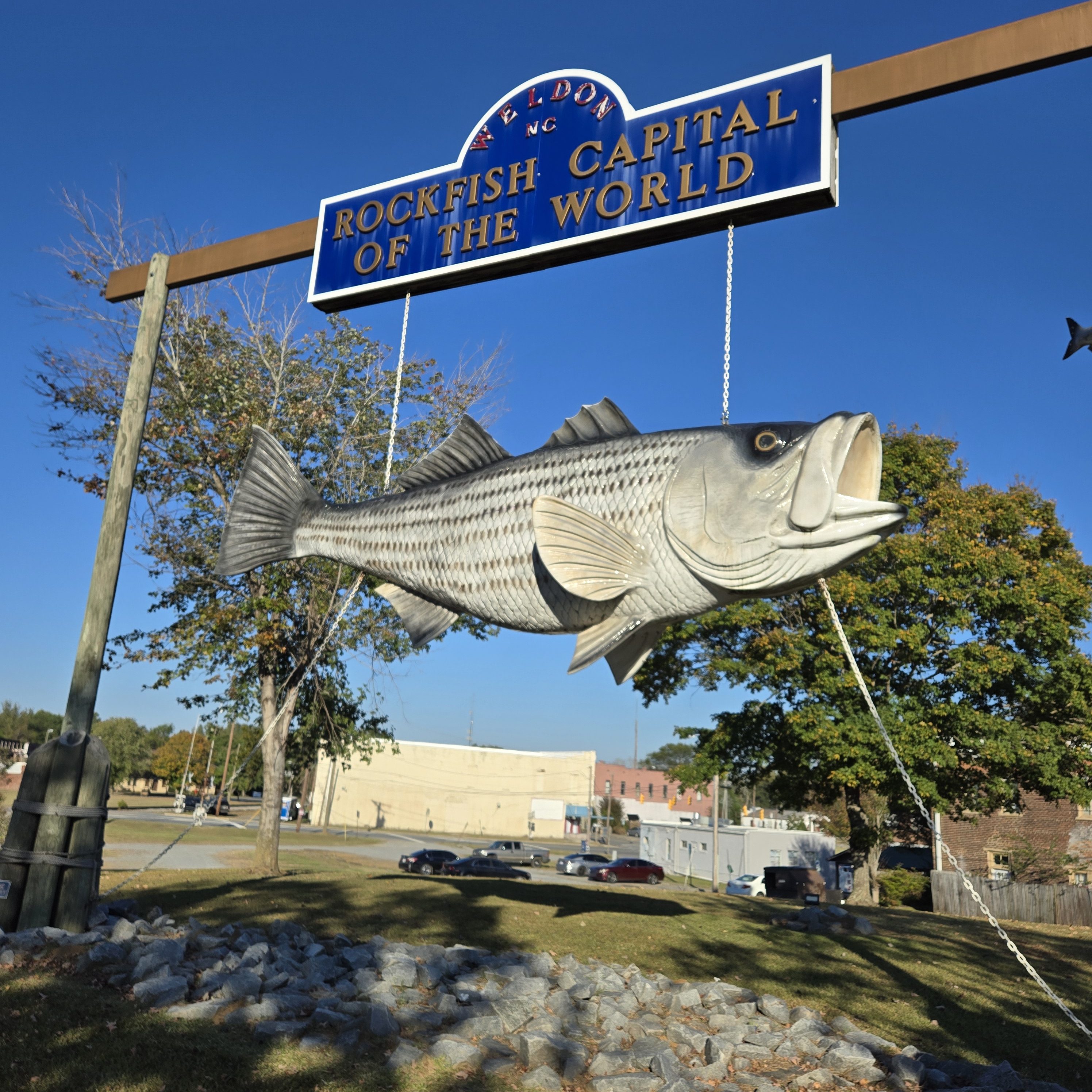
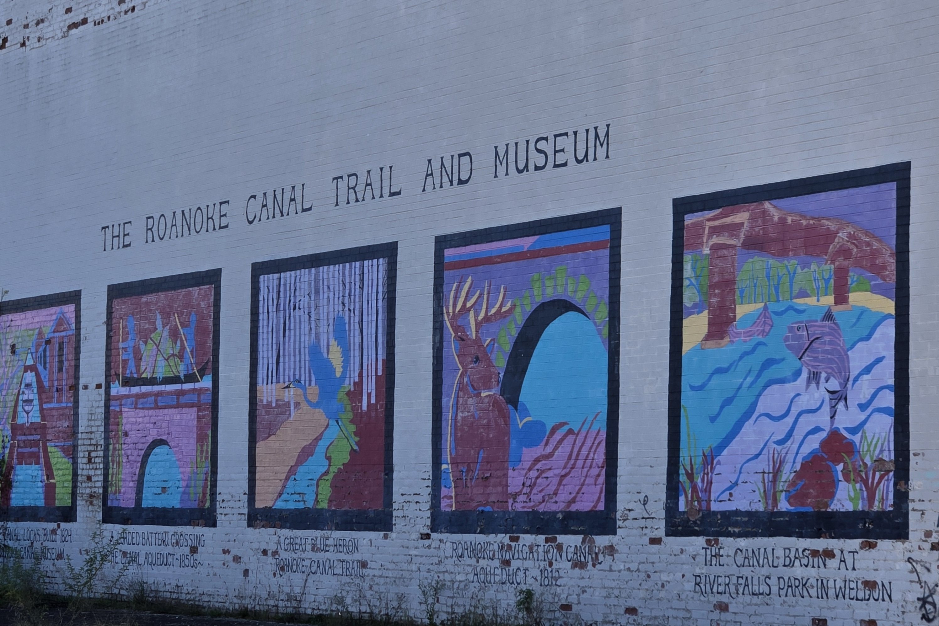
Weldon is the Rockfish capital of the world! In 1752, Daniel Weldon purchased 1,273 acres of land on the Roanoke River. His plantation became known as Weldon’s Landing. As it was just below the fall line, Weldon’s Landing was the westernmost point of navigation along the Roanoke. The Roanoke Canal was built in 1823 to bypass the rapids and open up trade to Virginia. The aqueduct across Chockoyotte creek was built near Weldon’s Landing, bringing an economic boom to the area. The canal is now dry, and is a hiking trail open to the public.
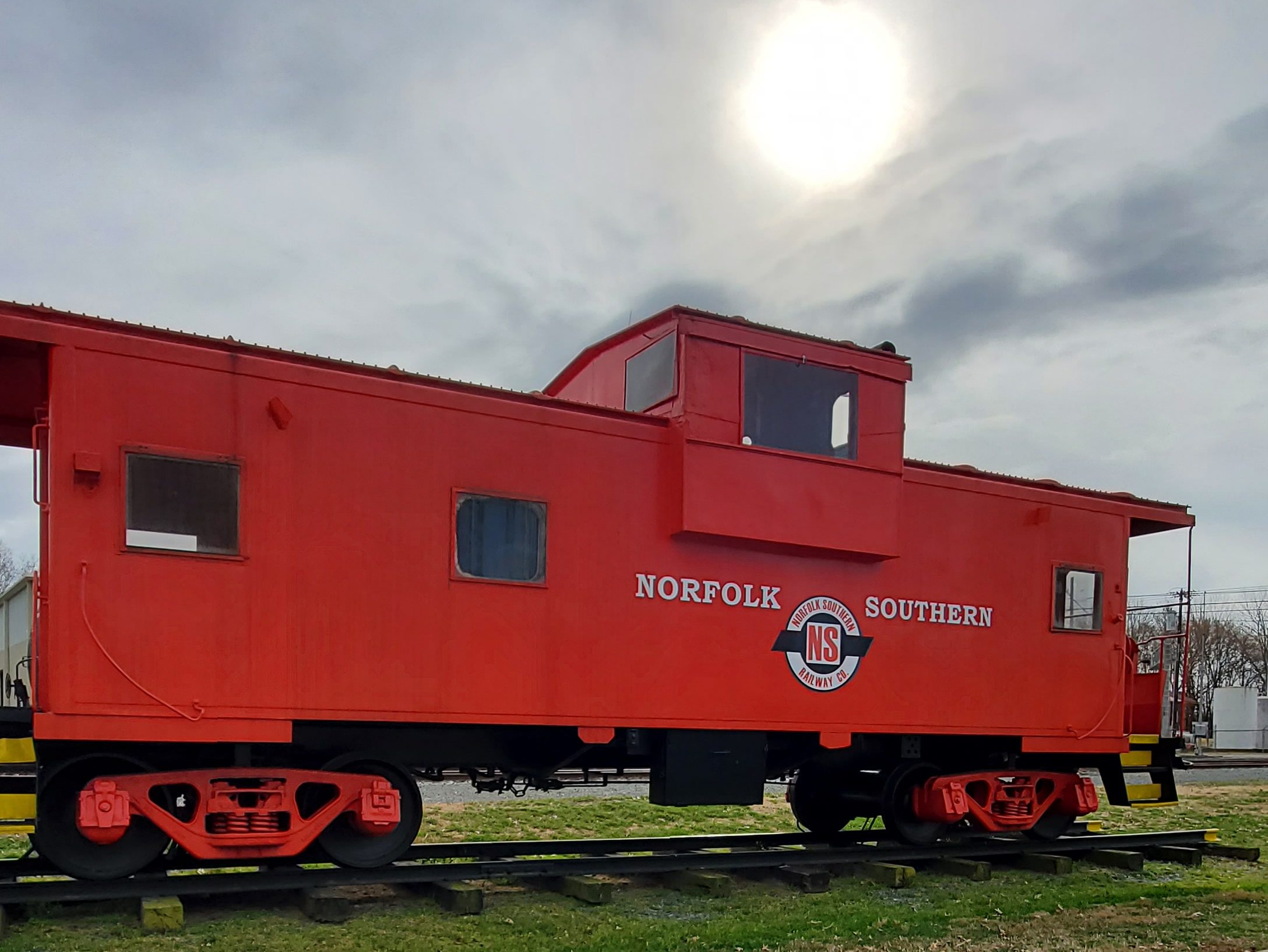
Weldon was the first railroad hub in the American South, as the Seaboard and Roanoke Railroad terminated in Weldon. In 1841, the Wilmington and Weldon Railroad was completed, also terminating in Weldon. At the time, it was the longest railroad in the world, which led to the incorporation of the town in 1843. The Petersburg and Roanoke Railroad in 1848 and the Raleigh and Gaston Railroad in 1853 both extended to terminate in Weldon. During the Civil War, both railroad bridges over the Roanoke were burned. Only the Seaboard and Roanoke rebuilt their bridge.
You’ll find another Napolean Hill mural in Weldon at Washington Ave & E 3rd St. Singer and actor, also of American Idol fame, Chris Daughtry is from the area.
Weldon Mills Distillery North Carolina’s most awarded small-batch distillery, Weldon Mills Distillery (100 Rockfish Dr.) has become the #1 Micro-Distillery in America and seen its bourbons win Platinum and an array of other awards in an extraordinarily competitive environment. The distillery says they offer the world’s best bourbon experience through a lineup of elegant products with unrivaled quality and craftsmanship. Stop by for a tasting in the historic millhouse just steps from scenic views of the Roanoke River. They also offer RV camping as well as a ride on their historic trolley from the historic mill house to the distillery.
Roanoke Rapids
Roanoke Rapids was first settled as a mill town and is known for its many historical sites. The original Roanoke Rapids High School building or Senior building as it is sometimes referred, opened in 1921 and is still in use. The building embodies many elements of Elizabethan Gothic and Tudor Revival architecture in its castle-like facade. The high school is the dominant building in the city’s central core and is flanked by another castle-like structure which formerly housed a National Guard Armory.
The Roanoke Canal Museum and Trail is one of the city’s oldest historical sites. The 1823 canal lock building has been adapted as a museum to show the significance of the canal system to American westward expansion. It offers an in-depth look at the influential people who pushed for the Roanoke River to become a source of trade and navigation, as well as the commodities that were shipped and traded on the Roanoke River. The trail, over seven miles long, is adjacent to the museum and largely parallel to the Roanoke River.
While traversing Columbus County, you’ll find frequent roadside produce stands, carrying a variety of local fruit and vegetables, including corn and watermelon. You’ll also see numerous tobacco fields throughout the county. The area is also home to many wetlands and marshy areas, often with the water levels not far from the roadway. So take special care when driving on certain roads, as there may not be much room for error.
The area comprising Columbus County was originally inhabited by the Waccamaw people. Historically, the “eastern Siouans” had territories extending through the area of Columbus County prior to any European exploration or settlement in the 16th century. English colonial settlement in what was known as Carolina did not increase until the late 17th and early 18th centuries. Following epidemics of new infectious diseases, to which indigenous peoples were exposed in trading and other contact, the Waccamaw and other Native Americans often suffered disruption and fatalities when caught between larger tribes and colonists in the Tuscarora and Yamasee wars.
Waccamaw Siouan ancestors retreated for safety to an area of Green Swamp near Lake Waccamaw. As America was colonized by the British, the area encompassing Columbus County was first organized part of the Bath Precinct of North Carolina, established by the British Crown in 1696. In 1729, a southern portion was split off by the General Assembly to create New Hanover County, and five years later Bladen was formed out of part of New Hanover. In 1764, Brunswick County was formed out of Bladen and New Hanover. Throughout this time, the area was largely forested and had few white settlers, though the General Assembly established two roads through the area in 1764. William Bartram, a botanist from Pennsylvania, journeyed to Lake Waccamaw to study the flora and fauna of the region in the 1730s, creating the first detailed written account of the area. At least two skirmishes of the American Revolutionary War were fought on Columbus soil: one near Pireway and another at Brown Marsh.
Columbus County was created by the General Assembly on December 15, 1808 and was formed from parts of Bladen and Brunswick counties and named in honor of Christopher Columbus. The county’s borders were modified several times by legislative acts between 1809 and 1821. In 1810, a community was platted on land owned by James B. White for the purpose of creating a county seat. It was originally known as White’s Crossing before being incorporated as Whiteville in 1832.
The construction of a railroad along the Bladen-Columbus border in the 1860s spurred growth. The laying of the Wilmington, Columbia and Augusta Railroad later in the decade connected Whiteville with Wilmington and supported the development of strong lumber and naval stores industries. The county also produced corn, wheat, cotton, and wool.
Although the county was spared direct fighting during the Civil War, war demands stressed the local labor and food markets, and severe rains in 1863 diminished grain yields. After Wilmington fell to Union troops in February 1865, Union marauders sacked Whiteville. After the war, Columbus County’s economy grew more heavily reliant on corn and cotton production. In 1877, part of Brunswick County was annexed to Columbus.
Tobacco was introduced as a crop in Columbus in 1896, and that year a tobacco warehouse was established in Fair Bluff. It remained a marginal crop until 1914, and at the conclusion of World War I it overtook cotton as the county’s major cash crop.
Chadbourn
A post office called Chadbourn has been in operation since 1882. It was incorporated in 1883, being named after a local family engaged in the lumber industry. In 1895, strawberries were introduced in the Chadbourn area, and by 1907 Chadbourn had become one of the leading strawberry producers in the world.
Chadbourne Depot Museum The old Chadbourn Depot Museum (201 W 1st Ave.) contains a lot of history about this little town. This museum was once a major transportation hub for trains, which hauled fresh produce across the country — including strawberries. Chadbourn is where the largest one-day shipping of strawberries happened — and one reason why the Strawberry Festival is now celebrated here. Today, the depot museum is a popular gathering and event spot, where celebrations, cookoffs, and other activities are hosted.
Cerro Gordo
Cerro Gordo was incorporated in 1874, taking its name from the 1847 Battle of Cerro Gordo in Mexico. The name Cerro Gordo (Spanish for ‘fat hill’) describes its slightly higher elevation than the rest of Columbus County, although it is located in the Coastal Plains region of North Carolina. Like much of the county, the local economy of Cerro Gordo heavily relies on agriculture and hog production.
Fair Bluff
Fair Bluff got its name from a bluff overlooking the Lumber River, where steamboats used to carry goods and passengers up and downstream. In 1807, plans were made to build a town upon the lands of John Wooton at the bluff to be known as Wootonton. Although the town was established but the name remained Fair Bluff and the community was reincorporated in 1873.
Agriculture has always been a mainstay of the the town’s economy, including tobacco. By the 1980s, tobacco growing subsided. The downtown area continued to thrive until the late 1980s, when a car dealership moved from the business district to another location. Haphazard town planning saw a mixture of residential, business, and industry all over town. Tens of millions in U.S. government grants poured into the city beginning in the mid-1980s and onward. But the town continued to decline and people left for better opportunities elsewhere. The same fate happened with neighboring towns of Tabor City, Boardman, Brunswick, Cerro Gordo, and Chadbourn.
In 1999, Fair Bluff experienced devastating flooding from Hurricane Floyd. In 2012, the Police Chief of Fair Bluff, Marty Lewis, was arrested, tried, and convicted for selling and delivering oxycodone and possession with the intent to sell and conspiracy to traffic while acting as police chief. He was sentenced to a minimum of seven years in prison and fined $100,000. On April 9, 2015, Marty Lewis filled an appeal of his case. On November 3, 2015, the verdict was unanimously affirmed by the North Carolina Court of Appeals, leaving in place the 90 to 117-month prison sentence originally imposed.
In October 2016, the town was again devastated by flooding on the Lumber River from Hurricane Matthew, prompting the evacuation of hundreds of residents. Floodwaters reached the town hall, police department, fire department, a grocery store, and a school.
In September 2018, Fair Bluff was flooded again by the impact of Hurricane Florence, forcing evacuations and leaving the downtown area under water, destroying 72 homes. After Florence, many buildings in the downtown area of the town were left abandoned, with no plans to reoccupy or repair them. The town’s only factory closed several months later, and hundreds of residents moved away. The federal government bought out residential properties in the community, straining the local government tax base. The town government drew up plans to level the historic business district and turn it into a park, and build a new business district further away from the Lumber River.
Fair Bluff celebrates a Watermelon Festival every July.
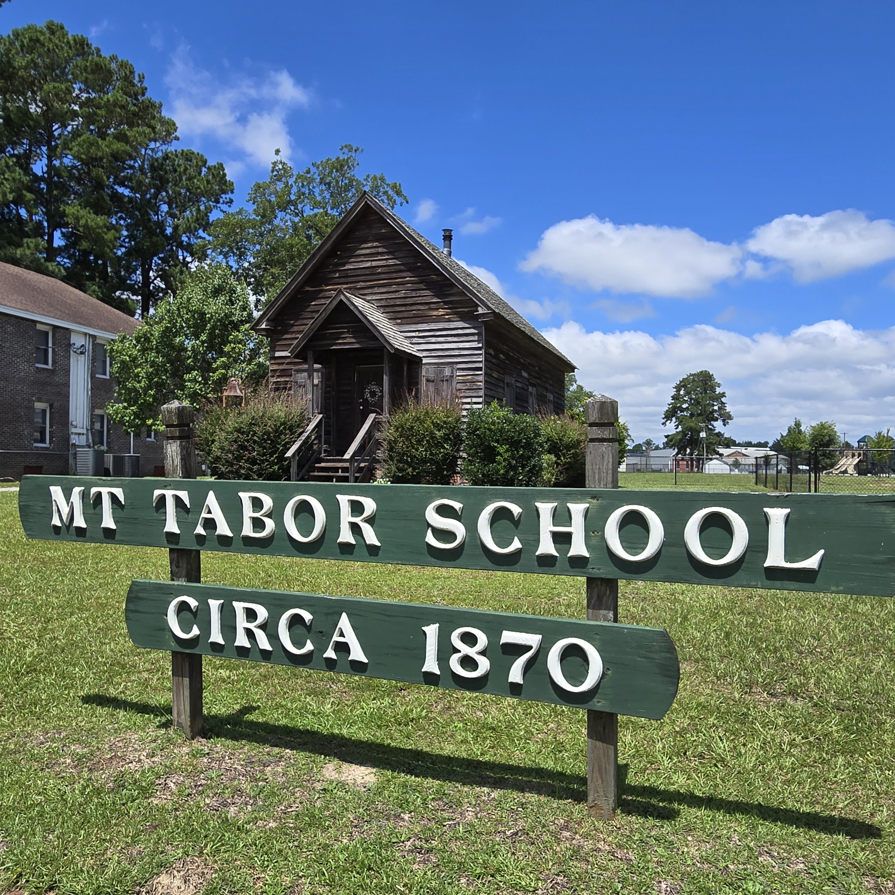
Tabor City
Early settlers in the Tabor City area farmed, raised cattle & pigs, and manufactured naval stores. From the longleaf pine trees come products used in shipbuilding. These products or “stores” are turpentine, rosin, tar and pitch. Pitch was needed to coat the hulls of ships to protect them in tropical waters.
The original community took its name from the first prominent church in the area, the Mount Tabor Baptist Church(now the Tabor City Baptist Church), which itself is named after the biblical Mount Tabor, and was founded in 1838. A village coalesced around the area of the church, which was organized as a town shortly after 1840. The town officially incorporated in 1904.
Business activity started in Tabor City by the mid-1850s, with the development of a saw mill, turpentine still, grocery store and dry goods store. The Atlantic Coast Line Railroad located a station in the town in 1886. The turpentine industry was huge in the area throughout the 19th Century. Many wagonloads of turpentine, rosin and pitch were carried to the rail station in Grist, NC, for shipment to Wilmington, North Carolina and beyond. The town was officially incorporated in 1905. In 1906, William Fowler donated land for the Tabor City Baptist Church.
Strawberries became an important crop in the 1880s when the development of the railroad enabled them to be shipped to markets in large cities. The Anderson Shingle Company made shipping containers for strawberries. Cotton fell out of favor when boll weevils negatively impacted crop production. Then tobacco became the golden crop with the first tobacco warehouse built in 1909.
Originally named Mt. Tabor, many would shorten the name to Tabor when writing correspondence. With mail delivery by the USPS, Tabor would be confused with Tarboro, North Carolina, due to the similarities in spelling. By 1935, US Postal authorities demanded a name change and since Tarboro was much larger, Mt Tabor was told to pick another name. So, Tabor City was chosen.
Due to crimes in the area in the late 1950s and 1960s, especially fights at local bars, Tabor City earned the nickname “Razor City.” Even though many of the crimes occurred just across the border in South Carolina, the Razor/Tabor near-rhyme stuck. An economic downturn and severe recession, plus skyrocketing fuel costs in the early/mid-1970s resulted in business closures and poverty becoming the norm for many families.
By the eighties, tobacco use began declining. Along with global recession, the town and its people took another severe hit. More businesses closed and parts of downtown looked deserted as empty buildings fell into disrepair.
In late 1997, a massive facelift was performed on two blocks of S. Main Street in the downtown area. Southern Living magazine made contact with town leaders about an article they were doing about Christmas celebrations in small southern towns. For many decades, the town traditionally held an annual daytime Christmas parade. Storefronts were painted, new retro lampposts installed, and other aesthetic improvements costing tens of thousands of dollars were made in order to have a nighttime Christmas parade. A photo of the parade and short write-up were included in an article in the December 1997 issue of Southern Living magazine.
Today, the town focuses on agriculture, light manufacturing, retail and tourism. In addition, a large state prison provides many jobs for the area. Being so close to the coastal areas of Myrtle Beach and the Brunswick County beaches has led to a growth in the area housing industry. The Centennial Clock celebrating the town’s 100th anniversary was installed on Main Street.
A local citizen donated the lot containing the ruined front brick wall of the former Ritz theater to the town. Millions in government grants resulted in a complete rebuild effort that was completed in 2014. The former theater is now the Ritz Center, a community center for the arts. Town welcome signs were amended in 2019 to recognize country music legend Stonewall Jackson, a Tabor City native.
Tabor City holds the North Carolina Yam Festival on the fourth Saturday each October. The festival celebrates with crafts, train rides, classic cars and trucks, arts and vendors. Also during the Yam festival, an annual art show is held, and a “Miss Yam Festival” pageant is held for various age groups. The annual parade is considered a highlight of the festival. The annual week-long Spring Fling began in 2013 and celebrates the Town and people of Tabor City.
NC Visitors Center at Tabor City Tabor City has one of the most comprehensive Visitor Centers (301 East 5th St.) that I’ve seen in the state. I highly recommend stopping by to pick up a variety of rack cards, magazines, maps, and other publications for Tabor City, Columbus County, and all geographic regions of the state. Directly across from the Visitors Center, you’ll find the Mt. Tabor City Schoolhouse. (See below.)
The Garrell Depot The old Garrell train depot (105 Railroad St.)serves as a small museum that operates primarily during the Yam Festival and inlcudes a retired caboose as one of the displays available for exploration.
Mt. Tabor City Schoolhouse A circa 1870 one-room, intact, School House (213 East 5th St.) was restored by the historical society of Tabor City and Columbus County. This facility was purchased and donated to the Town of Tabor City by Richard Wright and still has its original six-inch-side pine floorboards and interior and exterior woodwork. The schoolhouse is located directly across from the Visitors Center.
Whiteville
Whiteville is the county seat and the most populous city in Columbus County, which was created in 1808. In 1810, an act authorized James Bunbury White to “lay off a town on his own lands in the county of Columbus” and appoint five commissioners. The town was sacked by Union forces during the latter stages of the American Civil War. The name Whitesville was officially changed to Whiteville by the U.S. Post Office in 1889.
In 1950, Whiteville fielded a professional minor league baseball team in the Class D Tobacco State League called The Whiteville Tobs; the club lasted only one season before disbanding from the entire league.
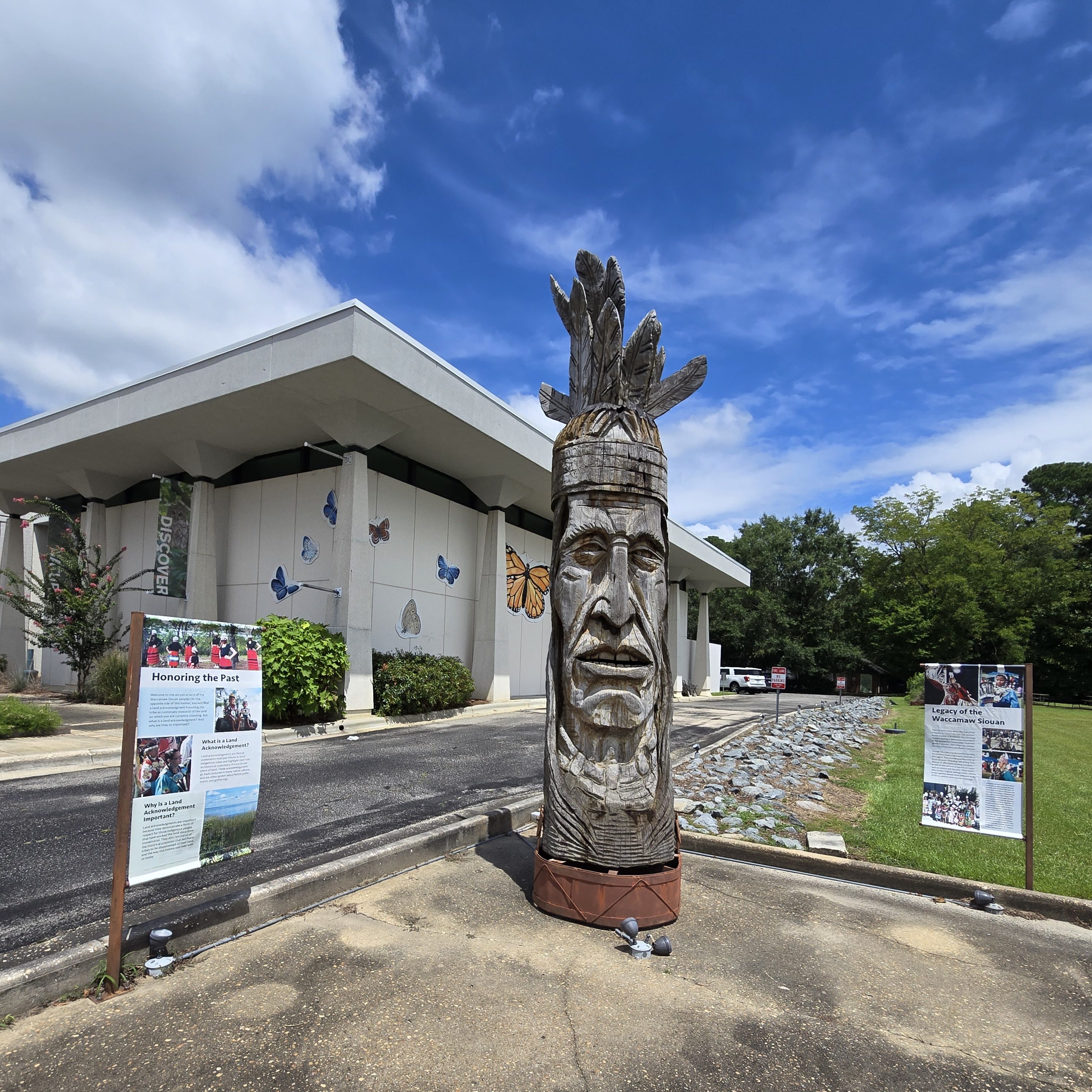
Annual events include the North Carolina Pecan Harvest Festival. In addition, the state-recognized Waccamaw Siouan tribe holds an annual powwow in October with numerous public events.
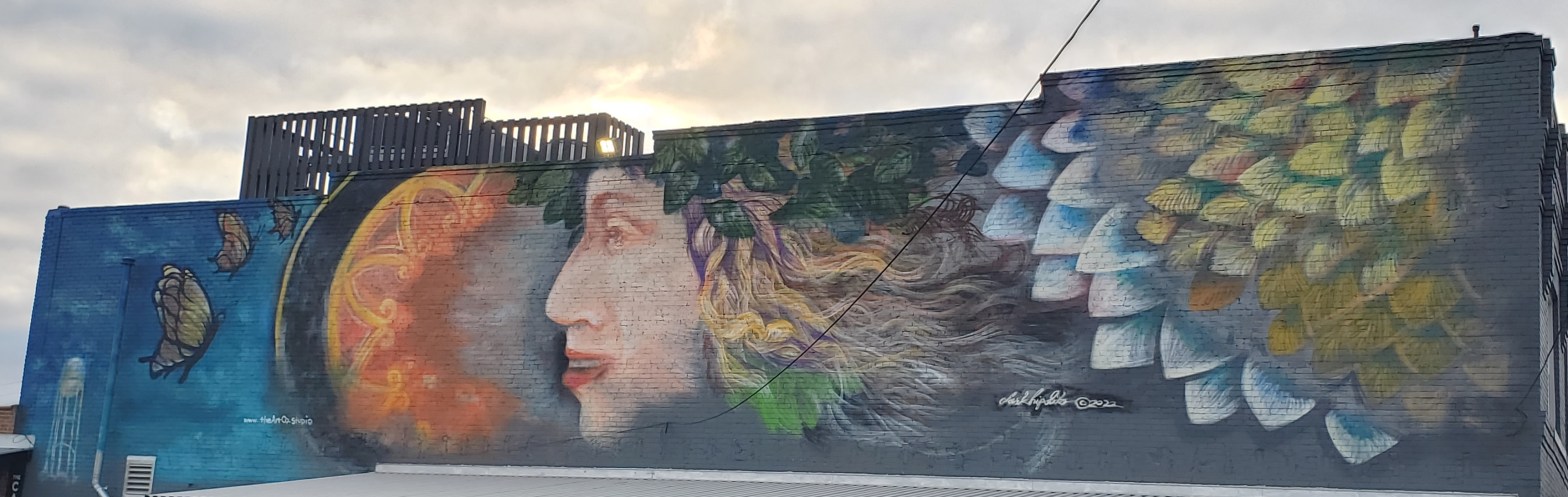
While in Whiteville, take a scavenger hunt around town and see if you can find all 10 of the butterfly murals in town — all painted by local artist Bess Hinson Taylor.
North Carolina Museum of Natural Sciences at Whiteville Whiteville is home to the North Carolina Museum of Natural Sciences at Whiteville (415 S. Madison St.), a satellite museum of the North Carolina Museum of Natural Sciences. Inside and outside, visitors can discover through a fossil lab, investigative lab, naturalist center, discovery forest, and more.
Lake Waccamaw
The town of Lake Waccamaw hosts both year-round residents and vacationers and provides many recreational activities, such as birdwatching and hiking, due to the large population of wildlife and mild terrain. Originally home to Native Americans, Europeans later colonized Lake Waccamaw in the 18th century. The Europeans built naval stores and the discovery of turpentine oil led to the Wilmington-Manchester railroad track. The town surrounds Lake Waccamaw, which features 9,000 acres of diverse wildlife and is a major source of revenue for the town. In 2018, a 40-year ban on hunting alligators was lifted.
Lake Waccamaw and the nearby city of Flemington grew slowly with the help of the Wilmington-Manchester railroad, which brought the rural town access to the world. On January 26, 1869, Charles Oscar Beers started his shingle industry along the southern shore of Lake Waccamaw. This shingle company is famed for having supplied the shingles for Mt. Vernon.
Another company also started south of the lake by Henry Bascom Short after Beers started his company. These two companies came together and formed a new company named Short and Beers, which brought more business to the town and created more jobs. Over time, the company went from producing shingles to becoming the North Carolina Lumber Company.
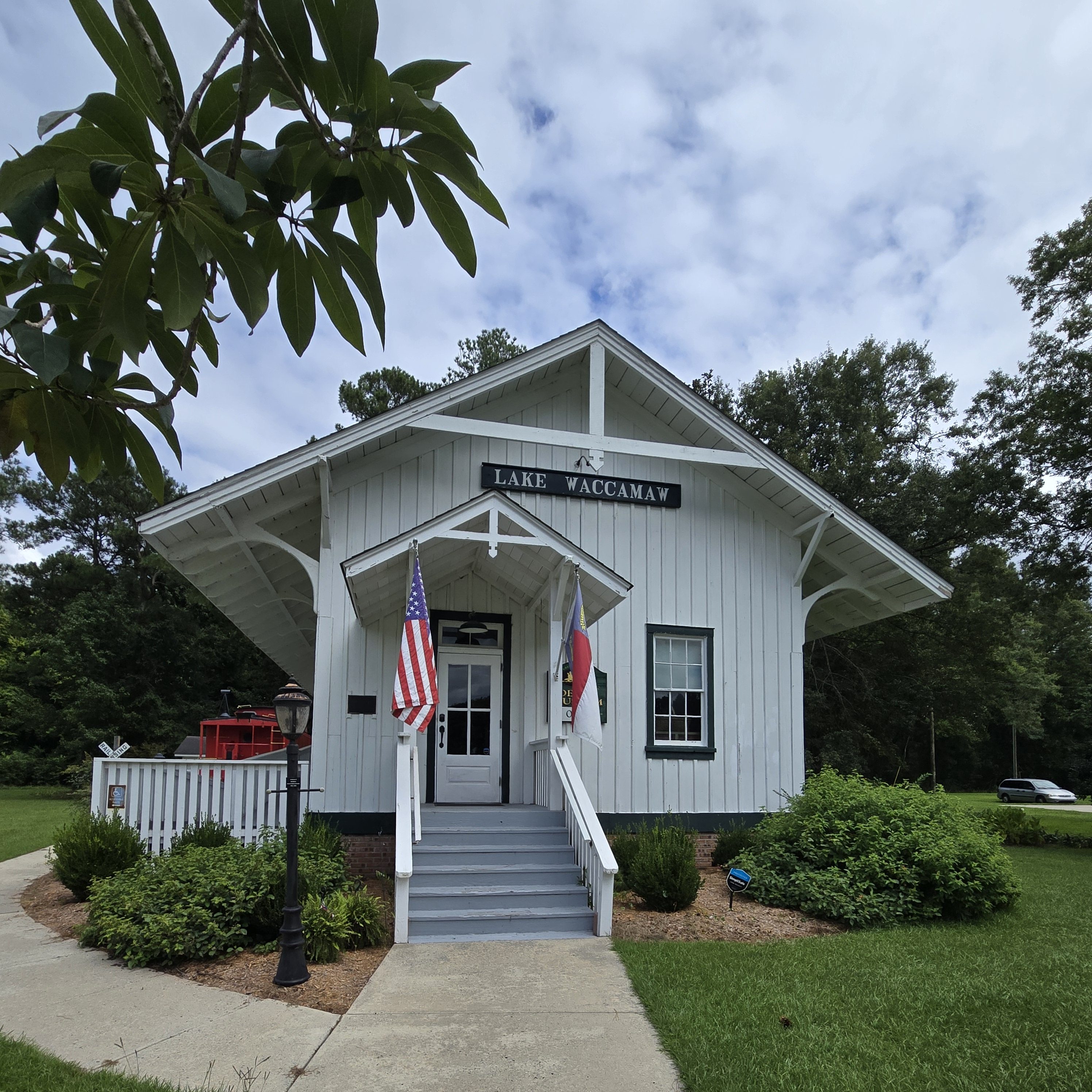
Around 1910, a local group formed the Waccamaw Club. The club served as a gathering place for hunting parties and house parties. The club later disbanded, and the building then became the Waccamaw Hotel. The Lake Waccamaw Depot was listed on the National Register of Historic Places in 1983. The Waccamaw Dam was built in 1926 by the state to prevent the lake from shrinking in dry weather. In 2018, a new bridge that goes over the Waccamaw Dam was finally finished and open for locals.
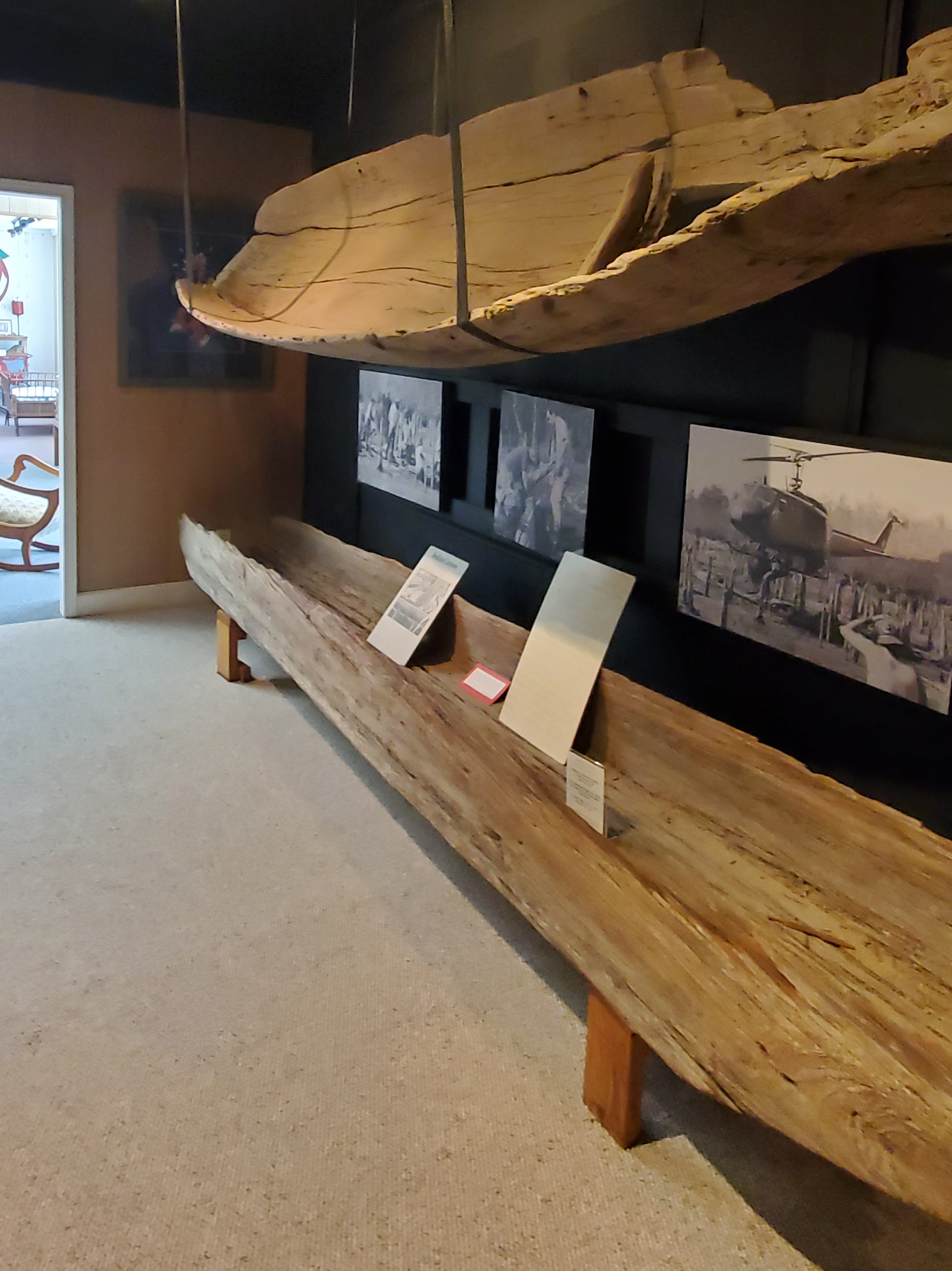
Lake Waccamaw Depot Museum While in Waccamaw, stop by the quaint Lake Waccamaw Depot Museum (201 Flemington Dr.), built in 1904, for a peek back into the area’s history, including actual shingles from the local shingle maker as well as a hand-carved, 300-year-old Native American canoe, which was unearthed from the depths of Waccamaw Lake. Inside, you’ll also find a gift shop and outside a restored red caboose.
Lake Waccamaw State Park
Lake Waccamaw State Park (1866 State Park Dr.) preserves an aquatic system that contains a number of endemic mollusks and fishes found nowhere else on earth! Five species of the state’s rare plant list can be found in the area. And the American alligator also calls the area home. Interestingly, most of the area lakes are quite acidic, but an exposed limestone foundation keeps lake Waccamaw at a nearly neutral pH level. Stop in the visitor center to see the nature displays and the hand-painted mural showcasing 57 of the area’s flora, fauna, and bird and animal wildlife. The mural was painted by local artist Bess Hinson Taylor (the artist that painted all of the butterfly murals in Whiteville) and is dedicated to the memory of Lake Waccamaw State Park Ranger Emily Rebecca Perry, who died by suicide on May 11, 2024. Walk the many trails, including several boardwalks that take you into the surrounding wetlands and to the lake’s edge.
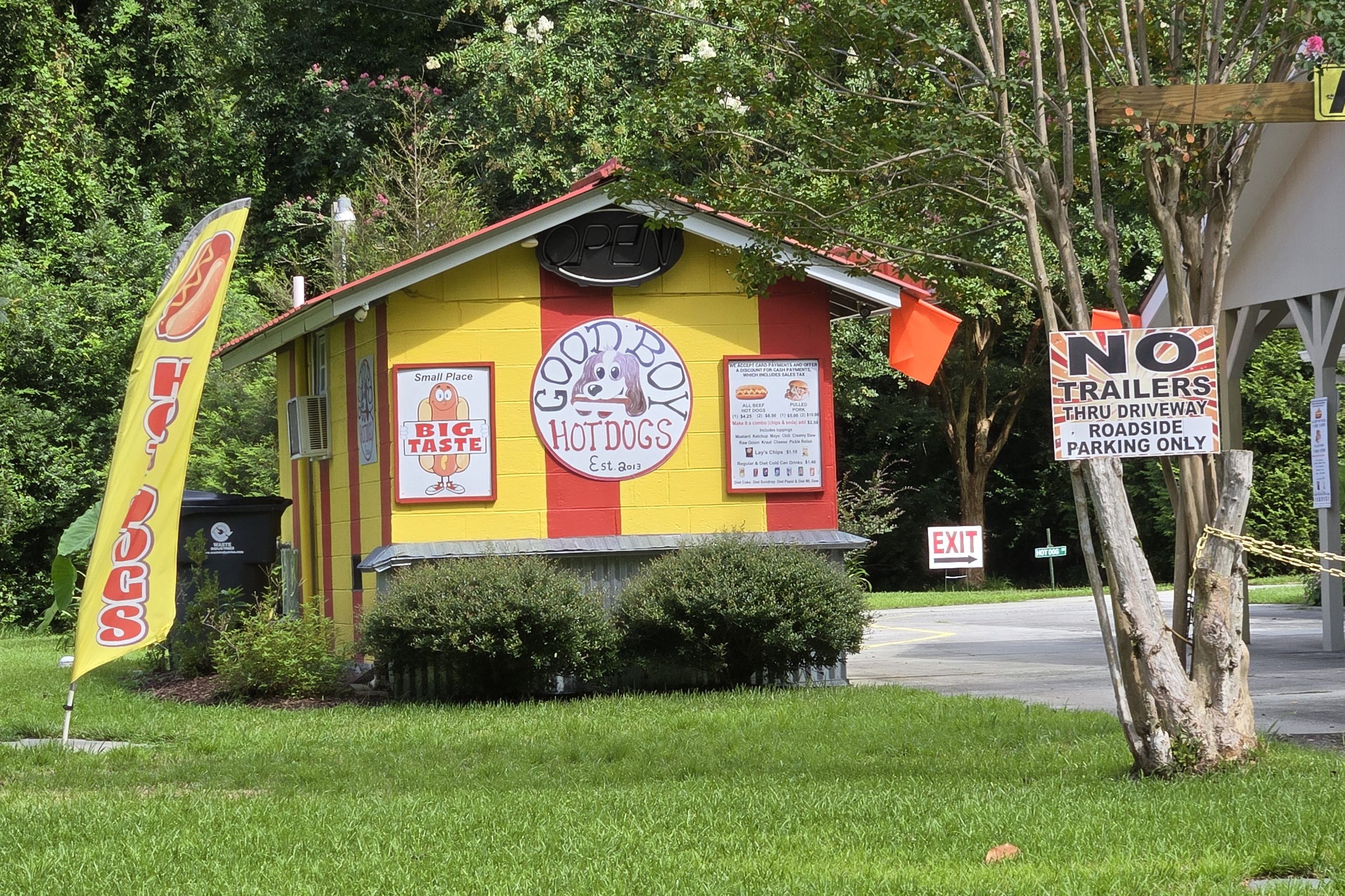
Delco
When passing by or through Delco, stop by for a bite at Good Boy Hotdogs (25985 Andrew Jackson Hwy E.), located right at the side of the road. You can’t miss the yellow signage!
Riegelwood
On November 16, 2006, at 6:21 am EST, a severe thunderstorm warning was issued for eastern Columbus County. At 6:29 am, a tornado warning was issued for the same area. At 6:37, an F3 tornado struck a mobile home park and killed eight people, including two children: Danny Jacobs, 6, and Miguel Martinez, 13. Altogether, 20 people were injured. The tornado was a part of a 3-day tornado outbreak in the South, in which four other deaths were reported. Riegelwood was one of the hardest hit areas.
On Friday, November 17, 2006, a NOAA National Weather Service storm survey team assessed the tornado damage and rated it at F3 on the Fujita scale for nearly a mile in Riegelwood, with winds approaching 200 miles per hour. The maximum width of the tornado was 300 yards where the F3 damage occurred. The rest of the 7-mile damage path was less than 100 yards wide and rated at F1, with winds less than 100 mph extending north across Columbus County into western Pender County. The Columbus County sheriff reported 30 homes destroyed in the F3 damage area. Another three structures were damaged in Pender County, just west of Currie.
Bertie County was first formed as Bertie Precinct in 1722 from the part of Chowan Precinct of Albemarle County lying west of the Chowan River. It was named for James Bertie, his brother Henry Bertie, or perhaps both, each having been one of the Lords Proprietors of Carolina.
In 1729 parts of Bertie Precinct, Chowan Precinct, Currituck Precinct, and Pasquotank Precinct of Albemarle County were combined to form Tyrrell Precinct. With the abolition of Albemarle County in 1739, all of its constituent precincts became separate counties. As population of settlers increased, in 1741 parts of Bertie County were organized as Edgecombe County and Northampton County. Finally, in 1759 parts of Bertie, Chowan, and Northampton counties were combined to form Hertford County. Bertie’s boundaries have remained the same since then.
This mostly rural county depended on an agricultural economy well into the 20th century. In the colonial and antebellum eras, tobacco and cotton were the chief commodity crops, worked by both Indian and African slaves. After the Civil War, agriculture continued to be important to the county.
Merry Hill
Merry Hill is a rural unincorporated community located in Merry Hill Township. Salmon Creek twists and turns through the wooded area of Merry Hill and opens up to the Albemarle Sound. This is known as the Mouth of Salmon Creek. Scotch Hall Preserve in Merry Hill, built in 2009, overlooks the Mouth of Salmon Creek and was designed by retired professional golfer Arnold Palmer.
Most of the history took place in the southern part of Merry Hill known as Avoca. Avoca is Indian for “Meeting of the waters.” The Merry Hill area is comprised of land between Black Walnut Swamp and the mouth of Salmon Creek.
In May 2012, the British Museum in London discovered evidence that the famed Lost Colony was planned to move to a fort in Avoca. Horse racing took place here and many years later this sport was one of the annual social events. There are many old pecan trees planted in the 19th century that still survive in the area.
Colerain Colerain, North Carolina, was named after Coleraine in Ireland. On April 16, 2011, the western side of the town was hit by an EF3 tornado that killed 12 people and caused extensive damage.
Windsor
Windsor is the county seat of Bertie County. The land was historically the home of the Tuscarora people. Today, there are Tuscarora residents living in the village of Tandequemuc, now called Merry Hill.
In the early morning hours of August 4, 2020, an EF3 tornado spawned by Hurricane Isaias struck areas just outside of Windsor. The twister destroyed 12 mobile homes within a mobile home park outside of town, and flattened another poorly built house. The tornado killed 2 people and injured 14 others. The tornado was the strongest tropical cyclone-spawned tornado since 2005.
While in Windsor, be sure to check out the various murals, including one large mural called ‘Lift,’ as well as Artisan’s Alley, located adjacent to 122 S. King St.
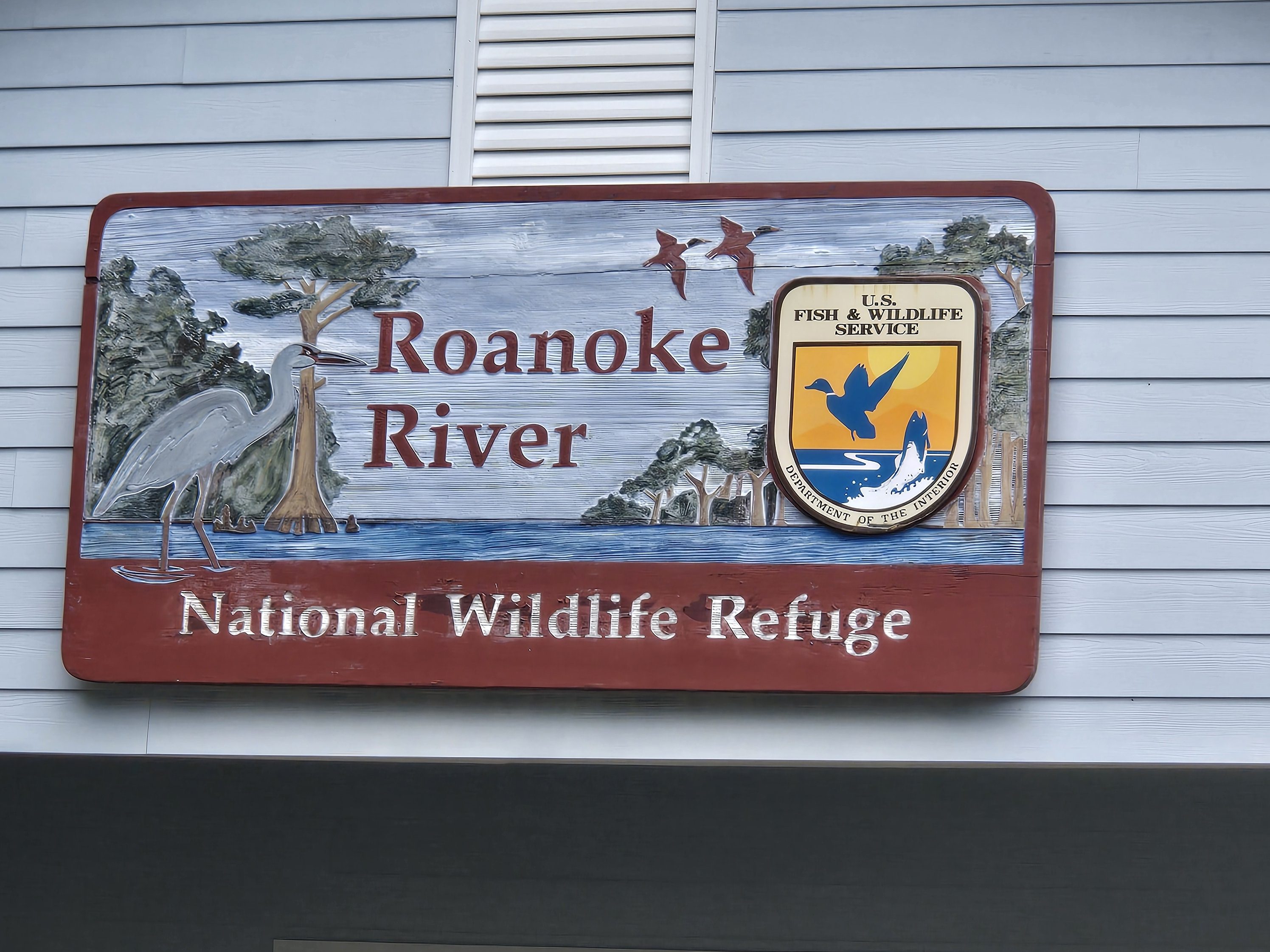
Roanoke River National Wildlife Refuge/Roanoke/Cashie River Center 112 and 114 West Water Street
Livermon Park & Mini Zoo 103 N York St, Windsor
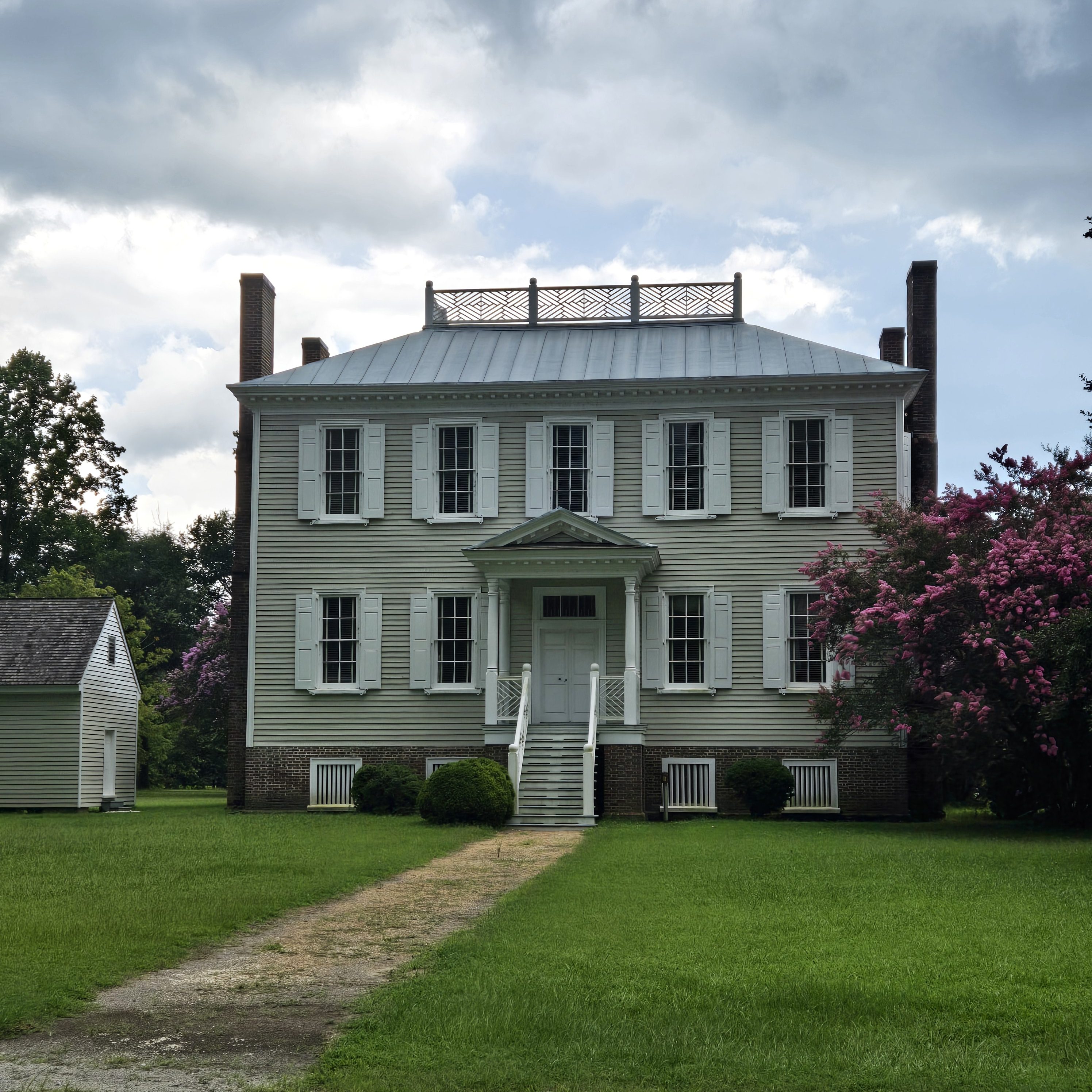
Historic Hope Plantation 132 Hope House Rd
Lewiston Woodville
Lewiston was named for an early settler, and formed from the formerly separate towns of Lewiston and Woodville that merged on July 1, 1981. Lewiston Woodville is also the location of Perdue Farms, one of the largest chicken-producing companies in North Carolina.
Roxobel
Roxobel, a town in northwestern Bertie County, dates to 1724 and was originally known as Cotten’s Cross Roads. After several name changes, it has remained Roxobel since 1849.
Around 1815 William Britton, a successful merchant and farmer from Petersburg, Virginia, moved into the area and purchased the general store. By 1819 he had taken over the post office. The town then became known as Britton’s Store or Britton’s Cross Roads. This name was considered by the post office to be too similar to Britton’s Neck in South Carolina and so in December 1847 the town was renamed Roxobel after Mary Martha Sherwood’s popular 1831 novel Roxobel.
By 1830, the Roanoke River had been made navigable for steamboats and with the small landing stage of Norfleet’s Ferry just two miles south of Roxobel, which spurred the town’s growth as a trading center. Roxobel became connected by rail when the Roanoke and Tar Railroad was opened in 1888 and this brought renewed prosperity to the town.
In 1943 a tornado ripped through Roxobel, killing six inhabitants and causing massive damage. Twenty-five homes and 12 store buildings were completely destroyed and the Methodist church was lifted several hundred feet into the air and smashed to the ground. Around 50 other buildings were badly damaged. Later tornadoes in 1984 and 1988 caused similar destruction.
Named for Josiah Martin, the last royal governor of North Carolina (1771–75), Martin County was formed in 1774 from the southeastern part of Halifax County and the western part of Tyrrell County.
Wilber Hardee, the founder of Hardee’s is from Martin County.
Parmele
The town was settled in 1890 when the Wilmington and Weldon Railroad was built through the area to provide transportation from nearby lumber mills. It was named for local lumber mill owner E. A. Parmele. Following the construction of the Albemarle and Raleigh Railroad, the population rapidly grew, and the community was incorporated as a town in 1893 by the North Carolina General Assembly. A fire burned through much of the town on April 1, 1904, destroying many businesses and leading to the decline of nearby lumber mills. In 1909, William C. Chance founded the Higgs Industrial School for African Americans (also known as the Parmele Industrial Institute) which, at its peak, occupied a six-building campus and merged with the town’s public school. The school was closed following a fire at its main building in 1954.
Robersonville
Robersonville, incorporated in 1872, is located in North Carolina’s Inner Banks region. Once an affluent eastern North Carolina community, it is noted for its abundance of historic mansions and estates, due in large in part to families obtaining wealth from the tobacco industry and then later manufacturing.
The earliest known residents of the Robersonville area were the Tuscarora and Morotock Native American people. According to various deeds, family bibles, wills, and church records, European settlers arrived many years before the Revolutionary War. One of the earliest known churches of the area was Flat Swamp Primitive Baptist Church, founded in 1776. Among the early settlers of this area was the family of Henry Robason, who is said to have been born in 1710 in England. Eventually the family name became “Roberson,” and the family tree grew throughout the region. Before the Civil War, George O. Roberson and his father, William, owned a store originally located on the northwest corner of what are now Railroad and Roberson streets. The local militia trained at this store during the Civil War.
When the town was incorporated February 16, 1872, it became the first town in Martin County not located on the Roanoke River; thus, it wasn’t dependent on the river for communication with other settlements. Instead, the railroad was the main artery of communication and trade. The town was named after Henry, William, and George Roberson. Of the three brothers, Henry D. Roberson is considered to be the “Father of Robersonville.”
In the late 1800s, the Jewish Agricultural Society helped many Jewish families relocate from Russia to the United States. While most of these families settled in the Northeast, a few were relocated to eastern North Carolina due to its agrarian-based economy and abundance of affordable land. Most notably the Margolis, Smith (Schmidt), and Bernstein families came to the Robersonville area in the early 1900s and took to farming in addition to owning department stores and shops. In 1902, Adath Shalom (Congregation of Peace) was established. The first synagogue was built in 1907 and existed until it caught fire in the late 1940s. Afterward, most families attended religious services in nearby Rocky Mount, 34 miles (55 km) to the west. The handful of Jewish families who resided in Robersonville and nearby Williamston either died or relocated to larger cities, with the Margolis family being one of the last to leave in the 1990s.
Everetts
Incorporated in February 1891, Everetts was named for a family of first settlers and was a thriving trading center situated along the railroad between Robersonville and Williamston. It began more than 20 years earlier as a small rural cross roads named for its principal landowner, Simon Peter Everett. In 1869, he deeded some of his land to the Williamston and Tarboro Railroad Company for the construction of the railroad.
After October 1882, when the Seaboard and Raleigh Railroad, the successor to the Williamston and Tarboro, finally completed the rail line, the Everetts community began to develop as a market for agricultural products such as cotton, corn, grapes, potatoes and eventually peanuts. It grew into a trading center for much of Cross Roads and Poplar Point townships for farm and household supplies. The railroad, with its mail, passenger, and freight services and telegraph line, was the lifeline of the community. Today, visitors can see the landmark J.T. Barnhill Building along US Business 64/13, which still serves as a general store and has a painted billboard on its outside wall.
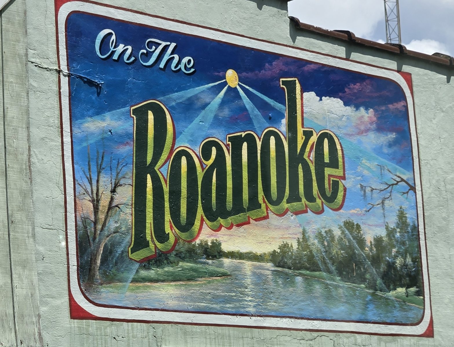
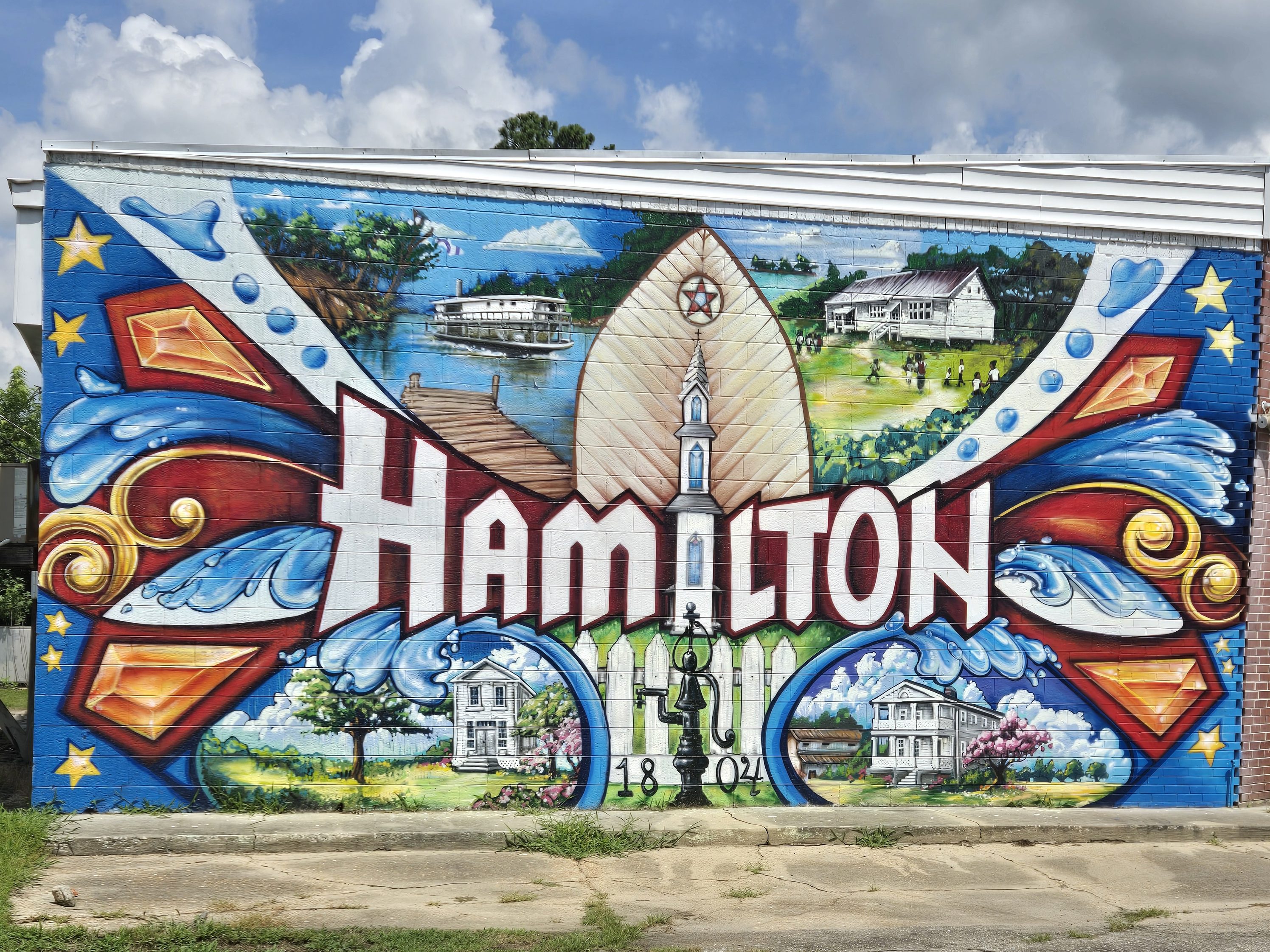
Hamilton
The town was founded in 1804 at the highest point of navigation on the Roanoke River.
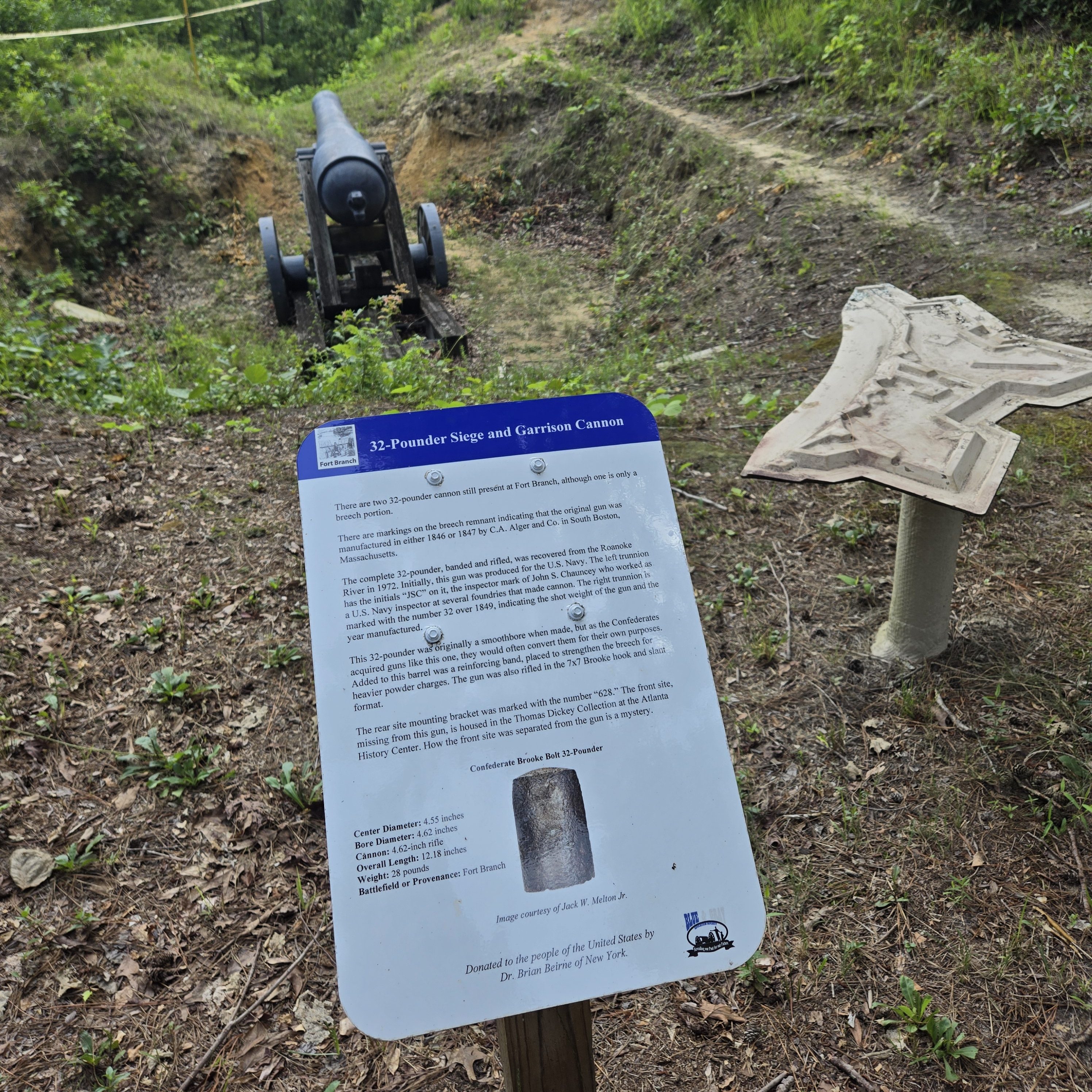
According to local historians, the most significant historical event of early Hamilton was the battle and fall of Fort Branch during the American Civil War, when Union vessels and troops came upriver from Plymouth in an attempt to reach Weldon to cut off supplies to General Robert E. Lee. The fort, located two miles southeast of Hamilton along the Roanoke River, protected Weldon until the day after General Lee surrendered at Appomattox Court House, whereupon the railroad line over the Weldon bridge had no more military significance. Afterward, the fort was abandoned and the cannons were dumped into the Roanoke by departing Confederate troops.
In 1887, the town saw construction of its first railroad, the Hamilton Railroad & Lumber Company, also known as Hitch’s Railroad. This was a short line that served the lumber industry in the area, but later expanded operations. In the 1910s, a Rosenwald school was constructed in Hamilton to serve the local black community. Alternating dates of construction are reported, with the earliest being 1914. The school operated until 1960.
Hamilton, once a thriving, beautiful Victorian port town with many of its homes listed in the National Historic Registry, has been in decline in recent years, losing more than half its population since 1980.
Fort Branch Civil War Site Located just past Hamilton, The Fort Branch Civil War Site (2883 Fort Branch Rd.), is worth a visit and self-guided tour.
In July 1972, a group of men from Alabama began pulling cannons from the river. In an effort to keep the cannons in Martin County, the group was accused of violating North Carolina’s antiquities laws. The courts officially decided that the cannons belong to the state under the North Carolina Department of Archives and History. The department decided to permanently loan the artifact to Fort Branch.
Another important site in Hamilton is the Rosenwald School, a black school funded by Julius Rosenwald, president of Sears, Roebuck and Co. During segregation, white schools had approximately five times the funding of the former. The Rosenwald Fund sought to provide support for these underprivileged schools.
Williamston
Founded in 1779 and named after Williams William, a local military commander during the American Revolution, Williamston is the county seat of Martin County.
Williamston was a focus of activity in the Civil Rights Movement. Beginning in June 1963, civil rights activists led by Golden Frinks protested at City Hall for 29 consecutive days. The Ku Klux Klan was very active in this part of the state during this time, including a well-documented rally in Williamston on October 5, 1963, attended by mostly local residents but with several carloads of attendees traveling over 150 miles to attend.
Moratoc Park Moratoc Park (102 River Dr.) is a lovely 18-acre riverside park, located beside the Roanoke River. The park features a river overlook and a newly constructed riverside walkway. The park also features a river overlook, fishing pier and canoe/kayak launch, and the Moratoc building, a rustic conference building overlooking the scenic Roanoke River. Moratoc Park is the site of the original wharf of Williamston, where goods were shipped in and out.
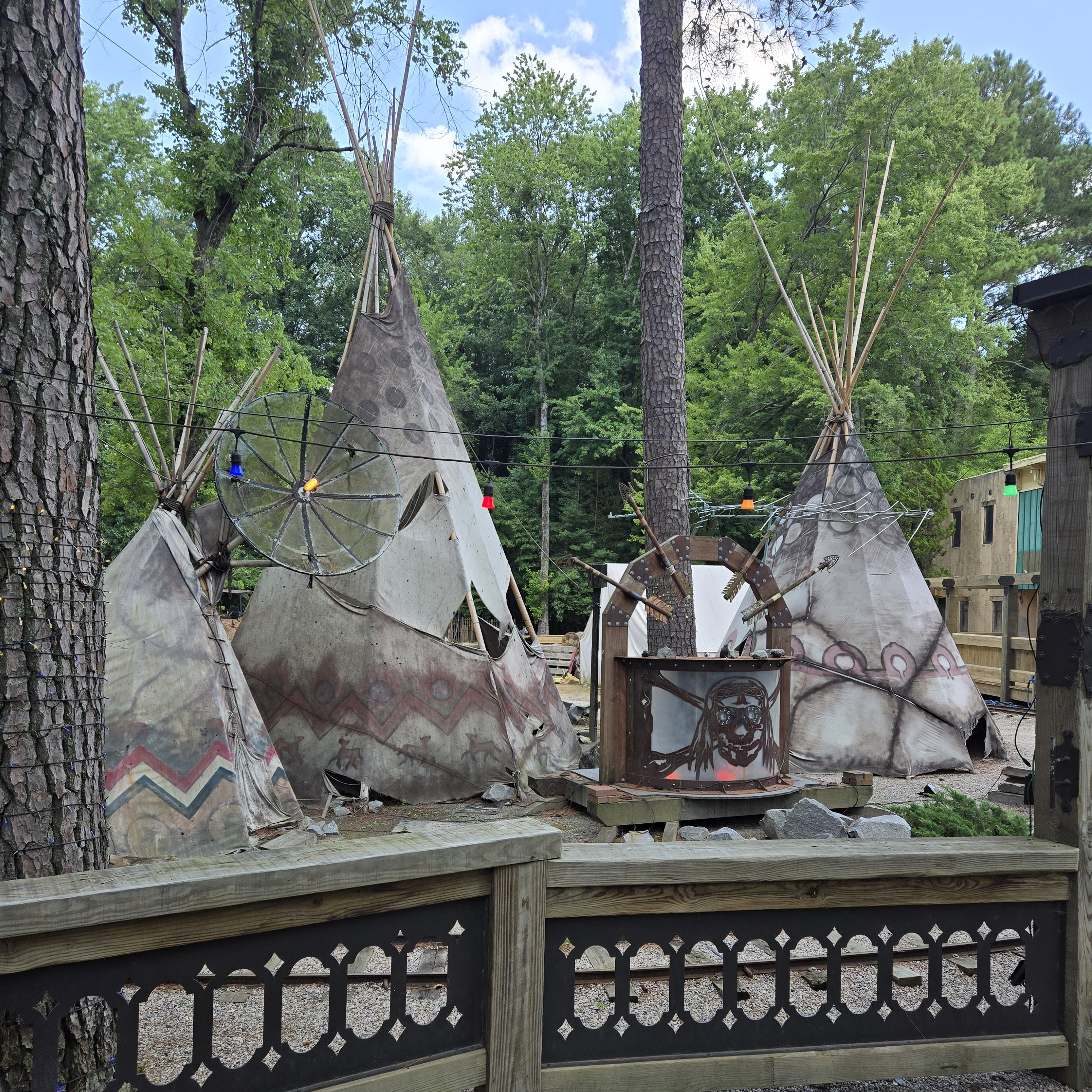
Deadwood Restaurant and Theme Park Located south of Williamston and near the town of Bear Grass (2302 Eds Grocery Rd.), the Deadwood Restaurant and Theme Park is a family-owned and operated Western Theme Park featuring scenic train rides, miniature golf, arcades, playground, roller coaster, carousel, picnic areas, ice cream and coffee shop, a full-service restaurant, and a large indoor area that features a dinner theater, a haunted house for Halloween, and a banquet hall for private parties. Outside of peak hours, you can enter the park to walk through.
Bear Grass
The town of Bear Grass, located in the southern part of Martin County, was named for a type of yucca (Yucca flaccida) that grows less than two feet in height and is found abundantly in the region. The community’s development was hindered by it not being located along a navigable stream or on either of the railroad lines traversing Martin County. A post office was established in 1885, although it was closed less than two years later.
Records are limited, complicated by the fact that Bear Grass businesses were listed in directories with Williamston addresses because that was the nearest post office. But by the turn of the century, the community consisted of several legal distilleries, cotton gins, sawmills, grist mills and blacksmith shops. Reuben H. Rogerson’s two-story steam-powered sawmill and cotton gin was one of the area’s largest before being destroyed by fire in November 1908.
The first decade of the 20th century witnessed considerable growth in the community. After several meetings in early 1909, the town’s merchants drew up a charter, and on February 16, 1909, the North Carolina General Assembly granted a charter to the town of Bear Grass.
An unusual physical feature of the town is that, when incorporated, the boundary was a circle with a radius of 500 yards from a white oak “near a well at the stores of Rogers Brothers and Cowing Brothers.” These limits remain today, making Bear Grass one of the few towns in the state laid out in this manner.
Local artist Henry C. Cowen created two statues that enliven the Bear Grass School campus. The “rampant bear” statue standing in front of the school was sculpted in 1981. The statue of George Washington in front of the Yucca House (formerly the Bear Grass School teacherage) was commissioned by the Bear Grass Ruritan Club in honor of the country’s constitutional bicentennial in 1987. Cowen also produced several war memorial soldiers located on the corner of Green Street and Ayers Avenue.
Beginning in 2014, Bear Grass hosts the annual Chicken Mull Festival. Chicken mull is a local comfort food consisting of parboiled chicken, broth, crushed soda crackers, chopped boiled eggs and seasoning. The festival is held each year in the fall.
Jones County is the fourth-least populous county in North Carolina. Its county seat is Trenton. There are only three incorporated towns in Jones County: Pollocksville, Trenton, and Maysville.
The area eventually encompassing Jones County was inhabited by Tuscarora Native Americans before the arrival of German and Swiss settlers in the early 1700s. The county was formed in 1779 from the southwestern part of Craven County. It was named for Willie Jones, a planter, slaveholder, Revolutionary leader, and president of the North Carolina Committee of Safety during the war. He opposed state ratification of the United States Constitution and did not attend the Fayetteville Convention, which voted to ratified it. In 1784, the town of Trenton was made the county seat of government.
The rural Low Country county was originally developed for plantations, which were dependent on the labor of enslaved African Americans. The county’s has heavily relied on agriculture (mostly tobacco) and lumber from its nearby forest.
Pollocksville
A quiet, agricultural town, Pollocksville derives its name from Thomas Pollock, a local landowner. Once prosperous for lumber milling, the town still maintains its rich architectural history nestled alongside the natural beauty of the Trent River. Pollocksville is a Bird Sanctuary and welcomes any aviaries. The Town boasts nearby fields of corn, soybean, and cotton, surrounded by the dense pines of the Hofmann Forest to the East, and the Croatan National Forest to the West.
In Pollocksville, you’ll find the Foscue Plantation and the Things From Yesteryear Museum (4187 Ten Mile Fork Rd.).
Maysville
At first, the Maysville area was known as Young’s Cross Roads, named after one of the prominent residents who lived along the river, Mr. John Young. Upon his and his wife Nancy’s death, his children sold their land and the town became known simply as the “Crossroads.”
In the late 1800s, the town took its present name of Maysville from the John D. May Family. Mr. May was instrumental in getting an elementary school established on the Jones County side of the river and he taught at this school. The new school was also used as a place of worship. The school was referred to as May’s School from the very beginning, and as time passed the entire settlement became known as Maysville. Maysville became incorporated as a town on March 9th, 1897.
Maysville was one of the first towns in North Carolina to elect a woman as mayor. In 1925, Mrs. Annie Koonce Jenkins was elected and served six years as the Mayor of Maysville. Today her legacy is still seen by all because she was responsible for planting the large oaks, many of which still line the city streets today.
Duplin County was formed in 1750 from New Hanover County. It was named for Thomas Hay, Viscount Dupplin (later 9th Earl of Kinnoull), as he was known when he served on the Board of Trade and Plantations in England in the 1740s. In 1784, the western part of Duplin County became Sampson County.
The county’s tag line is Uncork. Unwind. Unplug., surely a reference to the county’s famous Duplin Winery as well as its many rural and recreational areas as well as parks and golf facilities.
Caleb Bradham (1867–1934), an American pharmacist born in Chinquapin, is best known as the inventor of the soft drink Pepsi.
Ruth Faison Shaw (1889–1969), an American artist and educator born in Kenansville, is credited with introducing finger painting into the United States’ education system.
William Thornton, born in Duplin County, was North Carolina’s first astronaut, flying on two Space Shuttle Challenger missions.
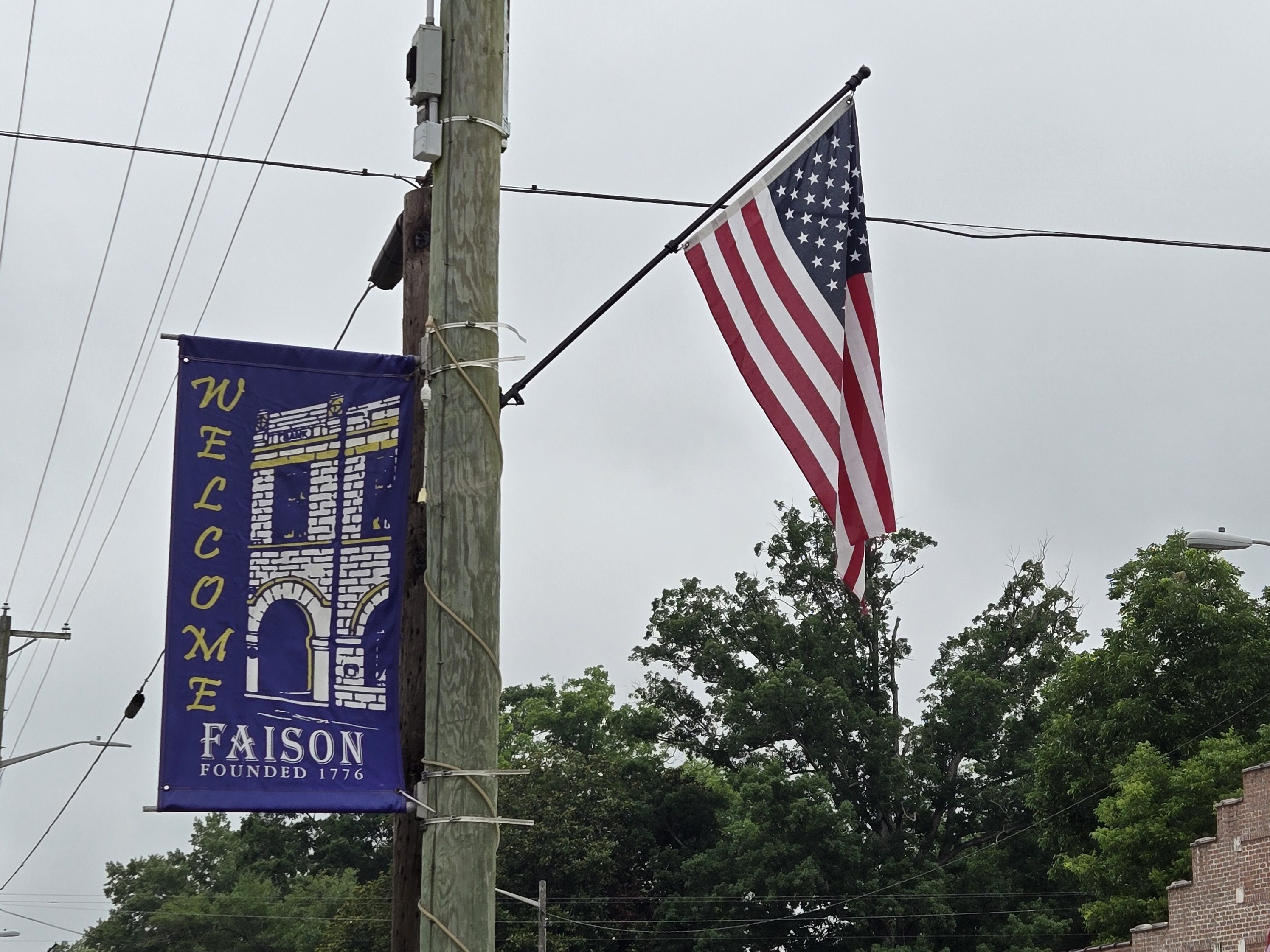
Faison
Faison was originally called “Faison’s Depot,” and under the latter name was founded around 1833. The town was named for Henry Faison, the original owner of the town site.
In the late 1800s and early 1900s, Faison’s strategic location along the Wilmington to Weldon railroad made it a major center for agricultural commerce and shipping point for agricultural products, by rail, to northern cities. In the mid-1900s, farmers from miles around, would bring their products to the Faison Produce Market, to be auctioned/sold and shipped, mostly by truck, to northern markets.
Today, Faison has emerged as an international exporter of food products. Major agribusinesses include, Bay Valley Foods, Southern Produce Distributors, Cottle Farms, and Burch Farms. The original Faison Depot Train Station (c. 18880 was moved to the Town Park and today serves as a Public Library and Public Museum. You’ll also find the Faison Museum here (106 Park Circle), housed within the town library (and old train depot).
The Faison Area also claims more than 700 veterans from all wars.
Warsaw
Warsaw is the home of the oldest Veterans Day celebration in the USA, and they hold an annual Veterans Day Parade each November.
Duplin County Veterans Museum The Duplin County Veterans Museum (119 E. Hill St.) is located in the historic L.P. Best House, a beautifully restored Queen Anne/Neo-Classic-style house in the Warsaw National Register Historic District (built in 1894). The museum houses military artifacts and memorabilia from many periods in military history displayed primarily on the second floor. The first floor is a restored tribute to the L.P. Best family. The museum is only open for restricted hours or by appointment, so check ahead to schedule your visit.
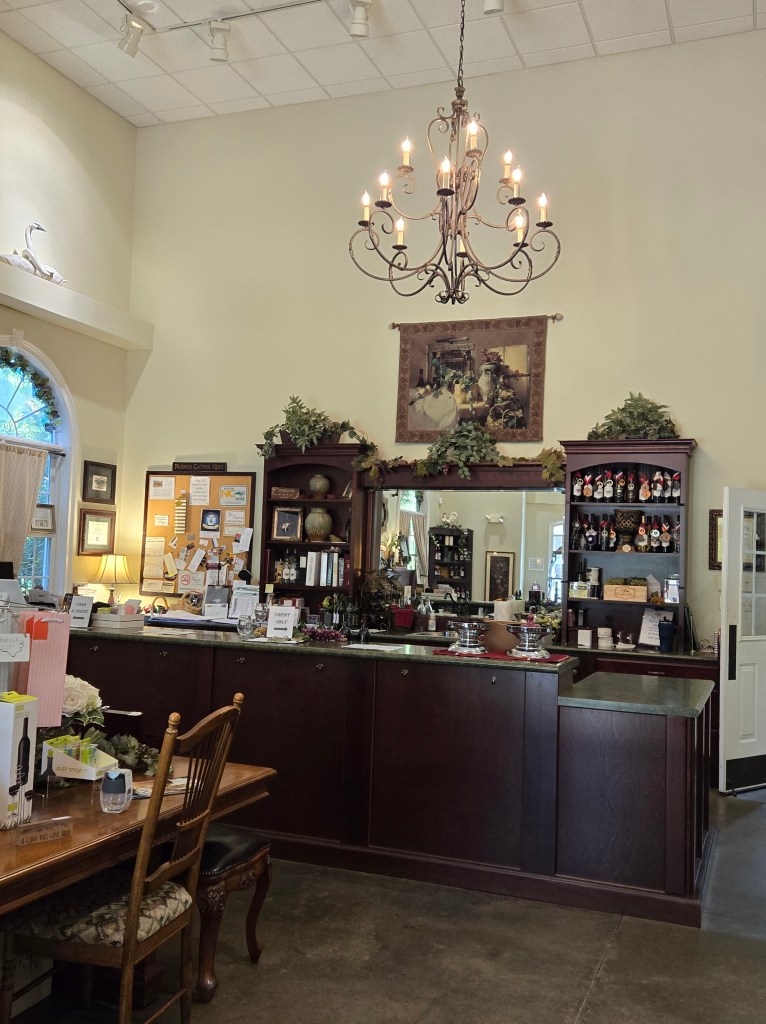
Country Squire Winery Within Warsaw’s district, you’ll also find the classic Country Squire Winery Restaurant & Inn (748 NC HWY 24/50), which was the place to be seen back in its heyday. However, the restaurant still fills up for dinner, especially on the weekends. It is quite a unique place with a rustic interior and actual tree trunks left inside throughout its various dining spaces. After dinner or a wine tasting, stop by the gift shop. And you can even check in to stay at their inn next door. The venue also hosts weddings, special events, and business group meetings.
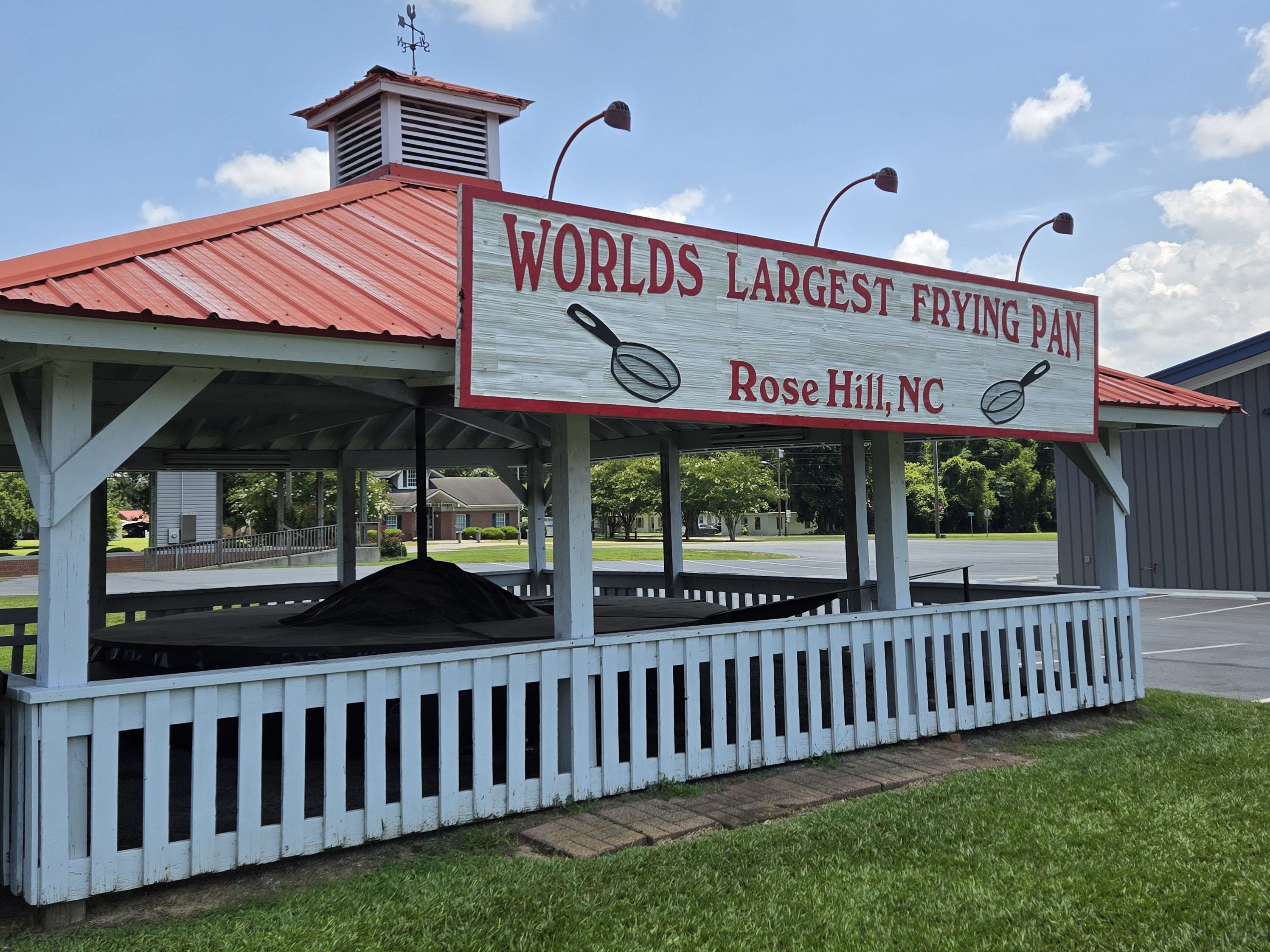
Rose Hill
The town of Rose Hill was named for the abundance of wild roses near the original town site. You’ll find two must-see attractions in this small, rural community. Rose hill hosts the annual Grape Stomp as well as the NC Muscadine Festival, both in September each year.
Duplin Winery Duplin Winery (505 North Sycamore St.) is boasted as North Carolina’s first and oldest winery — and the largest winery in the South. The winery makes award-winning Muscadine wines, including reds, whites, blushes, specialty wines, alcohol-free wines, and frozen Sweezers. They also have an extensive gift shop. You’ll find additional locations in N. Myrtle Beach and Panama City, FL.
World’s Largest Frying Pan You can’t pass through Rose Hill or Duplin County without stopping at this roadside attraction — The World’s Largest Frying Pan (510 E. Main St.). It is viewable by the public at any time day or night. The frying pan, used only once each year during the NC Poultry Jubilee, holds 200 gallons of oil and can fry more than 300 pieces of chicken at one time!
Wallace
Wallace is a small town that straddles both Duplin and Pender counties. The town of Wallace was first known as Duplin Crossroads and was incorporated into existence in 1873. Later in 1899, the town fathers decided to adopt the new name, Wallace, to honor Stephen D. Wallace, an official of the Atlantic Coast Line Railroad. Wallace is Duplin County’s largest population and retail trade center serving over 50,000 people in a surrounding three county area. The town holds the Carolina Strawberry Festival on the first weekend in May each year and the Backstreet Music Festival in August. Here, you’ll find the Thomas C. Townsend Fireman’s Museum (316 Murray St.) and the Wallace Train Depot (206 Southwest Railroad St.) as well as some nice downtown shopping and restaurants, including the Pink Willow Boutique.
Chinquapin
The roots of Chinquapin, North Carolina lie largely with the Thigpen family, who migrated to the area from Perquimans Precinct in the 1730s. Chinquapin has always been a predominantly agrarian community focused around the cultivation of corn and (to a lesser extent now) tobacco. Raising livestock and harvesting timber/naval stores has also been an essential component of the local economy for centuries. Before the railroad, the only feasible method for these commodities to reach the market (namely that of Wilmington) was via river. Ideally located near the N.E. Cape Fear, Chinquapin was oftentimes the port of departure for produce in eastern Duplin County, especially at times of low water levels when sites further upriver were not accessible. Throughout the early 19th century, the plantation at Chinquapin grew from a homestead with a handful of slaves to a community of several dozen people.
In 1865, toward the end of the Civil War, Union troops captured a small steamer named the A. P. Hurt at Fayetteville. They appointed a former slave named Dan Buxton as its pilot and sent it to operate at Chinquapin. After the war, Buxton tracked down the businessmen who had originally owned the vessel and informed them that he considered the A.P. Hurt to still be their property. Buxton promised to return her if they kept him as pilot for life. When she sank in 1923, he was still on the job after sixty years.
Beulaville
Beulaville is the most recent town to be incorporated in Duplin County. The earliest Native Americans thought to have lived in the area were the Joara (whose settlements date back to AD 1000), based out of present-day Burke County. The Joara were the chiefdom of the Mississippian culture. Immediately prior to European colonization in the early 18th century, the coastal plain of North Carolina was home to many distinct Native American tribes: the Coree, Coharie, several small Neusiok communities, and the Tuscarora.
Native American burial mounds are numerous in Duplin County, in the rural areas surrounding Beulaville especially. There are four sizable mounds within a ten-mile radius of the town, the two largest being in the vicinity of Hallsville and Sarecta. Combined, these mounds contain roughly one hundred bodies.
The arrival of the Palatines at New Bern and the ensuing wave of English and Welsh settlers sparked a conflict known as the Tuscarora War (1710–1715). With the elimination of the last Tuscarora stronghold at Fort Neoheroka and subsequent exodus of the remainder of the tribe to New York (they became the sixth nation of the Iroquois Confederacy), the interior of the coastal plain was made available for European settlement. Many of the original European settlers of what is now Beulaville arrived from Beaufort, Craven, Jones, and Onslow counties.
In 1736, Duplin County (then upper New Hanover County) was the destination of several hundred Ulster Scots (Scotch-Irish) and a handful of Swiss Protestants. Beulaville proper was founded as “Snatchet” in 1873 out of necessity for a trading center for nearby farmers and those in the business of logging and turpentine production. Also colloquially referred to as “Tearshirt” by locals, the town was once notorious for alcoholism and frequent street brawls. Indeed, the manufacture and distribution of corn liquor remained a steady source of income for many families well into the 20th century. Upon demolition of a prominent downtown building (which had formerly served as a soda shop in the 1950s) to make way for a McDonald’s, a moonshine still and several barrels of the drink were uncovered in the basement.
Sarecta
Sarecta was the first incorporated town in Duplin County, North Carolina, established in 1787. When Sampson County was created out of a portion of Duplin County in 1784, there was a need to establish a new court house in a more central location. Sarecta and the present location of Kenansville were the two candidates, and General James Kenan (for whom Kenansville is named) cast the deciding vote against Sarecta. By act of the North Carolina General Assembly on January 6, 1787, the town was established under the spelling “Sarecto” and was 100 acres in size including lots and property for a town commons.
Kenansville
Kenansville is the county seat of Duplin County. The town was named for James Kenan, a member of the North Carolina Senate. Liberty Hall (409 S. Main St. — right beside the Cowan Museum), his early-1800s-era historic home, is located within Kenansville. At the time of this visit, Liberty Hall was closed for repairs.
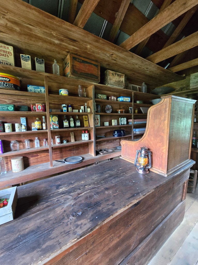
Cowan Museum of History & Science The Cowan Museum of History and Science 9411 S. Main St.) was founded in 1981 by George and Ila Cowan as a memorial to their daughter, Joann Cowan Brown. It is housed within the Kelly-Farrior House (ca. 1848) and has an adjacent historical park with 6 wooden buildings, which include a log cabin, general store, and tobacco barn. Also on the grounds is a botanical garden with approximately 90 species of commercially-available native plants in what has become one of the region’s first free, public native-plant-focused botanical landscape garden. This outdoor space, which is open 24-hours a day, has pollinator gardens, a wet meadow garden, Longleaf Pine upland garden, and a Bald Cypress wetland garden.
Of the 4,300 objects in the collections, about 2,000 were donated to Duplin County by the Cowan family, with most focusing on 19th- and 20th-century tools and technology. Objects on display include a diversity of woodworking tools, gardening tools, agricultural implements, items used in a variety of crafts and trades, medical devices, many household artifacts, and an impressive collection of geological specimens. Unique items may be encountered onsite, such as a 1930s permanent wave machine, an alternative fuel fan, and a hog oiler.
Guilford County is the third-most populous county (and city) in North Carolina behind Mecklenburg County (Charlotte) and Wake County (Raleigh).
The original inhabitants of the area were a Siouan-speaking people called the Cheraw. Beginning in the 1740s, settlers arrived in the region in search of fertile and affordable land. These first settlers included American Quakers from Pennsylvania, Maryland, and New England as well as German Reformed and Lutherans in the east, British Quakers in the south and west, and Scotch-Irish Presbyterians in the center of today’s Guilford County. As the population increased, the North Carolina colonial legislature organized the county in 1771, from parts of Rowan and Orange counties. It was named for Francis North, Earl of Guilford, father of Frederick North, Lord North, British Prime Minister from 1770 to 1782.
The Quaker meeting also played a major role in the European settlement of the county. Numerous Quakers still live in the county. New Garden Friends Meeting, established in 1754 and first affiliated with a Pennsylvania meeting, still operates in Greensboro.
On March 15, 1781, during the American Revolution (1775-1783), for independence from Great Britain, the Battle of Guilford Court House was fought just north of present-day Greensboro between Generals Charles Cornwallis and Nathanael Greene. This battle marked a turning point in the Revolutionary War in the South. Although General Cornwallis, the British commander, held the field at the end of the battle, his losses were so severe that he decided to withdraw to the Carolina coastline, where he could receive reinforcements from the British Royal Navy at the port in Wilmington and his battered army could be protected by the British naval power. His decision ultimately led to his leading his finished ravaged army north into Virginia leading eventually to his defeat and surrender later in October 1781 at Yorktown, Virginia, after a long siege, by a combined force of American and French Royal troops and blockading French Navy warships on the Chesapeake Bay.
In 1779, the southern third of Guilford County was separated and erected as Randolph County. In 1785, following the American Revolution, the northern half of its remaining territory was organized as Rockingham County. In 1808, the town of Greensboro replaced the hamlet of Guilford Court House as the county seat. It was more centrally located, making it a better location for travelers of the time.
The county was the site of early industrial development. In the antebellum era, many of the county’s residents were opposed to slavery, including Lutherans, Quakers, and Methodists. The county was a stop on the Underground Railroad, for which volunteers aided refugee slaves en route to freedom in the North. People gave them safe places to stay and often food and clothing.
Guilford College was founded in 1837 as the New Garden Boarding School; its name was changed in 1888 when the academic program was expanded considerably. Guilford College is now the third-oldest coeducational institution (1954) in the country and the oldest such institution in the South. Greensboro College, established by the Methodist Church through a charter secured in 1838, was also one of the earliest institutions of higher education for women in the United States.
In 1873, Bennett College was founded in the basement of the Warnersville Methodist Episcopal Church (now St. Matthew’s Methodist Church) with 70 African American male and female students. In 1926, the school became a women-only college, as it continues to be today.
In 1891, Greensboro was selected as the home of a land-grant institution for African Americans, the Agricultural and Mechanical College for the Colored Race, now known as North Carolina Agricultural and Technical State University (NCA&T). It was the nation’s second college established under the federal Morrill Act of 1890 and was the first state-supported school for people of color in North Carolina.
Also in 1891, what is now the University of North Carolina at Greensboro (UNC-G), opened as the state’s first and only publicly supported institution of higher learning for women, the State Normal and Industrial School, established in Greensboro especially to train teachers. In 1932, the school joined with the University of North Carolina at Chapel Hill and North Carolina State University in Raleigh to form the Consolidated University of North Carolina; it was renamed as the Woman’s College of the University of North Carolina. From the 1930s to the 1960s, the Woman’s College was the third-largest women’s university in the world. In 1963, the university was changed to a coed institution, and its curriculum was gradually expanded to include graduate work.
Following World War II, African-American veterans and young people heightened their activities in the American civil rights movement. Guilford County was the site of an influential protest in 1960 when four black students from the North Carolina A&T State University in Greensboro started an early sit-in. Known afterwards as the Greensboro Four, the four young men sat at a “whites-only” lunch counter at the Woolworth’s store in downtown Greensboro and asked to be served after purchasing items in the store. When refused, they asked why their money was good enough for buying retail items, but not food at the counter. They were arrested, but their action led to many other college students in Greensboro, including white students from Guilford and the Women’s College, to sit at the lunch counter in a show of support. The students carried on a regular sit-in and within two months, the sit-in movement spread to 54 cities in nine states; Woolworth’s eventually agreed to desegregate its lunch counters, and other restaurants in Southern towns and cities followed suit.
A darker racial incident in 1979 was called the Greensboro massacre. In this incident the predominantly African American Communist Workers Party (CWP) led a march protesting the Ku Klux Klan and other white-supremacist groups through a black neighborhood in southeastern Greensboro. They were attacked and shot at by KKK and American Nazi Party members; five of the Communist Party marchers were killed and seven wounded in the attack. In 1980, the case attracted renewed national attention when the six shooter defendants were found “not guilty” by an all-white jury. None of the people involved in this shooting, from either side, was a citizen of Guilford County; they simply chose the county seat of Greensboro as a rallying point. In 1985, families and friends of the victims won a civil case for damages against the city police department and other officials for failure to protect the African Americans; monies were paid to the Greensboro Justice Center.
Notable people from Guilford County include…
Joseph Cannon, 35th speaker of the United States House of Representatives (1903–1911)
Levi Coffin, abolitionist leader who was nicknamed the “President of the Underground Railroad” for helping escaped slaves to freedom in the North before the Civil War
Dolley Madison, wife of President James Madison and the fourth First Lady of the United States
Edward R. Murrow, American broadcast journalist
William Sydney Porter, short-story writer better-known as “O. Henry”; his most famous story is “The Ransom of Red Chief”
Andrew Jackson, 7th president of the United States
Summerfield
The community that became known as Summerfield traces its roots back to 1769 when Charles Bruce bought 640 acres in what is now the heart of Summerfield. During the Revolutionary War, the Bruce home was the birthplace and muster site for a group of patriots known as the “Friends of Liberty.” During the Revolution, Charles Bruce acted as a recruiting officer and assisted the American Army in their fight against local Tories and the British Army.
There were several Revolutionary War skirmishes in the area leading up to the Battle of Guilford Courthouse (1781). James Gillies, a bugler for American General “Light Horse” Harry Lee, was killed in one such skirmish and is buried in the Bruce graveyard across from Summerfield Elementary School. The Bugler Boy has become an important part of Summerfield’s history. The newspaper at the school was called “The Bugler” and a sketch of him with his bugle is on the town seal. After the war, President George Washington’s 1791 Southern Tour may have taken him through the community on his way between Salem and Guilford Courthouse Battlefield.
The community that developed around Bruce’s homestead was called Bruce’s Crossroads until 1812. The name was changed to Summerfield by residents who were quite fond of an evangelist named John Summerfield who preached a revival in the area and settled in the community.
In the early years, the community was strictly agricultural. Crops such as corn, tobacco, and cattle provided the growing markets of Greensboro and Winston-Salem. Soon, stores and businesses began to spring up to support farming and the area thrived.
In the 1870s stores were constructed at the crossroads of what is now NC-150 (Oak Ridge Rd) and old US-220 (Summerfield Road). This area became the hub of the community. Two stores built by George Smith, a resident of the community, are noted for their brickwork. The Brittain store and the Ogburn-Gordon store operated from the 1870s until the 1950s. There was a garage, a drug store, and a blacksmith shop in this area. To the south, on Summerfield Road, was another group of businesses. This collection included a sawmill, post office, school, grocery store, and many other small family-run businesses. It was also during this time that the Yadkin and Southern Railroad Company laid a rail line through the community. The railroad ran north from Greensboro through Summerfield and on to Mount Airy. A depot was constructed to provide for passenger and freight delivery to the growing community of Summerfield. The railroad removed the tracks in the 1960s and 1970s, but evidence of the railroad can still be seen along the Toscana and Lake Brandt Greenways.
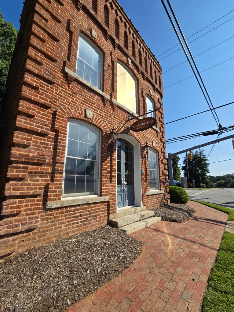
Summerfield was incorporated as a town in 1996 and has continued to grow and expand in all directions. The Brittain building, where people loved to gather around a pot-bellied stove to catch up on the local news, was donated to the town by Bill Parrish in 1996. It was restored and is used today as the Town Hall and a museum (4117 Oak Ridge Rd.).
Summerfield Farms
Located just 20 minutes north of downtown Greensboro, Summerfield Farms (3203 Pleasant Ridge Rd.) is a family-owned, working cattle farm and community gathering space. With weekly public community events, an on-site mobile bar, private venue rentals, produce and dry goods market, and luxury overnight lodging, Summerfield Farms offers a rural escape to relax and reconnect. All Summerfield Farms beef products, available for purchase online and in the Market, are 100% grass-fed, grass-finished, and AGA certified.
Oak Ridge
Until the late 1990s, the Oak Ridge area was mostly rural farmland with numerous tobacco farms. However, since its incorporation as a town in 1998, Oak Ridge has seen rapid growth in its population. Many of the area’s farms have been sold to developers and turned into upper-class housing developments, and several shopping centers have been built along the NC 68 corridor, especially at its intersection with Oak Ridge Road (NC 150), near the military academy. Each Easter weekend from 1945 to 2013, the community hosted a popular horse show.
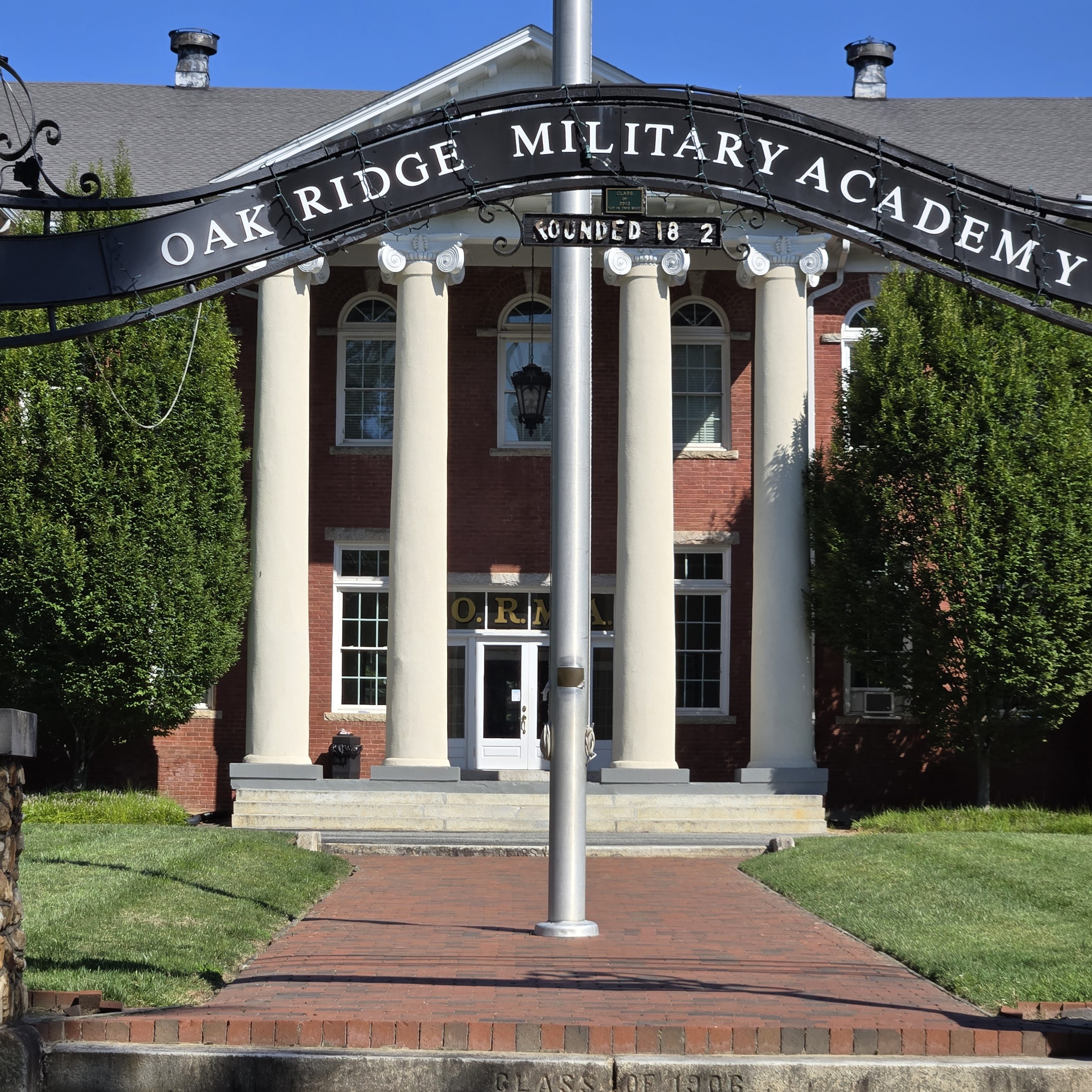
Oak Ridge Military Academy
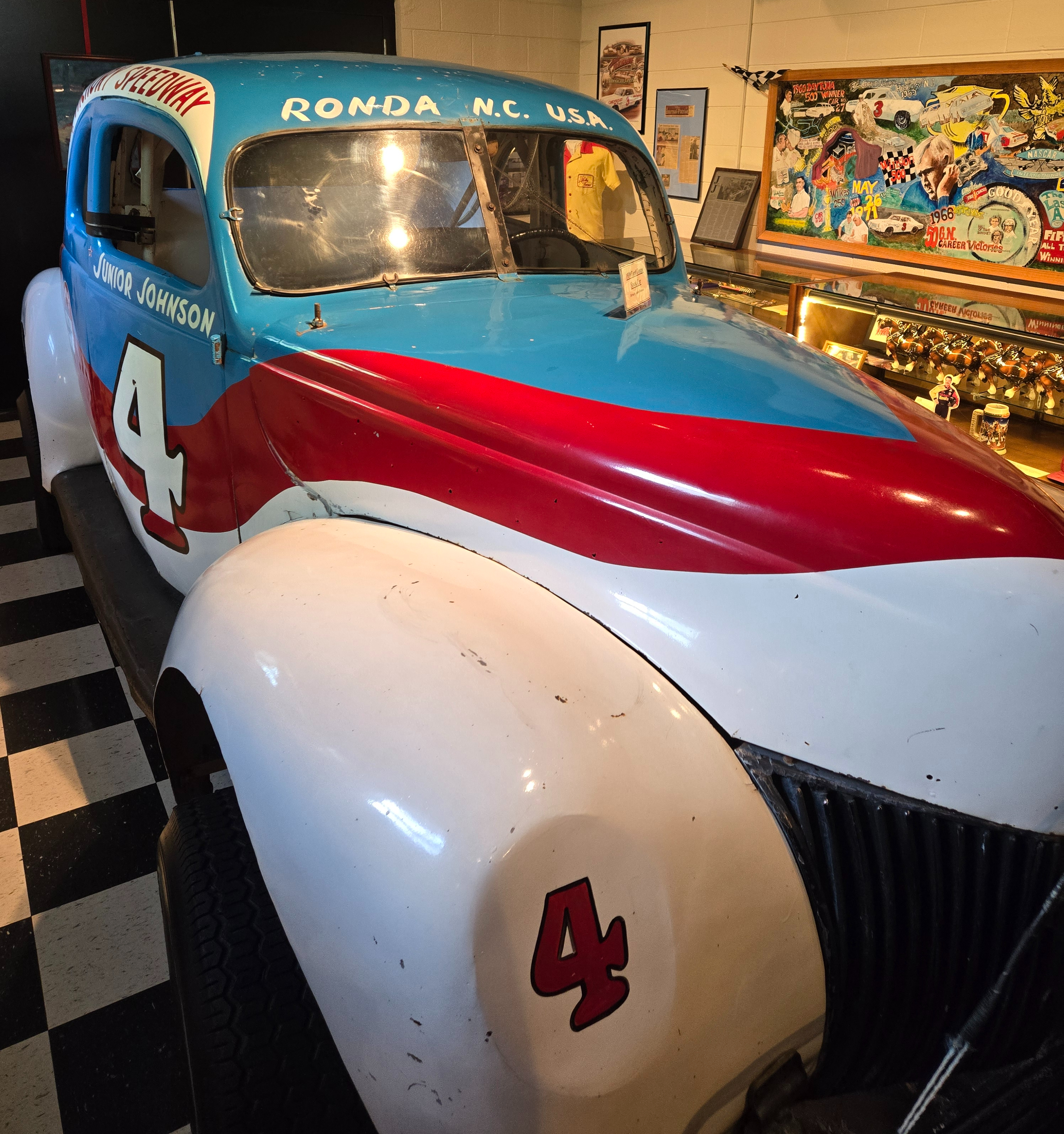
The town of Oak Ridge is home to Oak Ridge Military Academy, a private, co-educational, college-preparatory military boarding school. Founded in 1852, it is the third-oldest military school in the nation still in operation, and it is the official military school of North Carolina, as designated by the state legislature. Some famous students of the school include Dale Earnhardt Jr., NASCAR driver who attended the military academy prior to his racing career, and Kevin Harvick, also a NASCAR driver.
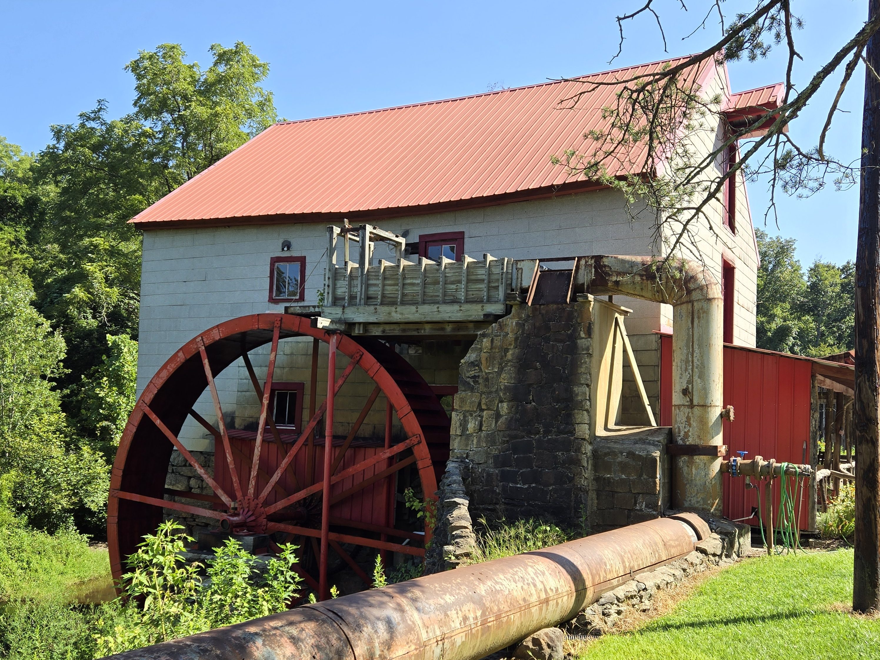
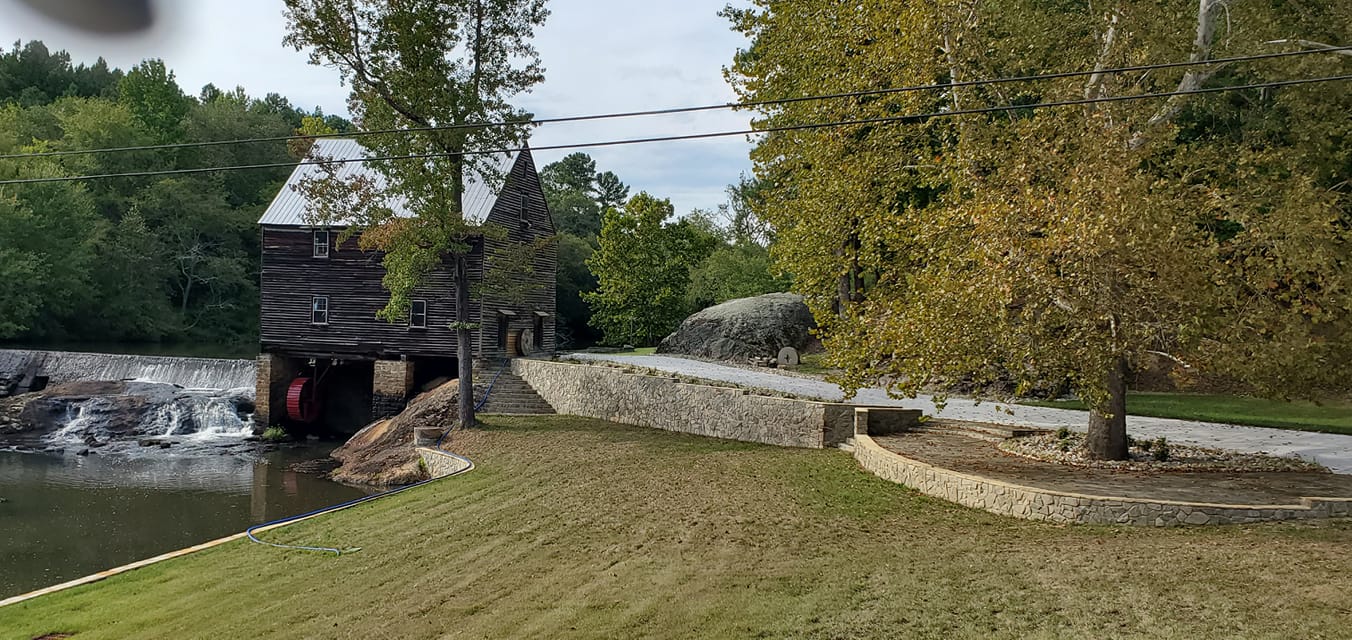
Old Mill of Guilford The Old Mill of Guilford is a favorite scenic stop for both locals and tourists. It is a fully operational, formerly water-powered, 18th century Grist Mill listed in the National Register of Historic Places. The Old Mill of Guilford was founded in North Carolina on Beaver Creek in 1767 to grind grain for the early settlers of what is now Guilford County. Today, the mill continues to produce all-natural, stone-ground, whole grain foods, just as it has for more than 240 years.
In 1767, before the colonists decided to seek independence from England, Daniel Dillon built a small tub mill in North Carolina on Beaver Creek, and went into business grinding grain for the early settlers. The Earl of Granville had granted Dillon the tract of 552 acres on Reedy Fork and Beaver Creeks in 1755.
On February 10, 1781, during the Revolutionary War, British troops under General Cornwallis marched past the mill in pursuit of General Greene who was encamped at Guilford Courthouse. Legend has it that British troops seized the mill to grind grain for the soldiers prior to the Battle of Guilford Courthouse on March 15, 1781.
The original tub mill and dwelling on 175 acres was sold to Joel Sanders for $900 in 1808. In 1819, Sanders moved the mill 500 feet down stream and built a new dam across the creek, which increased the millpond to 10 acres. The new mill was designed as a merchant corn and wheat mill with an overshot wheel to replace the small tub mill.
In 1913, the mill was purchased by K. L. Hendrix who later converted the mill to a roller mill and replaced the water wheel with a turbine. In 1932, state highway 68 was built between the dam and the mill. To keep the mill in operation, the long overhead wooden flume, which carried water from the dam to the mill, was replaced by a 26″ diameter steel pipe which ran under the new road. Clarence E. Bailes purchased the mill in 1954. Bailes removed the roller mill machinery and replaced the turbine with a 24’ x 4’ Fitz overshot water wheel, which still operates today.
A small addition was added to the side of the mill to serve as a sales office. Corn cleaners, bolters, and dust agriculture regulations were installed so that the mill could operate on a commercial basis. Lloyd Lucas became miller and operated the mill until his death in 1975, at which time the mill was closed. In 1976, C.E. Bailes sold the mill to James Flynt of Old Mill, Inc.
Old Mill Inc. was sold to Charles Parnell of Bailes Old Mill, LTD., in 1977. Mr Parnell renovated the mill, which had suffered from its two years of disuse and resumed its operation as a water-powered grist mill in keeping with its over 200-year tradition. Mr. Parnell married Heidi Brandt and together they ran the mill. With the help of volunteers, they developed a variety of new mixes and established a national reputation for quality products.
The water wheel was repaired in 2007, but the Parnells both died that year. Annie Laura Perdue became miller after many years of training under Charles Parnell. In 2008, Alice and Darrell Klug purchased the Old Mill of Guilford from Mrs. Parnell’s brothers, Hans and Alfred Brandt. Annie Laura Perdue remained the miller. Volunteers from the community assist in running the mill. The Klugs continue to introduce new products, maintain the historical integrity of the mill, and enhance the mill’s reputation for high-quality, natural stone-ground products.
Today, the Mill produces all natural corn meal, grits, and flour along with a wide range of mixes, including Gingerbread Mixes, Muffin Mixes, Pancake Mixes, Cookie Mixes, Scone Mixes, Biscuit Mixes, and Hushpuppy Mix. The Mill’s signature mix is the Sweet Potato Muffin. Visit the Old Mill Store for these products and other fine foods and crafts from North Carolina. You’ll also find products made by the Old Mill of Guilford throughout the area, and even at the coast.
The mill has also long been a favorite subject for artists and photographers alike. Please make plans to stop by and visit!
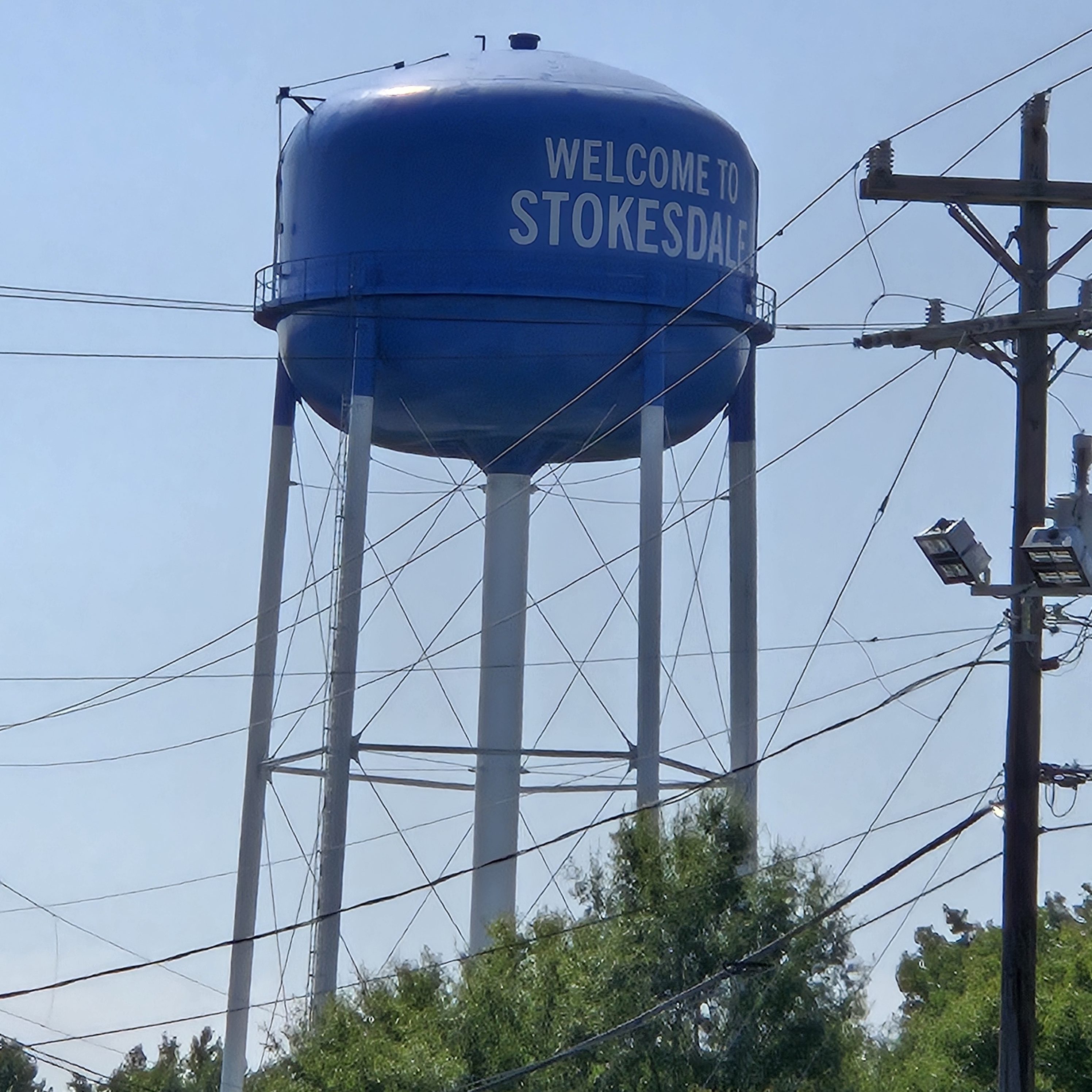
Stokesdale
Stokesdale, North Carolina, (incorporated in 1989) located in the northwest corner of Guilford County, is a rural community with a mixture of agricultural and farming areas, businesses, industries, and residential areas. The name Stokesdale was selected in honor of a Mr. Stokes who was either an executive of the railroad, a conductor on the train, or the surveyor who surveyed the area.
Back in the 1860s, before the era of automobiles and railroads, Stokesdale was called Green Pond. The name of Green Pond came into being because of a swampy pond located in the general area of what is now Ellisboro Road and Highway 65. In 1886, the Cape Fear and Yadkin Valley Railroad was built from Greensboro to Mount Airy.
Stonefield Cellars Stonefield Cellars (8220 NC-68) is a popular tasting spot for award-winning wines. The winery also hosts weddings, events, and live music nights as well. Guided tours are available, and you can also picnic in the gardens or relax on the patio with a glass of wine.
Browns Summit The community of Browns Summit remains rural, consisting of wooded areas and a mixture of open meadows and rolling farmland. Jesse Brown acquired the land in the area in 1858 and established a farm. In 1863, the Richmond and Danville Railroad built a line through the area and named it Browns Summit, as Brown’s farm rested at the highest point of elevation on the line.
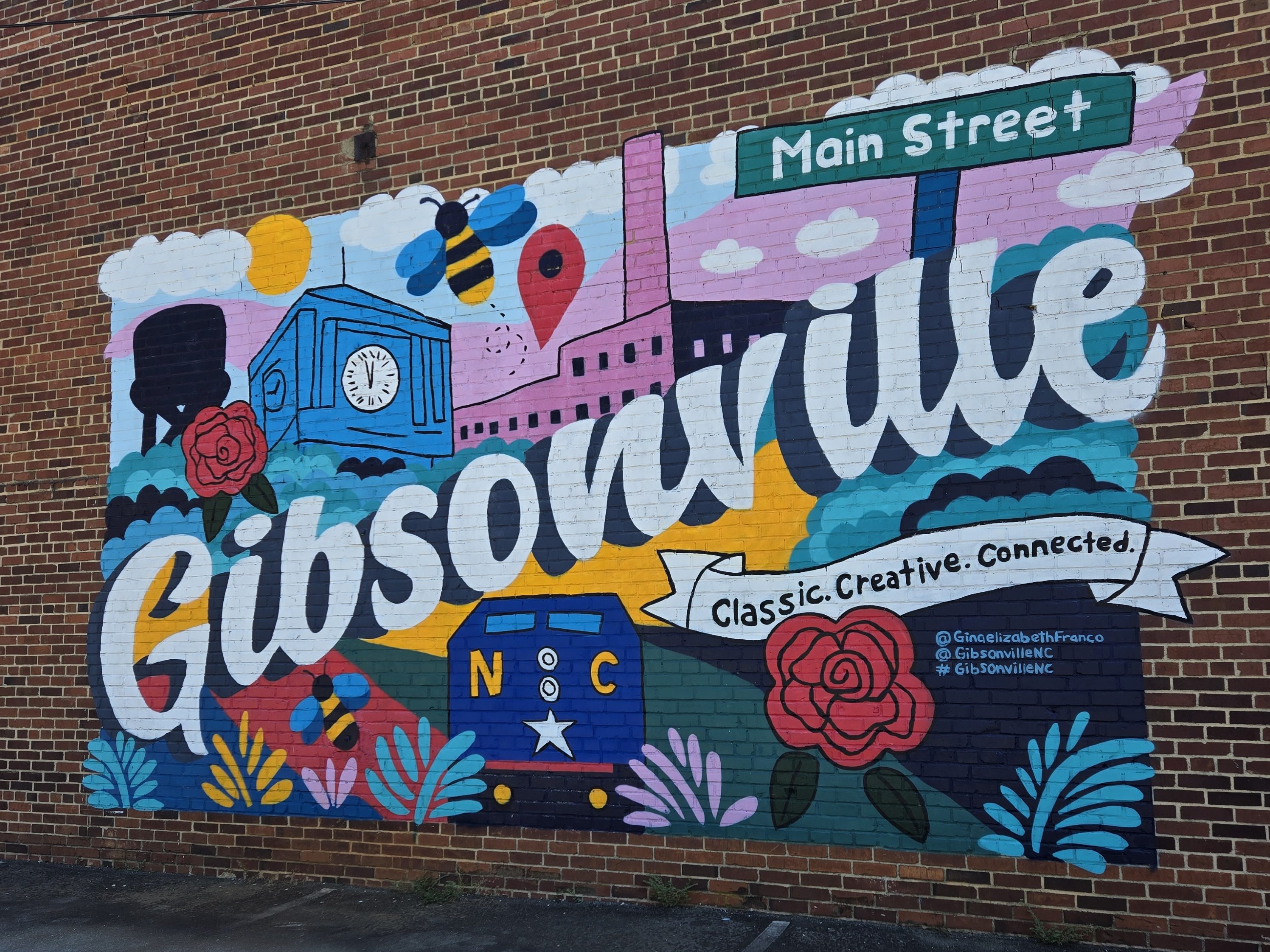
Gibsonville Gibsonville (“City of Roses”) is a town in both Alamance and Guilford counties. Most of Gibsonville is situated in Guilford County and the eastern portion is in Alamance County. Joseph Gibson (1785-1857), whose father established farming and gold mining operations in Gibsonville as early as 1775, was a local farmer who provided grading services in 1851 for the newly formed North Carolina Railroad (NCRR) Company. Shortly afterwards Gibsonville began to emerge as a commerce center.
The first train arrived on October 9, 1855, and the depot was named Gibson Station in his honor. On February 18, 1871, the state legislature issued a charter officially establishing the Town of Gibsonville.
Gold mining played a minor role here when deposits were discovered on Gibson Hill (or Gold Hill) south of town in the early 1800s. In 1888, the Chifar Consolidated Gold Mine Company began crushing ore at a mine a half mile south of the depot in Gibsonville.
The Depot Greens served as a holding area for livestock and agricultural goods being shipped out on the railroad, which was the primary economic purpose of Gibsonville. In 1886, a local self-taught entrepreneurial mill builder, Berry Davidson, constructed the steam powered Minneola textile mill on Railroad Avenue. Subsequently, he built the Hiawatha textile mill on Eugene Street in 1893. Together, these mills transformed Gibsonville from an agricultural shipping station into a vibrant small town with an industrial base. When the mills closed in the 1980s, the town slowly transformed itself into a commuter residential community for the Burlington and Greensboro metro areas. Gibsonville has been known as the “City of Roses” since at least 1920, when train passengers could see the large number of rose bushes along the railroad tracks at the Minneola Mill.
Gibsonville Garden Railway The Gibsonville Garden Railway (200 E Main St.) is an outdoor train display running more than 2900 feet of G-scale train track with 22 trains running at one time. The Gibsonville Garden Railroad (GGRR) was founded in 1996 by Bobby Summers, a retired Freight Conductor on the Southern Railroad. The first trains ran on October 9, 1996, which coincides with the first train arriving at Gibson Station on October 9, 1855. The village buildings are arranged to represent Gibsonville in 1855 and 1922, so the Town Historic Walking Tour map can be used to understand the layout. The village covers all of North Carolina from Blowing Rock and Pilot Mountain to the Cape Hatteras Lighthouse. You’ll also find dioramas for Elon Homes, Elon College, Company Shops (Burlington), a gold mine, and tar making. You can see both Orville and Wilbur Wright flying and cable cars too, plus ride on the playground train. The trains and village are managed, maintained, and monitored by volunteers. The display is open every Saturday from April through November from 9:00 a.m. to noon, but you can stop and view the village any time.
Gibsonville Antiques & Collectibles
If you’re a history buff, antique lover, or collector of any sort, you’ll want to stop at Gibsonville Antiques & Collectibles (106 E. Railroad Ave.). The store features over 18,000 square feet of vintage items from assorted local vendors as well as furniture restoration services.
Whitsett The Town of Whitsett is located in eastern Guilford County. The Town of Whitsett was incorporated July 13, 1991.
Red Oak Lager Haus & Biergarten
Boasted as America’s largest lager-only brewery, Red Oak Lager Haus & Biergarten (6905 Konica Dr.) is a must-stop place not only for the brew but also for the indoor bar area and outdoor seating among many sculpture and art pieces, music, and more. Red Oak Brewery, North Carolina’s oldest brewery, has been crafting beer since 1990. They brew unfiltered, unpasteurized lagers, staying true to the roots with pure and simple beer. They follow the 1516 Bavarian Purity Law, using only the finest water, malted barley, hops, and yeast. The facility also hosts periodic food trucks and events — and you can schedule your own event here as well. Call ahead to book a tour, if you like. They also recently added the Griffith Fine Art Museum!
Sedalia Incorporated in August 1997, the Town of Sedalia lies between the urban centers of Burlington and Greensboro. Mr. R. B. Andrews owned and operated a little country store and in the back of that store was the post office. People would gather in the store to pick up mail and gather for news. Mr. Andrews, the Postmaster, chose the name “Sedalia” for the community.
In 1901, an 18 year-old woman named Charlotte Hawkins came to the community. She came to teach rural African-American youth at Bethany Institute in Sedalia, now known as Bethany Community Church. In 1902, after vigorously raising money in New England, Charlotte Hawkins founded the Palmer Memorial Institute, a day and boarding school. She established the school in a converted blacksmith’s shop and named it in honor of Alice Freeman Palmer, her mentor and benefactor. In 1911, she married Edward S. Brown, a student at Harvard.
In its early years, Palmer’s curriculum emphasized agricultural and industrial education for rural living. Brown expanded the school to more than 350 acres, including a sizable farm. As years passed, the school’s academic importance and its emphasis on cultural education increased. During her 50-year presidency, more than one thousand students graduated. They gained not only diplomas but also firm ideas of their own worth. Dr. Brown served Palmer Memorial for all those years, and 10 years after her death in 1961, the school closed.
In 1983, the General Assembly appropriated funds to institute plans to renovate and restore Palmer to its original state. The Charlotte Hawkins Brown Museum at former Historic Palmer Memorial Institute is located in the heart of Sedalia on Burlington Road (Highway 70).
Charlotte Hawkins Brown Museum & State Historic Site The Charlotte Hawkins Brown Museum & State Historic Site (6136 Burlington Rd) is a North Carolina State Historic Site. As the historic campus of Palmer Memorial Institute (founded in 1902), it is also North Carolina’s first historic site dedicated to African American history. Start at the welcome center, then tour the grounds, which include 13 other stops: Kimball Hall, a dormitory, a tea house, the Teacher’s Cottage, and the Charlotte Hawkins Brown gravesite and memorial. Admission is free, and donations are accepted.
Jamestown As early as 1701, the Keyauwee people were living in a village in the Jamestown region. By the late 18th century, European settlers came to Jamestown. Many were Quaker families who moved to the area from Pennsylvania in search of productive farmland. Among the original settlers was James Mendenhall, who established a farmstead near present-day Jamestown in 1752. Though Mendenhall moved to Georgia in 1775, his son George remained and, by 1816, he founded the village of Jamestown in honor of his father.
The Mendenhall family, who owned and operated the area’s first grist and lumber mills, also owned much of the town’s original land. Today, High Point City Lake is situated where the original family farmhouse and land was located. In 1781, during the Revolutionary War, British General Cornwallis’ army camped near the settlement and commandeered provisions from local farms and mills prior to his engagement with Nathanael Greene’s troops at New Garden, in modern-day Greensboro.
By 1800, Jamestown was a bustling settlement of 150 residents with its own post office, inn, and Freemasons’ lodge. Around this same time, gold was discovered near Jamestown, and several mines profited until the California Gold Rush frenzy shut down local efforts. In 1811, James Mendenhall’s son Richard, a local tanner, built the Mendenhall Plantation homestead, a highlight of any tour of Jamestown today.
In addition to farming and related industries, Jamestown was home to a gun factory, which manufactured a sturdy and accurate muzzle-loading gun known as the “Jamestown Rifle”, the mainstay of Jamestown’s industry through the latter half of the 19th century and a highly prized collectible among gun enthusiasts today.
During the Civil War, Jamestown’s Quakers, who opposed war and violence, attempted to remain neutral. However, the Confederacy demanded that those who were able to make shoes, uniforms, or weapons continue to do so or pay heavy taxes. Records indicate that Confederate President Jefferson Davis and his entourage passed through Jamestown during their hasty retreat to the south after the Civil War ended.
Prior to the war, Jamestown was a known “stop” along the Underground Railroad, which helped fugitive slaves reach freedom in the North. According to local historical records, many Quaker homes in this area had a trap door leading to the basement to help slaves escape. Further, according to records, the Mendenhall and Beard families were instrumental in assisting in emancipation efforts.
DowntownJamestown
Downtown Jamestown is a vibrant, evolving, and eclectic area that has transformed from a regional retail hub to a mixed-use center. It features a mix of residential, commercial, and cultural spaces, including small retail enterprises, restaurants, and cultural attractions. The area is known for its cultural and entertainment anchors, contributing to its reemergence as a small, bustling downtown.
Photographed above is the famous — or infamous — Lydia’s Bridge. It is said that the ghost of the forlorn young Lydia haunts this bridge at night. When there used to be a round passing under this bridge, occasional drivers would claim to see her ghost. The road was eventually moved alongside of the bridge and the area became overgrown with brush. But that didn’t stop people from jumping the fence to explore. Today, the bridge has been restored and there is a walking path to the bridge coming from both directions. No word if Lydia is still seen in this area…
City Lake Park
High Point City Lake Park (602 West Main St., Jamestown) offers many family-friendly activities: a merry-go-round ride, train ride, 20-passenger excursion boat ride, kayak, canoe, paddle boards, and more. You’ll also find a marina, fishing pier, aquatic center, playground, and miniature golf course, plus a meeting and event center, picnic shelters, tables, grills and concession stands.
Mendenhall Homeplace Directly across from City Lake Park, you’ll find Mendenhall Homeplace (603 West Main St.). The Richard Mendenhall farmhouse was built in 1811, and consists of a two-story, brick main block of plain typically Quaker design, with a porch on three sides and a number of additions to the west and rear. Also on the property is a large early Red Bank Barn of the Pennsylvania German type, Underground Railroad False Bottom Wagon, One Room School House, Dr. Madison Lindsay’s House, Museum, Thy Store, and a Well House. Check for varied open hours and tour times at different times of year.
Castle McCulloch The Castle McCulloch Gold Mill (3925 Kivett Dr.) is a restored gold refinery in Jamestown listed on theNational Register of Historic Places. Built by Charles McCulloch, a Cornish engineer who brought the new steam engine technology to North Carolina from England, the structure was completed in 1823 and restored in the early 1980s. It is a granite castle, complete with drawbridge, moat, and 70-foot tower. Using locally quarried granite, McCulloch and stonemason Elizier Kersey created a Cornish Rock Engine House for the refining of gold ore, with a “Walking Beam” steam engine that powered Chilean mill ore crushers.
After years of ownership within the McCulloch family, the site passed through several hands and fell into disrepair before being bought and rebuilt by Richard Harris during the mid-1980s. It is maintained by the McCulloch Foundation. The site is popular for such occasions as weddings, receptions, and corporate events. In 1997, the Crystal Garden was built nearby, with Victorian-style beveled glass walls, a crystal chandelier, and a veranda with a view across a lake to the castle. The gold mill-which operated on the grounds of the castle for its first three decades once offered gem and gold panning, historical tours, and rock quarry visits. The castle may currently be in foreclosure, so its future operations are questionable at this moment.
Kersey Valley Attractions
If you’re looking for a day of grown-up and kid fun and entertainment, Kersey Valley Attractions (1615 Kersey Valley Rd.) is the place to be. In operation since 1986, the facility has grown from its original makeshift haunted attraction to the now-famous, acres-large Spookywoods, one of the country’s top haunted attractions year after year. Beyond Halloween, KV also hosts year-round experiential entertainment, including indoor and outdoor axe throwing, zip lining, laser tag, high-tech escape rooms, bomb bowling, and more. KV also hosts other family-friendly seasonal attractions: Maize Adventure and Kersey Valley Christmas. (Having known the owners for about 30 years, I can attest that no expense is spared for the guest experience and guest safety.) Kersey Valley Attractions and the Castle McCulloch are just a few minutes from one another.
Furnitureland South & The World’s Largest Chest of Drawers Furnitureland South (5635 Riverdale Dr.) is the biggest furniture store in the USA and potentially the world with 1.3 million square feet of showroom space filled with furniture and decor of all styles. Since 1969, Furnitureland South has been a one-stop-shop for all things home décor, including the Mart, the Showroom, and the Outlet. The property also contains an 85-foot-tall highboy — the world’s largest chest of drawers!
High Point High Point is North Carolina’s only city that extends into four counties. Major industries in High Point include furniture, textiles, and bus manufacturing. The city’s official slogan is “North Carolina’s International City” or “The Furniture Capital” due to the semi-annual High Point Furniture Market that attracts up to 100,000+ exhibitors and buyers from around the world (in April and September). It is also home to High Point University, a private and affluent Methodist-affiliated institution founded in 1924.
High Point was at the highest point of the 1856 North Carolina Railroad between Charlotte and Goldsboro, where it intersected the 1852 Great Western Plank Road. Its central location and transportation allowed for the delivery of raw materials like cotton and lumber as well as import and export of processed goods, contributing to its early growth. High Point was settled by Europeans, including English Quakers and German immigrants, before 1750, but was not incorporated until 1859. Before it became a major manufacturing center, the most important industries were tobacco, woodworking, and textiles.
The High Point Market is the largest home furnishings industry trade show in the world, with more than 11 million square feet and about 2,000 exhibitors throughout about 180 buildings. The market holds two major shows each year, and attracts between 70,000 and 100,000 attendees. A 2018 Duke University study showed that the market contributes approximately $6.7 billion to the area’s economy. Many of the buildings and showrooms are only used a few weeks each year, during the two international furniture and accessories markets.
Notable people from the High Point area include…
Fantasia Barrino, Grammy Award-winning singer and season 3 winner of American Idol
Dave Blaney, NASCAR driver
Ryan Blaney, NASCAR driver
John Coltrane, jazz saxophonist, was born in Hamlet and moved to High Point shortly after birth, remained through high school
Bill Davis, owner of Bill Davis Racing of NASCAR
Perley A. Thomas, founder of Thomas Built Buses
Maxwell Thurman, U.S. Army general who helped develop the longtime “Be All You Can Be” Army recruitment campaign
DowntownHigh Point
A walk through the downtown area of High Point is a who’s who tour among furniture manufacturers. You’ll find a variety of architecturally impressive furniture showroom buildings, including the boat building and Showplace as well as the massive, blocks-long and stories-tall International Home Furnishings Center (IHFC). Note that the general public is not allowed entry to these buildings at any time of year, and most of these buildings are largely unused for most of the year. The semi-annual Furniture Market (and premarket) occurs every April and September, attracting furniture buyers from more than 90 countries. At these times of year, you’ll find the city super bustling, with tons of activity as well as indoor and outdoor ticket-only events for market attendees.
High Point Museum and Historical Park The High Point Museum (1859 East Lexington Ave.) is the perfect place to explore High Point’s history, including 37,000+ artifacts and four historic buildings on the property. Of note, you’ll find jazz musician John Coltrane’s piano, a Thomas Built school bus, a blacksmith shop, little red school house, and documentation of the area’s history in the furniture industry. Admission is free to tour the museums and the historical park.
Piedmont Environmental Center
The Piedmont Environmental Center (1220 Penny Rd.) boasts 11 miles of trails on a 376-acre nature preserve. Nature-based classes and programs are available for both children and adults. Pictured above is an interactive topographical map of North Carolina.
Museum of Old Domestic Life Immerse yourself in this 19th-century historic Quaker meeting house built in 1858. At the Museum of Old Domestic Life (555 East Springfield Rd.), you will find that this hidden gem of High Point is filled with detailed depictions of cloth making, shoe cobbling, cooking, farming and more. Learn about the everyday necessities utilized by the Quaker community during this rural time period. One of the things which makes the museum special is that it’s a“hands on” place, as you can touch and handle most of the items on display. Visitation is by appointment only. Because the Museum has no HVAC system, the best time to visit is in the spring, summer or fall; there is no heat in the building, so wrap up warmly if you visit during December-February.
High Point Rockers Stadium
The High Point Rockers has been in operation since its inaugural game in May of 2019. The Rockers are an American professional minor-league baseball team based at Truist Point ballpark (301 North Elm St.). The team was formed when the Bridgeport (Connecticut) Bluefish moved its team to High Point after their home stadium of 20 years closed in 2017 to become a music amphitheater. Ground was officially broken in High Point on April 11, 2018. When at the stadium, be sure to stop by the neighboring Stock & Grain food hall for a variety of local food purveyors (no chain restaurants). P.S. The brisket is melt-in-your-mouth a-mazing!
High Point University (HPU)
High Point University (One University Parkway) is considered by many to be a taj mahal of university campuses. The University has a wide and ever-expanding footprint in High Point, even purchasing the nearby Oak Hollow Mall. Visitors can explore the campus, attend cultural events, and even take guided tours. The public can visit the gardens, take a campus walking tour, or attend various cultural events, including musical performances, art displays, and guest speakers.
Nido & Mariana Qubein Children’s Museum The Nido & Mariana Qubein Children’s Museum (200 Qubein Avenue) is one of the children’s museums this blogger has seen. Nido Qubein is the president of High Point University, and he has made a huge impact in this area, expanding well beyond the University’s enormous footprint. The children’s museum provides two floors (75,000 square feet) of entertainment and experiential, interactive, hands-on fun and learning for kids.
High Point Train Depot Built in 1907 and once the pivotal location for arriving families and WWII soldiers, High Points historic train depot (100 West High Ave.) is one of the city’s best-known landmarks. With a complete restoration in 2003, this modern Amtrak stations maintains every bit of its original architectural charm. Trains pass through regularly throughout the day.
John Coltrane Statue The John Coltrane Statue is an 8-foot tall bronze tribute to one of High Point’s most acclaimed citizens, alumnus of William Penn High School, and legendary jazz saxophonist John Coltrane. The statue can be found at the corner of Commerce Avenue and Hamilton Street, in downtown High Point next to High Point Theatre. Coltrane is best known for his work with famed trumpeter Miles Davis and pianist Thelonious Monk.
All-a-Flutter Farms All-A-Flutter Farms is an agritourism farm and plant nursery (7850 Clinard Farms Rd.) promoting the education, conservation, and habitat restoration of the monarch butterfly. The farm is mainly a field trip facility for large school groups but they also hold family and smaller group days as well. Both adults and kids will enjoy the interactive demonstration, then have time in the Flight House surrounded by hundreds of monarchs. All-A-Flutter Farms is the only facility that encourages hand feeding of the butterflies to provide an up-close experience. You are also welcome to utilize the picnic and playground areas, walk the nature trail, feed the farm’s goats, and browse their selection of perennial plants cultivated in the farm’s nursery. Each plant variety grown on the farm has a purpose for pollinators, providing not only aesthetic beauty, but a sustainable host and/or nectar source for generations of pollinators in your own back yard. At certain times of year, you can purchase a monarch chrysalis to take home with you, watch the monarch butterfly emerge, and release it into the wild.
Colfax Colfax is a small unincorporated community and is a suburb of Greensboro and High Point. Its main attraction is the Robert G. Shaw Piedmont Triad Farmers Market (2914 Sandy Ridge Rd.), where people shop for fresh food from local farmers. It is also the location of one of 15 Piano and Organ Distributors, one of the largest piano sellers in the country.
In 2000, the community attempted to incorporate, but failed after a joint commission found that the proposed limits were not sufficient for incorporation under North Carolina law, lacking under the population density requirement. On June 30, 2008, the city of Greensboro annexed the main part of Colfax into the city limits and in 2010, the City of High Point annexed Southern portions of the area, though some of Colfax is still unincorporated.
Colfax was home to the Colfax Persimmon Festival, which held its 14th and final annual event in October 2021. The gathering was held on a historic farm on N. Bunker Hill Road, north of the main road through town.
Triad Park
Triad Park (9652 West Market St.), which splits the border between Guilford County and Forsyth County, is a popular destination for outdoor activities and gatherings. You’ll find many miles of walking trails surrounded by native plantings in this 6,000-acre park. Triad Park is also home to the Carolina Field of Honor, a veterans memorial park honoring all branches of the military, including a water fountain surrounding a large obelisk sculpture.
Raleigh is the second-largest city in North Carolina by population, fifth-largest by size, the 10th-most populous city in the Southeast, the 41st-most populous city in the U.S., and the largest city of the Research Triangle metro area. Raleigh is known as the “City of Oaks” for its many oak trees, which line the streets in the heart of the city. The city of Raleigh is named after Sir Walter Raleigh, who established the now-lost Roanoke Colony in present-day Dare County.
Raleigh is home to North Carolina State University (NC State or NCSU) and is part of the Research Triangle together with Durham (home of Duke University and North Carolina Central University) and Chapel Hill (home of the University of North Carolina at Chapel Hill). The name of the Research Triangle (often shortened to “The Triangle”) originated after the 1959 creation of Research Triangle Park (RTP), located in Durham and Wake counties, among the three cities and universities, encompassing the Raleigh-Durham-Cary, NC Combined Statistical Area.
Most of Raleigh is located within Wake County, with a small portion extending into Durham County. The towns of Apex, Cary, Clayton, Fuquay-Varina, Garner, Holly Springs, Knightdale, Morrisville, Rolesville, Wake Forest, Wendell, and Zebulon are some of Raleigh’s primary nearby suburbs and satellite towns.
Raleigh is an early example in the United States of a planned city. Following the American Revolutionary War when the U.S. gained independence, the area was chosen as the site of the state capital in 1788 and incorporated in 1792. The city was originally laid out in a grid pattern with the North Carolina State Capitol at the center, in Union Square. During the American Civil War, the city was spared from any significant battle. It fell to the Union in the closing days of the war and struggled with the economic hardships in the postwar period, related to the reconstitution of labor markets, over-reliance on agriculture, and the social unrest of the Reconstruction Era. The establishment of the Research Triangle Park (RTP) in 1959 helped create tens of thousands of jobs in the fields of science and technology. By the early 21st century, Raleigh had become one of the fastest-growing cities in the United States.
On January 5, 1771, the bill creating Wake County was passed in the General Assembly. The county was formed from portions of Cumberland, Orange, and Johnston counties, and was named for Margaret Wake Tryon, the wife of Governor William Tryon.
The first county seat was Bloomsbury. New Bern, a port town on the Neuse River 35 miles from the Atlantic Ocean, was the largest city and the capital of North Carolina during the American Revolution. When the British Army laid siege to the city, that site could no longer be used as the capital. From 1789 to 1794, when Raleigh was being built, Fayetteville served as the state capital.
Raleigh was chosen as the site of the new capital in 1788, as its central location protected it from attacks from the coast. It was officially established in 1792 as both county seat and state capital. The city was incorporated on December 31, 1792, and a charter granted January 21, 1795.
In 1831, a fire destroyed the North Carolina State House. Two years later, reconstruction began with quarried gneiss being delivered by the first railroad in the state. Raleigh celebrated the completion of the new State Capitol and new Raleigh & Gaston Railroad Company in 1840. In 1853, the first State Fair was held near Raleigh. And Raleigh’s Historic Oakwood contains many houses from the 19th century that are still in good condition.
In 1880, the newspapers News and Observer combined to form The News & Observer. It continues today to be Raleigh’s primary daily newspaper. The North Carolina College of Agriculture and Mechanic Arts, now known as North Carolina State University, was founded as a land-grant college in 1887.
In 1912, Bloomsbury Park opened, featuring a popular carousel ride. Relocated to Pullen Park, the Pullen Park Carousel is still operating.
From 1914 to 1917, an influenza epidemic killed 288 people in Raleigh.
In 1922, WLAC signed on as the city’s first radio station, but lasted only two years. WFBQ signed on in 1924 and became WPTF in 1927. It is now Raleigh’s oldest continuous radio broadcaster.
During the difficult 1930s of the Great Depression, government at all levels was integral to creating jobs. The city provided recreational and educational programs, and hired people for public works projects. In 1932, Raleigh Memorial Auditorium was dedicated. The North Carolina Symphony, founded the same year, performed in its new home. In 1939, the State General Assembly chartered the Raleigh-Durham Aeronautical Authority to build a larger airport between Raleigh and Durham, with the first flight occurring in 1943.
Raleigh experienced significant damage from Hurricane Hazel in 1954.
With the opening of the Research Triangle Park in 1959, Raleigh began to experience a population increase, resulting in a total city population of 100,000 by 1960. In 1960, the Census Bureau reported Raleigh’s population as 76.4% White and 23.4% Black.
Following the passage of the federal Voting Rights Act of 1965, one of the main achievements of the Civil Rights Movement and the Lyndon B. Johnson presidency, political participation and voting by African Americans in Raleigh increased rapidly.
During the 1988 Raleigh tornado outbreak of November 28, 1988, the city was affected by the most destructive of the seven tornadoes reported in Northeastern North Carolina and southeastern Virginia between 1:00 am and 5:45 am. The Raleigh EF-4 tornado produced over $77 million in damage, along with four fatalities (two in the city of Raleigh, and two in Nash County) and 154 injuries. The damage path from the storm was measured at 84 miles long, and one-half mile wide at times.
In 1996, the Olympic Flame passed through Raleigh while on its way to the 1996 Summer Olympics in Atlanta. Also in 1996, Hurricane Fran struck the area, causing massive flooding and extensive structural damage.
In 1997, the National Hockey League’s Hartford (CT) Whalers announced their intention to move to Raleigh as the Carolina Hurricanes, becoming the city’s first major league professional sports franchise. They went onto win the Stanley Cup in 2006, North Carolina’s first professional sports championship.
In April 2011, a devastating EF-3 tornado hit Raleigh, and many other tornadoes touched down in the state (ultimately the largest, but not the strongest outbreak to ever hit the state), killing 24 people. The tornado tracked northeast through parts of downtown, East Central Raleigh and Northeast Raleigh and produced $115 million in damages in Wake County. There were 4 fatalities in the city.
Mordecai House/Historic Park
Mordecai Historic Park (1 Mimosa St.) is part of Raleigh’s Park system with its most prominent feature being the Mordecai family’s 1785 home. Other buildings on the property include the smokehouse and plantation office. Additional buildings were relocated to the property in the 1970s. The park grounds are open to the public sunup to sundown 365 days a year. The Visitor’s Center has separate hours of operation, and guided tours of the property and historic buildings can be arranged in advance on select days.
BONUS: You can take the Historic Raleigh Trolley right from the Mordecai House and take a tour of downtown Raleigh, including hot spots, historical and architectural stops plus fun facts and fascinating stories, on Saturdays from March through December.
Freedom Park
Freedom Park (218 N. Wilmington St.) is a tribute to the spirit of the African-American struggle for freedom and the universal ideals of liberty, resilience, and equality. Open daily from dawn to dusk, the park has a central public art sculpture surrounded by a variety of famous quotes about strength and the human condition along with several observational benches.
NC Museum of Natural Science
The North Carolina Museum of Natural Science (11 W. Jones St.) has something for everyone: dueling dinosaurs, an arthropod zoo, science atrium, natural exhibits, coastal exhibits, fossils, space exhibits, astronomy and astrophysics, weather, live animal exhibits, and more. Peruse through 4 floors, the first three of which have 2 wings expanding across the plaza to a second building. Grab a bite at one of the two cafes, shop in the gift store, attend live demonstrations, and join the museum family.
NC Museum of History
Across the plaza, is the North Carolina Museum of History (5 E. Edenton St.), which is currently closed for renovation. No projected reopening date has been given.
NC State Capitol
A trip to Raleigh isn’t complete without a self-guided tour through the NC State Capitol building ( 1 E. Edenton St.). A national historical landmark and a premium example of Greek Revival architecture, the building features a domed rotunda, meticulously restored, 1840-era legislative chambers, and historic museum space that include a State Geologist’s Office and State Library. It is still a working capitol building today, as the governor’s offices are still located here. Peruse through 3 levels of chambers, statuary (inside and outside), and artwork — complete with the original and very worn marble interior steps. Admission is free during open hours for self-guided tours and guided tours for groups of 10 or more can be arranged in advance.
City of Raleigh Museum
The City of Raleigh (COR) Museum (220 Fayetteville St.) is a beautifully restored architectural gem in downtown Raleigh and part of the Raleigh Parks system. Housed in the historic Briggs Hardware building, the museum features both temporary and permanent exhibits that pay homage to Raleigh’s past and look to the City’s future as well. The museum maintains a collection of more than 10,000 objects. Admission is free, though donations are accepted and memberships are welcomed.
Pope Museum House
The Pope Museum House (211 S. Wilmington St.) is Raleigh’s only African American House Museum.
Joel Lane Museum House
Built in 1769, the Joel Lane Museum House (728 W. Hargett St.) is the oldest house in Wake County. The colonial Georgian house furnished with plantation life artifacts is the birth home of Joel Lane, who is also called the father of Raleigh because he sold 1,000 acres of his own land in 1792 to the state of North Carolina to establish the state’s new capital city. Guided tours are available.
Pullen Park
Part of the Raleigh Parks system, Pullen Park (520 Ashe Ave.) was North Carolina’s first public park and is recognized as the 14th oldest amusement park in the world. The park includes a 1911 Gustav A. Dentzel managerie carousel, C.P. Huntington train ride, boat rentals, ball fields, playgrounds and picnic facilities, concessions, and more. You’ll also find a TV Land Andy & Opie statue. The park is open 7 days a week.
Note: On busy days, it can be challenging to find a parking spot.
Gregg Museum of Art & Design
Visit the Gregg Museum of Art & Design (1903 Hillsborough St.) to see a variety of rotating art exhibits
BONUS: You’ll find one of Vollis Simpson’s whirligigs called “Crossroads” displayed as a permanent exhibit on the museum grounds. And you’ll see another one in Raleigh at the NC Museum of Art/Ann and Jim Goodnight Museum Park. See our Wilson County blog for the incredible Vollis Simpson Whirligig Park in Wilson, NC, which displays a full city block of his famous and NC-treasured whirligigs.
CAM Raleigh
Visit Contemporary Art Museum (CAM) Raleigh to view a variety of rotating exhibits featuring local and national artists.
From their website: CAM Raleigh is the non-collecting contemporary art museum that provides an environment for transformation through educational programs, cultural experiences, and bold, non-traditional exhibitions by living artists. CAM Raleigh is located on and near unceded land settled over the last 14,000 years by indigenous people. CAM is located on land that was used for family life, nourishment, stewardship, trade, justice, ceremony, and healing. CAM acknowledges the history of oppression and injustice that marginalized indigenous people and is a part of the history of the land we now inhabit. Indigenous people exist today by their contemporary tribal names of the Cherokee, Coharie, Haliwa-Saponi, Lumbee, Meherrin, Tuscarora, Occaneechi, Sappony, and Waccamaw-Siouan. CAM continues to look for ways to honor the people who came before us and to learn from our history.
JC Raulston Arboretum
A visit to the JC Raulston Arboretum (4415 Beryl Rd.) brings you among one of the most comprehensive plant collections in the Southeast with more than 8,000 plant varietals, including a nationally accredited redbud collection. As part of the Dept. of Horticultural Science at North Carolina State University, you can explore 10.5 acres with more than 17 designated gardens and viewing areas filled with plants collected from around the world. Of note is the lovely Air Bee & Bee hive sculpture, housing a variety of residences for different bees. Admission is free, and donations are accepted. There’s a lovely little gift shop on the property — and you can become a member as well.
NC Museum of Art/Ann and Jim Goodnight Museum Park
This walkable park is one of the largest art-focused parks in the country. You’ll find many public art and sculpture displays, including earth casting by Raleigh artist Thomas Sayre. You can also find Sayre’s work in both Greensboro and Kinston.
BONUS: You’ll see one of Vollis Simpson’s whirligigs here at the NC Museum of Art/Ann and Jim Goodnight Museum Park. And you’ll find another one called “Crossroads” displayed as a permanent exhibit on the Gregg Museum of Art & Design grounds. See our Wilson County blog for the incredible Vollis Simpson Whirligig Park in Wilson, NC, which displays a full city block of his famous and NC-treasured whirligigs.
Historic Yates Mill Country Park At 174 acres, this wildlife refuge and environmental research center has it all—3 miles of hiking trails, a 24-acre pond and Historic Yates Mill, Wake County’s last remaining 18th-century, water-powered grist mill (fully restored and operable!). Visit the research center and tour the mill to learn about the “farm-to-fork” process, witness the corn grinding process and purchase bags of ground yellow and white cornmeal. Admission is free, but the mill tour (available to the public March through November) is $3-$5. Park maps are available as well as brochures for common birds found in the area as well as trees found throughout the park.
William B. Umstead State Park
From 1934 to 1937, the federal Civilian Conservation Corps (CCC) constructed the area now known as William B. Umstead State Park (8801 Glenwood Ave., Raleigh). Located in Wake County between Raleigh and Durham boasts man-made lakes; fishing; 13 miles of multiuse trails; and tent, trailer, and primitive camping; and the highly popular artistic tree carving that’s a must see — right on the Graylyn trail. Stop by the Visitor Center for printed directions to find the tree.
Wake County was formed in 1770 from parts of Cumberland, Johnston, and Orange Counties. And prior to English colonization, present-day Wake County was part of the Tuscarora nation. However, Wake County did lose some of its territory through the formation of other counties, including Franklin County in 1787 and in Durham County in both 1881 and 1911. The first courthouse was built at a village originally called Wake Courthouse, now known as Bloomsbury. In 1771, the first elections and court were held, and the first militia units were organized.
During the colonial period of North Carolina, the state capital was originally located in New Bern. For several years during and after the Revolutionary War, there was no state capital, and the General Assembly met in various locations. Fayetteville served as the state capital in 1786, 1789, 1790, and 1793, then Raleigh became the permanent state capital in 1794. In 1792, a commission was appointed to select a site to build a permanent state capital. The commission members favored land owned by Colonel John Hinton across the Neuse River, but the night before the final vote, the committee adjourned to the home of Joel Lane for an evening of food and spirits. The next day, the vote went in Lane’s favor.
Lane named Wake County in honor of Margaret Wake Tryon, wife of colonial Governor William Tryon. Raleigh was named after Sir Walter Raleigh, and established in 1792 on 1,000 acres purchased from Lane. Although Raleigh had never set foot in North Carolina, he had sponsored the establishment of the first English colony in North America on North Carolina’s Roanoke Island in 1585. The city of Raleigh became both the state capital and the new seat of Wake County.
Cary
Before the arrival of European settlers, the Tuscarora and Catawba people lived in what is now called Cary. However, their numbers were greatly reduced due to smallpox epidemics, resulting from both contact with Europeans who carried the disease and having no prior immunity.
Cary began as a railroad village and became known as an educational center in the late 19th and early 20th centuries. The creation of nearby Research Triangle Park in 1959 resulted in Cary’s population doubling in a few years, tripling in the 1970s, and doubling in both the 1980s and 1990s. Cary is now the location of numerous technology companies.
In Cary, 68.4% of adults hold a bachelor’s degree or higher, which is higher than the state average. In 2021, it was identified as the safest mid-sized place to live in the United States, based on 2019 FBI data. It also has a median household income of $113,782, higher than the county average of $88,471 or the state average of $60,516.
In the 1750s, John Bradford moved to the area and opened an ordinary or inn, giving Cary its first name—Bradford’s Ordinary. However, most of the land remained in the hands of two men, both named Nathaniel Jones. Arriving around 1775, Jones of White Plains plantation owned 10,461 acres in eastern Cary, while Jones of Crabtree owned most of what is now western Cary.
In 1854, Bradford’s Ordinary was linked to a major transportation route when the North Carolina Railroad came through the settlement, followed by the Chatham Railroad in 1868. Wake County farmer and lumberman Allison Francis Page also arrived in 1854 and is credited with founding the town. For $2,000, Page purchased 300 acres surrounding the planned railroad junction and built his home called Pages, a sawmill, and a general store–and donated 10 acres for a railroad depot.
For a time, the community was unofficially known as Page, Page’s Siding, Page’s Station, Page’s Tavern, and Page’s Turnout. But Page eventually named the community Cary because of his admiration for Samuel Fenton Cary, head of the Sons of Temperance in North America, who had delivered an oration in Raleigh two months prior. Cary was incorporated on April 3, 1871, with Page serving as the first mayor.
Electricity came to Cary in 1921 and, for the first time, Cary had housing developments along with a volunteer fire department and municipal water and sewage system. During the Great Depression, the Bank of Cary failed, and the town went bankrupt. Conditions were so challenging that Cary had four mayors in two years.
In the 1930s, a new North Carolina State University research farm supported Cary’s farmers. One Cary garden club began growing gourds and showed their products and related crafts at the North Carolina State Fair. After the club’s first annual Gourd Festival in 1944, they sent exhibits to the International Gourd Society Festival in Pasadena, California, and won many prizes, which earned Cary the nickname “Gourd Capital of the World”, a designation reflected by gourds circling the original version of the town seal. Now named North Carolina Gourd Festival, the annual event moved to the North Carolina State Fairgrounds in 2000.
All of the streets in Cary were paved by the early 1950s and residential suburbs began forming around the downtown area, including Veteran Hills, Russell Hills, and Montclair subdivisions. The town gained its first supermarket, Piggly Wiggly, in 1950, followed by the Cary Public Library in 1960, and a town-funded fire department in 1961.
In 1960, Cary’s population was 3,356 but by 1970, it had grown to 7,686. To preserve its small-town feel, of Cary formed the Community Appearance Commission in 1972, which focused on regulating the look of downtown through sign ordinances. The Land Dedication Ordinance of 1974 required developers to set aside one acre of green space for every 35 housing units constructed.
Phillips Farms Phillips Farms (6800 Good Hope Church Rd.) has been a staple of the Raleigh/Wake County area for decades. They host all-day family fun and events in season.
Sri Venkateswara Temple of North Carolina We encourage you to respectfully stop by this amazing complex of temples just outside of Cary (121 Balaji Place). This is a place of quite contemplation, and you can enjoy the amazing, artful architecture of the temple buildings as well. Be sure to watch for the signage and remove your shoes before entering into the worship area for a close-up view of some additional buildings and spaces. Please be respectful and do not enter the buildings unless you are there to worship.
Cary Theater The original Cary Theater (122 E Chatham St.) still features shows and productions year round.
Downtown Cary Park Downtown Cary Park (327 S Academy St.) is a place for all ages. From ultra imaginative kids playgrounds to green spaces, walkways, thoughtful plantings, a water fountain, and more, there’s lots to enjoy here year round!
Cary Arts Center The former and original Cary High School (101 Dry Ave.) has been reimagined as the now Cary Art Museum. Stroll through the exhibits — and you’ll see remnants of the original high school, both inside and out, including a locker exhibit inside and a must-see public art piece outside made from original locker doors.
Apex
In 1994, the downtown area was designated a historic district, and the Apex train depot, built in 1867, is designated a Wake County landmark. The depot location marks the highest point on the old Chatham Railroad, hence the town’s name. The town motto is “The Peak of Good Living.” Apex’s population boom occurred primarily in the late 1990s when Research Triangle Park, established in the 1960s, created strong demand for technology workers.
In 1869, the Chatham Railroad, connecting Chatham County with Raleigh, was completed. At the highest point of the line, which railroad workers dubbed the “apex of the grade”, existed a pond. Trains leaving out of Chatham would stop at the pond to replenish their water. A community began to grow around the stop, which the railroad workers called Apex. The town of Apex was incorporated in 1873 and grew slowly through the succeeding decades, despite several devastating fires, including a June 12, 1911 fire that destroyed most of the downtown business district.
In 2015, Apex was named the number-one place to live in America, according to Money magazine. Apex PeakFest is the community’s annual festival held on the first Saturday in May.
Holly Springs
The town of Holly Springs, established in 1877, grew around free-flowing freshwater springs, believed to be the original “holly springs”, surrounded by large, mature holly trees.
In 1875, George Benton Alford moved his successful mercantile business from Middle Creek Township to Holly Springs, and was instrumental in beginning an economic revival in the community. A year later, he bought the Leslie house, which was the centerpiece of the village. Over the years, he made significant additions and improvements to the house until it became one of the largest mansions in Wake County, one of the few with its own ballroom.
Alford, a businessman and politician, started several businesses, including a mercantile store, a sawmill, a cotton gin, and the Holly Springs Land and Improvement Company, and eventually, the General Assembly granted the town a charter. He started a newspaper, The Cape Fear Enterprise, which he used to promote the town.
The town built its first sewage plant in 1987, then real growth occurred. Holly Springs, in line for the spillover from increased populations in Cary and Apex, suddenly boomed; its population increased from 900 in 1992 to an estimated 6,000 in 1998 to nearly 25,000 in 2010.
On April 16, 2011, a large tornado touched down close to the Holly Springs town center, uprooting trees and destroying homes and buildings.
Fuquay-Varina
The hyphenated name attests to the town’s history as two separate towns. Fuquay Springs and Varina merged in 1963 to create the modern town. Economically, the town initially grew due to tobacco trade and agriculture, but has seen recent population growth and real estate development due to its proximity to Research Triangle Park.
Frenchman William Fuquay first settled in the small farming town of Sippihaw, named for the original Native American tribe that inhabited the area. Around 1858, while plowing the fields of the family tobacco farm, Stephen Fuquay, son of William, discovered a spring. Originally the spring was used solely for drinking water. Stephen soon came to the conclusion that the mineral water flowing from the springs had healing properties. As word spread, locals began to help the springs establish this reputation, which brought residents from neighboring communities and counties to its waters. The springs were eventually walled in to better serve the tourists coming to the area by road or rail. In 1860, Fuquay sold the springs to a group of local investors who formed the Chalybeate Springs Company to market the attraction and its waters.
At that time, another Sippihaw resident, J. D. “Squire” Ballentine, was returning home from the Civil War. Ballentine had been the town’s schoolmaster before going off to fight for the Confederate Army. During his tour of duty, he had received letters from one of many southern ladies who wrote to the troops to improve their morale. Originally signing her name “Varina”, perhaps an homage to the wife of Jefferson Davis, Virginia Avery would later meet and fall in love with Ballentine. He continued to call her Varina throughout their life together. When he became the first postmaster at the new post office in town in 1880, he named it “Varina” in her honor. A community grew just south of the springs, near the post office and the couple’s Varina Mercantile Company general store. In time, it adopted the same name.
The Fuquay Mineral Spring’s popularity grew in the 1890s and around the start of the 20th century as local businessman John Mills developed the idea to offer “Moonlight Excursions” to the springs. He fitted flat rail cars with seats and offered nighttime train trips to southern Wake County from Raleigh. As more guests came to the springs to “take the waters,” a group of small hotels sprung up in town, along with restaurants, barbecue stands, and a dance pavilion with a player piano. The town became a tourist destination. In 1902, Sippihaw was renamed “Fuquay Springs” in honor of its founding family and was officially incorporated in 1909 and the two towns merged into Fuquay-Varina in 1963.
Fuquay-Varina History Museums When Fuquay-Varina celebrated its Centennial in 2009, the town established the Fuquay-Varina Museums Complex (131 South Fuquay Avenue) to house treasured artifacts from the town’s past. Countless townspeople shared their collections and recollections to create a vivid picture of Fuquay-Varina as it grew through the 19th and 20th centuries.On your visit to the museum complex, you’ll see the Squire Ballentine School featuring a 2-room schoolhouse, the first post office, the old jail and scores of displays in the Centennial Museum. Also, visit the tobacco barn and caboose. The Fuquay Mineral Spring Park is nearby.
Fuquay Mineral Spring Park 104 Spring St
Juniper Level Botanic Garden Stop by the Juniper Level Botanical Garden (9241 Sauls Rd.) to tour their grounds, gardens, sculpture, a waterfall, pond garden, rain garden, bog garden, and more displaying a large variety of native and exotic plants. Some greenhouses are open to the public, and many plants are for sale. You’ll find a plethora of varietals that you won’t find at your local home and garden stores.
Garner
Land near the town of Garner was first settled around 1751. In the 1850s, the North Carolina Railroad was built. Scotty McCreery, American Idol season 10 winner, is from the area.
Garner History Museum
Visit the Garner History Museum (106 Pearl St.) to view exhibits on area farming, trains, Native American settlements, schools and sports, phones through the decades, plus a sweatshirt worn by American Idol star and season 10 winner Scotty McCreery.
Knightdale
Named for Henry Haywood Knight, a local Wake County landowner who donated land to found a railroad depot, the town was incorporated in 1927.
For many years the Knightdale area was a crossroads served only by a post office. By the end of the 19th century, locals decided there was a need to establish a town. Henry Haywood Knight donated some of his land holdings in the area to the Norfolk and Southern Railroad Company in order to entice the company to build a railroad that would provide freight and passenger service. Although Knight did not live to see the railroad arrive in Knightdale, not long after his death in 1904, the railroad finally came to the community that would bear his name.
After the railroad and depot were built, the area began to develop quickly. Norfolk and Southern moved families into the community to take care of the railroad, and many of the older homes that exist today in Knightdale were built specifically for the use of railroad workers and their families. The first railroad stationmaster’s house can still be seen along the tracks on Railroad Street. As the community continued to grow, Knightdale received its articles of official incorporation from the North Carolina Legislature on March 9, 1927, with the first mayor being Bennett L. Wall.
On February 7, 1940, a fire broke out in the center of town. The townspeople turned out to help extinguish the fire, but the fire was not brought under control until firefighters arrived from Raleigh with an adequate water supply. Several businesses and homes were destroyed and the townspeople rebuilt the historic downtown area.
After World War II, the population of Knightdale grew at a steady pace, thanks to the Baby Boom. The corner drugstore, the bank, and the barber shop located on First Avenue served as places of business, as well as places for social gatherings. Movies were often shown on the wall of the old bank building, which is located at the intersection of First Avenue and Main Street. In 1952 a municipal water system was installed.
Frankie Muniz, a popular television and film actor, grew up in Knightdale. He started his acting career performing the role of Tiny Tim in “A Christmas Carol” for three years. Nominations for his performances include the Hollywood Reporter Young Star Award and the Young Artist of Hollywood Award.
Mingo Creek Park 100 Parkside Commons Drive
Wendell
Incorporated in 1903, Wendell was settled in the 1850s, when farmers in Granville County were victims of a blight that came to be known as the Granville County Wilt. Their tobacco crops failed, and they chose to move to a new location with more fertile land for their crops. As settlement increased, a small village took form. The villagers asked the local schoolteacher, M.A. Griffin, to choose a name. Griffin suggested they call it Wendell, in honor of his favorite poet, Oliver Wendell Holmes. However, the townspeople pronounce each syllable with equal emphasis, not as the poet’s middle name is said. The Town seal was adopted on April 4, 1963.
There are several personalities and notable people from the area:
George J. Laurer, inventor of the Universal Product Code
Ron and Amy Shirley, reality television stars of Lizard Lick Towing
Wendell Mural Trail
The Wendell Mural Trail is an interactive, outdoor tail of murals painted on the buildings of downtown Wendell. Take some time to explore and see if you can find all of the murals.
Wendell: Small Town, Big Charm, Artist Unknown. Located at 115 E. Third Street
Simply Blush, by Betsy Peters Rascoe. Located at 2 and 4 N Main Street
Pollinators, by Matthew Willey. Located at 20 E. Campen Street.
Lewa, by Aurelis Lugo. Located at 19 N. Main Street
Train, by Peggy Lee. Located at 100 W. Third Street
Oliver: The World’s Largest Tobacco Worm, by Michael Brown. Located at 15 W. Fourth Street
Breathe Deeply, by Lisa Gaither. Located at 3451 Wendell Boulevard
Oliver Wendell Holmes Quote, by Peggy Lee, 122 N. Main Street
Tree of Hope, by Peggy Lee, 128 N. Main Street
Soldier Memorial, by Ed Council. Located at 114 N. Main Street
Chocolate Strawberry, by Lisa Gaither. Located at 235 Cook Street
Community Garden, by Amy Richards. Located at 601 W. Third Street
Bike, by Autumn Cobeland. Located at 2301 Wendell Falls Parkway
Zebulon
Edgar B. Barbee and Falconer B. Arendell organized the Zebulon Company for development in 1906. Shortly thereafter, they began to divide up their 49 acres into lots, blocks, streets, and avenues. On February 16, 1907, the town was officially recognized as Zebulon, North Carolina, named after Zebulon Baird Vance, the Governor of North Carolina during the American Civil War.
Rolesville
In the beginning of the nineteenth century, William H. Roles, the namesake of the town, purchased land in the area and settled there. The town was chartered under his leadership in 1837 and became a stagecoach stop. Rolesville was incorporated on January 18, 1837, by the North Carolina Legislature.
Wake Forest
Wake Forest was the original home of Wake Forest University for 122 years before it moved to Winston-Salem in 1956.
In 1832, Dr. Calvin Jones, originally from New England, bought 615 acres of forested land in Wake County, North Carolina. He built his plantation here. The sparsely populated area became known as the Forest of Wake, or Wake Forest. Jones sold his farm to the North Carolina Baptist Convention for $2,000, who opened the Wake Forest Manual Labor Institute, later Wake Forest College, on the site. The community was incorporated as the “Town of Wake Forest College” in 1880. In 1909, the word “College” was removed from the name of the town, then the college moved to Winston-Salem in 1956.
In 2007, the town was listed by Forbes magazine as the 20th fastest growing suburb in America, with a 73.2 percent increase in population between 2000 and 2006.
Little House Museum & Gallery 201 N. Main St.
Wake Forest College Birthplace 450 N. Main St.
The Wake Forest College Birthplace collects, preserves and displays the history of the town of Wake Forest as well as Wake Forest University. Visitors have access to an impressive collection of photos, books, college publications, furniture, documents, professors’ writings, and medical, law and sports memorabilia.
Wake Forest Historical Museum Wake Forest Historical Museum (414 N Main St), also known as the Dr. Calvin Jones House, was built in 1820 and was the residence of the first president of Wake Forest College and the center of activities that took place at the school. The museum displays the history of the town of Wake Forest as well as Wake Forest University. The house contains collections of photos, books, college publications, furniture, documents, professors’ writings, and medical, law and sports memorabilia.
Falls
The Falls community was founded in the 1850s, with the construction of a paper mill on the Neuse River at the site. It was named for the now-submerged Falls of the Neuse, which were the reason for building the mill.
Forsyth County was formed in 1849 from Stokes County and was named for Colonel Benjamin Forsyth, who was killed in the War of 1812. The town of Horneytown in Forsyth County was named for the Horney family of early settlers, and it has frequently been noted on lists of unusual place names.
Clemmons
Originally named Clemmonsville, the Village of Clemmons was founded in 1802 and incorporated in 1986. Clemmons is steeped in rich history dating back to when the area was first settled in 1802 by Peter Clemmons. It quickly became a hub for both agriculture and industry. Stagecoach lines ran through Clemmons on a regular basis and electric power generation at the Idols Dam Power Station helped to propel the village into the industrial age.
Each January, the Village of Clemmons offers a Lego contest for all ages. The town also holds an Annual Tree Lighting as well as Christmas in July, Community Day, and Festival of Lights. July is “Clemmons Cares” month with a community effort to share ways to spread love throughout the community and highlight local individuals, groups, organizations and businesses that make Clemmons a special community. During the month of February, Clemmons sponsors a month-long campaign of Neighbors Helping Neighbors – an educational and collection campaign for the Clemmons Food Pantry.
Interesting Fact: The Clemmons Little League baseball team made the 2002 Little League World Series as the Southeast team. A notable player on the team was 2011 NASCAR Camping World Truck Series and 2013 NASCAR Nationwide Series champion Austin Dillon.
Clemmons Moravian Church The Clemmons Moravian Church (3535 Spangenberg Ave.) began as the vision of Edwin Theodore Clemmons, grandson of Clemmons founder, Peter Clemmons. Wishing to benefit both the Moravian church and his native community, Edwin provided in his will for the Moravians to establish a congregation and a boarding school in Clemmons. His instructions were that they erect a church, a school, and a parsonage. They were also to purchase land to be subdivided into building lots of an acre each and sold to Moravian families for one dollar per lot. Children of these families could then attend the Moravian School free of charge. The original church building finally reached the end of its useful life and was demolished in 2010.
West Bend In West Bend, you’ll find several wineries and vineyards along the eastern edges of the Yadkin River Valley, including Medaloni Cellars (9125 Shallowford Rd) near Lewisville.
Lewisville
Incorporated on August 13, 1991, the town of Lewisville was inhabited in the mid-1770s by settlers moving westward following the Great Wagon Road from Pennsylvania into Virginia and then North Carolina. These travelers frequently stopped overnight on the banks of the Yadkin River before crossing the Shallow Ford. The town was born in the 19th century when Moravian settlers blazed a wagon trail across the pastures and established a community. Lewisville was named after one of those settlers, Lewis Laugenour, a benefactor who donated land for development in today’s central area of town. Lewisville’s town motto is “Shallow Fords to Great Heights.” NASCAR drivers and brothers, Austin and Ty Dillon, are from the area.
At the Mary Alice Warren Community Center (7632 Warren Park Dr.), you’ll discover the metal sculptures of local artist Frank Holder, including Opal the ostrich at the entrance and two dinosaurs behind the community center. In 2021, the students at Lewisville Elementary School voted to name the dinosaurs Lewissaurus and Elliesaurus. Cliff Lewis, a Lewisville resident, donated these three pieces of Frank Holder’s artwork to the Town in memory of his mother, Elizabeth Baer Lewis.
Frank Holder (1931-2009) was a metal sculptor and Lewisville resident and professional welder who retired from R.J. Reynolds Co. He created many metal sculpture pieces from scrap metal, including giant insects that hold mailboxes, a whale that spouts water, a provocative mermaid, a roadrunner, daffodils, soaring eagle, leaping ram, and many more. His work is displayed at area galleries and craft events in various states.
Shallowford Square 6555 Shallowford Road
Pfafftown
In 1784, Peter Pfaff Sr. bought land west of Muddy Creek, and a post office eventually was built in the community in 1888. After Clemmons and Lewisville incorporated, Pfafftown tried in 2001 to do the same but was not successful. Instead, much of the community was annexed by Lewisville or Winston-Salem in 2006. Pfaff’s house, the John Jacob Schaub House, and Waller House are listed on the National Register of Historic Places. Jim Drake, and aeronautics engineer who is credited as the inventor of windsurfing, is from the area.
Bethania
Bethania is the oldest municipality in Forsyth County, and was incorporated in 1995, upon the reactivation of the original 1838/1839 town charter. In 2009, Bethania celebrated the 250th anniversary of its establishment in 1759. As the first planned Moravian settlement in North Carolina, Bethania exists as the only remaining independent, continuously active Moravian village in the southern United States, and is the only known existing Germanic-type linear agricultural village in the South. The 500-acre Bethania National Historic Landmark district is the largest such district in Forsyth County. Bethania and its 18th- and 19th-century properties are listed on the National Register of Historic Places.
Bethania was founded June 12, 1759, by the Moravian Brethren of Wachovia as a congregational, agricultural, and trades community. Bethania was the first planned Moravian settlement in Wachovia, and members of a “Society,” under the care of the Bethania congregation, were permitted to reside in the village after July 1759. Today, Bethania’s 18th-century, German-type linear agricultural village design remains visible and intact, and most town lots and roadways have remained in continuous use since 1759. The name “Bethania” is the German form of “Bethany,” the name of a village near Jerusalem recorded in the New Testament as the home of Mary, Martha, and Lazarus, as well as that of Simon the Leper.
During the Revolutionary War, this town was considered by locals not as “Bethania” but as “HauserTown” (pronounced Hooz-er) because of the significance of families with the last name Hauser that resided there. Mary Hauser was one of the first people buried in Bethania’s God’s Acre cemetery.
Historic Bethania Visitor Center
In March 2007, the town of Bethania opened a visitor center and museum, Historic Bethania (5393 Ham Horton Lane), to welcome friends and guests, and to promote education and cultural resource preservation in the community. The center’s facilities include a relocated and restored Moravian farmstead home, the Wolff-Moser House, dating to ca. 1792, one of the earliest known surviving rural Moravian farmstead homes in North America. The Wolff-Moser House can be visited by the public during the center’s open hours. The visitor center, located at the intersection of Main Street and Bethania Road, also serves as an orientation center for those wishing to explore the Bethania National Historic Landmark District. Visitors to the c. 1759 Bethania Historic District can obtain a tour map and additional information, walk or run on the many scenic trails, visit the God’s Acre, and view several other preserved historic homes.
Donnaha
Donnaha (sometimes spelled Donnoha) is a Native American village and was once a stop on the former Southern Railway, now used by the Yadkin Valley Railroad. The name Donnaha was first used in 1889/1890 by Dr. Samuel Martin, a descendant of a supposed Cherokee chief, who lived in nearby Winston-Salem. The original courthouse site was destroyed by a cyclone in 1830.
Tobaccoville
While a Tobaccoville post office was established in 1879, the village was not incorporated until 1991, as a defense against forced annexation of the area by the nearby city of King.
Rural Hall
The town of Rural Hall is known as the Garden Spot of the World. The earliest settler was Anthony Bitting (1738-1804), who was born in Pennsylvania to a German-American family. In the 1770s, he moved from Bucks County to Maryland, then to southern Virginia. He supplied material to the Continental Army and may have participated in the battle of Guilford Court House. His descendants still live in the county and his grandson, Benjamin Lewis Bitting (1832-1922), built the house that gave Rural Hall its name.
Rural Hall is a community where settlers began spilling out of nearby Bethania and the frontier economy began to attract new entrepreneurs in the late 1700s. The community’s history can be traced to a trapper’s cabin built in the 1740s. Today, the small log structure stands as part of a stately 18th century home in southern Rural Hall.
Another early settler was Johann Adam Geiger (Kiger) who donated 102 acres to the Nazareth Evangelical Lutheran Church, which still serves the community today. The town developed after the Cape Fear & Yadkin Valley Railroad erected a station in 1887. Rural Hall now is the operational center of the Yadkin Valley Railroad, and many of the Yadkin Valley locomotives can be found idling there when not working.
With growth of the community immediately after the War Between the States, postal demands of residents and businesses soared. Benjamin L. Bitting, who was appointed postmaster, used his home as the post office. Bitting’s home had a wide hall that extended from the front to the back and “was wide enough to drive a wagon through,” according to reports from the day.
Mail coming into Forsyth County post office was marked for “The Hall,” some intended for Salem, some intended for the Bitting Hall. That posed a dilemma for the postmaster at Salem and created the need for the community in northern Forsyth County to have a name. To solve the problem of routing the mail, the Salem postmaster began to mark the mail to “The Rural Hall.” On June 1, 1974, the Town of Rural Hall became incorporated as a municipality.
Rural Hall Historic Train Depot Rural Hall Historic Train Depot (8170 Depot St.) is a specialty museum and operational center for the Yadkin Valley Railroad. The depot was listed on the National Register of Historic Places in 1983.
Belews Creek
Belews Creek was originally named “Belews Creek Mill” and a post office has been located in the community since 1831.
Walkertown
Walkertown was named for Robert Walker who was living at the site by 1771. Walker left the area to relocate in the West, but his home remained standing through the mid-20th century. The town was incorporated in 1984.
Kernersville
Known as The Heart of the Triad, this site was first settled by an Irishman named Caleb Story in 1756. Circa 1770, the site was purchased by William Dobson and was called “Dobson’s Crossroads.” George Washington was served breakfast at Dobson’s tavern on June 2, 1791. Joseph Kerner bought the property in 1817, continuing to operate the inn; the town then became known as “Kerners Crossroads.” Kerner left his property to two sons and a daughter. Not long after the arrival of the railroad, the town was incorporated as “Kernersville” in 1873.
The First Baptist Church, Kernersville Depot, Korner’s Folly, North Cherry Street Historic District, South Main Street Historic District, and Stuart Motor Company are among sites listed on the National Register of Historic Places
In late 2005, President George W. Bush visited Kernersville’s Deere-Hitachi plant to give a speech about the American economy. In the summer of 2008, former president Bill Clinton spoke at R. B. Glenn High school. He was campaigning for his wife, Hillary Clinton, in the Democratic primary. Donald Trump Jr. hosted a campaign rally for his father and then-president, Donald Trump, at Salem One, Inc. on October 19, 2020.
Interesting Fact: There was brief flirtation with relocating the Minnesota Twins to Kernersville in 1998.
Paul J. Ciener Botanical Gardens
A visit to Kernersville is not complete without a stop at the botanical gardens (215 South Main St. — just down the street from Körners Folly). Named for Paul J. Ciener, a longtime community leader and owner of a Ford dealership in town. The garden is most prolific from late spring to early fall; however, there is beauty in the gardens at all times of year with more than 1,500 plant species and 35 viewing spots within the gardens’ seven acres maintained by garden staff year-round. The Gardens holds many weddings and other events throughout the year as well as a lovely Christmas lights display during the holidays. The garden is open to the public and free to tour during open hours. Twice annually, the garden holds a plant sale, where you’ll find many unique plants that aren’t available from traditional retailers. Get there early for the best selection, because availability is limited and the plants go fast! And remember to stop in the gift shop before you go!
Körners Folly
Körners Folly (413 South Main St. — just down the street from the Botanical Gardens) is truly Forsyth County’s architectural wonder and one of the most unusual homes in the state. Established in 1880, the 22-room house and museum displays original furnishings and artwork. Although you can tour through the house on your own, we highly recommend the guided tour, as you’ll learn so many cool historical facts and stories of the property’s history that you just won’t get from passing through on your own. Körners Follyalso has a gift shop!
Kernersville Museum and the Kernersville Depot
Refurbished by the town and completed in 2009, the town’s original Train Depot now houses the Kernersville Museum (127 West Mountain St.). Managed by the Kernersville Museum Foundation, which began in 2013, the museum focuses on the history of the town of Kernersville.
Kernersville Auto Museum The Kernersville Auto Museum (204 Holly Tree Dr.) is Where Memories and History Come Alive! Here you’ll find a wide variety of vintage, classic, and exotic cars and vehicles collected from across the U.S. and abroad. All vehicles have been donated to the museum or are locally owned. The museum holds many community meetings and events. Admission is free and donations are accepted.
Nash County was formed in 1777 from Edgecombe County. It was named for American Revolutionary War Brigadier General Francis Nash, who was mortally wounded at the Battle of Germantown that year. In 1855, parts of Nash, Edgecombe, Johnston, and Wayne counties were combined to form Wilson County.
Bailey
There seems to be multiple overlapping and differing historical accounts for this area. First, the history of this community may date back to the 1700s when Drewey Bailey settled in the area. It’s said that the Township of Bailey was formed in 1860 when William Joseph Bailey, whose family came from England in 1565, was given a grant of 640 acres two miles from the present town. During the Civil War, according to local history, this area was called Bailey’s Mustering Ground, the place where soldiers assembled for duty or were discharged, and the area was also used as a hospital.
It’s also said that Bailey Township began in 1900 and the Town of Bailey was incorporated on February 1, 1908 as the town of Baileys. By 1919, Bailey had established itself as a small but promising tobacco market until the depression of the 1920s. President Harry S. Truman made a visit to Bailey when he was in office from 1945-1953.
Or… in 1907, the Town of Bailey was founded by Joseph D. Farmer, a prominent landowner in Bailey Township. That same year, the Norfolk and Southern Railroad laid its first tracks through Bailey’s Township (by prison labor), establishing the Bailey as a railroad depot, opening the sparsely-settled town to the region. Before that time, the Bailey area was known as Eatmon’s Post Office.
Take your pick!
Country Doctor Museum
The Country Doctor Museum (7089 Peele Rd.) is the oldest museum in the United States dedicated to the history of America’s rural health care. It was created in 1967 by a group of women from North Carolina, whose initial interest was to build a lasting memorial for rural physicians. Over the decades, the Museum’s collection grew to over 5,000 medical artifacts and many volumes of historic texts gathered from across the nation. The interpretive range also expanded from rural doctors to include topics such as nursing, pharmaceuticals, and home remedies.
The building itself was originally attached/adjacent to the doctor’s original home. But this portion was saved and relocated in Bailey as a museum. In 2001, the Country Doctor Museum’s board of directors decided to seek new stewardship. With its focus on primary care medicine, the division of Health Sciences at East Carolina University seemed to be an appropriate guardian. After two years of negotiations, the Museum was donated to the Medical Foundation of East Carolina University. Through an agreement with the Foundation, the Museum is managed today as part of East Carolina University’s Laupus Health Sciences Library.
The Museum invites people of all ages to visit and learn about the history of rural health care in the United States. Docents lead tours through three buildings of exhibits and are available to answer questions. Exhibits contain artifacts relevant to the practice of medicine between the late 18th century and the first half of the 20th century.
Rocky Mount
The region around the Tar River was continuously inhabited by various cultures of indigenous people for 12,000 years. It had long been home to the historic Tuscarora people, who spoke an Iroquoian language. English and Scots traders encountered the indigenous people in this area of the falls of the Tar River beginning in the mid-1700s. After English colonists and indigenous allies waged the Tuscarora War in the early 1700s; most survivors migrated to the North. The main party of the Tuscarora settled by 1722 with other Iroquoian peoples of the Five Nations, south of the Great Lakes in what became central and western New York. They became the Sixth Nation of the Iroquois Confederacy.
Incorporated in 1867, the community continued to develop through the 19th century based on agriculture (mostly cotton and tobacco), manufacturing of textiles (made possible by the water power of the falls), and development of rail transportation to link the town to major markets.
A post office was established at the falls of the Tar River on March 22, 1816. At this point, the name “Rocky Mount” officially appears in documented history, referring to the rocky mound at the falls of the Tar River. Rocky Mount Mills, the second cotton mill in the state of North Carolina, was built there soon after in 1818. Its proprietors were two entrepreneurs and Joel Battle, grandson of an original colonial settler here. Battle bought out the other proprietors before turning over the enterprise to his cousin James Smith Battle.
The Battle family was also involved in the construction of the longest continuous railroad in the world up to that time, the Wilmington and Weldon Railroad, which ran about two miles east of the mill. It connected the area to major ports in Virginia to the north and the port of Wilmington, North Carolina, to the south. The tracks first reached Rocky Mount on Christmas Eve in 1839. Subsequently, the railroad stimulated development of the town. In 1871, the county line was moved from the Tar River to its present location in the center of the tracks. The Raleigh-Tarboro stage route also passed just south of Rocky Mount (roughly where I-95 and U.S. 64 run today), and for a time was the logical debarking point for railroad travelers wishing to proceed east or west.
During the Civil War, the surrounding region was raided in 1863 by Union troops under the command of Brigadier General Edward E. Potter. They burned down the mill, which supplied Confederate yarn and cloth. After the war ended, the owners rebuilt the mill. On February 19, 1867, the village outside the mill, which was largely devoted to worker housing, was incorporated as a town.
In the latter half of the 19th century, the tobacco industry became established in the state. Adjacent to the sandy coastal plain, Rocky Mount was well situated to take advantage of the rapidly rising demand for brightleaf tobacco that grew best in the sandy soil. Tobacco also shaped the city’s social life. Warehouses where tobacco was stored and marketed began hosting balls for the community in the 1880s; these became known as “June Germans” for the time of year and style of dance. June Germans eventually transformed into all-night dance parties and attracted musicians and socialites from miles around well into the 1900s. By the end of the 19th century, tobacco had surpassed cotton as the town’s primary agricultural product.
On February 28, 1907, with a population around 7,500, Rocky Mount was officially incorporated as a city. A main railroad line, a well-established cotton mill, and productive farmland for brightleaf tobacco were major contributors to the area’s growth and prosperity over the next decades.
During the first decades of the 21st century, the city has encouraged efforts to revitalize the historic downtown. It has supported projects to renovate buildings such as the train station and Douglas Block, or repurpose them, such as the Imperial Centre for Arts and Sciences. In 2007, Capitol Broadcasting Company bought Rocky Mount Mills. It is adapting it as a mixed-use campus of breweries, restaurants, residential lofts, and event space. Major new community projects include the 143-acre sports complex and 165,000-square-foot downtown event center.
Rocky Mount has twice received the All-America City Award from the National Civic League: in 1969 and 1999. A small tornado touched down in the town of Rocky Mount the day before this bloggers’ visit, as a result of Hurricane Helene, causing only minor damage.
The Imperial Centre for the Arts & Sciences The Imperial Centre for the Arts & Sciences (270 Gay St.), a version of Medieval Romanesque architecture, houses an arts center and gallery, education center, theater, planetarium, event space, and live animals. More than 90% of the complex’s buildings were originally built between 1903 and 1923.
City Lake Park
Located on Sunset Ave., City Lake Park offers a quiet retreat. Picnic or peruse around the lake and enjoy various public art pieces, including several metal animal sculptures crafted by nearby Greenville/Pitt County artist Jonathan Bowling.
Nashville
The town of Nashville, NC, was founded in 1780 and features Victorian and Queen Anne style homes. Founded in 1780, the town is named for Francis Nash, an officer of the North Carolina militia who died in the American Revolutionary War. The Nashville Blooming Festival was founded in 1997 and features food, music, vendors, a parade, and a carnival. North Carolina governor Roy Cooper is from Nashville.
Dortches
On July 19, 2023, an EF3 tornado stuck the town of Dortches, destroying many homes and leveling half of a local Pfizer plant. The tornado stayed on the ground for 16.5 miles.
Edgecombe County was formed by Anglo Europeans in 1741 from Bertie County. It was named for Richard Edgcumbe, a Member of English Parliament from 1701 to 1742 and a lord of the treasury. He became 1st Baron Richard Edgecombe in 1742.
In 1746, part of Edgecombe County became Granville County; in 1758, another portion became Halifax County; and in 1777, another portion became Nash County. In 1855, the formation of Wilson County from parts of Edgecombe County, Johnston County, Nash County, and Wayne County reduced Edgecombe to its present size, with a minor boundary adjustments. This area was historically home to the Tuscarora, a Native American tribe who were Iroquoian language speakers. Other Iroquoian peoples had historically been concentrated further north around the Great Lakes. The Tuscarora were the most numerous Indigenous people in the Rocky Mount area. They lived along the Roanoke, Neuse, Tar (Torhunta or Narhontes), and Pamlico rivers.
After the 18th-century wars of 1711–1713 (known as the Tuscarora War) against English colonists and their Indigenous allies, most of the surviving Tuscarora left North Carolina and migrated north to Pennsylvania and New York, over a period of 90 years. By 1722, the leaders declared the migration complete and the official tribe was based in the North. However, some descendants of the Tuscarora still live in parts of Edgecombe County.
Macclesfield
Macclesfield was started between 1900 and 1901 when the Tarboro, North Carolina businessman Henry Clark Bridgers founded The Macclesfield Company. The Macclesfield Company bought land surrounding the tracks of East Carolina Railway in what is now Macclesfield and built warehouses and other buildings in the area. While in the area, you can stop by It’s a Zoo Life (4313 NC Hwy 42), an animal park with both domesticated and exotic animals.
Crisp
Various family records indicate that farmers settled in this area by the late 18th century. The community became known as “Crisp” in 1896, when it acquired a post office. Before that time, the community had been referred to as “Eagles’ Store,” “Eagles’ Crossroads,” and other variations after the store run by the Eagles family, now five generations in the area. In 1896, the Eagle family had taken on a business partner, Sellus M. Crisp. On behalf of the community, they applied for a post office with the request that the community be named “Eagles,” as it was on the Eagles & Crisp Mercantile business stationery. The post office, noting that several towns throughout the state had the word “Eagles” in the name, suggested that the town be called “Crisp.” There was no disagreement, and the Post Office had a station in Eagles’ store until the early 1990s.
Tarboro
Tarboro was chartered by British colonists in 1760. Located in a bend of the Tar River, it was an important river port, the head of navigation on the Tar River just east of the fall line of the Piedmont. As early as the 1730s, a small community developed around this natural asset. With different businesses, a church, a jail, two warehouses, a courthouse, a few well-built private houses, together with a score of “plain and cheap” houses, made a bustling village by the late 1700s.
Created in 1760, Tarboro is the ninth-oldest incorporated town in North Carolina. Situated on the Tar River at the fall line in the Piedmont, the town served the area as an important colonial river port, and it was a thriving trade center until the Civil War.
Scholars believe that the area around Tarboro was settled by 1733, but Edward Moseley’s map of that year indicates only Tuscarora Native Americans, an Iroquoian-language speaking group. By 1750, the area was widely known as “Tawboro”, a name attributed to Taw, the Tuscaroran word for “river of health.”
“Tarrburg,” as the town was called on maps of 1770–75, was chartered November 30, 1760, as “Tarborough” by the General Assembly. In September of the same year, Joseph and Ester Howell deeded 150 acres of their property to the Reverend James Moir, Lawrence Toole (a merchant), Captains Aquilla Sugg and Elisha Battle, and Benjamin Hart, Esq., for five shillings and one peppercorn. As commissioners, these men laid out a town with lots not exceeding 0.5 acres and streets not wider than 80 feet, with 12 lots and a 50-acre “common” set aside for public use. Lots were to be sold for two pounds, with the proceeds to be turned over to the Howells; however, full payment was not received for all of the 109 lots sold, and some were not sold for the 40 shillings price.
After Halifax County was separated from Edgecombe County in 1758–59, the original Edgecombe County seat of Enfield fell within Halifax. So, Tarboro officially was designated as the county seat of Edgecombe in 1764. For four years, the county government had met in Redman’s Field. The North Carolina State Legislature met here once in 1787 and again in 1987. President George Washington is known to have slept in Tarboro during a visit on his 1791 Southern tour. He is noted to have said of the town that it was “as good a salute as could be given with one piece of artillery.”
Recognized by the National Park Service in 1977, the 45-block Tarboro Historic District has more than 300 contributing structures, from residences to historic churches to original 19th-century storefronts along Tarboro’s Main Street. Initially the location for common grazing of livestock, community gatherings and military drills, the Town Common is the only remaining original common on the East Coast outside of Boston. Also within the historic district, at the cross of North Church Street and Albemarle Avenue, is the Tarboro-Edgecombe Farmers’ Market. The market operates on Tuesdays and Fridays from 7 am to 10 am, and Saturdays from 8 am to 11 am. A variety of events, including the Tarboro Common Arts Festival and the Blueberry Day, are celebrated in downtown.
Hurricane Floyd
Hurricane Floyd was a very powerful Cape Verde-type hurricane that struck the east coast of the United States in 1999. It was the sixth named storm, fourth hurricane, and third major hurricane in the 1999 Atlantic hurricane season. With its approach, officials ordered the third-largest evacuation in US history (behind Hurricane Gustav and Hurricane Rita, respectively), and 2.6 million coastal residents of five states were ordered from their homes. The hurricane formed off the coast of Africa and lasted from September 7 to 19, peaking in strength as a very strong Category 4 hurricane—just 2 mph short of the highest possible rating on the Saffir–Simpson Hurricane Scale.
Flooding in Tarboro occurred mostly in areas around the Tar River, which exceeded 500-year flood levels along its lower stretches; it crested 24 feet above flood stage. The Tar River surrounds about half of Tarboro as both the North end and Southern ends of the city have developed along it. Flooding began upstream in Rocky Mount, where up to 30% of the city was underwater for several days. In Tarboro, much of the downtown became flooded by several feet of water. Nearby, the town of Princeville was largely destroyed when the waters of the Tar poured over the town’s levee, covering the town with more than 20 feet of floodwater for 10 days.
Noteable People: Janice Bryant Howroyd was the first African-American woman to build and own a billion dollar company.
Edgecombe County Veterans Military Museum The Edgecombe County Veterans Military Museum (106 West Church Street) is free to peruse through and displays a large collection of area military memorabilia representing all military branches through the decades, including a 1947 military jeep, which is an ongoing fixture in local parades and special events. They also have one of North Carolina’s largest collections of framed military portraits. On the side of the Colonial Theater (next to the Veterans Museum), you’ll find a mural depicting all five branches of the military.
Edgecombe County was also home to three Tuskegee Airmen.
The original Davidson County was formed in 1786 as the far western portion of North Carolina, with its county seat at Nashville and a territory covering most of what is now Middle Tennessee. However, when Tennessee was established as a separate state in 1796, this county became Davidson County, Tennessee. The current North Carolina county was formed in 1822 from Rowan County. It was named after Brigadier General William Lee Davidson, an American Revolutionary War general killed at the Battle of Cowan’s Ford on the Catawba River in 1781.
In 1911, a new county called Piedmont County was proposed, with High Point as its county seat, to be created from Guilford, Davidson and Randolph Counties. Many people appeared at the Guilford County courthouse to oppose the plan, vowing to go to the state legislature to protest. The state legislature voted down the plan in February 1911.
One of Davidson County’s most famous attractions is the annual Lexington Barbecue Festival, held in the city of Lexington during October, bringing in more than 100,000 visitors from across the southeastern U.S. There is also a yearly Davidson County Agriculture Fair held in September. In addition, Thomasville hosts an annual Everybody’s Day Festival, the longest running festival in the state, which also draws about 100,000 visitors each year — about half locals from the Davidson County and half from outside of the county. The Southeastern Old Threshers Reunion is also held every year at the Denton Farm Park.
You’ll l find many year-long attractions in Davidson County, including Historic Uptown Lexington and the Davidson County Historical Museum located in the old courthouse. Alongside the Yadkin River sits Boone’s Cave Park where, according to legend, a young Daniel Boone and his family once lived for over a year while their home was being built. Other attractions include Denton Farm Park and the North Carolina Vietnam Veterans Memorial. The historic Wil-Cox Bridge spanning the Yadkin River has been preserved for pedestrian traffic and is now part of the Yadkin River Park. The Big Chair in Thomasville is also a major landmark — and a popular roadside attraction.
Davidson County is home to many race fans — especially those of Richard Childress Racing, the owner of Dale Earnhardt Sr.’s famous race team. You’ll also find Childress Vineyards and the Richard Childress Racing Museum, housing lots of Dale Earnhardt Sr. race cars and memorabilia.
High Rock Lake is the northernmost of the Uwharrie Lakes and the second largest lake in North Carolina behind Lake Norman. Its water surface covers 15,180 acres and there are 365 miles of shoreline. It begins at the confluence of the Yadkin River and the South Yadkin River. It has been the host of the Bassmaster Classic and is the site of frequent other local angling competitions.
Thomasville
An All-American City, Thomasville has been called Chair City or Chair Town as well as the Seat of Hospitality; and it was once notable for its furniture industry, as were its neighbors High Point and Lexington. This Piedmont Triad community was established in 1852 and hosts the state’s oldest festival: Everybody’s Day each year in September.
John Warwick Thomas was born June 27, 1800, and by age of 22 owned 384 acres in the Cedar Lodge area after marrying Mary Lambeth, daughter of Moses Lambeth. By age 30 he was a state representative. In 1848, he became a state senator. He pushed to get a railroad built through Davidson County and invested his own money in the effort. Knowing the railroad was coming, Thomas built the community’s first store in 1852 at present-day West Main and Salem streets, and the community was named Thomasville, for its founder. In 1855, the North Carolina Railroad was built through Davidson County, reaching Thomasville on November 9 of that year. On January 8, 1857, Thomasville was incorporated and occupied one square mile, with the railroad dividing the town into north and south sections.
Long Bill Whiteheart may have been the first to make furniture in the area. He crafted split-bottom chairs at home. D.S. Westmoreland also made chairs at home starting in 1866, and his factory on what became Randolph Street was built in 1879 but burned in 1897 and was never rebuilt. One of the oldest furniture plants was Standard Chair, built in 1898. Other furniture companies included Lambeth Furniture, Thompson Chair, Cramer Furniture, and Queen Chair Company. Thomasville Chair, started in 1904, soon became the town’s leading furniture manufacturer. By 1916, 2,000 chairs a day were being made citywide.
By 1909, Jewel Cotton Mills and Amazon Cotton Mills gave Thomasville another industry: textiles. Sellers Hosiery Mills of Burlington opened in 1913, and Thomasville Hosiery opened in 1916.
The BIG Chair
Thomasville is commonly referred to as the Chair Town or Chair City, in reference to a 30-foot landmark replica of a Duncan Phyfe armchair that rests in the middle of the city. The original Big Chair was constructed in 1922 by the now-defunct Thomasville Furniture Industries (formerly the Thomasville Chair Company) out of lumber and Swiss steer hide to reflect the city’s prominent furniture industry. However, this chair was scrapped in 1936 after 15 years of exposure to the weather. In 1951, a larger concrete version of the chair was erected with the collaboration of local businesses and civic organizations and still remains today. The Big Chair gained national attention in 1960 when then presidential candidate Lyndon B. Johnson greeted supporters on the monument during a campaign tour whistle stop. Although larger ones have been built, many Thomasville residents still boast that the Big Chair between the two Main Streets is the World’s Largest Chair.
In Thomasville, you’ll also find the large clocktower directly across from the Big Chair, North Carolina’s oldest train depot, the 100% Producers Only Farmers Market, and the NC Vietnam Veterans Memorial. And you can wander around the downtown area on a hunt for 17 public art wall murals as part of the T’ville Mural Project.
Silver Valley
The unincorporated town of Silver Valley is generally accepted to be the site of the first precious metal, silver, found in North Carolina. A colonial road went through Silver Valley, which is now Old NC 10. Gold and silver deposits are a result of geologic faults in the area. Other gold deposits were found further south near El Dorado in what is now Uwharrie National Forest. After land was acquired for Uwharrie in the 1930s, the last American gold rush occurred. Though gold and silver were recovered, the area was never a huge economic success. Around 1900, new silver finds in Silver Valley prompted interest in silver. Just to the North, in the city of Thomasville, a building was constructed for a silver refinery, and the High Point, Thomasville, and Denton railroad was extended to Silver Valley. But before the refinery became active, the silver ran out and the building became Amazon Cotton Mills, which at some point was acquired by Cannon Mills in Kannapolis, NC. The “zon,” as locals referred to the mill, employed many young boys as soon as they turned 16, and offered a special half-shift from 4pm to 8pm to accommodate school work. Silver Valley became a commuter community to Thomasville with workers employed in the many furniture factories and 17 cotton mills until the mills closed with the exodus of textiles and furniture to Asia.
Denton
The founding of Denton may be dated from the time the place acquired a post office, began to be called “Denton” and ceased to be “Finch’s Cross Road”. The General Assembly passed a bill incorporating the town of Denton on March 11, 1907.
The Southeast Old Threshers’ Reunion, described as the largest antique tractor and engine show in the Southeast, takes place during the July 4 holiday at Denton Farm Park, a historical park with several restored buildings. A one-day event with airplane rides later expanded to include displays of farm equipment to give people something to do while they waited — and to teach about the history of agriculture in the area. As of the 48th annual event in 2018, more than 50,000 attended from across 20 states; the five-day event includes hundreds of vendors, train and helicopter rides, musical performances, and fireworks.
Denton also hosts an Antiques Festival and Denton Street Festival each year.
Denton Farm Park 1072 Cranford Rd
High Rock/High Rock Lake
Churchland / Boone’s Cave Park Churchland is home to Boone’s Cave Park (3552 Boones Cave Rd. in Churchland). The 110-acre state park is named after America pioneer Daniel Boone. The entire Boone family came to this area in 1755, when Daniel would have been approximately 15 years old at the time. They reportedly lived in the cave or approximately one year while cabins for the group were being built. There has never been any proof of a Boone cabin on park property, although a foundation was found at an unmarked location, but no direct or confirmed connection to the Boone family could be made. There are, however, copies of many land grants in the Boone family name surrounding what is now park property. (Daniel’s brothers, uncle, and father were all land owners.) The park itself offers 6 miles of hiking trails plus fishing and limited camping. The cottonwood tree on park property is the third largest on record in the state at 169 feet tall, more than 16 feet around the trunk, with a 109-foot-wide canopy.
Lexington
The Lexington area was at least sparsely settled by Europeans in 1775. The settlers named their community in honor of Lexington, Massachusetts, the site of the first skirmish of the American Revolutionary War. Lexington was incorporated as a city in 1828. Silver Hill Mine, located a few miles south of Lexington, opened in 1838, and was the first operating silver mine in the country.
Lexington has been noted as one of America’s top four best cities for barbecue by U.S. News & World Report. The City calls itself the Barbecue Capital of the World. Since 1984, the city has hosted the Lexington Barbecue Festival, one of the largest street festivals in North Carolina. As of 2003, the city has over 15 barbecue restaurants, an average of more than one per thousand residents. Both the art initiative Pigs in the City and the Lexington Barbecue Festival bring in tourists from all over the country.
Lexington-style barbecue is made with pork shoulder cooked slowly over a hardwood fire, usually hickory. It is basted in a sauce (called “dip” locally) made with vinegar, ketchup, water, salt, pepper and other spices. The ingredients vary from restaurant to restaurant, with each restaurant’s recipe being a closely guarded secret. While each is vinegar-based, the taste varies widely from tangy to slightly sweet or spicy. The most distinguishing feature of the Lexington Barbecue Sandwich is the inclusion of red slaw (sometimes called barbecue slaw). Red slaw is a combination of cabbage, vinegar, ketchup, and crushed/ground black pepper; it is distinguishable from coleslaw because it contains no mayonnaise.
The oldest surviving house in Lexington is The Homestead, built by Dr. William Rainey Holt (1798–1868), a physician born in what is today Alamance County.
Pigs in the City
Pigs in the City is a public art initiative coordinated by Uptown Lexington, Inc., a nonprofit organization created to revitalize the downtown (locally called “uptown”) area of Lexington. People paid commissions to artists to decorate life-sized sculptures of pigs, which were installed throughout the city. Pigs in the City began in 2003, and the event drew more than 40,000 visitors from all over the state in its first year.
Davidson County Historical Museum Housed in the old Greek Revival structure of the Davidson County Courthouse, the Davidson County Historical Museum (2 South Main St.) features a permanent collection of the area’s natural and cultural history.
Bob Timberlake Gallery The Bob Timberlake Gallery (1714 E Center Street EXT) invites visitors to peak into the artist’s life and shop for Timberlake accessories as well as originals and prints of his world-famous realist paintings showcasing the simple life in North Carolina with highly-detailed and colored paintings. His work has been exhibited in galleries the world over. Timberlake still lives in his childhood home in Lexington, NC. The gallery hosts many special events throughout the year, some featuring local artists, including the annual Christmas in July Event.
The Candy Factory
No trip to Lexington is complete without a visit to the old-timey, historic Candy Factory, complete with creaky wooden floors. With a classic red-and-white awning, this community gem is a destination for candy lovers — modern and nostalgic alike. Here, you’ll find classic candies from the 50s, 60s, 70, 80s, and 90s as well as house made chocolates and decadent treats, plus 50+ sugar-free candies too. Stop by for your favorites as well as an array of seasonal and holiday goodies too.
Childress Vineyards Spend a few hours perusing the grounds and buildings at the Tuscany-inspired Childress Vineyards (1000 Childress Vineyards Rd.). The vineyard grows, harvests, barrels, and bottles its own European grape varietals. Enjoy daily lunch at the Bistro, try a wine tasting, and shop in the huge gift shop. Weddings and private and corporate events are also held here. They’re touted as one of America’s top 25 tasting rooms!
Welcome
The town motto is “Welcome to Welcome, A Friendly Place,” as posted on the welcoming sign.
Richard Childress Racing and the RCR Racing Museum If you’re a NASCAR fan and/or a Dale Earnhardt fan, Richard Childress Racing and the RCR Racing Museum (on Industrial Dr.) is a must-see. You’ll encounter larger-than-life-size portraits of Dale Earnhardt, see many of his classic race cars on display, see video of the hero himself speaking, relive a bit of the past, and even take a peak into Richard Childress’s own office, where many a deal has been hammered away and signed. And it’s more than just a memorial to Dale, the museum’s footprint also displays vehicles from the truck series, trophies, and more. You’ll also have the opportunity to walk through one of the Goodwrench haulers and see the many countless signatures of fans, who paid homage to the late racer. Through some miracle, this blogger somehow found her own signature among the thousands on display!
Weathervane Winery 1452 Welcome Arcadia Road
Arcadia
Junius Lindsay Vineyard 385 Dr Zimmerman Rd
Midway
Midway derives its name from its geographic location, “midway” between the cities of Winston-Salem and Lexington. However, urban sprawl and annexation by the city of Winston-Salem has moved the city limits of Winston-Salem, which now borders Midway, while Lexington’s nearest border is 7 miles away. The Town of Midway, located in the northern section of Davidson County, North Carolina was incorporated on June 29, 2006. Midway is Davidson County’s fifth and newest incorporated municipality. At the time of formation, the town encompassed eight square miles with a population of 4,399. After citizens requested annexation, Midway now covers nine square miles with a population of 4,700. Every autumn, the town hosts the Midway Christmas Parade in celebration of the coming Christmas season. NASCAR drivers and brothers Terry Labonte and Bobby Labonte are from the area.
Wallburg
The Wall family played a prominent role in the settlement of the community in northeast Davidson County. In 1860 Samuel W. Wall the second generation of the family in the area began a coach-making business with $600 worth of capital investment and three employees, producing 10 buggies and carriages worth $1,100 annually.
Two of Samuel’s sons, Charles Moses and George, founded their own firm, the Wall Lumber Company, in the late 1880s, and began to prosper by providing processed lumber to the Lexington and High Point furniture companies. Their saw and planing mill transformed the raw lumber purchased from local farmers into planks, wooden boxes, and some finished products, such as couch frames.
The George W. Wall House
In 1888, George W. Wall married Hattie Charles and made his first land purchase, a 40-acre tract, which he purchased from his father for $400. George and Hattie built a plain two-story frame house on their land and began their family. By 1896, both the family finances and family size had increased to the point that a new residence was constructed. The first house was moved to an adjacent site, and between July and December of that year the present Wall residence was built.
The two houses now occupy adjacent corners of the intersection of N.C. 109 and the Motsinger Road. All building supervision was apparently done by George himself, using local workmen. The lumber most likely came from the family company. According to family tradition, the stained-glass windows were ordered from High Point, and it is likely that much of the woodwork, including the doors, moldings, and some of the mantels, came from the factory as well. Hattie is said to have designed the woodwork, and Turner Wall, who worked with his brothers in the lumber company, is credited with the construction of the most ornate features, such as the staircase and some of the mantels. George and Hattie raised 11 children in the house, and lived there until their deaths in 1943 — only six weeks apart.
If I could associate a color with Pitt County, it would most certainly be purple, as Greenville in Pitt County is home of the Eastern Carolina University (ECU) pirates. In addition to having a college town metropolis, you’ll also find a plethora of farmland, including tobacco, corn, dense pine forests, tobacco farms, and fertilizer mining in this silty, sandy-soiled inner banks county.
Named for William Pitt the Elder, who was then Secretary of State for the Southern Department and Leader of the House of Commons, Pitt county was formed in 1760 from Beaufort County (though the legislative act that created it did not become effective until January 1, 1761). William Pitt, Earl of Chatham, was an English statesman and orator, born in London, England, UK. He studied at Oxford University and in 1731, Pitt joined the army. Pitt led the young “Patriot” Whigs and in 1756 became secretary of state, where he was a pro-freedom speaker in British Colonial government.
Farmville
Established in February 1872, the town was named Farmville because all of its undertakings and activities were farm related. Farmville has been a Tree City USA community through the Arbor Day Foundation for 36 years, proving its commitment to managing and expanding its public trees. The Town government, in cooperation with other non-profit groups that work for the advancement of the town, sponsor annual events such as the Farmville Dogwood Festival, the Christmas Parade, Independence Day Celebration, A Taste of Farmville, and the Holiday Open House, among others.
You’ll find the East Carolina Art Space (3747 Main St.) and North Carolina Furniture School (3749 W. Wilson St.) here in Farmville. Singer Roberta Flack taught music in Farmville.
Paramount Theater The famous Paramount Theatre (3723 Main St.) is at the center of Farmville’s cultural life. The Theater Building has always served the entertainment needs of Farmville since it was built as a traditional Movie theater in the 1920s. The theater regularly hosts dramatic plays, comedies, musicals, the occasional seasonal movies, visual art shows, and concerts from symphonies to rock bands and everything in between. When in town, check their calendar of events to see what’s on tap at the Paramount!
Farmville Art Trail
The Farmville Art Trail is a free, self-guided tour within downtown Farmville highlighting the town’s many public art installations and arts organizations. The Art Trail meanders through downtown Farmville stretching from the Community Center to the Oliver Murphey Park. It showcases larger-than-life murals, ghost signs, sculptures, galleries, and studios, with opportunities to shop and eat along the way. Each stop along the Art Trail is accompanied by a QR code which connects to audio recordings by the artists and local experts. The QR codes are strategically placed on utility poles or marker stands each point of interest. Maps are available at the Farmville Public Library.
May Museum The May Museum (3802 S. Main St.) occupies an 1850s-era home and is listed on the National Register of Historic Places. Its extensive archival holdings consist of approximately 10,000 photographs, 20,000 records, and 10,000 artifacts, including May family correspondence, maps, commercial and legal records, postcards, scrapbooks, and more. Examples of period furniture, glassware, agricultural implements, militaria, and a variety of domestic life items comprise a great portion of the museum’s artifacts.
Bethel
Confusingly, there are three other towns in the state named “Bethel.” One is between Edenton and Hertford in the “Finger Counties” region in the northeastern corner of the state, another is in the north-central part, in Caswell County and the third is located in the Mountain Region of North Carolina, in Haywood County. There is also a community named Bethel located in Watauga County.
Grifton
Settlement in the Grifton area dates back to 1756, when the locale was known as Peter’s Ferry. By 1764, it was known as Blount’s Ford. In the 1800s according to local knowledge, the Contentnea Creek bridge was set ablaze during the Civil War, prompting Mr. Coward to construct a replacement bridge in 1867. However, this bridge had a short lifespan, leading Franklin Bell, a nearby blacksmith and chairmaker, to operate a ferry across the creek. As a result, the location earned the name Bell’s Ferry, which persisted even after the county erected a fresh bridge over the creek in 1869. It was incorporated under that name in 1883. The name was formally changed to Grifton six years later to honor local merchant C. M. A. Griffin. Soon thereafter, it became styled as Grifton. The town of Grifton holds an annual Shad Festival as well as John Lawson Legacy Days.
Atlantic Coast Line Depot Grfiton’s Atlantic Coast Line Depot still stands at 485 Queen Street. In the late 19th and early 20th centuries, the railroad played a major role in the life of Grifton. Primarily agricultural supplies and pulpwood travelled through the town on the rail line operated by Atlantic Coast Line, a US Class I railroad from 1900 until 1967. Currently CSX owns and operates the rail line.
North Carolina Museum of Natural Sciences – Contentnea
The North Carolina Museum of Natural SciencesContentnea Creek location (949 Contentnea Lane) features the Chia-Yu Li Planetarium, a 35-foot geodesic dome powered by a Digitarium Zeta Digital Planetarium System, as well as wildlife exhibits and some live animals and reptiles as well.
Ayden
In 1891, William Henry Harris asked the Atlantic Coast Line Railroad to build a railroad depot on a portion of his farm in order to create a village. A 40-acre parcel of land was divided into residential lots surrounding the depot in “Harristown,” with Harris owning every other lot. Within the next several years, lots were sold and homes built. Businesses began to open up to support the new residents, and on February 3, 1891, the town was incorporated as “Ayden.” By 1919, Ayden had full-time electricity supplied by the Ayden municipal light plant. After the Great Depression and the Second World War, the town began to grow. To accommodate the growth, commercial, cultural, religious, and other establishments were opened within and around Ayden. The community is still growing today, due to the continued development of Greenville as an industrial and economic center for eastern North Carolina.
Winterville
YouTuber and philanthropist Mr. Beast (Jimmy Donaldson) is from this area.
Greenville
Greenville is known as “The Emerald City” and “the gem of the east.” The city is also Eastern Carolina University (ECU)/pirate territory, hence it is decked out in purple. Even several national and regional businesses, such as Truist Bank, have changed their logo and signage to purple in this city.
Greenville formed in 1771 as “Martinsborough,” named after the Royal Governor Josiah Martin. In 1774, the town was moved to its present location on the south bank of the Tar River, three miles west of its original site. In 1786, the name was changed to Greenesville in honor of General Nathanael Greene, the American Revolutionary War hero. It was later shortened to Greenville.
*Note that Greensboro, North Carolina, is also named for General Nathanael Greene.
During Greenville’s early years, the Tar River was a navigable waterway, and by the 1860s there were several established steamboat lines transporting passengers and goods on the river. Cotton was the leading agricultural crop, and Greenville became a major cotton export center. Before the turn of the century, tobacco surpassed cotton and became the leading money crop. Greenville became one of the state’s leading tobacco marketing and warehouse centers.
For more than a century, Greenville was recognized only as an important tobacco market and the home of a small, state-supported college, chartered by the Legislature in March 1907. By the mid 1960s, East Carolina College had become the third-largest state-supported college, and enrollment approached 8,000 students — twice the 1960 enrollment figure. In 1967, it became East Carolina University. ECU Medical School admitted its first four-year class in 1977. At the turn of the century, enrollment at ECU topped the 18,000 mark, and now exceeds 29,000 students.
In September 1999, Hurricane Floyd made landfall in eastern North Carolina, dropping nearly 17 inches of rain. Many residents were not aware of the flooding until the water came into their homes. Most localized flooding happened overnight, and the Tar River suffered the worst flooding, exceeding 500-year flood levels along its lower stretches. An additional 20+ inches of rain had fallen in the previous month due to two passes of Hurricane Dennis. Damages in Pitt County, alone were estimated at $1.6 billion. Some residents in Greenville had to swim six feet underwater to reach the front doors of their homes and apartments.
Actor and producer Sandra Bullock was an ECU graduate, and Wilber Hardee, the founder of Hardee’s, is from the area.
Emerge Gallery and Art Center Stop by the Emerge Gallery and Art Center (404 South Evans St.) for a peek at a variety of eclectic art from different area artists.
Greenville Museum of Art For more than 80 years, the Greenville Museum of Art (GMoA) at 802 South Evans St., has served the community as an advocate center for artists far and wide, while also providing the community access to the arts. The museum holds six galleries of rotating art displays.
Simply Natural Creamery
While in Greenville, we recommend stopping by Simply Natural Creamery (317 E. Arlington Blvd.), which serves up Jersey Cow ice cream, milk, and other products — said to be the ‘Cadillac of Milk’ — because the milk does not contain the protein that causes lactose intolerance. So, enjoy to your heart’s content and bring a cooler to take some milk home with you.
Wilkes is also one of the 27 North Carolina counties which the Blue Ridge Parkway runs through. Here you’ll discover lots of farms and orchards along your drive as well as surprising mountain vistas and bountiful scenic overlooks.
The county was formed from parts of Surry County and was named for the English political radical John Wilkes, who lost his position as Lord Mayor of the City of London due to his support for the colonists during the American Revolution. Over several years Wilkes County was subdivided, or boundary adjustments were made, to form all or part of Ashe County, Caldwell County, Alexander County, and Watauga County.
Wilkes County was once known as the “Moonshine Capital of the World,, and was a leading producer of illegal homemade liquor. From the 1920s to the 1950s, some young Wilkes County males made their living by delivering moonshine to North Carolina’s larger towns and cities. Wilkes County natives also used bootleg liquor as a means for barter beyond the borders of North Carolina. Many Wilkes County distillers ran white liquor as far as Detroit, New Jersey, and South Florida. Since this often involved outrunning local police and federal agents in auto chases, the county became one of the birthplaces of the sport of stock-car racing.
Despite its rural character and relatively small population, Wilkes County has been the birthplace of numerous large industries. Lowe’s, the second-largest chain of home-improvement stores in the nation (after The Home Depot) began in Wilkes County in 1946. And until 2003, Lowe’s had its corporate headquarters in Wilkes County, but the company has since relocated most of its corporate functions to Mooresville, North Carolina, a fast-growing suburb of Charlotte. However, Lowe’s large office in Wilkesboro still houses many corporate departments, and Lowe’s remains the county’s second-largest employer.
Other industries which started in Wilkes County include Lowes Foods (now headquartered in Winston-Salem — and started by the same Lowe’s family as Lowe’s Home Improvement). The Carolina Mirror Company in North Wilkesboro, founded in the 1930s, was for many years the largest mirror factory in America. Today Gardner Glass Products Inc. still produces mirrors in North Wilkesboro. Holly Farms, in Wilkesboro, was the largest poultry producer in the Southeastern United States until it was bought by Tyson Foods in 1989. Wilkes County remains one of the largest producers of poultry in the Eastern United States, and many of the county’s farmers are poultry farmers for Tyson Foods, which is the largest employer in Wilkes. On your travels you may pass by numerous Tyson chicken facilities — with numbered signs at the street. In fact, Wilkesboro’s largest industry is the Tyson Foods poultry processing plant, and it has one of the largest poultry plants east of the Mississippi River.
Wilkes County is part of the Yadkin Valley AVA, an American Viticultural Area. Wines made from grapes grown in Wilkes County may use the appellation Yadkin Valley on their labels. With the decline of tobacco farming, some Wilkes County farmers have switched to wine-making, and have hired experts from Europe and California for assistance. As a result, wine-making has grown in popularity in both Wilkes and surrounding counties. In May of each year, Wilkes county celebrates the new wine industry with the Shine to Wine Festival, held in downtown North Wilkesboro.
Wilkes County is also home to the annual Brushy Mountain Apple Festival, which is held in downtown North Wilkesboro the first weekend in October. The festival, which attracts more than 160,000 visitors each year, is one of the largest single-day arts and crafts fairs in the Southern United States. Carolina in the Fall is another music festival each September in the Historic Downtown Wilkesboro area.
In 1988 legendary, Grammy-winning folk music guitarist Doc Watson and Bill Young started the Doc Watson Festival (later renamed the MerleFest music festival) in Wilkesboro. Held on the campus of Wilkes Community College and named in honor of Doc’s late son Merle Watson, MerleFest has grown into one of the largest folk and bluegrass music festivals in the United States, drawing an average of over 75,000 music fans each year and attracting big name stars, such as James Taylor. The festival has become the main fundraiser for the college, and brings more than $10 million in estimated business and tourist revenues to Wilkes County and surrounding areas each year.
While passing through the county, you may catch one of the 16 quilts considered part of the Wilkes Barn Quilt Trail.
Notable People Connected to Wilkes County
Daniel Boone (1734–1820), explorer and pioneer, lived in Wilkes County for several years and married a Wilkes County native before moving west to Kentucky.
Chang and Eng Bunker (1811–1874), Siamese twins, who were a popular attraction in Asia, Europe, and North America in the nineteenth century, settled in Wilkes County in the 1850s, married two local sisters, and between them fathered 21 children.
Deneen Graham (born 1964), the first black woman to be crowned Miss North Carolina in 1983.
Junior Johnson (1931–2019) became a legend in the 1950s rural South by consistently outrunning law-enforcement officials in auto chases while delivering homemade liquor (moonshine) to his customers. Johnson then became a champion NASCAR racer, winning 50 NASCAR races before his retirement.
Lucius Smith Lowe (1879–1940) is the founder of North Wilkesboro Hardware, which later became the home improvement giant Lowe’s Home Improvement
James Lucius Lowe (1918–1965) is the founder of Lowes Foods and also the son of Lucius Smith Lowe, co-owner of Lowe’s Home Improvement.
Benny Parsons (1941–2007), is a NASCAR racer who won the 1973 NASCAR championship. After his retirement, he became a longtime TV racing analyst.
Morgan Shepherd (born 1941), NASCAR driver for more than 50 years; oldest driver to lead at least one lap in a NASCAR race. He currently owns his own team in the NASCAR Xfinity Series as the Shepherd Racing Ventures team.
Moravian Falls
The town of Moravian Falls is located in the heart of Wilkes County, North Carolina, and sits at an elevation of 1,192 feet. Deriving its name from its 35 foot waterfall and the Moravian brothers who settled here in 1753, Moravian Falls could be the perfect setting for your mountain vacation.
In 1752, in the backwoods of North Carolina the Moravians purchased a tract of almost 100,000 acres . The name of the tract became known as Wachovia. In 1766, they establish the town of Salem (meaning “peace”), which is often confused with Salem, Mass.
The Moravians established a rooted community with strong values and stable trade.
The Moravian Falls
The falls are located on the grounds of the Moravian Falls Campground. From US Highway 421, exit onto NC Highway 18 and NC Highway 16. Follow NC 18/16 south to the town of Moravian Falls, bearing right to stay on NC 18. After 0.4 miles, turn left onto Falls Rd. and go 0.5 miles to see a view of the falls on the left. Please do not slow down or block traffic to view them, as traffic may come down the hill at a good speed. There is a small turnoff area across from the falls, and you can pull in there for a quick view. Visitors are required to obey all rules at the campground concerning the Falls and are not allowed to swim near or above the falls.
Ferguson
Whippoorwill Academy & Village Edith Carter started this Whippoorwill Academy & Village (11928 NC Hwy 268 W Ferguson) with her husband, Hill, to preserve a part of the area’s rich history. Edith, a retired teacher, was driven to educate visitors about the events that have taken place and shaped the Yadkin Valley. The village is open one Saturday a month and during the week for school groups. They offer tours and activities that provide out-of-the-classroom learning opportunities for students of all ages.
Whippoorwill is located on the Ferguson family farm (circa 1700s) and consists of a group of 12 buildings (mostly log cabins). There is a museum dedicated to Tom Dooley (of “Hang Down Your Head, Tom Dooley” fame), who lived in the area before his hanging back in the 1800s. There are also two cabins dedicated to Daniel Boone, who lived in the community back in the 1700s. Two large festivals are held every year: Tom Dooley Day and the Daniel Boone Festival. Whippoorwill Academy and Village also includes a one-room schoolhouse, known as Whippoorwill Academy, built in 1880. North Carolina’s Poet Laureate Larkin Pearson attended this one-room school. In the loft of the Academy is the Tom Dula (Dooley) Museum, which includes paintings, drawings, and other Dula memorabilia, including a lock of Laura Foster’s hair. Visit Daniel Boone’s home (a replica cabin) from when he and his family lived on the Yadkin River region in 1760. The village also has the Smokehouse Art Museum, with regular shows by local artists, a blacksmith shop, weaver’s shop, country store, and the log cabin Chapel of Peace.
W. Kerr Scott Dam and Reservoir
The W. Kerr Scott Dam and Reservoir (499 Reservoir Rd.) is a 1,475-acre artificial lake impounded by a dam located in Wilkes County. Located on the Yadkin River system, the dam is operated and managed by the U.S. Army Corps of Engineers. You can park to walk across the top of the dam or you can drive across as well.
Wilkesboro
Wilkesboro is the county seat of Wilkes County. Located along the south bank of the Yadkin River, it is directly beside the town of North Wilkesboro. Wilkesboro is also the home of the annual MerleFest, Carolina in the Fall, and Brushy Mountain Peach & Heritage festivals.
The town is built atop a low, broad ridge which runs for over a mile along the south bank of the Yadkin River. For many decades a popular historic spot in Wilkesboro was the “Tory Oak”, a large oak tree from which Colonel Benjamin Cleveland, a well-known Wilkes County patriot during the American Revolutionary War, hanged Loyalist militia leaders who supported the British King and opposed American independence from Britain. The oak was located behind the old Wilkes County courthouse, but it succumbed to a storm and is now memorialized with an historic placard and photo, recounting its story.
During the Civil War, many of Wilkesboro’s residents remained loyal to the Union and opposed the Confederacy. In March 1865, General George Stoneman, a Union cavalry leader, led a raid through the town. Shortly after the war ended, Tom Dula (Dooley), a Confederate veteran, was tried and hanged for the murder of his fiancée, Laura Foster. Many people were convinced that one of Dula’s jealous ex-girlfriends murdered Foster, and that Dula was innocent of the crime. Dula’s story was turned into a top-selling ballad in 1958 by The Kingston Trio, the title of which was Tom Dooley. The story was subsequently turned into a 1959 movie starring Michael Landon as Dula, and each summer the Wilkes Playmakers present a popular play based on the story.
Don’t miss the Doc Watson Mural at 101 West Main St.
Barn Quilt Sundial
In downtown Wilkesboro, you’ll find a working sundial, unveiled in December 2012. The quilt square is mounted on the Wilkesboro Police Department building in Downtown Wilkesboro just west of the Wilkes Heritage Museum and is part of the Wilkes County Barn Quilt Trail.
Amateur astronomer Bob Hampton worked out the mathematics and the gnomonic design so that it will be correct for its longitude and latitude. The eight-foot by eight-foot structure features two sets of numbers for telling time, standard time and daylight savings time. It features a gnomon, or pointer, that uses sunlight to tell the time of day and is accurate within five minutes. The exact time for the Sundial only takes place twice a year. Two additional panels beside the dial explain the trigonometry principles involved and how to read the sundial accurately.
Ben Long Fresco Trail At St. Paul’s Episcopal Church (200 West Cowles St.) in the commons area joining the chapel and the sanctuary of this Gothic chapel, you’ll find two fresco paintings. The church is the oldest building in Wilkesboro, built between 1848 and 1849 by slaves. It is included in the National Register of Historic Places. Visit St. Paul’s sacristy shop, old cemetery, and Coventry Chapel, which includes a brick columbarium and labyrinth designed after the one at Chartres Cathedral. Docent led tours are available.
Wilkes Heritage Museum The Wilkes Heritage Museum (100 East Main St.) was established in 1968 and subsequently managed the restoration of the Old Wilkes County Jail as well as the 1779 home of Captain Robert Cleveland, the late 19th century Finley Law Office, and the 1902 Wilkes County Courthouse. Since it’s official opening in November 2005 holds a collection of artifacts and images, and numerous stories of early settlement as well as documenting the area’s military history, industry, agriculture, medicine, communication, education, entertainment, and transportation.
Old Wilkes Jail The Old Wilkes Jail (100 East Main St.) was constructed in 1859 and opened as a jail in 1860. During the war between the states, it was used to house confederate provisions as well as union prisoners. After the war, Tom Dula (of the famous ballad “Hang Down Your Head Tom Dooley”) was incarcerated here until the change of venue was obtained by his defense attorney, former Governor Zebulon Vance. Another famous inmate was that of North Carolina’s famous escape artist, “Otto Wood”. The building has now been restored to its original state using as much of the original materials as possible. The old Wilkes County jail is one of the best preserved examples of nineteenth century penal architecture in North Carolina. Of particular note is the survival of its primitive security, including the front door which contains nails an inch apart so that even if a prisoner got hold of an object he could not saw his way out of the building.
Robert Cleveland House The home of Robert Cleveland, gentleman farmer, and his family of 17 children, is currently located behind the Old Wilkes Jail in full restoration and furnished in its period furniture. It was built in the 1770s and originally located in Purlear, the western portion of Wilkes County. Col. Benjamin Cleveland, Robert’s brother, led forces from Wilkes County to the Battle of Kings Mountain during the Revolutionary War.
North Wilkesboro
North Wilkesboro is the birthplace and original home of Lowe’s Home Improvement, which continues to have a major presence in the community. And the original building still stands today! The town is also known as one of the birthplaces of the sport of stock-car racing, and the North Wilkesboro Speedway was the first NASCAR-sanctioned track. Due to the town’s proximity to the nearby Blue Ridge Mountains and its numerous tourist venues, North Wilkesboro has been nicknamed the “Key to the Blue Ridge.”
North Wilkesboro was founded in 1891 when the Norfolk and Southern Railroad built a railroad line into Wilkes County. The line ended on the northern bank of the Yadkin River opposite Wilkesboro, the county seat. The town of North Wilkesboro quickly developed around the railroad tracks. North Wilkesboro was home of the Carolina Mirror Company, which for many years was the largest mirror factory in the United States. Lowe’s Foods, one of the Southeast’s largest supermarket chains, was started in North Wilkesboro in 1954. Lowe’s Home Improvement Warehouse, the nation’s second-largest chain of home-improvement stores, was started in North Wilkesboro in 1946.
While in North Wilkesboro, check out several public art wall murals and stop by the Liberty Theatre (816 Main St.) and the Art Gallery of Wilkes (913 C St.). Founded in 1962 in the parlor of art patron Annie Winkler’s home, the Wilkes Art Gallery has experienced many transformations over the years. Perhaps the most dramatic of these was the 2004 move into the renovated, original North Wilkesboro Post Office building located in the heart of downtown North Wilkesboro at 913 C Street. The Gallery’s 10,000 square foot facility includes an education center with a complete ceramics studio, gallery gift shop, more than 3,500 square feet of exhibition space, painting and drawing studios, and two multi-purpose classrooms.
North Wilkesboro Speedway
The North Wilkesboro Speedway was the first NASCAR (National Association of Stock Car Auto Racing) track; it held its first race on May 18, 1947 (pre-dating NASCAR), and the first NASCAR-sanctioned race on October 16, 1949. Wilkes County native and resident Junior Johnson was one of the early superstars of NASCAR, as well as a legendary moonshiner. Johnson was featured by the writer Tom Wolfe in a 1965 Esquire magazine article titled “The Last American Hero Is Junior Johnson. Yes!”, which gave him national exposure. Wolfe’s vivid article was later adapted as the movie The Last American Hero (1973), starring Jeff Bridges and Valerie Perrine. Benny Parsons and Jimmy Pardue were two other notable NASCAR drivers from Wilkes.
The North Wilkesboro Speedway was closed following the 1996 NASCAR season. The North Wilkesboro Speedway held NASCAR races for 50 years; on September 29, 1996 Jeff Gordon would win the final race to be held at the speedway. (This blogger was there!) Two new owners, Bob Bahre and Bruton Smith, moved North Wilkesboro’s NASCAR races to their tracks in Texas and New Hampshire. In September 2022, it was announced that the 2023 NASCAR All-Star Race would be held at the North Wilkesboro Speedway in May 2023, marking the first NASCAR race to be held at the track since 1996. The All-Star race was held on May 21, 2023, before a sellout crowd at the Speedway, Kyle Larson won the race. The NASCAR Craftsman Truck Series also held a race at the Speedway on May 20, 2023; it was also won by Kyle Larson. In November 2023, NASCAR announced that the 2024 NASCAR All-Star Race would also be held at the North Wilkesboro Speedway in May 2024.
Purlear
Rendezvous Mountain State Park The drive up to the summit vista of Rendezvous Mountain State Park (1956 Rendezvous Mountain Rd.) is not for the faint of heart. The narrow-ish road is gravel all the way to the vista where there is some paved road. It starts on level ground, but quickly becomes a steep incline around a corner with no guardrail at the drop-off edge— and there is nowhere to turn around. Once you head up this road, you are committed. (Full disclosure: the ride down was a long seven minutes at 10 miles an hour.) The view at the top is definitely beautiful, but be forewarned that the ride up and down can be on the treacherous side.
Traphill
Joining other settlers on the northern edge of Wilkes County in 1775, William Blackburn settled in the present day area of Stone Mountain State Park. Blackburn devised an innovative rail-pen wild turkey trap. These traps and their eventual popularity are commonly recalled as the source of the town’s name.
During the American Civil War the citizens of Traphill were opposed to secession and gained a reputation as pro-Union sympathizers during the conflict. A Traphill resident, John Quincy Adams Bryan, helped recruit local men into the Union Army. In August 1863, a militia of pro-Union Traphill citizens marched into Wilkesboro and, during a pro-Union rally, defiantly raised a Union flag in front of the county courthouse. Traphill’s anti-Confederate, pro-Union reputation led deserters, outlaws, and refugees to move into the region. It is said that Traphill residents frequently helped Confederate deserters and escaped Union POWs evade Confederate and Home Guard forces.
During the Prohibition era of the 1920s and 1930s Traphill became a center of the mass production and exportation of illegal homemade liquor, or moonshine. Moonshine became the main source of income for many Traphill families, and until the 1980s, the town continued producing over a million gallons of white liquor each year. Traphill residents made sugar and grain liquor for sale and fruit “brandy” for personal consumption, and continue to do so, with apple and peach brandies being the most common. From the 1920s to the 1960s, Federal tax agents, state police units, and local police all patrolled the hills and hollows looking for moonshine stills.
During the Prohibition era, Traphill became known for violence and gunplay between the moonshiners and law-enforcement officials. The ridge along the east prong of the Roaring River in Traphill earned the nickname “cutthroat ridge” after consistent disputes between distillers and lawmen.
Today, Traphill is mostly a quiet farming community known for its superb mountain scenery. Stone Mountain State Park, one of North Carolina’s most popular state parks, is located in Traphill.
Chang and Eng Bunker
In 1839 Chang and Eng Bunker, the world-famous Siamese twins who were a popular attraction in Europe, Asia, and North America, settled in the Traphill community. The Twins purchased a 110-acre farm, where they lived until 1849. They married two local sisters, Chang to Adelaide Yates and Eng to Sarah Ann Yates. Chang and Adelaide had ten children; Eng and Sarah had twelve.
Ronda
Ronda was named after a nearby estate called “Roundabout”, which was the residence of Benjamin Cleveland, a locally prominent planter and a colonel in the North Carolina militia during the Revolutionary War. Ronda was also the home of NASCAR pioneer and Hall of Famer Junior Johnson. The Town of Ronda Roundabout Festival is held on the second Saturday of September. In Ronda, you’ll find four vineyards/wineries within very close proximity to one another.
Dotted with family cemeteries and occasional solar farms, Hertford County is painted with a plethora of open land and fields, lush farms and forests, as well as marshland. Psst… from late spring to early fall, watch out for turtles, big and small, crossing the road.
The area was first settled in the 18th century with land deeds dating back to 1710. Early settlers were principally European immigrants, and native Americans were also well represented in the Colonial population. The County of Hertford was formed by an act of the state legislature in 1759 and named in honor of the first Earl of Hertford, then later the first Marquis of Hertford, Francis Conway, a distinguished member of parliament and a soldier. Winton was established as the county seat in 1766.
The first settlers from Southern Virginia came to take advantage of the more productive Carolina soil which could harvest two crops a year, according to folklore of the time. Land was taken from nearby Bertie, Northampton, and Chowan Counties to form the new County in 1759. Originally a part of the British Empire and known as the Parish of Saint Barnabas, Hertford County was named in honor of a British nobleman, Francis Seymour Conway, the Marquis of Hertford. The newly-arrived settlers readily recognized this area as a suitable place for farming. Agriculture is still the basis of Hertford County’s economy, with tobacco, cotton, peanuts, corn, and soybeans as the staples.
Located on the Chowan River, Winton was incorporated as a town in 1766. It replaced Cotton’s Ferry as the county seat, where the first court had been held. Later, Ahoskie was formed and became the center of business for Hertford County. By the 1950s, industrial development efforts brought in other industries, but farming continued as the economic backbone of Hertford County.
Hertford County is home of the Meherrin Indian Tribe, descendants of indigenous people who had inhabited the region for many centuries. After decades of encroachment by English colonists, the Tribe moved south from Virginia, where they settled in 1706 on a reservation abandoned by the Chowanoke. This six-square-mile reservation was at Parker’s Ferry (1132 Parkers Ferry Rd.) near the mouth of the Meherrin River. The Tribe today has approximately 900 enrolled members, most living within 10–15 miles of the former reservation. The Meherrin have an annual Pow Wow at the end of October.
Ahoskie
Ahoskie is located in North Carolina’s Inner Banks region. Its nickname is “The Only One” because no other town in the world is known by the same name. The etymology of the word Ahoskie, which was originally spelled “Ahotsky”, was from the Wyanoke Indians, who entered the Hertford County area at the beginning of European settlement.
Ahoskie began as a railroad siding for log trains hauling timber from the forests of Bertie and Hertford counties to a sawmill at Tunis on the Chowan and Southern Railroad line beginning in 1885. The town grew out of a loading station and commissaries to supply the community workers who cut, hauled and loaded the logs. Ahoskie’s post office was established in 1889, and the first passenger train passed through town on the newly opened tracks of the Norfolk and Carolina line in 1890.
By the time of its incorporation on January 24, 1893, Ahoskie had grown to include several stores, a saw mill and gin, a one-room school, and a Baptist church. Other industries that flourished in the town’s early days included an ice plant, a laundry operated by a wandering Chinese man, and a number of horse and mule exchanges and sales stables. Since few of the smaller towns in Hertford and Bertie counties were located on passenger lines, traveling salesman or “drummers” would use the town as a base to make sales trips to outlying community stores by horse and buggy. The town’s first bank, the Bank of Ahoskie, was chartered in 1905. This area’s economy was initially based on the cultivation of tobacco and cotton. It has continued to be largely rural with small towns.
The county gave an acre of land on which the first Black school in Ahoskie was built, three years after the Civil War. The first Black church, The New Ahoskie Baptist Church, was organized in 1866. Other early churches in the Black community were The Methodist Church and Calvary Baptist Church. By 1939, the town had grown to include a number of Black-owned businesses including five grocery stores, three barber shops, three cafes, a dry goods store, a millinery shop, three hairdressers, three seamstresses, a doctor, a stenographer, two funeral homes, and a garage.
More fun facts…
Perhaps the largest show seen in the town was a visit by Buffalo Bill’s Wild West Show in October 1916, an event that drew an estimated 12,000 people and required three shows to accommodate everybody.
Electric lights were first turned on in Ahoskie around Christmas in 1915 with power generated by a gasoline engine. Within two years, electricity was available both day and night.
Ahoskie was the first stop in North Carolina for first lady Ladybird Johnson during her whistle-stop tour of the South aboard the Lady Bird Express, on October 6, 1964.
Graham Smith, one of the Tuskegee Airman, is from this area.
Gallery Theatre
Winton
Winton was established and has been the county seat of Hertford County since 1766. On September 19, 1862, Union soldiers under Colonel Rush C. Hawkins sacked and burned the town. The earliest buildings in the Winton Historic District reflect the Italianate, Queen Anne, and Gothic Revival styles of the mid-to-late nineteenth century. In 1924, Winton was connected south to Ahoskie by the Winton-Ahoskie Highway, now US Highway 13, and a steel highway bridge was built across the Chowan River at Winton in 1925, the first in the county to cross the river. Thad Eure, a politician who holds the record for longest tenure as an elected official in the United States, serving as North Carolina Secretary of State from 1936 to 1989, is from the area.
Murfreesboro
The first recorded inhabitants of the Hertford County area were Native Americans from the Nottoway, Meherrin, and Chowanoke tribes. The first European known to visit the area was John White of the Roanoke Colony in the 16th century. It was also visited by an expedition from Jamestown, Virginia, in the 17th century. The last native inhabitants, the Chowanoke, were expelled after warring with the English in 1675 and 1676. After that, they were moved to a reservation east of the Chowan River in what is now Gates County.
The first known deed to property in the area is a land grant dated November 5, 1714, made to Henry Wheeler for a tract on the Meherrin River which included what is now Murfreesboro. On May 27, 1746, James Jordon Scott sold 150 acres on the Meherrin River (part of Wheeler’s original grant) to an Irish immigrant, William Murfree, from Virginia. On December 12, 1754, the General Assembly designated Murfree’s Landing as a King’s Landing, where imports and exports would be inspected by a representative of the King. The town was chartered by the General Assembly and renamed Murfreesboro on January 6, 1787. Murfreesboro was designated by the US Congress in 1790 as an official port of entry, and the customs records indicate a profitable three-cornered trade with New England and the West Indies.
In 1831 Murfreesboro was among towns that sent armed forces to Southampton County, Virginia, to quell Nat Turner’s slave rebellion. As a result of these events, Virginia and North Carolina reduced the rights of free blacks, prohibiting education of both free blacks and slaves.
William Hill Brown, author of the first American novel, is from the area.
Brady C. Jefcoat Museum The old Murfreesboro public school (which housed grades 1 – 12 until 1972) has been redeveloped as the Brady C. Jefcoat Museum (201 W High St.). It houses the collections of Brady Jefcoat, a Raleigh native, and includes hundreds of well-preserved ordinary items from the late 19th and early 20th century, including functional phonographs, radios, washing machines, washboards, and agricultural implements, as well as a wide variety of other novelties. The museum boasts several largest collections: washing machine equipment, butter churns, and irons.
Chowan University One University Place
Historic Murfreesboro includes several buildings and historic homes, including the Dr. Walter Reed House, B.B. Winborne Country Store and Law Office Museum (201 N 4th St), and Vincent-Deale Blacksmith Shop (202 N 4th St.) as well as others. Start at the Visitors Center on Main St. for a video presentation before you tour the properties and enjoy your step back in time!
Surrounded by the Roanoke and Meherrin Rivers, the Northampton County area was first organized under English colonial authority as the Albemarle Precinct. In 1729 part of Albemarle was split off to form Bertie County; then Northampton County was formed from part of Bertie in 1741. The county was named for James Compton, the fifth Earl of Northampton, England. Finally, in 1759, parts of Northampton County, Bertie County, and Chowan County were combined to form Hertford County.
Graysburg
Garysburg first appeared in official records as a post office named “Peeples Town” sometime between 1818 and 1825. “Peeples Town” or “Tavern” as it was also called, was located near the banks of the Roanoke River. Roderick B. Gary, a native of Halifax, NC, later settled in Northampton County and gave “Garysburgh” its name in 1838; and the spelling was officially changed to Garysburg in 1892. Gary became the operator of a hotel (now the Collier Place) and also served Northampton County as a state Representative.
During the 1840s, the original town’s site along the river was abandoned, and people began to settle in a nearby site just further north, which is now the present-day town of Garysburg. Situated between the railroad and the river, the town served as a major market for Northampton County and a point of interchange for commerce.
During the Civil War, Confederate troops established a camp just north of town and dug trenches near the river bridge to protect it from attack. The Methodist Episcopal Church (built upon land also donated by Gary) was converted into a hospital and used by Confederate soldiers from both North Carolina and Virginia, some of whom are buried in the church’s courtyard. Following the war, Garysburg remained prosperous.
NCCAR (North Carolina Center for Automotive Research) Situated at 310 Technology Drive, right beside a Lowe’s Home Improvement distribution center, you’ll find NCCAR, North Carolina’s own test raceway. Built and designed to exacting standards, the North Carolina Center for Automotive Research is an independent, nonprofit center devised to meet the ever-evolving product research, testing, and development demands of the automotive industry. State sponsorship and affiliation with North Carolina’s university and community college system offers exceptional opportunities for matching the innovative talents of the world’s automotive industry with the research capacity and business development resources of the State of North Carolina.
On-site, corporations and groups can also make use of their advanced chassis dynamics laboratory, plus client garages with virtual office connectivity, and a two-axle chassis dynamometer with climatic air handling and emissions.
The test track provides a 4.6-mile handling course, including dynamics areas with high-speed entry. The track is often used by NASCAR drivers, law enforcement training, prototype and vehicle testing, commercial shoots, and racing groups. The weekend of our visit, the track was hosting a women’s motorbike group.
Conway
Veterans Memorial Park Visit the county’s Veteran Memorial Park (Main St.), which displays a beautiful art mural. In Conway, you’ll also find one of Napolean Hills murals, which are located throughout the county.
Woodland When stopping in Woodland, be sure to see the Penny Beasley and Napolean Hill murals.
Rich Square
Quakers were some of the earliest settlers in Northampton County, being established there by the early 1750s. The congregation in Rich Square was established in 1760, and it was once a center for the Religious Society of Friends in North Carolina. By 1832, they were a minority in Rich Square, though they continued working to relocate former slaves into free states.
In 1947, Godwin Bush was a black man in Northampton County who escaped a lynching by a white mob; two all-white grand juries refused to indict the seven white kidnappers. In response, local pastor and businessman Paul A. Bishop promoted a black-led boycott of white-owned businesses in Rich Square (contemporaneously described by a black community leader as “a town that didn’t like black folk.”) Many of the boycotted stores went out of business.
Amazing Story: On July 26, 1959, Lieutenant Colonel William Rankin was flying his US Marine Corps F8U Crusader from Naval Air Station in South Weymouth, Massachusetts to the Naval Air Station in Beaufort, South Carolina. Rankin lost all power at an altitude of 47,000 feet when he ejected into the −70 °F air and began uncontrolled decompression through an intense thunderstorm and hail for the next 40 minutes. After “the most prolonged and fantastic parachute descent in history,” he landed near Rich Square, was rescued by a local farmer, and taken to Ahoskie, North Carolina for medical care. The plane crashed near Scotland Neck, North Carolina.
Miles Darden (1799–1857), supposedly the largest man in history, was from the area.
Lasker Singer, songwriter, and American Idol alumni Chris Daughtry, known as the lead vocalist and rhythm guitarist for the rock band Daughtry, is from Lasker.
Jackson
As the central city in Northampton County Jackson has it’s own claim to fame… Sir Archie. Thoroughbred Sir Archie (also known as Sir Archy), who died in 1833. Most racehorses foaled in America are related to him in some way. Among his descendants are Man O’War, Sea Biscuit, Native Dancer, Bold Ruler, Secretariat, Seattle Slew, Cigar, and Barbaro.
In Jackson, you’ll also find a series of Murals painted by Napolean Hill, including one of Sir Archie himself on one side of the Northampton County Museum.
Northampton County Museum While in Jackson, stop by the Northampton County Museum (203 West Jefferson St), just beside Lafayette Park, for a peak into the county’s history.
Discover Burlington at the heart of Alamance County!
The need of the North Carolina Railroad in the 1850s to locate land where they could build, repair and do maintenance on its track was the genesis of Burlington, North Carolina. The company selected a piece of land slightly west of present-day Graham. On January 29, 1856, the last spikes were driven into the final tie of the North Carolina Railroad project, uniting the cities of Goldsboro and Charlotte by rail. The next day, the first locomotive passed along the new route. When the iron horse arrived in Alamance County, locals referred to it as “the eighth wonder of the world”.
Not long after this historic opening, the railroad realized a pressing need for repair shops. With Alamance County’s position along the new line, it became the logical choice for the shops’ location. After several debates concerning where the shops would be located, Gen. Benjamin Trollinger, a progressive Alamance County manufacturer, made an offer that settled the matter. Gen. Trollinger owned land just northwest of Graham, and he convinced several other prominent citizens owning adjacent lots to join him and sell their property to the railroad. 57 buildings were constructed between 1855 and 1859, including structures for engine and machine shops, carpentry, blacksmithing, houses for workers and railway officials, and company headquarters. For a brief period, railroad directors changed the name of official name of “Company Shops” to “Vance” (1863–1864), the village returned to the “Company Shops” moniker in July 1864.
During the Civil War, Company Shops remained a small village without many public utilities or services, such as churches and schools. It was only in 1863 that company stockholders approved city street layouts and the sale of private property in the village, although properties used for commercial purposes still had to be leased by the company and couldn’t be bought. In 1866, the village was officially incorporated as “Company Shops.”
Through a series of leases and mergers, the railroad was leased to Richmond & Danville Railroad (1871), working as part of the Pennsylvania Railroad, and in 1893, the North Carolina Railroad was folded into the Southern Railway system. With the railroad shops no longer operated there, the citizens of Company Shops decided a new name was needed. In February 1887, a contest was held to decide a name, and one person submitted the name “Burlington” after seeing it on a passing train. An appointed committee for the town selected the name, and the name was officially changed through North Carolina State Legislature.
Around the turn of the century, Edwin M. Holt established small textile operations along the Haw River and Great Alamance Creek. In 1908, Edwin M. Holt built the first cotton mill in the South. From the establishment of this single factory, Alamance County grew to eventually operate 30 cotton mills and 10 to 15 yarn manufacturing plants employing 15,000 people. Eventually, the early textile venture of Edwin M. Holt became known all over the world as Burlington Industries. Throughout this period, Burlington became a prosperous and vibrant small city filled with schools, churches, newspapers, telegraph and telephone lines, roads and a streetcar line.
During a century-and-a-half of economic change, Burlington grew, adapted, and prospered. Originally the center of commerce for Company Shops, the downtown area still serves as the heart of today’s community with financial services, government services, an expanded library, small shops, eateries and a restored theater. Downtown has also returned to its status as a major employment center, becoming the home to Laboratory Corporation of America (LabCorp), one of the world’s largest biomedical testing firms and Burlington/Alamance County’s largest employer.
Dentzel Carousel at Burlington City Park One of Burlington’s prized destinations is the carousel at Burlington City Park (1388 S Main St.). The grounds consist of many outdoor activities and play spaces, walking paths, a mini train ride, and, or course, the beautiful indoor, 3-row carousel. This carousel has been restored and well cared for over the years and the building’s doors open to the outdoors during temperate days, while being heated and air conditioned inside when needed. The carousel operates during select hours on weekends.
Burlington Historic District While in downtown, be sure to meander through the historic district, which includes a variety of shops, a bookstore (Persnickety Books), ice cream shop, the 1928 Paramount Theater (128 East Front St.) and public art. Adjacent to the shopping areas is the old rail station complete with a few rail cars on display and statuary on the grounds. Stop by Zack’s Hot Dogs (201 W Davis St.) for some local fare too!
BONUS: While in downtown Burlington, you can head out on a scavenger hunt for various murals, including “Dance It Out,” the “Burlington Mural,” “Justice & Equality,” “Locks of Love: Heart of Downtown Burlington,” and “Between Us,” plus public art installations at Alamance Arts, New Leaf Society, and more.
Alamance County was formed on January 29, 1849 from Orange County. Alamance County was named after Great Alamance Creek, the site of the Battle of Alamance (May 16, 1771), a pre-Revolutionary War battle in which militia under the command of Governor William Tryon crushed the Regulator movement. Great Alamance Creek, and Little Alamance Creek, according to legend, were named after a local Native American word to describe the blue mud found at the bottom of the creeks. Other legends say the name came from another local Native American word meaning “noisy river,” or for the Alamanni region of Rhineland, Germany, where many of the early settlers came from.
During the American Revolution, several small battles and skirmishes occurred in the area that became Alamance County. Several occurred during the lead-up to the Battle of Guilford Court House, including Pyle’s Massacre, the Battle of Lindley’s Mill, and the Battle of Clapp’s Mill.
In the 1780s, the Occaneechi Native Americans returned to North Carolina from Virginia, settling in what is now Alamance County rather than their first location near Hillsborough. In 2002, the modern Occaneechi tribe bought 25 acres of their ancestral land in Alamance County and began a Homeland Preservation Project that includes a village reconstructed as it would have been in 1701 and a 1930s farming village.
During the early 19th century, the textile industry grew heavily in the area, so the need for better transportation grew. By the 1840s, several mills were set up along the Haw River and near Great Alamance Creek as well as other major tributaries of the Haw River. Between 1832 and 1880, at least 14 major mills were powered by these rivers and streams. Mills were built by the Trollinger, Holt, Newlin, Swepson, and Rosenthal families, among others. One of the mills, built in 1832 by Ben Trollinger, is still in operation. It is owned by Copland Industries, sits in the unincorporated community of Carolina, and is the oldest continuously operating mill in North Carolina.
One notable textile produced in the area was the “Alamance plaids” or “Glencoe plaids” used in everything from clothing to tablecloths. The Alamance Plaids manufactured by textile pioneer Edwin M. Holt were the first colored cotton goods produced on power looms in the South, and paved the way for the region’s textile boom. (Holt’s former home is now the Alamance County Historical Society.) By the late 20th century, most of the plants and mills had gone out of business, including the mills operated by the once great Burlington Industries, a company based in Burlington. By the 1840s, the textile industry was booming, and the railroad was being built through the area as a convenient link between Raleigh and Greensboro.
North Carolina actually seceded from the union after a special legislative session in which North Carolina’s legislature unanimously voted for secession on May 20, 1861.
No battles took place in Alamance County, but it sent its share of soldiers to the front lines. In July 1861, for the first time in American history, soldiers were sent in to combat by rail. By the end of the war, 236 people from Alamance County had been killed in the course of the war, more than any other war since the county’s founding.
Alamance County was also once the state leader in dairy production. Several dairies including Melville Dairy in Burlington were headquartered in the county. With increasing real estate prices and a slump in milk prices, most dairy farms have been sold and many of them developed for real estate purposes.
According to a 1975 study of the history of post offices in North Carolina by Treasure Index, Alamance County has 27 ghost towns that existed in the 18th and 19th centuries. Additionally, five other post offices no longer exist. These towns and their post offices were either abandoned as organized settlements or absorbed into the larger communities that now make up Alamance County.
Blanche Taylor Moore, convicted murderer, whose life story was portrayed in the television movie “Black Widow: The Blanche Taylor Moore Story,” starring Elizabeth Montgomery, was from the area.
Elon
Elon began in 1881 as a North Carolina Railroad depot in between the stations of Goldsboro and Charlotte, called “Mill Point” because it was envisioned to be a shipping point for area cotton mills. Locals called it “Boone’s Crossing.” Because of a growing population, a post office was built, which established a more permanent residency in 1888.
In 1889, the local Christian Assembly created an institution of higher learning called the “Graham Normal College”. The founders of Elon College named the school “Elon”, because they understood that to be the Hebrew word for oak, and the area contained many oak trees. The town was called “Elon College” until the college known as Elon College became Elon University. The town then changed its name officially to Elon.
Elon University Elon College (100 Campus Dr.) was founded by the Christian Connection, which later became a part of the United Church of Christ. The charter for Elon College was issued by the North Carolina legislature in 1889. William S. Long was the first president, and the original student body consisted of 76 students. In 1923, a fire destroyed most of the campus, including school records, classrooms, the library, and the chapel. The board of trustees voted to rebuild immediately. Many of the buildings that were erected in the years following the fire still stand and make up the bedrock of Elon’s campus.
An institution that for many years enrolled mostly North Carolina residents, Elon began to enroll significant numbers of students from the mid-Atlantic states in the mid-1970s, and began to improve its academic standards for admission. By the start of the 21st century, about 68 percent of Elon’s students came from out-of-state and were only accepted if they met high academic standards. Elon became known as a selective university and, by 2013, 82% of incoming students were from out of state. Elon’s transformation was the subject of an academic study by George Keller of the University of Pennsylvania titled Transforming a College: The Story of a Little Known College’s Strategic Climb to National Distinction. The study, published by Johns Hopkins University Press, depicted how Elon transformed itself from a regional religious college to a selective, nationally recognized university.
Elon is no longer affiliated with the United Church of Christ. Elon’s mission statement states that the university “embraces its founders’ vision of an academic community that transforms mind, body, and spirit and encourages freedom of thought and liberty of conscience”, and emphasizes its commitment to “nurture a rich intellectual community characterized by student engagement with a faculty dedicated to excellent teaching and scholarly accomplishment.”
Glen Raven
Glen Raven is a census-designated place (CDP) in Alamance County and is part of the Burlington Metropolitan Statistical Area. The area of current Glen Raven was once occupied by Altamahaw-Ossipee Native American people. A fabric manufacturer by the name of John Quinten Gant used the land as the headquarters of present-day Glen Raven Fabrics. Glen Raven Fabrics created the fabric used to make the first American flag that was planted on the moon. Sunbrella is their flagship brand.
Glencoe
Glencoe is an unincorporated community in Alamance County located on the Haw River. Glencoe is also home to Textile Mill Town and Textile Heritage Museum. The Glencoe Mill Village Historic District and Glencoe School are listed on the National Register of Historic Places.
Textile Heritage Museum Peruse through the Textile Heritage Museum (2406 Glencoe St, Burlington) for a peek back into the past. Then head to the mill keeper’s home across the street to see two restored rooms in period furniture and decor.
Glencoe Mill Village The old mill homes along Glencoe St. take up 3 surrounding streets. Workers were given a roof over their heads but were not allowed to buy their homes. This, combined with low wages and long work days, led mill workers to strike in the 1880s
Today, you can walk through the colorful old mill houses, which are mostly occupied and have been kept up. Listed on the National Register of Historic Places, the Glencoe Cotton Mill complex consists of the mill production facilities, the Company Store and Administrative offices of the mill president (the Textile Heritage Museum), a barber shop (private residence), Baptist Church (active), and individually restored houses owned by private residents. The village was built between 1880 and 1882 on 105 acres of land along the river. Glencoe was developed and managed by James H. Holt, son of textile pioneer, Edwin M. Holt, who would become one of the most influential textile entrepreneurs of the South throughout the nineteenth century.
Millworkers’ produced plaid cotton flannel material, which was shipped to finishing mills all over the United States. Historical interpretive markers are positioned throughout the Glencoe Village for visitors to learn more about the people who lived and worked in Glencoe during its prosperity. You’ll also find hiking trails, kayak and canoe accesses, picnic areas, and public fishing along the Haw River. A variety of companies currently reside within the mill complex.
In the 1970s, the mill was sold to Glen Raven Mills, which still owns it to this day. Though the mill is gone many of the mill houses have remained.
Ace Speedway Ace Speedway (3401 Altamahaw Racetrack Rd)is a 4/10-mile oval stock car racing track. Originally constructed by Roy Maddren and opened in 1956 as a 1/3-mile dirt oval, the track was expanded in 1984 to a 3/8-mile dirt oval. In 1990, the track was paved and became part of the NASCAR Wintson Cup banner. In 1999, the track was re-expanded to a 4/10-mile paved oval and the pits were expanded as well.
Mebane
Mebane is a city located mostly in Alamance County, North Carolina, United States, and partly in Orange County. The town was named for Alexander Mebane, an American Revolutionary War general and member of the U.S. Congress. It was incorporated as “Mebanesville” in 1881, and in 1883 the name was changed to “Mebane”. It was incorporated as a city in 1987. In October 2014, the city council voted to adopt a new seal and slogan, replacing “A progressive community, the perfect place to call home” with “Positively Charming”. The Annual Dogwood Festival is help in April each year.
Tanger Outlet Shop to your heart’s content at Tanger Outlet (4000 Arrowhead Blvd, Mebane).
Swepsonville
Swepsonville was named for the builder of a mill on the western side of town. Swepson disappeared one night with a considerable amount of money and soon established a mill in the North. The old mill, unused for many years, burned down in 1989 in a ten-alarm fire which brought firetrucks from all surrounding counties, was visible from the freeway 3 miles away, and made the national news.
Haw River
Haw River was officially incorporated on June 1, 1973. In 1745, Adam Trollinger established a homestead on the banks of the Haw River. From that beginning, the community of Haw River was developed. Trollinger was a native of the Rhine River valley in Germany and had lived in Pennsylvania before heading south to seek a new life. His settlement was very near the site of an earlier Sissipahaw Indian village. Trollinger chose the spot because it had an easy crossing while nearby the river moved with enough power to drive a mill wheel.
In 1748, Adam’s son, Jacob, built a grist mill, one of the first industries in the wilderness area. A village known as Trollinger’s Ford grew up around the mill.
Lord Cornwallis passed nearby during the last days of the Revolutionary War. His foraging soldiers raided Trollinger’s Mill and confiscated the miller’s grain. When Jacob confronted the redcoats, they bound him to a tree with a bridle bit in his mouth. Upon his release, Trollinger sent two of his sons and a slave to help fight the British.
Benjamin Trollinger built the first part of the Granite Mill in 1844, marking the beginning of the textile industry in the village. It is the only antebellum mill building in Alamance County still in use. In 1849, the North Carolina Railroad was chartered and Benjamin Trollinger secured its passage through the mill town by building a railroad bridge over the river at his own expense. The town became known as Haw River Depot. Benjamin Trollinger also was instrumental in locating the railroad repair station at Company Shops (now Burlington) a few miles west. The railroad bridge was the scene of derailments in 1911, 1936, and 1960. The last wreck damaged the depot which led to its demolition.
In 1928, the cotton factories in Haw River were acquired by Proximity Manufacturing, which later became Cone Mills Corporation. When corduroy became popular, the company decided to produce the cloth in Haw River. The plants south of Main Street were renamed Tabardrey and were equipped with new machinery to produce corduroy. The mills north of the highway became Granite Finishing for the finishing of the cloth. Corduroy production began on May 1, 1930, and Granite was shipping finished goods by June of the same year.
The little town thrived in the years following World War II. Businesses flourished on Main Street in the 1950s, and the Cone plants became the largest producers of corduroy in the world, employing over 1,000 people in 1981.
Graham
Graham was laid out in 1849 as the county seat of the newly formed Alamance County, and was incorporated as a town in 1851; it became a city in 1961. It was named for William Alexander Graham, U.S. senator from North Carolina (1840–1843) and governor of North Carolina (1845–1849).
The lynching of Wyatt Outlaw, the first African-American Town Commissioner and Constable of Graham, on February 26, 1870, by the Ku Klux Klan, along with the assassination of State Senator John W. Stephens at the Caswell County Courthouse, provoked Governor William Woods Holden to declare martial law in Alamance and Caswell Counties, resulting in the Kirk-Holden War of 1870.
Sesquicentennial Park
In downtown Graham, you’ll find Sesquicentennial Park, a small gazebo-like park at the North West corner of Court Square.
Alamance Arts 213 S Main St, Graham
Graham Historical Museum 135 W Elm St
Alamance Children’s Museum 217 S Main St, Graham
Saxapahaw
Saxapahaw, like most communities in Alamance County, was a mill town built around the community’s cotton mill along the Haw River. The first mill was built in the community in 1844 by Quaker settler John Newlin, but was later demolished to make way for a brick structure. The current mill building was owned and operated by Dixie Yarns until 1994, when a tornado damaged the structure and operations never resumed. Building remodeling was completed in 2006 and the facility, now known as Rivermill, houses apartments and a restaurant. The Haw River Ballroom is a music venue set in the former Dye House of Saxapahaw’s historic cotton mill. The Former Saxapahaw Spinning Mill and James Monroe Thompson House are listed on the National Register of Historic Places.
Saxapahaw Island Park This cute little riverside park (5550 Church Rd) is tucked away just opposite the Rivermill and restaurants, immediately on the other side of the bridge. It’s just a short walk from the parking lot to this wooded playground and unique play structure.
Eli Whitney
Eli Whitney gained its name from the inventor of the cotton gin, Eli Whitney. The reasoning for this was because there was once a cotton gin located in the community, but has been gone for many years now. Eli Whitney was once home to a school as well, but it too closed and was later demolished. The school’s gymnasium was left standing and now serves as a community center.
Liberty Acres Liberty Acres (8790 Sylvan Rd.) is an animal conservation park and equine rescue. Plus, they have an extensive exotic bird breeding station. There’s always a variety of animals here, from zebras and horses to foxes, wallabies, reptiles, turkeys, parrots, exotic birds, and much more!
Snow Camp
The origin of the name of the community is disputed, but the most commonly accepted story as to how the name came about was that before the American Revolution a group of hunters from Pennsylvania camped there during a snowfall. The lesser accepted story is that General Cornwallis camped there during a snowfall around the time of the Battle of Guilford Court House.
Though quite small, Snow Camp is historically significant. Herman Husband, a leader in the Regulator Movement lived here. The Regulator Movement culminated in the Battle of Alamance prior to the Revolutionary War. During the Revolutionary War, battles were fought nearby at Lindley’s Mill, Clapp’s Mill, and at Pyle’s Defeat.
Snow Camp was also a site of early Quaker settlement in North Carolina, as Friends from Pennsylvania migrated to the Cane Creek valley in the mid-1700s and established the Spring Meeting at Snow Camp; several historic buildings clustered around the spring remain from that settlement.
Today the Snow Camp Outdoor Theater (301 Drama Rd) is popular for outdoor theater throughout the summer.
Cedar Rock Park At Cedar Rock Park (4242 R Dean Coleman Rd), you can stroll through an array of old buildings, a well, an old schoolhouse bell, and more — plus, friendly goats and sheep too.
Alamance
Alamance was the site of the largest conflict of the War of the Regulation on May 16, 1771. Governor William Tryon’s decisive victory over a force of 2,000 Regulators effectively ended the war (Battle of Alamance). The region around Alamance was also the site of a defeat of British Loyalists in the American Revolutionary War in a skirmish known as Pyle’s Massacre on February 25, 1781. The name is said to have been given by German settlers, from the Native American word ‘allamanca.’
Alamance Battleground Alamance Battleground (5803 NC-62 South) is a must-stop for history and war buffs. The site marks where the Battle of Alamance ended the War of Regulation on May 16, 1771. The site includes a visitors center, a log home, monuments, site markers, a cemetery, and walking trails.
The first inhabitants of the area eventually comprising Montgomery County were Keyauwee and Cheraw Native Americans. And the first European settlers were German and Scottish.
Montgomery County was created in 1779 out of Anson County. It was named in honor of Richard Montgomery, an American Revolutionary War general killed in 1775 while attempting to capture Quebec City, Canada. The law establishing the county also directed a group of commissioners to secure land near the center of the county for the construction of a country courthouse and prison. Many residents were dissatisfied with the location chosen, and after several years of demurring on a decision, a courthouse was erected in the community of Henderson, created at the confluence of the Yadkin and Uwharrie rivers in 1794. In 1816, the old courthouse was sold another was erected at the new community of Laurenceville. In 1841, the portion of Montgomery County west of the Yadkin/Pee Dee River became Stanly County. Two years later, commissioners were selected to move the courthouse to Montgomery’s geographic center, and in 1844 Troy was established as the county seat.
The county’s first paved roads were established in the 1920s. The Great Depression, which began in 1929, had a large adverse impact on the local agricultural and manufacturing industries. By 1933, 30 percent of local residents were unemployed.
Beulah Clark Parsons Davis (born October 31, 1896 in Montgomery County and lived until January 3, 1948 in Durham, North Carolina) was a well-known fortune-telling witch, who lived during the Great Depression. She was interviewed by Omar Darrow as part of the North Carolina Federal Writers’s Project housed at the University of North Carolina Southern History Collection, which was a New Deal program created to document the regional and local history of North Carolina during the Great Depression.
Ether
Ether Roller Mill, a site that tax records place as being built in 1800. This has been used as a local spooky attraction. The building has lost integrity since 2017 when it was left to the elements. A post office (across the street) has been in operation since 1888. The community was named for ether, a drug once prescribed by a local physician.
Star
Star is known as the geographic center of North Carolina as measured via satellite, according to the Army Corps of Engineers. A plaque marking the exact center was placed at 35°23′59″N 79°46′00″W (35.399756, -79.766613). The plaque is on private land and not open to visitors. However, conflicting reports show the geographic center actually being in Chatham County, northwest of Sanford.
The town of Star was incorporated in 1897. It was originally called Hunsucker’s Store, after a trading post operated by the original landowner, Mr. Martin Hunsucker. After the Civil War, a man named Angus Leach moved to Hunsucker’s Store and helped to found the present Town of Star, serving as postmaster, hotel operator, and general merchandise store owner. Gold was discovered in the area around 1866, and by 1874 there were extensive gold mining operations in this part of the state, particularly around the Little River area of Star. When the Aberdeen and West End Railroad (owned by the Page family of Aberdeen, NC), completed a branch to Star from Filo, NC (Biscoe, North Carolina) in 1895, it was only a short period later before Star was incorporated into a town.
Star was a major shipping point for lumber, turpentine, and bricks beginning in 1896 with the completion of the Asheboro and Montgomery Railroad, also built by the Page family. In 1896, the Leach Family erected a large wooden hotel to accommodate the travelers and workers of the railroad, and the hotel (The Star Hotel Bed and Breakfast) is still standing today and is owned by Gary Spivey. In 1897, the Aberdeen and West End Railroad merged with the Asheboro and Montgomery Railroad to form the Aberdeen and Asheboro Railroad, thus opening the area to a whole new range of shipping. The timber industry was the first major factor in the growth of Star. The Star Lumber Company, headed by Z.T. Wright, J.B. Shamburger, and W.T. Harper, had built a tramway in 1896 to haul logs to the mills in town. The tramway was removed in 1901 when the Durham and Charlotte Railroad was built to Star.
Around 1900, a bottling plant was established in Star by J.R. Ingrahm to bottle sodas for the area. This company preceded the Coca-Cola Plant in Star, which was later moved to Biscoe, North Carolina. Also in 1900, the Montgomery Roller Mill was incorporated with a capital stock of $4,700 by Braxton Auman, who also operated a whiskey distillery and chair factory. In 1907, Star’s first undertaker, Mr. H.D. Phillips, established a funeral parlor. This was the beginning of a long and successful business for the Phillips family who still operate the Phillips Funeral Home today.
The town saw massive growth between 1912 and 1950 when the Norfolk Southern Railway purchased the old lines of the Aberdeen and Asheboro Railroad and the Durham and Charlotte Railroad. The operation held a depot, water tank, and coal chute in Star. This new era saw the introduction of the hosiery mill industry, a boom in lumber production, various new stores and products, and a huge surge in population. In 1914–1915, Boy Scout Troop 111 was established in Star, one of the earliest in North Carolina. Since that point, the town continued to slowly grow into a prosperous community.
In the 1960s, the town undertook the task of erecting some of the first public housing units in the state. On March 14, 1969, Lancer Inc., one of the nation’s top 50 upholstered furniture manufacturers, started its operations in Star and continues to be one of Star’s largest employers, having expanded its operations six times. Since then, the hosiery mills experienced a decline and eventually left Star. This left hundreds unemployed, and the once prosperous town of Star began to wither away. The buildings that once employed many now mostly sit empty. In September 2013, downtown Star was honored by being listed on the National Register of Historic Places as the Star Historic District.
Today, Star has been designated as a U.S. Postal Service Christmas Town. The Star Christmas Parade is documented as one of the oldest in the State, as well as the longest with the most entries. Central Park NC has its current headquarters in the old Country Life Academy building in Star, now known as STARworks Center for Creative Enterprise. STARworks hosts several annual events including the Annual Glass Pumpkin Patch and FireFest: Community Fueled Art. The town is located at the center of the state of North Carolina. Local and nearby attractions include Uwharrie National Forest, Badin Lake, Lake Tillery, North Carolina Zoo, and Pinehurst.
StarWorks Located at 100 Russell Drive along the railroad tracks as you enter Star, StarWorks [a 501(c)(3) nonprofit that hosts, ceramic, metal, and glass artist residencies and internships] is a large gallery showcasing art in many forms, especially glass. All items, small and large, are available for purchase. They have a School House Gallery, StarWorks Ceramics, and a Cafe & Tap Room. In addition to their regular hours, the gallery hosts several sales and events throughout the years, including at the holidays. They place a high priority on K-12 education, including field trips, classes, demonstrations, and independent studies. 2023 events included GlassFest, FireFest, Hot Glass Cold Beer, Glass Pumpkin Patch, and Holiday Market.
Biscoe
The town is named after Henry Biscoe, an important customer of the local lumber business. The area was formerly called “Filo,” before the current name was adopted in 1895. Biscoe’s past was dependent on the railroad industry, and it was once an important repair center for railroad equipment. The Aberdeen and West End Railroad (owned by the Page family of Aberdeen, North Carolina) completed a branch to Star, North Carolina from Filo, NC (current Biscoe) in 1895. The A & W. E. R.R. was merged into the Aberdeen and Asheboro Railroad in 1897. Biscoe was incorporated in 1901.
Candor
Candor is the home of the North Carolina Peach Festival, which is held every year on the third Saturday of July. The town’s welcome sign reads: Welcome to Candor. Peach Capital. Candor was so named for the settlers’ honest dealings.
Mt. Gilead
This region was occupied by the Pee Dee culture, part of the Southern Appalachian Mississippian culture, from about 980 to 1150. They built the earthwork platform mound and other structures at Town Creek Indian Mound, which has been designated a National Historic Landmark since 1966. It is the only Native American site in the state to be designated as a national landmark. In the 21st century, the Pee Dee are based in South Carolina, where the state has recognized several bands as tribes.
Mount Gilead was incorporated in 1899 as the textile industry built mills in the Piedmont section of the state. They processed the commodity crop of cotton, which had been important to the South since before the Civil War. The textile mills provided jobs to white residents of the region, later also employing blacks and supporting relative prosperity in the region. Since the late 20th century, many textile jobs moved offshore in a restructuring of the industry as it sought lower labor costs. Like many small southern towns, Mount Gilead suffered economic and population decline following the loss of these textile jobs.
The town’s Historic District was listed on the National Register of Historic Places in 2005. Mount Gilead was selected to participate in the N.C. Small Town Main Street Program (co-sponsored by the National Trust for Historic Preservation) and received a S.T.E.P. (Small Town Economic Prosperity) grant of $220,000 to help revitalize the downtown area and create jobs.
Most buildings in town were built late-nineteenth and early-twentieth century. Mount Gilead had an abundance of timber, clay, stone, and slate to provide for any sort of construction that was needed or desired by owners and builders. Several structures incorporate local sandstone used in door and window sills and lintels.
Mount Gilead Museum
The Mount Gilead Museum is located in a restored 18850Victorian house near the downtown area, that belonged to the McAulay family, who played an important role in Mount Gilead business, church, social, and civic life. The museum houses many documents, photographs, and historic artifacts that tell the story of Mount Gilead’s past. (Open only Sundays by appointment)
Town Creek Indian Mound Town Creek Indian Mound is a prehistoric Native American archaeological site located near Mount Gilead. The site, whose main features are a platform mound with a surrounding village and wooden defensive palisade, was built by the Pee Dee, a South Appalachian Mississippian culture people. They thrived in the Pee Dee River region of North and South Carolina during the Pre-Columbian era. The Town Creek site was an important ceremonial site occupied from about 1150—1400 CE. It was abandoned for unknown reasons. It is the only ceremonial mound and village center of the Pee Dee located within North Carolina.
The Pee Dee people shared the Mississippian culture that was characterized in part by building large, earthwork mounds for spiritual and political purposes. They participated in a widespread network of trading that stretched from Georgia through South Carolina, eastern Tennessee, and the mountain and Piedmont regions of North Carolina. The Town Creek site is not large by Mississippian standards. The earthwork mound was built over the remains of a rectangular-shaped earth lodge. The site was declared a National Historic Landmark on October 15, 1966.
The site is the only national historic landmark in North Carolina to commemorate American Indian culture. It is owned by the North Carolina Department of Natural and Cultural Resources and is operated by the Division of State Historic Sites. Today the Pee Dee people are based in South Carolina, where the state has recognized four bands and one group.
The state has developed several facilities at Town Creek Indian Mound (509 Town Creek Mound Rd.) that are open to the public. It built a reconstructed ceremonial center, restoring the platform mound and reconstructing a temple on it. It also reconstructed a minor temple and the mortuary. The visitor center houses interpretive exhibits, audiovisual programs, and a gift shop. The visitor center, minor temple, and mortuary are handicapped accessible. Several trails and outdoor monuments are located on the property. Fourteen picnic tables are located on the grounds
Pee Dee
The community was named for the Pee Dee people, who built the nearby Town Creek Indian Mound.
Troy
Troy lies in an area once known for its vast longleaf pine forests. Much of the town’s early development came from the harvesting of those trees for lumber and turpentine. Originally known as West Old Fields, the name was changed to Troy in 1843 when the county seat of Montgomery County was moved there from Old Lawrenceville. The town was incorporated in 1853.
The coming of the Asheboro and Aberdeen railroad as well as the gold mining industry surrounding the town accelerated growth in the late 19th century. By the 20th century textile mills and lumber mills were contributing heavily to Troy’s economy. The Hotel Troy, Montgomery County Courthouse, and Troy Residential Historic District are listed on the National Register of Historic Places.
This newly constructed amphitheater is located at 225 Smitherman Street within the Capel Centennial Park. The Town of Troy holds free concerts at the TownStage from April through October, and movie nights are held here during the summer months of June, July, and August.
TroyFest is the Town of Troy’s annual Independence Day Celebration with daytime and evening events. Daytime activities include a parade, music, family entertainment, kid games and rides, and vendors. The evening extravaganza includes music, family entertainment, and vendors, plus a fireworks display at the Park.
Capel Rug Outlet
In Candor, you’ll find the Capel Rug Outlet, showcasing high-quality rugs by the well-known brand in many styles and price points — from smaller 18″ x 36″ rugs to the super large 18-foot rugs.
Uwharrie Mercantile Located on the ground floor of the old Hotel Troy (401 N. Main St.), Uwharrie Mercantile serves up lunch during the week and coffee every day, plus you can shop through their dry goods and gifts for yourself or someone else, including some work by local artists. Definitely stop here while in town and stroll through the other local shops as well.
Okeewemee
In the early 19th century, small schools had sprung up in Montgomery County. One of those was the Forks of Little River School, later called Crossroads. By 1891, the school had assumed the name of Okeewemee in honor of the community and its first Post Office which had it start in the home of Elizabeth Coggins and John L. Allen.
The Carter Mine is one of the oldest mines in North Carolina. It is described as being on a vein that contained much lime carbonate and a rare telluride of gold. The mine is said to have produced $100,000 or more from workings less than 100 ft. deep. Gold-bearing quartz was found in a vein that averaged 3 ft. in width and contained some very rich steaks. Rock found on the dumps in 1934 included “sugar” vein quartz.
Eldorado
Eldorado Outpost The Eldorado Outpost (4021 NC Hwy 109N) is frequented by hunters, fishers, hikers, and others visiting the nearby Uwharrie Forest, known for a few Big Foot/Sasquatch sightings. You’ll find most anything you’ll need for the day here, along with Big Foot merchandise too.
Ophir
Ophir is located in the heart of the Uwharrie National Forest in the Uwharrie Mountains. There are numerous campgrounds and hiking trails, hunting and fishing spots, and recreational services nearby for the outdoorsman’s comfort. Badin Lake and Lake Tillery are only a few miles away, and the Uwharrie River runs through it.
Ophir was named after Ophir, the biblical region where gold was produced for King Solomon’s temple. The small community was settled during the mid-19th century, during the gold boom in the state of North Carolina. Very little mining was done in Montgomery County during the Civil War. Manpower was short. Men were away at war and those left at home were focused on taking care of the farms and their families. In 1891, there were 35 mines in operation in the county, but a short while later in 1896, the NC Geographical Survey named only 18 mines in use. In the northwest corner of the county there were many regional mines, including several in the Ophir area. These mines all had a major impact and played important roles in the county’s mining history.
The Russell Mine, one of the larger producers in Montgomery County, had a total production of around 15,000 ounces of lode gold. This mine included several open pits and underground workings that attained a depth of over 200 feet. The largest pit, “Big Cut”, is about 300 feet long, 150 feet wide, and 60 feet deep. As a whole, material excavated from this pit is said to have averaged $2.00 to the ton in gold. The entire mass is gold-bearing but only certain parts of it are rich enough to work, and even these parts are of low grade except for rich seams that appear and disappear abruptly.
The Steel Mine is located just west of Ophir along the Uwharrie River. It was a lode gold mine. Gold is said to have been discovered here about 1832, and the mine appears to have been worked extensively before 1853. Someone said that at this mine, gold digging amounted to mania for farmers were locating gold in almost every hill. The only year for which production data are available is 1887, when $150,000 (about 75,000 ounces) in gold was produced. In 1876 the property was purchased by an English company, and until 1884 the ore was treated in Chilean mills. Today, the Steel Mine is nearly inaccessible and the 1832 structures are in total ruins.
Stokes county was formed in 1789 from Surry County; and before 1770, it was part of Rowan County. The county was named for John Stokes, an American Revolutionary War captain severely wounded when British Colonel Banastre Tarleton’s cavalry practically destroyed Col. Abraham Buford’s Virginia regiment in the Waxhaws region in 1780.
Stokes was most heavily settled from 1750 to 1775. The Great Wagon Road passed through the eastern portion of the county, and this influenced the pattern of European settlement, so that most settlers came from the Virginia Piedmont, and some came from further away in Pennsylvania and other colonies.
During the American Civil War, Moratock Iron Furnace located near Danbury served as a foundry for the Confederate Army. It was destroyed in April 1865 when Union cavalry under the command of General George Stoneman conducted extensive raiding through the region.
Hanging Rock State Park was formed primarily from blocks of land donated in 1936 and contained 6,921 acres in 2005. Many of the facilities in the park were built by the Civilian Conservation Corps (CCC) between 1935 and 1942. The park is located atop the Sauratown Mountains, and contains a visitor’s center, a manmade lake, and plenty of hiking trails, climbing trails, picnic areas, and primitive campgrounds.
Walnut Cove
Walnut Cove is the home of Family Pharmacy and the Walnut Cove Springfest, which draws many visitors to the area. Festival organizers marked 1889 as the town’s incorporation date, but the town’s roots date to the mid-18th century when it was known as Town Fork. Town Fork settlers formed a bond with Moravians in Bethania and Bethabara. Eventually, William Lash, a Moravian settler at Bethania, bought land along the Town Fork Creek, which later developed into a large plantation named Walnut Cove. The Town was a railroad center in its former years, and today remnants of the old Train Depot still stand on Depot Street.
Later, a general store was built, and the area was commonly known as Lash’s Store. A windmill was erected to pump water for the plantation (hence, Windmill Street). Along Main Street, the Lash family built an office, a general store, a grist mill, a livery stable, a blacksmith shop, and (reportedly) a bar. The family built four homes along what is now known as Summit Street. One of these homes still remains today.
It is also home to historic Covington House (built in 1821), Fulp-Marshall Home (built in 1836), and Culler Roller Mill (built in 1900), now known as Monitor Roller Mill. Belews Lake and Hanging Rock State Park are located nearby. The Walnut Cove Colored School is listed on the National Register of Historic Places.
These remnants of yesteryear, along with many other historic homes and buildings that line Walnut Cove’s Main Street are a draw to a scenic small town, rich with history, and accentuated by a number of small businesses and restaurants that attract tourists and locals alike. Here, you can visit Cove Square, with a mediation path, and the Palmetto Theater.
Ceramic
Ceramic is a ghost town in Stokes County, North Carolina, United States, approximately 10 miles southeast of the county seat of Danbury, near Belews Lake. Ceramic, as a community, ceased to exist at least six decades ago. The community was started by a ceramic pipe and drain tile manufacturing company, presently the “Pine Hall” brick company. Only remnants of the factory exist; it appears that fire may have caused its demise. The huge clay pits are surrounded by overgrown trees and underbrush and are nearly impossible to find. The only residents are small game and coyotes.
Pine Hall
Pine Hall, a historic plantation house, bearing the same name was listed on the National Register of Historic Places in 1979. In 1922, Flake Steele took over Consolidated Brick Co. and bought hundreds of acres containing Triassic shale. Pine Hall Brick Co. moved its offices to Winston-Salem, North Carolina, two years later. In 2021, the company has two plants in Madison, North Carolina, and two in Fairmount, Georgia, and sells its brick products in 35 U.S. states and in other countries.
Jessup Mill
Behind Jessup Mill (1565 Collinstown Road, Westfield, NC), you can take a short (no more than five minutes) hike along the path to a waterfall dam and fishing hole. In fact, you’ll hear it before you see it… and you’ll be drawn to it. Plus, a bonus is that you can access both sides of the falls.
Danbury
Founded in 1851, Danbury is the county seat of Stokes County and is the “Gateway to Hanging Rock.” Danbury is a popular rest stop for bicyclists, motorcyclists, and driving enthusiasts due to the numerous scenic roads in Stokes County. Danbury also attracts outdoor enthusiasts because of its location on the Dan River and near the entrance to Hanging Rock State Park.
There are no regional or national franchises in Danbury, only local shops like the Danbury General Store, and small restaurants. J.E.Priddy’s General Store, a local historic landmark dating from the late 19th century, is still in business selling goods old and new. It is located about 2 miles east of town on Sheppard Mill Rd.
No battles occurred in Danbury during the Civil War, but it housed and supported the war efforts of the Confederate Army. The Moratock Iron Furnace, which is still found in Moratock Park, was used in the smelting of iron ore. General George Stoneman’s raid passed through Danbury on April 9, 1865, the day of the surrender of Confederate forces at Appomattox Court House, VA. Other historical features in the town include the Wilson Fulton House, the Old Stokes County Court House, and Moody’s Tavern (later McCanless Hotel).
In addition to the Moratock Iron Furnace, the Danbury Historic District, Hanging Rock State Park Bathhouse, and Stokes County Courthouse are listed on the National Register of Historic Places.
Moratock Iron Furnace – Moratock Park
One of several iron furnaces left in North Carolina (such as the Endor Iron Furnace in Lee County), the Moratock Iron Furnace is located beside the road at 1077 Sheppard Mill Road.
Danbury Historic District
Discover Danbury! Stop at the Danbury Historic District, where you’ll find The Arts Place (across from the Stokes County courthouse and Stokes County jail), an art and gift gallery that sometimes hosts live music and serves coffee and ice cream. (Two scoops seems more like four!)
Priddy’s General Store
Not far from the Moratock Iron Furnace, you’ll find Priddy’s General Store (2121 Sheppard Mill Rd.), which hosts live music in February, May, October, and December.
Hanging Rock State Park
A trip to Stokes County is not complete without a visit to Hanging Rock State Park, one of North Carolina’s top 10 state parks. Located in the Sauratown mountain range, you’ll find shorter and longer hiking trails of all levels — some of them with a reward at the end, as in a waterfall. There are several in this park. Plus, you can take the somewhat strenuous hike all the way to the Hanging Rock, a quartzite formation that juts out over the landscape, offering breathtaking vistas of the Blue Ridge Mountains and the parks below. Rock climbers can tackle Moore’s Wall. Equestrians, there are trails for you too!
Pinnacle
The town was originally known as Culler, named for Emanuel W. Culler who owned the land on which a railroad station was built and served as the town’s first mayor. The present name of Pinnacle was adopted in 1894. Pinnacle was incorporated in 1901 but the charter was repealed in 1903.
Colonel Jack Martin Rock House
About 20 miles east of Pinnacle on State Route 1186 is the Rock House, the remains of a massive four-story stone structure with three-foot-thick walls built by Capt. John ‘Jack’ Martin (circa 1770), one of the first two settlers of Stokes County, on an 8,000-acre grant from the Crown. The house was built by slaves using local flint stones, with a fireplace large enough to roast an ox, and a stuccoed white plaster on the exterior. The Rock House served as the mustering ground for colonial forces during the Revolutionary War as well as the War of 1812. One of the oldest structures in Stokes County and listed on the National Register of Historic Places in 1975, the house burned in 1890, and only the great rock walls remain. Rock House was acquired in 1975 by the Stokes County Historical Society, which has struggled recently to protect the ruins from vandals. Jack Martin died in 1822, but his tombstone, erected many years after his death, incorrectly reflects 1823. His wife Nancy died in 1841. They are buried in a small family graveyard southeast of the Rock House, which is listed on the National Register of Historic Places.
King/King’s Cabin
The town was originally called “King’s Cabin”. Charles and Francis King lived in a cabin owned by Francis’s father for a short time in the 1830s. Being Quakers and against slavery, the King family moved to the free North. According to television journalist and historian Chad Tucker’s book Images of America, King (2006), after the King family left their home it was used by locals as a landmark or reference point in giving directions. Several decades later when a post office was established in 1888, it was named for that reference point, King’s Cabin. The railroad laid tracks a few years later and shortened the name to “King” in its business transactions, and to eliminate confusion the post office followed on September 26, 1894. Charles and Francis King never returned to Stokes County and never knew their former home became the namesake of a town.
According to Tucker, the community grew into an unincorporated town of schools and businesses. With the first automobile arriving by train in October 1911, new highways followed. With new roads, the town’s proximity to Winston-Salem, and a new four-lane Highway 52 built in the 1960s, King opened its doors to growth, turning farmland into subdivisions. Community groups acted as an unofficial town council, providing services such as a fire department, water and sewer. On September 13, 1983, King became an incorporated city, 95 years after the King’s Cabin post office opened.
King is a new town when compared to the others in Stokes County. At one time, there were four tiny villages in all directions from where King is today. On September 11, 1812, John Fulk sold to Frederick Fiscus and Adam Fulk two acres on which they built the Bethlehem Lutheran Church. A school was operated there from 1840 to 1864. The townships first voting precinct was in this vicinity. This area is about one mile north of present King.
Trinity Methodist Church was organized in 1873. Also, near this site, H. C. Coe operated a general store and shoe shop. M. T. Choplin, a dealer in general merchandise, saddles, bridles, etc., operated a large store where Kirby Road comes into East King Street today. This was near the cabin where Charles King and his bride Francers Kiser built in 1826. The land was given to Frances by her father, Harmonius Kiser. This general area was known locally as “King’s Cabin”.
The village of Five Forks, so named because of the five roads that converged there, was a lively place beginning about 1871 when a post office was established there. Five Forks was on the stage coach road from Bethania to the Hollow Road at Trinity Church and northward. The King’s Cabin Post Office opened in March 1888 and the first train came through in June of 1888. S. R. Slate, first postmaster, named the post office “King’s Cabin” because the area had been known by that name for 60 years.
King would only have been a whistle stop on the railroad had it not been for the far sighted planning of the Spainhour, Grabs, Slate and a few other families. They built a depot and sold it to the railroad for $1.00. The railroad changed the name to King and the post office did the same in 1894.
Public spirited citizens and community cooperation have always been an important part of King. Just as the depot was built by local men, so too was the Tabernacle for public meetings. The first school in town was established in 1896. When the County Board of Education granted the request of several citizens for a high school, local men gathered at the two room elementary school and jacked it up and built two rooms beneath it for King’s first high school.
King is a bustling small town today with restaurants and shopping.
Germanton
Germanton was established in 1790 and is the oldest community in Stokes County. The town’s original 23 acres were part of a 700-acre tract that was granted to Jacob Lash by the Earl of Granville in 1762. The town was named after an influx of Germanic immigrants, who had served as veterans of the American Revolution, were given incentives to settle the area. These settlers included both Germans who fought against the crown, and Hessians who had been loyal to the crown.
Germanton is located near the older Moravian settlements of Bethabara and Bethania, which were part of the Wachovia Tract settlement. The etymology of the “Germanton” name is often mistakenly attributed to this proximity. While Wachovia was settled for religious reasons by people originally from what is today the Czech Republic, the settlers of the Germanton area were primarily Lutheran, originally from areas in what is today Germany, and settled the area for non-religious purposes. Early Stokes county settlers were the result of land incentives by the State in 1790 given as a reward to those Germanic people who had fought for Independence. And the use of German as a mother tongue died out by the 1850s. Coal was mined in the Germanton area in the late 19th century but was of low quality.
Named for Governor Gabriel Johnston, Johnston County, or JoCo as it is affectionately called today, was established on June 28, 1746, from the upper part of Craven County. Located in the southeastern part of North Carolina, farming has a primary business since its earliest days. Most early growers in Johnston County were subsistence farmers. A few grew tobacco as a cash crop or reared pigs and cattle, which were sold in Virginia. Smithfield was the westernmost freight port on the Neuse River, and in 1770 the colonial government erected a tobacco warehouse there to store the crop before it was shipped out.
Eli Whitney’s cotton gin was introduced in the county in about 1804, leading cotton to become the area’s leading cash crop. Production for sale at markets remained low before the 1850s due to poor transportation links with other parts of the state. In 1856, the North Carolina Railroad was completed, connecting Johnston County with major urban areas. As result, farming for sale increased, lumber and turpentine industries developed, and the towns of Princeton, Pine Level, Selma, and Clayton were eventually created.
About 1,500 Johnstonian men fought in the American Civil War, of whom about a third died. Lingering political tensions and the emancipation of slaves created social and economic turmoil. In 1886, the “Short-Cut” line of the Wilmington and Weldon Railroad was laid through Johnston, eventually giving rise to the towns of Kenly, Micro, Four Oaks, and Benson.
The Panic of 1893 caused cotton prices to sharply decline, leading area farmers to switch to bright leaf tobacco as their primary cash crop. A new tobacco market was established in Smithfield in 1898, and the county’s first bank was created. Within several years, cotton mills were erected in Smithfield, Clayton, and Selma. During World War I, a brief surge in tobacco and cotton prices brought a boom to the local economy. As a result, the county embarked on a school-construction campaign and consolidated all public schools under a single county system. In the 1920s, the state built the county’s first two paved highways, and shortly thereafter many towns began paving their main streets. While local commerce enjoyed significant success during the decade, area farmers struggled due to drops in tobacco and cotton prices. The Wall Street Crash of 1929 and ensuing Great Depression caused all banks in the county to close. Following the passage of a state bond issue in 1949, most roads in the county and town streets were paved. Cotton and tobacco remain as the two major crops today.
You can Sip and Stay in Johnston County on the Beer Wine Shine Trail. The trail includes stops, such as Gregory Vineyards, Hinnant Family Vineyards, Broadslab Distillery, Fainting Goat Brewing Co., JoCo Brewing Co, and more. Get stamped while you hit all eight stops!
Gregory Vineyards
Gregory Vineyards is a charming winery located in North Carolina (275 Bowling Spring Dr.). Nestled in the town of Angier, it offers a serene and picturesque setting for wine enthusiasts.
With a passion for winemaking, Gregory Vineyards produces a variety of wines, each crafted with care and attention to detail. From their signature muscadine wines to traditional European-style varietals, there is something to suit every palate.
Apart from wine tastings, visitors can also enjoy guided tours of the vineyard and learn about the winemaking process from grape to bottle. The beautiful grounds offer a relaxing atmosphere, perfect for strolling through the vineyard or enjoying a picnic with friends and family.
Whether you’re a wine connoisseur or simply looking for a peaceful and enjoyable outing, Gregory Vineyards is worth a visit. Take in the beauty of the vineyard, savor the flavors of their wines, and create lasting memories in this idyllic wine destination.
Benson
Throughout quaint downtown Benson, you’ll find a variety of local stores, a few coffee shops, the Benson Museum of Local History, some public art, the prominent train tracks that run through the middle of downtown, and lots of friendly people and shop owners. Trains pass through the area frequently, and the track are easily crossable by foot. It’s definitely worth the stop!
The town of Benson, named for an early settler Alfred Monroe (“Mim”) Benson, owes much of its historical development to the railroad line which passed through the town in 1886 on its route between Fayetteville and Contentnea. Mr. Benson’s purchase of a 402-acre tract along the Smithfield-Fayetteville Road in 1874 initiated the settlement of the area now known as Benson. During the 1880s, Benson sold portions of his original tract to incoming settlers, many of whom were farmers. Benson was incorporated in 1887 and soon attracted a number of entrepreneurs wishing to take advantage of this new town along an important transportation route.
A prominent early resident of the Benson area was John William Wood Sr. (December 28, 1855 – October 31, 1928), who rode to Benson each morning on a mule and wagon from his home at Peacocks Crossroads near Meadow. After having served on the Board of Education and as a county commissioner, where he was known to be a watchdog of the treasury, he was elected to a term in the State House of Representatives in 1927. Meadow School was built on land donated by him.
Although their “modern brick hotel” is gone, much of the Benson of 1924 remains today. And, because of that, in 1984, 54 acres of the town, the center of which is the downtown business district, was placed on the National Register of Historic Places. This historic district is comprised of the entire downtown business district and several blocks of surrounding residential neighborhoods.
The State Annual Singing Convention, which brings thousands of people to Benson each year, began modestly in a tobacco warehouse in 1921. About 200 people listened to two choirs that day. Since that time, the State Annual Singing Convention has grown and become one of the largest and oldest gospel sings in the United States. The singing is held outdoors in downtown Benson in a one-block oak grove with an open stage located at 400 E Main Street. The Gospel Museum is open and free to the public on Saturdays and Sundays. There is plenty of lodging in the area. Ample parking for buses is designated behind the stage area. The 103rd Singing Convention Scheduled is scheduled in June 2024.
In 1924, an article appearing in a local paper describing the physical appearance of the town stated:
“Within the past decade (Benson) has made rapid strides in different phases of improvements and now presents to the visitor a neat, clean little town sprinkled about with a goodly number of lovely homes, handsome churches and school buildings, a modern brick hotel, (and) two large banks, the Farmers Commercial occupying one of the most expensive and up to date buildings in the state.”
For more than 60 years, Benson celebrates Mule Days on the fourth Saturday of September, a festival that attracts over 60,000 people each year to a town of just a few thousand people.
On the outside of Benson, you’ll also find Broadslab Distillery (4834 NC Hwy 50 South), located in the Broadslab community with a rich history of moonshining. The distillery features their own moonshine and run spirits as well as canned and jarred goods, such as pickled asparagus and more.
Grab yourself an area map and explore the area!
Benson Museum of Local History
Come and step into another time. From farming and merchants to the railroad and baseball, experience life from earlier days and learn about how Benson’s past has made it the great community it is today. The Benson Museum of Local History (102 West Main St.) was established in 1987 to collect, preserve, and display items of historical significance related to the Benson area. The museum, which was originally located in the Benson Municipal Building, is now located in a beautiful building on Main Street, just steps from the railroad track. Visitors will see exhibits on a variety of subjects that defines Benson’s heritage, including Benson’s agricultural heritage, founding fathers, country doctors, military, education, plus much more.
Benson’s Art Trail
Benson’s Art Trail consists of two murals and two sculptures.
Mim the Mule Sculpture: You’ll find this as you head into town from the north on route 50. (It’s tough to take a photo here, since it is at the intersection of a few roads and there’s not a good spot to pull over.)
Benson Mural: Right in the middle of downtown beside the railroad tracks, you’ll find this colorful, photo-perfect wall mural that depicts the best of Benson for all to see.
Open Hand Sculpture: You’ll also find this oversized metal sculpture in the heart of downtown right beside the railroad tracks and across from the Benson Mural. (I’m not sure what the actual name of this sculpture is, but this seems like an appropriate name.)
Coffee Cup Mural: Heading out of Benson past the Singing Convention stage, you’ll find this colorful mural on the side of a gas station (left side of the road) across from the McDonald’s.
Tucker Lake If you’ve driven I-40 through Raleigh, you’ve passed by Tucker Lake in Benson (3025 Allen’s Crossroads Rd.), a campground with a spring-fed lake and sandy beaches.
Four Oaks
Four Oaks was one of several towns founded along a branch of the Wilmington and Weldon Railroad, completed though Johnston County in 1886. Named for four oak tree sprouts growing from a stump, the town was incorporated in 1889. At that time, the town had a post office, a public gin, saw and grist mills, a saloon and general store, a church, and a population of 25. Cotton and tobacco farming were notable industries in the surrounding community.
A brick school for white students opened in 1923. By the 1930s, several rural schools near Four Oaks consolidated, and enrollment at the brick school increased to over 1,900 students, after which the school claimed to be the world’s “largest rural consolidated school”. An arsonist destroyed the building in 1987, and an elementary school for black students opened in 1928. Street lights were installed in 1907, and by 1910 Four Oaks had a population of 329.
The Four Oaks Commercial Historic District, consisting of 29 buildings dating from the late 19th and early 20th centuries, was listed on the National Register of Historic Places in 2006. Each year, the Four Oaks Acorn Festival features live entertainment, vendors, children’s activities, a barbecue competition, and an antique car and tractor show.
Bentonville Battlefield In the town of Four Oaks, you’ll also find a North Carolina state Historic Site at Bentonville Battlefield (over 2,000 acres at 5466 Harper House Rd.) — the site of the South’s last major offensive and the largest Civil War battle in North Carolina fought between March 19-21, 1865. Here you can discover the area’s history through inside exhibits and explore the grounds on both sides of the street as well as take a 10-mile loop, guided driving tour. Historic buildings and sites include historic waysides and brigade markers plus over 3 miles of original trenches.
Smithfield
Smithfield is a town in and the county seat of Johnston County. Founded near Smith’s ferry on the Neuse River, Smithfield was Johnston County’s first town and second county seat. The settlement was first known as Johnston County Court House and was incorporated as Smithfield in 1777. Smithfield is home to the Ava Gardner Museum and is situated along the Neuse River, where visitors enjoy the annual Smithfield Ham and Yam Festival (among nearly 20 annual town events), walks along the Buffalo Creek Greenway, and the historic downtown district. Stop here for a variety of local shopping, dining, and attractions.
Ava Gardner Museum The Ava Gardner Museum (325 E Market St.) is home to an incredible collection of memorabilia including original scripts, photos, costumes, and personal effects of screen legend Ava Gardner—a true Hollywood “Cinderella” story. Experience her rise to fame from a country girl to one of Hollywood’s film goddesses.
Born near Smithfield, in the rural crossroads known as Grabtown, Ava’s friends and co-stars included Mickey Rooney, Clark Gable, Frank Sinatra, and Gregory Peck. Her grave site is located in nearby Sunset Memorial Gardens, approximately two miles from the museum.
In 2022, the museum held the “Ava 100” festival to celebrate what would have been the actress’s 100th birthday.
Johnston County Heritage Center
The Johnston County Heritage Center (241 E. Market St.) preserves the history and material culture of Johnston County for the educational benefit of its citizens and visitors; and it promotes the understanding of and appreciation for its past through interpretive exhibits, programs, and publications. It has become known as one of the best equipped facilities in the country for scholars, amateur historians, genealogists, and students to research the history and culture of Johnston County and its people.
Located in the renovated former home office of First Citizens Bank in the heart of downtown Smithfield, the location has space for exhibits, secure artifact storage, and ongoing expansion of the widely acclaimed Johnston County Room collection of local history and genealogy that was previously housed in the Public Library of Johnston County and Smithfield.
Visitors can peruse through rotating exhibits and attend special events held throughout the year. Be sure to pick up the Historic Walking Tour Brochure to explore the Downtown Smithfield area and its rich history. Admission is free.
Shadow Hawk Western Town
Here is a true hidden gem for you! On the outskirts of Smithfield, you’ll find this gem entirely built in someone’s back yard (494 Bonnie Ave.). Visitors are welcome to stop by and wander through unannounced if it is open. However, be aware that filming can be happening on any given day. So, walk quietly through if they’re filming. (They usually post a sign out front to let you know.) On the day we were there, filming was going on in the chapel. The attraction opens at 12pm daily.
DeWayne’s If you’ve never heard of or been to DeWayne’s (1575 Outlet Center Dr.), this is a must stop if you’re in the area. DeWayne’s has an award-winning and nationally recognized garden center with cast iron fountains and statuary plus a large year-round Christmas shop, designer boutiques, a fudge and sweet shop with ice cream, and so much more. It is definitely a destination shopping experience.
Selma
Selma was officially chartered as a Town on February 11, 1873, but the Town’s true birth took place on May 1, 1867, when there was a public sale of lots around a newly established station on the North Carolina Railroad. Selma was born as a “Railroad Town,” and our rail heritage is still evident today, with our recently renovated 1924 Union Depot (Selma Union Depot) supporting Amtrak service.
The town is also home to the Mitchener Station, which was built in 1855 and is thought to be the oldest surviving train station in North Carolina. After Interstate 95 was built in the late 1950s, the town experienced growth due to its location next to the interstate. Today, there are many hotels and restaurants located in the area thanks to the traffic from I-95.
Selma Railroad Days is held in September/October of each year. You can also discover several artistic murals around town.
Vick Park Mural
Love Mural
Children Playing Mural
Selma Firefighter
Swing Mural
Union Station This 1924 train station (500 E. Railroad St.) was completely restored in the Fall of 2002. Enjoy exhibits and memorabilia on rail history and the Town of Selma as well as the grounds, including a caboose.
Strickland Art Gallery
Located in Downtown Selma, Strickland Art Gallery (115 S. Raiford St.) features a wide variety of art for your home which is all painted by owner/artist William Strickland. William Strickland has lived in Selma for over 20 years and his work can be found around Downtown Selma as street art, in DeWayne’s, and in the Johnston County Hospice House. He was named the 2020 Artist of the Year for Johnston County in the Johnston Now Magazine.
Pine Level
In 1963, Floyd G. Hinnant, Postmaster of Pine Level, wrote down his history of Pine Level:
In the days of slow transportation this little town, the third oldest in Johnston County, was a trading center for the pioneer turpentine prospectors and merchants who were obligated to feed the workers who followed those who were setting up turpentine distilleries. In 1868 two brothers, Daniel Thomas Oliver and William Berry Oliver, migrated from Robinson County in the interest of turpentine, setting up a distillery. Finding the natural setting of pine trees applicable to their need and in a fairly level country, the town found its name: Pine Level.
Some records say Gaston Britt and Bryant Hinnant were merchants at the time the Oliver boys landed. They, too, built two separate stores with supplies for the workers. The D. T. Oliver Store is no longer doing business but the original building is still standing and is used as a workshop by a great grandson. The William Berry Store was purchased by the only surviving son, the late D. B. Oliver, in 1900 and is still in operation by his four sons. The Southern Railroad running through the pine tree growth enabled the turpentine dealers to dispose of the turpentine by the railroad placing a train stop in town. Then a place for a post office was arranged with Mr. Thomas Hinnant being the first recorded post master in 1886. Happy were the people when the Post Office Dept. in Washington, D.C. gave the south the free mail delivery service. Pine Level has an up-to-date post office with efficient service rendered.
During the early nineteen hundreds many more settlers moved into our little town and at this time we have one of the most progressive rural sections in the state. Pine Level has a population of nearly 1,000. It has a bank, oil mill, modern cotton gin, mercantile businesses which service the farmers of a large area, five churches, two civic clubs, a veteran’s organization, and a fine volunteer fire department. Work is now progressing on a modern water system to keep pace with the rapidly growing town.
Hinnant Family Vineyards
Hinnant Family Vineyards and Winery (826 Pine Level-Micro Rd.), the largest muscadine vineyard in North Carolina with over 100 acres, is truly a tradition in the making. For over 30 years, the Hinnant Family has dedicated countless hours into cultivating the best quality muscadine grapes in the state. From their dry white and reds to the traditional sweet scuppernong grape, they catch a spectrum of flavors in their internationally award-winning wines.
Pine Level Hardware and Furniture Store
Pine Level features the large shop of Pine Level Furniture (219 N. Peedin Ave.).
Kenly
Kenly is a town in Johnston and Wilson counties in the U.S. state of North Carolina. It was named for John R. Kenly, Northern Division Superintendent of the Atlantic Coast Line Railroad, who later became president of the railroad in 1913. The community was settled in about 1875, developing along the “Short-Cut” rail line of the Wilmington and Weldon Railroad. It was incorporated in 1887 as Kenly, and the community’s first school, Kenly Academy, a private boarding institution, was established. Kenly High School, a public institution, was opened in 1914, and the town received its first electric service that year.
Flower Hill Nature Preserve 9038 Flower Hill Rd.
Kenly 95 Truck Stop
The Kenly 95 Truck Stop (923 Johnston Pkwy.) features a large, 1/3-scale replica of the Cape Hatteras Lighthouse. It’s definitely the largest truck stop this traveler has seen, complete with a full-size cabs and trucks inside, plus selections of tractor trailer parts, including grills, exhaust pipes and more — for truckers who want to trick out their ride!
Boyette Slave and Schoolhouse NC Hwy 222, Glendale Rd.
The Tobacco Farm Life Museum Stop by The Tobacco Farm Life Museum (709 N Church St.) for a step back in historic farming throughout the area. Visitors can tour through several buildings, antique farming equipment, and a gift shop.
Clayton
Clayton is a town in Johnston County and is considered a satellite town of Raleigh. Clayton is filled with local boutique shops, unique restaurants, public squares (Horne Square and Clayton Town Square), a public garden, plus art murals and sculptures. This enclave has a bustling downtown area with lots to do — and a nice environment for a day trip.
Sculpture Trail
Take some time to discover the 10 sculptures along Clayton’s Sculpture Trail.
The fifth smallest county in North Carolina, Alleghany County was formed from parts of Ashe County in 1859 by an act of the North Carolina General Assembly. The county received its name from the Allegewi Indian word “oolikhanna” (beautiful stream). In 1825, Bower’s Store became Alleghany’s county seat.
The earliest inhabitants of the area eventually comprising Alleghany County were Cherokee and Shawnee Native Americans. By the late 1700s, these people had been displaced by English, German, and Scotch-Irish settlers. The county was formed in 1859 from the eastern part of Ashe County. A group of commissioners selected a site near the center of the county to build a courthouse and established the county seat of Sparta. The county was expanded through annexations at the expense of its neighbors from 1869 and 1903, and a portion was moved to Wilkes County in 1909.
The construction of the Blue Ridge Parkway in the 1930s led to increased tourism and growth in Alleghany County. In 1936, the regional Blue Ridge Electric Membership Corporation was founded with the support of the Rural Electrification Act, leading to the eventual expansion of electric utility service in Alleghany. In 1944, the county’s first major manufacturer—D&P Pipe Works—opened after relocating from Chicago to Sparta to be closer to supplies of local mountain laurel roots which were used during World War II in the production of wooden tobacco pipes. Due to unreliable electricity, the company relied on its own generator for power, but utility service improved after the war.
Alleghany County’s economy grew in the 30 years following World War II with the expansion of manufacturing, aided by the improved electricity service and company’s desire to locate their facilities in areas with lower land costs, fewer regulations, and less competitive wages. Service-oriented businesses cropped up along U.S. Route 21 to accommodate travelers driving north out of the state. Use of the highway decreased after Interstate 77 was completed in 1975. D&P Pipe Works, later renamed Dr. Grabow, peaked with about 350 employees before health concerns regarding tobacco smoking led to a decline in demand for pipes in the late 20th century. Between 2000 and 2005, the county lost 60 percent of its manufacturing jobs.
The county is located entirely within the Appalachian Mountains region of western North Carolina. Most of the county is located atop a rolling plateau that ranges from 2,500 to 3,000 feet (760 to 910 m) above sea level. The southern border of the county drops abruptly nearly 1,500 feet (460 m) to the Foothills region of North Carolina. The plateau is crossed by numerous hills and mountains, and the highest point in the county is Peach Bottom Mountain/Catherine Knob at 4,175 feet (1,273 m) above sea level. The major rivers of Alleghany County are the New River and the Little River; the latter flows through the town of Sparta, the county seat.
Alleghany County is one of several North Carolina counties which produces a significant amount of Christmas trees, with an estimated 1.2 million such trees from the county being sold in 2022. You’ll see Christmas tree farms throughout the county, including on hill and mountainsides. Alleghany also produces the most pumpkins among the counties in the state, so pumpkin fields abound hear — and you’ll see many trucks loaded up with pumpkins from September onward — as they make their way to porches across the state.
Alleghany County’s Barn Quilt Trail features 98 barn quilts spread across the county. An arts community is centered in Sparta. The NC Mountain Arts Adventure is held each year in October, featuring 12 studios throughout two weekends across the county.
Roaring Gap
Roaring Gap was established in 1890 as a summer resort by Elkin, North Carolina industrialist Alexander Chatham, one of the founders of the Chatham Manufacturing Company. The community derives its name from the noise the wind makes when rushing through the mountains located there. Roaring Gap has 3 golf and country clubs.
Stone Mountain State Park The centerpiece of the park is Stone Mountain (accessed via Frank Parkway in Roaring Gap), a dome of exposed granite (specifically a quartz diorite to granodiorite) of Devonian age, which has intruded into the gneiss of the Precambrian Alligator Back Formation. It rises sharply over 600 feet (183 m) above the surrounding terrain. The mountain, which has an elevation of 2,305 feet (706 m) above sea level, is known for its barren sides and distinctive brown-gray color, and can be seen for miles. The mountain offers some of the best rock climbing in North Carolina, and the park’s creeks and streams feature excellent brook trout fishing. Because the mountain is the best example of a monadnock in massive granite in North Carolina it was designated a National Natural Landmark in May 1974. The park visitor center features the Mountain Culture Exhibit, including mountain settler life and artifacts and natural history, including trout, butterflies, and moths.
The mid-19th century Hutchinson Homestead sits at the foot of Stone Mountain and includes a log cabin, barn, blacksmith shop, corncrib, meat house, and original furnishings. The Homestead is open Thursday through Sunday from March – October. The grounds can be visited year round.
The Stone Mountain viewing area can be accessed easily from the Lower Trailhead parking area. You can also access through the Upper Trailhead Parking. From both directions, you can hike the Stone Mountain Loop Trail, which features a beautiful waterfall, and view the dome from below or hike to the see the vista from atop the dome. The loop is listed as strenuous. However, this blogger (who is not a frequent hiker) found the trail to be easier–except going up the stairs on the way back. If you’ve hiked all the way out to the hanging rock, I would rate this trail easier (other than the stairs).
Sparta
Sparta is the county seat of Alleghany County. James H. Parks, an early businessman whose store stood near the present location of the ABC store, was one of three men who donated land for the county seat in 1866. Parks is credited with suggesting the name “Sparta”, after the Greek city-state.
When passing through the city, which is surrounded by additional peaks, you still get an on-top-of-the-world feeling with vistas all around. Stop by the many shops, including Sparta Candle Co., as well as the Visitors Center with information about the area, plus view exceptional photography of the county’s most iconic scenes and Blue Ridge Mountains overlooks.
The town of Sparta hosts a “Music on Main” series of weekly public concerts for local musicians from June through September every year as well as the annual Mountain Heritage Festival held in downtown Sparta (on Main St.) in mid-September. Stop by for crafts, vendors, food, music, and more!
On August 9, 2020, the town was the epicenter of a moderate earthquake that was felt as far as Georgia and into the Piedmont area of North Carolina. The earthquake, which registered as a 5.1 on the Richter magnitude scale, was the largest earthquake to occur in North Carolina in over 100 years.
Doughton Park
Doughton Park is a landscape of mountains, open meadows and pioneer cabins, hiking trails and a place to view wildlife and get a feel for the lives of those who lived here long ago. Originally known as the Bluffs, this area came by its present name in honor of Congressman Robert L. Doughton, a long-time advocate and supporter of the Parkway. The 7,000-acre park is one of the best places along the motor road to view white-tailed deer, raccoons, red and grey foxes, and bobcats, as well as spectacular shows of flame azalea and rhododendron in the late spring.
Alleghany Historical Museum While in Sparta, stop by the Alleghany Historical Museum (45 N Main St.) and learn about the area’s history, including farming and schooling as well as typical life. View relics from the past, including a schoolhouse desk, tobacco farming tools, historic bibles, and a large thimble collection.
Freeborne’s Restaurant and Lodge is an iconic biker’s gathering spot located at 14300 NC-18 South.
Laurel Springs
Thistle Meadow Winery Visit the Alleghany County’s only winery (102 Thistle Meadow), just 12 miles southwest of Sparta. Located in the heart of the Blue Ridge Mountains, the winery offers tastings of wines made from grapes grown around the world. The winery is dog friendly.
P.S. NC’s Hugging Tree is located on Bluff Mountain Trail in Laurel Springs.
Throughout Bladen County, you’ll find a plethora of pine trees, as it is part of the Southern Pines/Sandhills region, as well as corn, soy bean, watermelon, and blueberry fields as well as turf farms. Curiously, you’ll also happen upon a large number of private family cemeteries–some roadside and some set back on private land. As the third largest county in North Carolina, Blade County encompasses 879 square miles and is known for Houston peanuts.
Named for Martin Bladen, a member of the Board of Trade, Bladen County was first settled by Highland Scots who came to the Cape Fear Valley in 1734 seeking religious freedom. Bladen’s original residents also included the Waccamaw people. Once North Carolina’s largest county, Bladen received its name, “Mother of Counties,” because 55 counties have been carved from it. It now contains some 879 square miles and is the fourth largest county in the state. Originally, Bladen contained over 1,000 lakes and was the state’s most beautiful county. The lakes, believed to have been created by a bombardment of meteors 100,000 years ago, have developed into important recreational areas and tourist attractions. Within its present boundaries, seven of them remain.
Prior to European settlement, the area was occupied by Native American peoples: Waccamaw and Cape Fear. (Cape Fear has come to represent a general population of Native Americans that lived along the river, and identified as such by the European settlers.) During this time, the Native Americans were growing food, hunting with bows and arrows, and making pottery.
Bladen County is abundant in natural recreation areas with three rivers within its boundaries, including the Black River, South River, and the Cape Fear River, which is the largest and bisects the county. These rivers provided transportation for crops and naval stores products, allowing for farmers to export their goods. In addition to three rivers, Bladen County is home to the Bay Lakes and 2 State Parks: Jones Lake State Park and Singletary Lake State Park. White Lake is also a popular attraction for swimming and camping.
The county is rich in colonial history starting with the Scottish settlers. It was the site of the Battle of Elizabethtown, where the Patriots broke Loyalists/Tory power. When the American Revolutionary War began, records indicate that 300 men served in the Bladen County Militia.
Tar Heel
Incorporated by the State of North Carolina in 1964, the town of Tar Heel is home to the largest pig processing plant in the world, which opened in 1992, operated by Smithfield Foods and is located just north of the town limits.
This farming community has a history dating back to the Revolutionary War. Colonel Thomas Robeson, for whom Robeson County was named, lived in the Tar Heel community. The town was known for its landing on the Cape Fear River. The state operated a ferry at this landing, and it was a major loading point for vessels that transported agricultural goods to the market in Wilmington. The major product was barrels of turpentine. Tar Heel had several turpentine stills, and the remains of some of the old stills can be found in the area. The results of transporting the barrels of turpentine, leaking barrels, caused a tar-like material to be found around the landing and the access to the river. When the community people talked of going to the village, it was said they were going to get tar on their heels, thus the name ‘Tar Heel.’
Harmony Hall Village Harmony Hall Plantation (1615 River Rd.) is the 1760s-era home of Col. James Richardson on the Cape Fear River. The plantation today is home to several buildings that span the years from the home’s origin to 1900, including a one-room school that operated in Bladen County during the last quarter of the 19th century. The Harmony Hall Plantation grounds are open to the public – but the hiking trail to the Cape Fear River may be currently closed. Unfortunately, the house is closed too due to mold damage caused by Hurricane Florence.
White Lake
The community of White Lake along with the lake itself and the nearby White Lake Water Park (192 NC-53) has been a leisurely summer family destination for generations of North Carolinian families. From summer rental cottages to gated communities and year-round homes and estates, plus local favorite restaurants, watering holes, an arcade, and more, you’ll find this area well visited throughout the summer months as well as the off season. It has been labeled “The Nation’s Safest Beach.” Some accommodations are open year-round. White Lake is also the home of the annual White Lake Water Festival, held the third weekend in May each year.
Elizabethtown
Some maintain that Elizabethtown is named for Elizabeth, the wife of George Carteret, while others believe it was named for the love interest of a local landowner. In the 1970s, Elizabethtown more than doubled its size through annexation, increasing from about 1,400 square feet to 3,700 square feet in area.
Elizabethtown’s downtown area contains tree-lined streets and brick sidewalks, plus a variety of quaint shops (Sassy Chick Boutique, The People’s Emporium, and more) and eateries, such as Burney’s Sweets & More, as well as the Cape Fear Farmer’s Market. Be sure to stop at the Lt. Col. Curtis L. Brown, Jr. mural, which memorializes a former NASA astronaut and retired United States Air Force colonel who participated in six space missions and is considered a local hero. Brown was born in Elizabethtown on March 11, 1956, and their airport, the Curtis L. Brown Jr. Field Airport, is named in his honor.
In Elizabethtown, you’ll also find the Cape Fear ATV Park as well as the Elizabethtown Half-Pipe Skate Park (in Leinwand Park), featuring a quarter-acre half-pipe along with other skateboarding obstacles. The park can host up to 50 skateboarders. Elizabethtown hosts the Pork and Beats Festival the first weekend in November each year at the Cape Fear Farmers Market. The town is due to hold its 250th Celebration on September 23, 2023.
P.S. If you are a fan of the Mermaid Castle shop (originally at Carolina Beach, which then relocated over the bridge to the Monkey Junction area of Wilmington), they have now relocated to Elizabethtown.
Cape Fear Vineyard and Winery The Cape Fear Vineyard and Winery is a MUST SEE (195 Vineyard Dr.). This enterprise distills and bottles its own gin, rum, coconut rum, vodka, whiskey, and bourbon. Stop by the Tipsy Toad gift shop to purchase your own bottles and singles, gifts, swag, and ice cream. Stroll the grounds to discover statuary and public art sculptures, including some pieces from Michael Jackson’s Neverland Ranch. The owner is also quite the collector, and on the grounds you’ll find an AMAZING collection of original and lithograph artwork by both world-renown artists and celebrities, including Dr. Seuss, Richard Petty, David Bowie, Olivia Newton-John, Elton John, Frank Sinatra, Michael Jackson, Marilyn Monroe, Burt Reynolds, Marlon Brando, David Lee Roth, Alice Cooper, Jimi Hendrix, Redd Foxx, Grace Slick, Billy Bob Thornton, Pablo Picasso, and much more! You’ll also find articles of clothing worn by Whitney Houston, Michael Jackson, James Brown, and Prince. Altogether, the collection (I was told) is probably valued at more than $2 million.
Oh, and they also have a number of small, truly quaint, modern cottages for those who’d like to stay for a weekend or an entire week.
Elwell Ferry
Tucked away in Southeastern Bladen County, one of the last remaining inland river ferries crosses a sleepy Cape Fear River. For more than a century, the Elwell Ferry has shuttled local residents and farmers across the river between the tiny crossroad towns of Kelly and Carvers.
The Elwell Ferry began operation in 1905. Two brothers, John R. and Walter H. Russ, began the service, which crosses the same point to this day. At the time, the Elwell Ferry was one of numerous river ferries in the state and the country operated by local residents to connect local farms and villages to each other. Nearly all of the Elwell’s sister ferries have been replaced by bridges or abandoned altogether. Many consider the Elwell Ferry a living relic of early transportation within North Carolina.
Today, the ferry is owned and operated by the NC Department of Transportation. The ferry holds a maximum of two passenger vehicles or about four tons in total weight capacity. It runs from 6:00 a.m. to 6:00 p.m. in the spring and summer and from sunrise to sunset in the winter and fall. On average, anywhere from 60 to 80 vehicles per day utilize Elwell Ferry. (There is no ferry service on Christmas Day.)
Directions: From Fayetteville or Elizabethtown: Follow NC 87 South approximately 14 miles past the end of the Elizabethtown Bypass. Turn left onto Elwell Ferry Road, and the ferry is about one and a half miles straight ahead. If the ferry is not on your side of the river when you arrive, just beep your horn and the operator will come and pick you up. The total ferry crossing is about five minutes.
P.S. If you want to get to the tow of Kelly, this is truly the quickest way, as it is a 24-minute trip by road–or just 5 minutes across the river. The town of Kelly was severely flooded from Hurricane Florence in September 2018 and nearly all of the town’s 800+ inhabitants had to be evacuated or rescued.
Bladenboro
The town of Bladenboro was incorporated in 1903. Development around Bladenboro, a farming community also known in its earliest days for its turpentine and lumber, began to take off after a railroad was built through the area in 1859. In 1885, brothers R.L. and H.C. Bridger came to Bladenboro from Little River, South Carolina, to operate a turpentine business. They soon became involved in the timber business and operated a cotton gin. The brothers and their descendants would have a major effect on the shaping of the town and its economy for much of the next century. Major businesses, owned and operated by members of the Bridger family and which employed many area residents, have included Bridger Corporation (a farming supply company and general store no longer in operation), Bladenboro Cotton Mills (established in 1912 and later sold to become Highland Mills), and the Bank of Bladenboro (established in 1908 and now part of First Citizens Bank). Bladenboro’s downtown was also heavily damaged by hurricanes Matthew and Florence.
In 1954, Bladenboro received national attention for several mysterious animal killings, mostly of dogs and livestock, in the area. The animals had broken jaws and had been drained of blood in a fashion not unlike the supposed attacks of the legendary Chupacabra monster. However, sightings describe the attacker as resembling a cat or wolf, which led to the local legend known as the “Beast of Bladenboro.” In 2008, the History Channel television series Monster Quest performed an analysis concerning these attacks, which were beginning to happen again, and concluded that the attacker might have been a cougar.
Lu Mil Vineyard Sitting on a lush, rolling rural landscape, including ponds, trails, and gardens, Lu Mil Vineyard (438 Suggs-Taylor Rd.) is the family farm of the late Lucille and Miller Taylor. It is one of North Carolina’s oldest working farms. The gift shop is open daily for both shopping and wine tasting, and the facility hosts events and weddings on the grounds as well. Plus, you can stay in one of their 12 Vineyard Cabins, with nightly rates available on both weekends and week nights.
A drive through Sampson County will quickly reveal that it is largely an agricultural area. You’ll pass by outstretched fields of corn, tobacco, soy bean, and even watermelon. The area is also known for its blueberry farms, sandy soil, pine groves and forests, and cypress swamps as well as occasional palm trees and Spanish moss. Sampson County is also The Barn Quilt Capital of North Carolina ® with at least 140 recognized barn quilts across the county’s Barn Quilt Trail– and the county even has its own signature barn quilt!
Among the first European settlers of the area was John Sampson, who was appointed as the first Register of Deeds for Duplin County. He served as a Lt. Colonel, and then a Lt. General in the county’s militia, and was later elected as the first mayor of Wilmington. Sampson brought with him Richard Clinton, who was believed to be his stepson.
In 1776, at the outbreak of the Revolution, Clinton organized a company of militia from upper Duplin County and led them as captain in the defense of Wilmington against the British. He was later appointed Colonel of Cavalry and Brigadier General of the Fayetteville District. Upon the establishment of the state government of North Carolina by the Halifax Constitution of 1776, Clinton was elected as one of the first members of the House of Commons, representing the County of Duplin as a House member. Clinton continued as a representative of Duplin County until the creation of Sampson County in 1784. Clinton secured passage of the act creating the new county, and proposed the name “Sampson” in honor of John Sampson, his stepfather and benefactor.
According to the 2000 census, there were 1,029 members of the state-recognized Coharie Intra-tribal Council, Inc., a state-recognized tribe in Sampson County, who claim descent from certain tribes of Indians originally inhabiting the coastal regions of North Carolina.
Spivey’s Corner
From 1969 to 2015, Spivey’s Corner was the home of the nationally known National Hollerin’ Contest. Contestants from the contest have appeared on Johnny Carson’s The Tonight Show and the Late Show with David Letterman. The National Hollerin’ Contest, first held in 1969, was an annual competition held in Spivey’s Corner. It continued for nearly 50 years, before ending in 2015.
The contest, which was held on the first Saturday in September, was inaugurated in order to revive the almost-lost art of “hollerin”, a sophisticated vocal tradition that served as a means of long-distance communication between individuals as well as an amusing form of entertainment, before the widespread adoption of the telephone. From 1969 until 2012, the contest was held on the third Saturday of June, with it changing to September beginning in 2013. The final contest was held in 2015.
Newton Grove
The town of Newton Grove was first incorporated in 1879 as the New Town at the Grove, because of the prominent oak grove, then again in 1935 as Newton Grove. Early courthouse records of Sampson County show that the Newton Grove post office was once known as Blackman’s Store. Another post office six miles west of Newton Grove was known as Blackman’s Mills from 1858 to 1914. The Blackman family were affluent planters who settled in the area in the early 18th century. They were descendants of Jeremiah Blackman, mariner of London who captained several ships that brought English settlers to the Colony of Virginia in the 17th century.
During the Civil War, the Battle of Bentonville was fought nearby.
Clinton
Clinton is named for Richard Clinton, a Brigadier General of the North Carolina militia in the American Revolution.
The first settlers came to the Clinton area around 1740. The community was originally known as Clinton Courthouse. There was an earlier incorporated town of Clinton elsewhere in the state; however, that town in old Rowan County (Now Davie) folded in 1822 and Clinton in Sampson County was incorporated as a town in the same year. In 1852, the corporate limits of the town extended a half mile each way from the courthouse.
Clinton, the county seat of Sampson County, is the largest and oldest city in the county, having been incorporated in 1822. As the geographic center of the county, and because Sampson County is primarily rural farmland, Clinton developed as the major agricultural marketing center. The city had a minor league baseball team in the Tobacco State League from 1946 to 1950.
The first European settlers to come to the Sampson County area were Scotch-Irish immigrants from North Ireland around 1740. One of the many Scotch-Irish drawn to the area in search of rich farmland and flowing rivers was John Sampson. Sampson was Duplin County’s first Register of Deeds. He served as a Lieutenant Colonel, and then a Lieutenant General in the county’s militia and was later the first mayor of Wilmington, North Carolina.
In April of 1784, the North Carolina General Assembly established Sampson County from land taken from neighboring Duplin County. Land from Wayne and New Hanover counties would be annexed later to form the present-day boundaries. The early records of the town have been lost due to one or more of the disastrous fires that have swept Clinton. The largest was a Tuesday night, March 2, 1877, that many said could be seen from 10 miles away.
Sampson Arts Council Stop by the Sampson Arts Council (709 College St.), located in the historic Victor Small House, during the week to view art exhibits or partake in community art classes.
Sampson County History Museum Founded in 1997, the Sampson County History Museum (313 Lisbon St.) has grown into a “village” of eleven buildings, representing over 250 years of Sampson County history. With thousands of permanent artifacts, visitors are encouraged to explore these pages from the past and reflect as they search through their own lives and their place in history.
Each building holds a unique key to the past: military history, sports, law enforcement, fire department, agriculture, and more. A restored country store, 18th-century log cabins, and a 19th-century farmhouse stand side by side with modern exhibit halls, telling the story of Sampson County.
Tours are free, though donations are accepted.
Hubb’s Farm
Families can enjoy a day at Hubb’s Farm (10273 N US Hwy 421) with special events in the spring, fall, and at Christmas, including a corn maze, pumpkin patch, farm animals, rides, and more.
Turkey
The name of the town was once Springville, but during the town’s early history a large group of wild turkey moved into the area, and the people regarded that as a sign. The town’s post office sometimes has received mail intended for the Republic of Turkey. At one time, the post office received letters from stamp collectors asking for a Thanksgiving Day postmark.
P.S. On the way into Turkey from Clinton, you’ll pass by a Butterball Turkey plant!
Ivanhoe
The town of Ivanhoe was nearly completely submerged from Hurricane Florence in 2018.
Garland
The community of Garland was settled in about 1888 and named Sloan’s Crossing. It was incorporated in 1907 as Garland, after U.S. Attorney General Augustus Hill Garland. Garland is home to Cashwell Farms, a 100-year-old farm that currently serves as a working blueberry farm has many varietals blueberry bushes for sale–far better than the ones you’ll find at your local garden store. The Garland Shirt Company, the town’s major employer, produces shirts and other assorted apparel items for Brooks Brothers.
The Garland Rotary Parade & Festival was formerly held the first Saturday in October on Front St. with food, games, shops, and music until 2012. However, after the Garland Rotary Club lost its charter in 2013, the town organized a Community Day with a parade and festival beginning on October 4, 2014.
Roseboro
Roseboro was founded when the Cape Fear and Yadkin Valley Railroad built a line in 1889-1890 from Fayetteville to Wilmington, and it joined Stedman, Autryville, Garland, Kerr Station and several other communities that sprang to life when depots were built and commerce came into being.
There are two stories of how Roseboro got its name, but research has proven it to be named after John M. Rose, secretary of the Cape Fear and Yadkin Valley Railroad. Roseboro was incorporated in 1891, and all but one of the first commissioner’s last names is still prominent in the town.
Roseboro’s oldest building was constructed around 1897 by W.J. Fisher. In 1908, Dr. Paul M. Crumpler practiced medicine in front of the building while Whit Tart operated a drug store in the rear, thus the beginning of Tart & West Drug Store. In 1930, Paul and Sammy Butler opened a barber shop at the site. In the 1950s, Willie Butler moved in and began a mortgage and finance company. In the late 1950s, it was leased to Vander Simmons who used it for an accounting office. In 1961, Mr. Lennon H. Fisher, grandson of W.J. Fisher, took occupancy of this building and formed Fisher Insurance Agency. It remained at that location until 1978. In 1989, Jim Buchanan moved into this building and opened a photography business. In 1990, he changed the name to Jim B’S E-Z Rental. At last check, Summerlyn Naylor, great-great-granddaughter of W.J. Fisher, operates a business in the building.
Roseboro has a cute, walkable downtown with several restaurants and shops, including the James Trading Company (est. 1995). The town is planning a Bloomfest 2024 with a Kickoff Event on April 26 and the festival on April 27, 2024.
Earl Strickland, professional pool player and 9 ball world champion, is from the area.
Autryville
The town of Autryville was named for Micajah Autry (1794 – March 6, 1836), an American merchant, poet, and lawyer who died in the Texas Revolution at the Battle of the Alamo.
Wayne County, North Carolina was founded in 1779 and named for the Revolutionary War hero from Pennsylvania, General Anthony Wayne. Prior to 1730, Indians and wild animals were the only known occupants of the territory. Settlers trickled into the territory, but there was no general movement of immigration until after 1750.
During the Revolutionary War, the County of Wayne was carved from Dobbs County and established on November 2, 1779. The County is named for General George Washington’s most trusted soldier, General Anthony Wayne, who was nicknamed “Mad Anthony Wayne” for his courage and valor. In 1855, parts of Wayne, Edgecombe, Johnston, and Nash Counties were combined to form Wilson County.
Fremont
Originally named Nahunta, the town was renamed Fremont in 1869 after Col. Sewall Lawrence Fremont, a former U.S. Army artilleryman and chief engineer of the Wilmington and Wheldon Railroad from 1854 to 1871. (Nahunta is generally accepted to be a name from the Tuscarora Nation that inhabited the area.) Over time a few homes began to pop-up but growth remained slow. Residents took advantage of the fertile lands and found forestry and agriculture to be the foundation of their earnings. Unfortunately, since the roads were made of dirt, shipping was quite a difficult process until the Wilmington and Weldon Railroad was completed in 1840. This line, which at the time was the longest railroad in the world, ran through town providing a much better transportation option resulting in increased trade.
Fremont reached it’s peak population of 1,800 in 1980, and over the last 30 years it has seen a steady decline to its current resident count of 1,430. Today, Fremont remains a small town with a little bit of public art and a few downtown businesses as well as vacant storefronts.
Governor Charles B. Aycock Birthplace This 19th-century farm (264 Governor Aycock Rd.),consists of a museum exhibit building plus several restored homeplaces, including an original 1893 one-rooms schoolhouse and a mid-19th century farmstead. The property is Aycock’s birthplace and boyhood home. Tours and hands-on activities are available to school and scout groups.
Faro
In Faro—12 miles north of Seymour Johnson Air Force Base—two 3.8-megaton hydrogen bombs dropped accidentally during the 1961 Goldsboro B-52 crash as the aircraft broke up in flight. The two Mark 39 weapons were released after the crew abandoned a B-52 bomber, which had suffered mid-flight structural failure. Both bombs went through several steps in the arming sequence, but neither detonated. One bomb was recovered.
The crazy history is that we nearly nuked ourselves. Of the 4 switches that controlled the bombs at the time, three were activated during the crash. In 2013, it was revealed that three safety mechanisms on one bomb had failed, leaving just one low-voltage switch preventing detonation.
The crash site is 1.5 miles southwest of Faro on Big Daddy’s Road. The North Carolina Highway Historical Marker Program erected a historical marker about the accident at nearby Eureka in July 2012. It stands at the intersection of Main and Church Streets in Eureka, just three miles northwest of the impact site.
Although much of the second bomb was also recovered, a missing piece containing uranium was believed to have sunk deep into the swampy earth and could not be recovered. To this day, the uranium piece sits about 80 feet underground and is considered too unstable to dig up and diffuse. The Air Force has purchased the property to prevent any land use or digging, and it is protected and guarded should any curiosity seekers wander near.
Pikeville
Before the Pikeville we know came into existence, the Torhunta, a large Native American farming community, lived in this area. The community was destroyed by settlers and the rest of the Torhunta community returned to New York and joined the Iriquois. After they left, the settlers, mostly Society of Friends/Quakers, settled into this land. Pikeville has been in a state of development for over 260 years. When the Society of Friends settled, Nathan Pike owned and operated a large tavern inn, stables, shops, and trading posts. During this time, Pikeville was known as Pike’s Junction.
Samuel Pike moved to the area and settled on the south side of Nahunta Swamp, which had been granted by King George II of Great Britain in 1763. This grant of land included between 2,500 and 3,000 acres. In 1785, Pike deeded most of this land to his only son, Nathan. It was this Nathan Pike for whom the township, the Post Office, and later the town was named. Nathan Pike owned and operated a large tavern, shop, trading post, and hotel. It was then known as Pike’s Junction. In 1856, the first post office opened. During the period of 1793 to 1835, Pike sold around 2,000 acres of his land to other families who came here to settle.
During General Sherman’s Carolinas Campaign in 1865, Pikeville suffered the same fate of many southern towns. Union soldiers destroyed the hotel and tavern Nathan Pike had built, and many buildings and homes were damaged or destroyed. Some of General Sherman’s forces camped in areas east of Pikeville during this time. In 1960, Charles B. Aycock High School was opened in Pikeville in honor of the state governor who was an advocate for quality education.
TM-61C Matador Cruise Missile Oddly located in a church parking lot at 2089 Big Daddy’s Rd., you’ll find this relic TM-61C matador cruise missile on display.
A Secret Garden Winery Stop by the only winery in the county, A Secret Garden Winery (1008 Airport Rd NE) for a taste of traditional North Carolina varietals, such as muscadine. Their wines are all chemical free and exactly as they would have been made hundreds of years ago!
Goldsboro
Around 1787, when Wayne County was formed, a town named Waynesborough grew around the county’s courthouse. More and more citizens relocated from Waynesborough to this growing village, named eventually “Goldsborough’s Junction” after Major Matthew T. Goldsborough, an Assistant Chief Engineer with the railroad line. Later this was shortened simply to Goldsborough. In 1847, the town was incorporated and became the new Wayne County seat. Local legend has it the Goldsborough supporters put moonshine in the town’s well to encourage people to vote for Goldsborough.
In the following decades, Goldsborough’s growth continued in part by new railroad connections to Charlotte and Beaufort. By 1861, the town’s population was estimated to be 1,500. It was the trading center of a rural area that started with yeoman farmers. By this time, it had been developed as large cotton plantations dependent on the labor of enslaved African Americans, as the invention of the cotton gin had enabled profitable cultivation of short-staple cotton in the up-counties.
Because of its importance as railroad junction, Goldsborough played a significant role in the Civil War, both for stationing Confederate troops and for transporting their supplies. The town also provided hospitals for soldiers wounded in nearby battles.
In December 1862, the Battle of Goldsborough Bridge was waged, in which both sides fought for possession of the strategically significant Wilmington and Weldon Railroad Bridge. Union General John Foster arrived with his troops on December 17, aiming to destroy this bridge in order to put an end to the vital supply chain from the port of Wilmington. He succeeded on that same day, his troops overpowering the small number of defending Confederate soldiers and burning down the bridge. On their way back to New Bern, Foster’s men were attacked again by Confederate troops, but they survived with fewer casualties than the enemy. The important bridge at Goldsborough was rebuilt in a matter of weeks.
Goldsborough was the scene of another Union offensive in 1865, during Union General Sherman’s Carolinas Campaign. After the battles of Bentonville and Wyse Fork, Sherman’s forces met with the armies of Schofield, their troops taking over the city in March. During the following three weeks, Goldsborough was occupied by over 100,000 Union soldiers. After the war was over, some of these troops continued to stay in the city.
In 1869, the spelling of the city was officially changed to Goldsboro. Wayne County was part of North Carolina’s 2nd congressional district following the Civil War, when it was known as the “Black Second”, for its majority-black population. This district elected four Republican African Americans to Congress in the 19th century, three of them after the Reconstruction era. The attorney George Henry White was the last to serve, being elected in 1894 and serving two terms.
During World War II the North Carolina Congressional delegation was successful in gaining the present-day Seymour Johnson Air Force Base, which opened on the outskirts of Goldsboro in April 1942 as a U.S. Army Air Forces installation named Seymour Johnson Field. From this point on, the city’s population and businesses increased as a result of the federal defense installation. The base’s name was changed to Seymour Johnson AFB in 1947 following the establishment of the U.S. Air Force as an independent service.
The city is also home to Goldsboro Milling Company, the 10th largest producer of hogs in the U.S., and also a major producer of turkeys.
Andy Griffith, actor, lived in Goldsboro, teaching English, drama, and music at Goldsboro High School. Doris Jackson, née Doris Coley, founding member of the Shirelles, also lived in Goldsboro.
Wayne County Museum The Wayne County Museum (116 N William St.) resides in a Jeffersonian revival-style building, constructed in 1927 by the Goldsboro’s Women’s Club, an uncommon occurrence of the day (for women to own property). The women offered the building to the USO during World War II. Opened since 1988, the museum holds numerous exhibits and holds several special exhibits throughout the year. The museum is part of the North Carolina Civil War Trails and also houses the original 1916 Lady in the Park Statue from Henry Park. (See below.)
Herman Park Herman Park (900 Park Ave.) is Goldsboro’s oldest park. It includes a recreational center, miniature train (in operation since 1955), tennis courts, picnic shelters, a turn-of-the-century park house, gazebo, goldfish pond, fountain (sculpted by a Danish artist in 1916), and children’s playground. The kids can spend a few hours playing or you can walk the park–and get tickets for the train ride. It’s really peaceful and a pretty location to enjoy–even on a hot day.
Waynesborough Historical Village Step into the 19th century at the Waynesborough Historical Village (801 US Hwy 117 S), a reconstructed “village” located near the original site of the town of Waynesborough. It is home to several historical Wayne County buildings ranging from various periods of time. These buildings include a family home, a medical office, a one-room school, a law office, a gerneral store, and a Quaker Meeting House.
In the 1980s, the Old Waynesborough Commission was formed to create, operate, and maintain a village near the original site to represent Waynesborough. This group solicits buildings dating from the antebellum period to the early 1900s. These structures were moved to the park, renovated, and opened to visitors as a project of living history. None of the buildings are original to the town of Waynesborough, but each is representative of a period in Wayne County history. In addition to the tranquil historical village, the Commission also operates a Visitors Center and over 4.5 miles of hiking and nature trails.
Seven Springs
Though there’s really not anything to see here, there is some interesting history regarding Seven Springs. The town was incorporated as Whitehall in 1855, named in homage to the 1741 home of planter William Whitefield. In December 1862, during the American Civil War, a battle was fought near the town. In 1881, the community was reincorporated as White Hall. That year, a hotel and resort opened to bring customers to seven mineral springs in the town’s vicinity, but the resort closed in 1944. In 1951, the town was renamed Seven Springs. Seven Springs’ population peaked in 1960 with 207 residents. In 1999, the Neuse River flooded during Hurricane Floyd, causing major flooding in the area. Half of the town’s population left the area. Then after Hurricane Matthew in 2016 and Hurricane Florence in 2018, the town suffered further population decline. By 2020, the town had only 55 residents, and many of the businesses on the main street have been abandoned.
Cliffs of Neuse State Park Located in Wayne County 15 miles southeast of Goldsboro, Cliffs of the Neuse State Park (240 Park Entrance Rd.) sits on 90-foot bluffs overlooking the Neuse River–and about 600 yards wide. Layers of sand, clay, seashells, shale, and gravel create a spectrum of colors on the face of the cliff. However don’t expect to get a very good view of the cliffs as you’ll be standing at the top of the cliffs, rather than across from them. From the parking lot, the overlook is directly in front of you. Toward the right is a short path with a small overlook area.
The cliffs were formed millions of years ago when a fault in the earth’s crust shifted. The Neuse River follows this fault line. Completing the landscape are longleaf pine restoration areas and creeks that were once used to make moonshine and cornmeal. An 11-acre lake complements the river in providing opportunities for water recreation. The park, which has a very helpful staff and park ranger, covers 751 acres along the southern banks of the Neuse River. It has a swimming area, several hiking trails, fishing areas, a nature museum, and picnic areas. Organized groups can also canoe on the river or get a guided tour (with reservations). (Beware of the big black ants–they can be aggressive and they bite!)
Mt. Olive
Mount Olive was formed as a village before the Civil War, it was occupied by Union soldiers in December 1862 and incorporated as a town in 1870.
The wolrd-famous Mt. Olive Pickle Company, established in 1926, is located on the corner of Cucumber and Vine streets–and a gift shop with pickle swag open to the public during the week is located at 1 Cucumber Blvd–within the plant gate. (You can drive through and park in the interior parking lot. Just tell them you’re going to the gift shop.)
The North Carolina Pickle Festival is held the last full weekend of April each year. The annual celebration is put on by both the community of Mount Olive and the Mt. Olive Pickle Company. On New Year’s Eve, the Mt. Olive Pickle Company celebrates in unusual fashion by dropping a three-foot pickle down a flagpole into a pickle tank. However, instead of midnight local time, the drop takes place at 7 pm. The event first took place on New Year’s Eve 1999.
Lenoir county was formed in 1791 from the southern part of Dobbs County and was named for William Lenoir (1751-1839), an officer in the American Revolutionary War who took part in the Battle of Kings Mountain. The area hosts a BBQ Fest on the Neuse in May each year, including a car/truck show. You can also take a foodie tour on the Eastern NC BBQ Trail (Four of the trail’s 13 stops are in Lenoir County.) and several breweries, including Mother Earth Brewing (311 N. Herritage St. in Kinston).
More opportunities include events, location, and local food stops on the African American Music Trails of North Carolina–with many stops in Lenoir County and surrounding counties–as well as the Blue Ridge Music Trail, the Kinston Area Railroad Modelers Association (KARMA) and the Kinston Community for the Arts Public Art Trail.
If you’re a Civil War buff, then Lenoir County is a must see for you. And even if you’re not, there’s plenty to discover in this county for people with nearly any interest… public art, sculpture, history, museums, food, breweries, downtown walking, wall murals, and much more. Kinston saw its share of bloody battles during the Civil War. In 1862, 2,400 Confederates troops and 12,000 Union troops faced off at a site known as Harriet’s Chapel. Lenoir County was the site of two major Civil War battles: The First Battle of Kinston and The Battle of Wyse Fork, not to mention the significant history of the CSS Neuse ironclad (much more to come on that). For Civil War enthusiasts and historians, you’ll want to stop at the Kinston Battlefield Park memorial site (corner of Meadowbrook and Harriet’s Dr.) as well as the Chapel Site (Hwy 258 South, 1/4 mile from the Visitor and Information Center — P.S. The staff is really helpful there!) and Starr’s Battery & Breastworks (on a trail taken from the Chapel). Other high-interest spots are the Maplewood Cemetery (mass grave of 44 unknown Confederate soldiers), the Graave of the Unknown Union Soldier, and the Cultural Heritage Museum, which honors more than 200,000 black soldiers and 7,000 white officers who fought with the Union. In addition, the Battle of Kinston History and Driving Tour includes 14 local sites. (Begin at the Visitor and Information Center.) Enthusiasts can continue their journey of discovery on the North Carolina Civil War Trails.
La Grange
La Grange was incorporated in 1869 and named for the French estate of the Marquis de Lafayette, the Château de la Grange-Bléneau. The Garden Spot Festival is a yearly event held in September. In La Grange, you’ll find the La Grange Arts Center, which holds local art exhibits, craft shows, and classes for both adults and children as well as special events. The Center is housed in the town’s first brick building. Numerous pieces of art are also available for purchase.
Deep Run
The village of Deep Run was incorporated in 1925 through 1928. At one time, the town was called Red Town, due to the number of houses with red tin roofs.
Pink Hill
The town of Pink Hill was incorporated in 1915. You’ll find the Wilbur A. Tyndall Tractor Museum (N.C. Highway 11) has a collection of John Deere, Massey, and other tractors from various years in addition to area farm memorabilia from the area.
Kinston
Kinston was the big surprise in this county–unexpectedly large. You can spend the entire day in this city walking the streets, seeing the sights, stopping in museums, shopping, dining, and exploring public art as well as the beautiful, historical architecture, and much more. Kinston even has a Lions Water Adventure Park, Down East Wood Ducks baseball park, and a drag racing strip!
In 2009, Kinston won the All-America City Award–the second time in 21 years the city has won the title. Harmony Hall, the oldest building in Kinston, was owned by North Carolina’s first governor, Richard Caswell.
At the time of English settlement, the area was inhabited by the Neusiok people. Preceding the historic tribe, indigenous peoples of a variety of cultures had lived in the area for thousands of years. Before the English colonists established the city, they called the area “Atkins Bank”, referring to a bluff once owned by Robert Atkins just above the Neuse River. Atkins Bank was the site of farms, a tobacco warehouse, and a Church of England mission.
Kinston was created by an act of the North Carolina General Assembly in December 1762 as “Kingston”, in honor of King George III, who had recently ascended to the throne. After victory in the American Revolution, the citizens renamed the city “Kinston” in 1784 to show the population’s disavowal of royalty. In 1833, Kinston briefly became “Caswell”, in honor of Governor Caswell, but the name Kinston was restored the following year.
Commissioners appointed to design the town began to accept “subscriptions” for numbered lots. To keep a lot, subscribers were required to build brick homes of specific dimensions within three years or lose their rights to the property. The town was laid out with border streets named East, North, and South, with the western border the Neuse River. The two principal roads within these borders were named for King George and Queen Charlotte. They remain King Street and Queen Street to this day. Other streets were named in honor of Governor Arthur Dobbs (later renamed Independent Street) and the commissioners.
In December 1791, an act was passed in the General Assembly to abolish Dobbs County and form Lenoir and Glasgow Counties. At that time, Kinston was designated the county seat for Lenoir County. Kinston was incorporated as a town through an act of the legislature in January 1849.
During the onset of the Civil War, Camp Campbell and Camp Johnston were established nearby as training camps, and a bakery on Queen Street was converted to produce hardtack in large quantities. The city also housed a factory for the production of shoes for the military. The Battle of Kinston took place in and around the city on December 14, 1862.
From February 5 to February 22, 1864, 22 deserters were executed by hanging in the city. The court martial and subsequent hangings were carried out by the 54th Regiment, North Carolina Troops, Confederate States Army. Fifteen of these men were from Jones County and had all started their service in the 8th Battalion North Carolina Partisan Rangers.
The Battle of Wyse Fork, also known as the Battle of Southwest Creek (March 7–10, 1865), took place very near the city. At this later battle, the Confederate ram Neuse was scuttled to avoid capture by Union troops. Remnants of the ship have been salvaged, and were on display at Richard Caswell Park on West Vernon Avenue. A climate-controlled museum has been built on downtown Queen Street, and has moved the hulk there to prevent further deterioration of the original ship’s remains. A full-scale replica vessel (Ram Neuse II) has been constructed near the original’s resting place (known as the “Cat’s Hole”) beside the bank of the Neuse River on Heritage Street in Kinston. Union Army forces occupied the city following the battle and United States troops were assigned to the area through the Reconstruction era.
During the late 19th century, an expansion into new areas of industry occurred, most notably the production of horse-drawn carriages. Kinston also became a major tobacco- and cotton-trading center. By the start of the 20th century, more than 5 million pounds of tobacco were being sold annually in Kinston’s warehouses.
During the 20th century, new industries were founded, including lumber and cotton, as North Carolina businessmen invested in processing their own crops. Professional sports were introduced in the form of a minor league baseball team. Later growth came from a DuPont plant for the manufacture of polyester fibers, and manufacturing plants for pharmaceuticals. Growth finally slowed following the 1960s, with the shift in textile production overseas. Efforts to reinvigorate the economy through various means have had limited success.
Kinston was heavily impacted by flooding in 1996 and 1999. Hurricane Fran struck the North Carolina coast on September 5, 1996, and brought 16 inches of rain to the area, causing the Neuse River to flood portions of the city. On September 16, 1999, Hurricane Floyd struck the area, bringing 17 inches of rain. It caused what locals have called the “Flood of the Century.”
The Cultural Heritage Museum, built in 2000 on South Queen Street as a new economic development catalyst for Kinston and the surrounding areas of eastern North Carolina, was created to recognize the contributions of African Americans in numerous fields. It pays tribute to the more than 200,000 Black soldiers and 7,000 White officers of the United States Colored Troops who fought with the Union forces in the Civil War. It also honors Black military veterans from all wars, Carl Long and the Negro Baseball League players, local heroes, and Africa and Black history in general.
Kinston is home to several notable restaurants. The Chef & the Farmer, recipient of a James Beard Award, started by Vivian Howard and Ben Knight, is located in downtown Kinston. The PBS series A Chef’s Life focuses on the restaurant, owners, and local farmers from whom it sources, such as Brothers Farm.
The city holds annual festivities, including the Sand in the Streets concert series held at Pearson Park, the Annual BBQ Festival on the Neuse River, and the Festival on the Neuse.
Kinston’s Grainger Stadium is home to the Down East Wood Ducks, a Class A Minor League Baseball team in the North Division of the Carolina League that began play in 2017. It was previously home to the Kinston Indians minor league baseball team, as well as youth and college level baseball tournaments. The town first hosted professional baseball in 1908. The Kinston Drag Strip hosts a variety of motor-sports events throughout the year.
In 2012, Woodmen of the World constructed the Woodmen of the World Community Center and Lions Water Adventure Park, a 53,000-sq. ft, facility that offers a cardio and strength-training center, an Olympic-sized swimming pool, several corporate reception areas, and conference rooms, as well as a quarter-mile elevated track and several sporting courts.
In 1956, Kinston was the site of a rare, perfect game of billiards, as Willie Mosconi sank 150 balls in a row in one inning against Jimmy Moore. In 2018, ESPN called Kinston “America’s Basketball Heaven.” According to the ESPN article, one in 52.7 players on Kinston High School’s varsity team makes the NBA.
The city of Kinston will celebrate Never Give Up Day on August 18th, 2023. Never Give Up Day is a day honoring the qualities of determination and the power of individuals who simply refuse to give in to life’s challenges. More than 80 cities across the US proclaim Never Give Up Day.
Community Council for the Arts
The Community Council for the Arts is a nonprofit organization that is dedicated to helping residents experience the joy, promise and the pursuit of artistic excellence. You’ll discover the 2-story Arts Center (400 N. Queen St.) filled with exhibits by many local and regional artists, plus workign artist studios, classes and programs, and more. Admission is free.
CSS Neuse II Kinston is home to the CSS Neuse II (118 N Herritage St), which is listed on the National Register of Historic Places. Its remains are on display in the CSS Neuse Civil War Interpretive Center but a full-size replica is on display in the center of downtown. In its first foray into action, the Neuse ran aground in the Neuse River on April 22, 1864, and was stuck until mid-May when the waters of the Neuse river rose and dislodged the vessel. The replica vessel itself is a museum, and you can walk its exterior and interior, which includes some historic displays and information. An exterior deck allows you to view the vessel from above. It is the worlds only full-size replica of a Confederate ironclad gunboat. Construction began on the site in 2002, and the vessel/museum was opened in 2009 with docents on site.
CSS Neuse Museum Once your visit the CSS Neuse II, walk a few blocks over to 100 N Queen St and visit the CSS Neuse Civil War Interpretive Center. Displays focus on the building, operation, destruction, and recovery of the CSS Neuse. The museum contains the remains of the original ironclad.
African American Music Trail
During its tobacco days, Kinston was a hotbed of music, and musicians traveled from all over to play in the tobacco warehouses. One of those singers, James Brown, traveled with his band members from Kinston. It is said they brought “a Kinston sound” to Brown’s music.
Kinston Music Park
Located near the Neuse River, you can stroll through the Kinston Music Park, read lyrics and quotes, and admire colorful music-inspired mosaics. You can also enjoy the park’s sculpture Intersections, which has images of famous jazz, soul, gospel, and rhythm and blues musicians from Kinston and nearby communities.
The Flue In the heart of downtown, you’ll find a large public art sculpture called The Flue (400 N. Queen St.) — seven tall concrete tobacco barn facades. Built on a lot that once housed Brooks Tobacco Warehouse, the installation has a commanding presence. Each structure stands 28 feet tall and 16 feet wide, casting shadows over an empty field. The sculptures were created by an earth casting technique by Raleigh artist Thomas Sayre. Sayre also has earth casting public art sculptures on Greensboro’s Downtown Greenway and throughout the state and country.
Caswell No. 1 Fire Station Museum
The Caswell No. 1 Fire Station Museum is Kinston’s oldest brick structure and the city’s original fire station (118 S. Queen St.) and features fire hydrants from the 1800s to 1960 and 19th-century fire equipment. You’ll also discover a fire truck that was on the scene during Kinston’s devastating fire of 1895 that destroyed nearly all downtown homes and businesses. The building is on the National Register of Historic Places.
Neuseway Nature Center The Neuseway Nature Center (401 W. Caswell St.) features wooded nature trails, a children’s playground, and a planetarium.
Tick Bite
Tick Bite is an unincorporated community on the Contentnea Creek. Tick Bite was decimated by Hurricane Floyd in 1999. The Contentnea Creek surged to levels that had not been seen in 500 years, setting a new “500 year flood plain” for the area.
Tourism-wise, there’s not a whole lot that creates interest in Greene County, but there is some interesting history here.
Greene County was named in honor of Nathanael Greene, one of General Washington’s right-hand men, as was the Piedmont city of Greensboro, NC. As part of a land grant by King Charles II of England in 1663, the area was first settled around 1710 by immigrants from Maryland, Virginia, and within North Carolina. The original inhabitants of the area, the Tuscarora Indians, fought with these immigrants and on March 20–23, 1713, a fighting force of South Carolinians and Yamasee Indians, under Colonel Murice Moore, defeated the Tuscarora, under the leadership of Chief Hancock. This was the final major battle of the Tuscarora War at Fort Neoheroka near where Snow Hill is located today.
A portion of western North Carolina was also named Greene County after Nathanael Greene. However, that area was ceded to the federal government and became part of the Southwest Territory (1790–1796) and then the State of Tennessee after 1796.
Hookerton
Formally established in 1817, Hookerton is the oldest incorporated town in Greene County. Hookerton is home to one of more than 750 Civil War sites in North Carolina, Virginia, and Maryland. A Civil War Trails marker is located on Main street (Hwy 123). Bridges in Hookerton and nearby over the Contentnea Creek and Little Contentnea Creek were important to the movement of troops and supplies in this area. Potter set fire to the Hookertown Bridge after crossing it on his way back to New Bern July 21. This small town was also headquarters for Confederate Gen. James Pettigrew after his attempt to recapture New Bern failed in April 1863.
Snow Hill
The county seat, Snow Hill, which was chartered in 1828, is the largest town and major commercial center in the county. The town of Snow Hill draws its name from the historic white sandy banks of nearby Contentnea Creek. Snow Hill hosts numerous tennis tournaments during the year and is home to the Green Ridge Racquet Club. Many junior and adult players travel to Snow Hill to play in the USTA (United States Tennis Association) sanctioned tournaments.
Snow Hill was originally a major trading depot on Contentnea Creek. There are several theories for the origination of the town’s name. One theory is that the town derived its name from the Contentnea Creek on whose banks Native Americans camped and called them “snowy white,” which was translated into “snowy hills.” The snowy white reference is likely to the white sands along the creek.
Snow Hill may be the smallest town in the United States to ever field a professional baseball team. From 1937-40, the Snow Hill Billies played in the Class D Coastal Plain League and won the league pennant in 1937. Future New York Yankees Aaron Robinson and Al Gettel began their careers with the Billies.
In April 2011, a tornado struck the town and caused massive damage.
Greene County Museum
In Snow Hill, you’ll find the Greene County Museum, a community gathering place for both adults and children, with exhibits featuring local history, quilting, childrens’ art as well as rotating exhibits featuring photography, memorabilia, local artists, and more. The museum also hosts cultural events, speakers throughout the year as well as outdoor events in the courtyard.
Jason
First named Aloc, meaning “leave alone” by the Tuscarora Indian tribe, the town of Jason was once a prospering town with a furniture store, post office, and general store. One could buy groceries, post a letter, purchase alcohol, and be placed in jail–all in the same building! There was also a cotton mill on the northern side of town, which was one of the first in Greene County.
Once one of the wealthiest counties in the state from 1840 to 1860 as the center of tobacco and cotton plantations, education, and later textile mills, Warren County is now one of the poorest counties in North Carolina. It was made famous for a landfill scandal and a birthplace of the environmental justice movement.
The county was established in 1779 from the northern half of Bute County. It was named for Joseph Warren of Massachusetts, a physician and general in the American Revolutionary War who was killed at the Battle of Bunker Hill in Boston, MA. The county seat was designated at Warrenton later that year. In 1786, part of Granville County was moved to Warren. In 1881, parts of Warren County, Franklin County and Granville County were combined to form Vance County. Warren also had one of the largest free black populations in antebellum NC, and today has a higher black population than any other ethnicity.
In 1978, a transformer manufacturer contracted a trucking company to illegally dump polychlorinated biphenyls (PCBs) alongside roads in North Carolina. The state of North Carolina assumed responsibility for cleaning up the pollution, and in December 1978, the state government purchased land in the Warren County community of Afton to establish a landfill to dispose of the chemical waste. Local residents began organizing to protest the planned disposal site, arguing better disposal options existed and that a hazardous waste facility would undercut the county’s ability to attracted new industry. National civil rights organizations and politicians became involved, and about 500 protestors were arrested in September 1982 for attempting to obstruct the construction of the disposal site. While the demonstrations did not halt the creation of the landfill, the site was eventually detoxified, and a significant amount of historic records attribute the start of the modern environmental justice movement to the protests in Warren County.
Soul City
Soul City, a “planned community” development, was first proposed in 1969 by Floyd McKissick, a civil rights leader and director of the Congress of Racial Equality. Soul City was intended to be a new town built from the ground up and open to all races, but placed emphasis on providing opportunities for minorities and the poor. It was also designed to be a means of reversing out-migration of minorities and the poor to urban areas; the opportunities Soul City provided, such as jobs, education, housing, training, and other social services would help lessen the migration.
The city was planned to contain three villages housing 18,000 people by 1989. Soul City was projected to have 24,000 jobs and 44,000 inhabitants by 2004. It was intended to include industry and retail development for jobs, as well as residential housing and services. The plan was for residents to work, get schooling, shop, receive health care, and worship in town. Soul City was the first new town to be organized by African-American businesses. McKissick envisioned Soul City as a community where all races could live in harmony.
The town was funded by the Department of Housing and Urban Development (HUD). Soul City was one of 13 model city projects under the Urban Growth and New Community Development Act. It was located on 5,000 acres in Warren County near Manson-Axtell Road and Soul City Boulevard in Norlina.
It has not been successful in attracting business and industry, and has not developed as much housing as intended. Today, only an eerie monument sign remains.
Ridgeway
Ridgeway is a small community in Warren County that hosts the Ridgeway Cantaloupe Festival each year in July.
Ridgeway Opry House The Ridgeway Opry House is still a casual entertainment venue along 704 US Highway 1 South.
Norlina
Norlina was first called the “Ridgeway Junction” in 1837. As a railroad passed through this area, many citizens started to sell wood and water to the railroad. Eventually this began to expand, and in the 1860s the name changed to the “Woodyard”. By the 1870s, the area had grown in business, and was referred to as the “Junction.” The Seaboard & Raleigh Railroad had just been formed, and the “Junction” was now thriving with its business. A small community was formed, including two hardware stores, a horse-drawn taxi service, and smithing shops. By 1900, John Williams established the Seaboard Air Line Railway and it grew to over 4,680 miles. This small group of people had turned the railway stop into a real town. In 1913, the name Norlina was coined, being a portmanteau of the beginning of “North” and the ending of “Carolina.”
Seven Springs Farm and Vineyard
Located near Ridgeway (332 Axtell Ridgeway Rd), Seven Springs Farm and Vineyard (opened in 2017) is a small, family-owned and operated farm and vineyard. The family-owned property has seven naturally created springs that have been in the family since about 1990.
Warrenton
Founded in 1779, Warrenton is the county seat of Warren County. It became one of the wealthiest towns in the state from 1840 to 1860, being a trading center of an area of rich tobacco and cotton plantations. Interestingly, more than 90 percent (more than 200) of its buildings are listed in the National Register of Historic Places and its National Historic District encompasses nearly half the town’s area. William Christmas platted and surveyed the streets and lots and public squares, and he established 100 lots of one-half acre each, convenient streets and squares, and a common area for the use of the town.
The area was originally developed as tobacco and cotton plantations and Warrenton served as a regional center for trade and entertainment. In the 1850s, the town became a busy center of commerce when the railroad was built to improve shipping of the commodities of the rich tobacco and cotton fields to markets.
The town holds many community events including a Christmas Parade in December, a Fright Night in October, a SpringFest, Run Warrenton (a 5K Road Race), and a Harvest Market in October.
Visitors can take a self-guided Walking Tour of the town. Several establishments have community maps available, and you may also find a map in the large outdoor display case to the left of the Hardward Café (see above image).
While in Warrenton, stop by for a bite of lunch at the Hardware Café, an old hardware store that has been reimagined as a café. Then visit Locorum, a black-owned vodka and moonshine distillery.
Union County was formed in 1842 from parts of Anson County and Mecklenburg County. Its name was a compromise between the Whigs, who wanted to name the new county for Henry Clay, and the Democrats, who wanted to name it for Andrew Jackson. The Helms, Starnes, McRorie, and Belk families were prominent in the town as well as in Monroe and Charlotte.
For the first half or more of the twentieth century, cotton was the “king” crop for farmers. Two cotton gins operated 24 hours a day during harvest season. Country stores throughout the community served as popular gathering places as well as sources for gas, various sundries, and penny candies.
The county also as a ghost town called Gibraltar, but we were unable to find it.
Fairview
Fairview is located in the foothills of the Uwharrie Mountains. Tyler Knob is the highest point at 849 feet at its peak, sitting on the Fairview-Unionville town line. The Rocky River runs through Fairview along the higher foothills of the Uwharrie Mountains. An area in the southwest quadrant near Crooked Creek called Red Field, may have served as a Native American encampment site as evidenced by an abundance of arrowheads.
Unionville
The town of Unionville was originally chartered by the North Carolina General Assembly in 1911. Unionville is known for its community spirit. For more than 70 years, the annual Unionville Barbeque, held at Unionville Elementary school, has served as one of the largest fundraisers for a school in the state of North Carolina. Other community events held annually include an annual 4th of July parade, Christmas parade and tree lighting ceremony, and community concerts (Concerts in the Park) held on the grounds of the community center.
The Unionville Town Seal was created by Mr. Eric Hinson of Unionville Elementary School with the assistance and input of a team of students: Greg Felker, Michael Herman, Abigail Jones, and Janine Sanchez.
New Salem
New Salem is the home of Polk Mountain, which is the southernmost high peak of the Uwharrie Mountains at 861 feet (262 m). New Salem is also the site of Eastview Speedway, located on NC 205.
Marshville
Marshville is known as the birthplace of country music singer Randy Travis. Marshville is also the site of the Randy Travis Festival, an annual street fair and carnival that takes place every fall. Parts of the 1985 Oscar-nominated movie ‘The Color Purple’ were filmed in Marshville. The movie was directed by Steven Spielberg and its cast included Oprah Winfrey and Whoopi Goldberg.
In June 2012 the Marshville Museum And Cultural Center was opened with exhibits on the history of Marshville, the surrounding area, and its residents. Marshville is also the site of the Boll Weevil Festival, an annual street fair and carnival that takes place each fall. Marshville is said to be infamous for the highest water bills in the county, though we are unable to corrobarate this.
On the day of our trip (May 20, 2023), the town of Marshville was celebrating their first ever town festival!
Marshville Museum and Cultural Center Stop by the Marshville Museum and Cultural Center (201 Main St) for some local history. Kids can have a scavenger hunt at the museum and turn their sheet in for a prize.
Wingate
In Wingate, you will find the Jesse Helms Center (3910 US Hwy 74 East) as well as Wingate University (211 East Wilson St), including The Batte Center (403 N Camden Rd). Take a drive through campus or stay for a performance.
Monroe
Monroe was founded as a planned settlement. In 1843, the first Board of County Commissioners, appointed by the General Assembly, selected an area in the center of the county as the county seat, and Monroe was incorporated that year. The town was named for James Monroe, America’s fifth president. It became a trading center for the agricultural areas of the Piedmont region, which cultivated tobacco. Monroe was home to the Starlite Speedway in the 1960s to 1970s. On May 13, 1966, the 1/2 mile dirt track hosted NASCAR’s ‘Independent 250.’
Monroe, the county seat of Union County, also became a focal point during the Civil Rights Movement. In 1958, local NAACP Chapter President Robert F. Williams defended a nine-year-old African-American boy who had been kissed by a white girl in an incident known as the Kissing Case. A second African-American boy, aged seven, was also convicted and sentenced to live in a juvenile reformatory until he was 21 for simply witnessing the act. The former First Lady, Eleanor Roosevelt, talked to the North Carolina governor to urge restraint, and the case became internationally embarrassing for the United States. After three months, the governor pardoned the boys.
During the 1960s, the city had a population estimated at 12,000; the press reported an estimated 7,500 members of the Ku Klux Klan gathering in the city, many coming from South Carolina (only 14 miles from the state border).
The Jesse Helms family was prominent among the white community during these years. Jesse Helms Sr. served as Police and Fire Chief of Monroe for many years. Jesse Helms, Jr. was born and grew up in the town, where whites were Democrats in his youth. He became a politician and was elected to five terms (1973–2003) as a U.S. Senator from North Carolina, switching to the Republican Party as it attracted conservative whites. He mustered support in the South, and played a key role in helping Ronald Reagan to be elected as President of the United States. Through that period, he was also a prominent (and often controversial) national leader of the Religious Right wing of the Republican Party. The Jesse Helms Center is in neighboring Wingate, North Carolina.
Monroe has a wonderful, walkable downtown area with shops and restaurants. Locals recommend Main Street Bistro, Southern Roots Bar & Grill, and the Oasis among other restaurants. Visit the Dowd Center Theatre and the Monroe Science Center (for kids). We also recommend stoping by Bela Nature, a gardening and gifts boutique. Each November, the town hosts the Warbirds Over Monroe Air Show.
Treehouse Vineyards The lovely Treehouse Vineyards (301 Bay St) has three treehouses on the property: two for overnight stays and designated for just a date night. Only one treehouse is visible from the parking lot, while the other two stay well hidden. These treehouses stay booked, so get your reservation in as soon as possible!
Dowd Center Theatre
Monroe Science Center 318 E Franklin Street
JAARS
The town of Jaars, capitalized as JAARS on some maps, is a census-designated place (CDP) in Union County. The population was 597 at the 2010 census. The region’s name comes from the JAARS Center (7405 Jaars Rd, Waxhaw), a non-profit organization that that leads the effort in worldwide Bible translation. The group has translated the Bible into countless languages around the world, including for indigenous tribes. It’s a fascinating place to visit, including the JAARS Museum, the Museum of the Alphabet (6409 Davis Rd, Waxhaw), and the Mexico Cardenas Museum (6403 Davis Rd, Waxhaw). The Night at the Alphabet Museum is a monthly event.
Waxhaw
This town is a must-see and is high on our list of places in North Carolina to return to! With it’s proximity to the Charlotte area, Waxhaw center has become a bustling place for antiques, fine dining, culture, and more.
The original inhabitants of the Waxhaw region were a Native American people group known as the Wysacky or Waxhaws. The area was first settled by colonists in the mid-eighteenth century. Most settlers were of German and Scots-Irish origin. Settlers became subsistence farmers and were known for being independent. Andrew Jackson, who later would become the seventh President of the United States, was born nearby in 1767, prior to the American Revolution. There is some disagreement as to which of the Carolinas was his birthplace because of the proximity of the border between the two. However, there are historical marker signs around Waxhaw, North Carolina describing Andrew Jackson’s early connection to the area. His relationship to the area also is documented at the Museum of the Waxhaws. Andrew Jackson State Park is minutes from downtown Waxhaw, which has a memorial and other information about Andrew Jackson
The arrival of the railroad in 1888 created access to the markets in Atlanta and helped the town reach prosperity. The railroad tracks were laid through the center of town to show the importance of the railroad system to the community. Beginning in the late nineteenth century, the community began to develop cotton mill factories for manufacturing textiles. The railroad helped increase access for the products of this industry. Cotton manufacturing was important to the region through the 1940s. Postwar changes in the economy, with shifts of the textile industry to jobs in other areas of the country and out of the country.
Waxhaw has done an amazing job of creating vibrant shopping and dining district with a large variety of storefronts, a brewery, plus architecturally significant houses are made easily accessible on both sides of the train track that runs directly through the center of town. Its Small Town Main Street committee is working on an integrated approach to developing and marketing the historic center of town. Stores on both sides of the tracks as well as green areas and convenient parking are connected by a footbridge over the railway tracks. We recommend stopping by the Funki Monki Home Furnishings shop for decor and gifts as well as Waxhaw Candles and several antique shops too. At the right time of day, you can stand atop the bridge as the train runs underneath!
Also stop by the Museum of the Waxhaws (8215 Waxhaw Highway), the Waxhaw’s Farmers’ Market (27283 Waxhaw Parkway) and take a Waxhaw Historical Walking Tour too!
Military Wall of Honor 100 N. Block of Main St
Waxhaw Events
Spring Kaleidoscope Fest: Kaleidoscope Fest is held each year in downtown Waxhaw in the Spring and celebrates all things art from the fine arts, musical and performing arts, culinary arts, martial arts and more.
Jammin’ by the Tracks: Kick the summer off right with some great tunes downtown by the tracks on the First Friday night of the month May – September.
Independence Day Celebration: Waxhaw’s Independence Day Parade takes place on Main Street in Waxhaw beginning at 10 a.m. and is attended by over 10,000 people.
Autumn Treasures: Second Week of October – There is something for everyone during Autumn Treasures. This event features the Kansas City Barbeque Society sanctioned “Grill’n & Chill’n’” BBQ cook-off. In addition, the town offers live entertainment and booths with various arts and crafts. A kid zone and array of concessions are enjoyed by participants as well.
Holiday Festival of Lights: The holiday season begins the first Saturday in December when downtown is lit up with lights adorning downtown trees, buildings, park and streetscapes. Musical entertainment, carriage rides, a visit with Santa Claus and more are sure to put you in the festive mood.
Christmas Parade: The Waxhaw Christmas Parade is a little slice of Americana. School marching bands, hundreds of parade entries, and a visit by Jolly Old St. Nick bring Christmas spirit to all who visit.
Mineral Springs
Brooklandwood (6103 Waxhaw Hwy) is a large 260+ acre farm and estate within the Town of Mineral Springs and an adjoining 44+ acres outside of the town for a total of 305 acres. Brooklandwood is the site of the Queens Cup Steeplechase, one of steeplechase horse racing’s major annual events. The day consists of 5-6 jump races, and is held the last Saturday of every April. The schedule of events also features a Jack Russell Terrier judging contest. 12,000-18,000 people descend on Mineral Springs from all parts of the country but primarily within the seven county region of Charlotte, to take part in this day-long event of races and other activities.
Wesley Chapel
Wesley Chapel was officially incorporated as a village of Union County in 1998. The village of Wesley Chapel’s existence can be traced back to the establishment of Wesley Chapel United Methodist Church, one of many United Methodist churches to be named after Methodism founder John Wesley’s chapel in London. The Wesley Chapel church was founded in 1832 on the remains of an abandoned campground outside nearby Mineral Springs known as McWhorter Campground.
The village was originally known as Price’s Mill, named after the family of Joseph Price and his son James Newton Price. The Price family began as farmers but acquired a significant portion of the land of Wesley Chapel and contributed to much of the village’s early development.
Marvin
Marvin was founded on July 1, 1994. The area known as Marvin today was settled and inhabited by elements of the Waxhaw Indian tribe, who lived near the present day border between North Carolina and South Carolina. The Waxhaw gained their name from the type of waxy reed which grew near the swamps of the Waxhaw forests. In 1700, John Lawson, Surveyor-General of the Colony of North Carolina made first contact with the Waxhaw Indians, and the native land of Marvin. He noted that “the land was being so fertile that no labor of man in one or two ages could make it poor.” Lawsons thoughts about the land were confirmed 300 years later with numerous farms scattered around the Marvin area, giving its semi-rural suburban atmosphere. In 1741, an epidemic of smallpox was introduced into the community, and many of the Indians were killed or were forced to abandon the area. Settlers began to exploit the fertile land to grow craps such as soy and tobacco.
Old Steel Creek road was used as a transport of slaved cotton, which was destroyed by General Cornwallis during the American Revolutionary war, and currently is the site of Highway 521.
Weddington
The areas of Weddington and Indian Trail, both located on the western edge of Union County near Mecklenberg County, lie just on the outskirts of Charlotte. The drive through these areas is quite beautiful as you weave through many high-end and gated communities. Undoubtedly, many who work in the neighboring Charlotte metro call this area home.
Indian Trail
Every Fourth of July the town holds an annual parade, which is one of the biggest parades in the Charlotte area.
Founded on March 12, 1861, the town holds a history of traders traveling along the “Indian Trail,” which ran from Petersburg, Virginia, to the Waxhaw Indians and gold mining areas. Indian Trail was first a farming community; however, German and Scot-Irish and Irish settlers began to move into the area due to its geographical location. In 1874, the Seaboard Coast Line Railroad was built between the cities Charlotte and Monroe. The railroad, which runs through the town, brought prosperity to the area. Indian Trail was incorporated as a town in 1907, with established city limits based upon a one-half mile radius from the intersection of Indian Trail Road and the Seaboard Railroad.
Stallings
Stallings was incorporated as a town in 1975, but its history dates back to the early 1900s when Matthew Thomas Stallings, a prominent farmer and merchant who lived near Harrisburg, moved to Union County and bought 200 acres of land on the Mecklenburg County line northwest of Indian Trail.
From the turn of the century until the Great Depression of the 1930s, Indian Trail and Stallings were trading centers for cotton farmers as far away as Wesley Chapel to the south and Stewart’s Mill to the north. In 1910, the Seaboard Railway built a depot and furnished passenger service—as well as, freight service for several years. The depot gave the town’s residents and merchants easy access to suppliers. With the Depression, the trains stopped running and the depots in Stallings and Indian Trail were both closed. The depot in Stallings had closed earlier because the train could not get up steam fast enough to climb the grade into Matthews, if it stopped in Stallings.
Giant Bradford watermelons grew well in the sandy soil and were sold in Charlotte by the truckloads or shipped to New York by rail. When the Depression came, blight killed the watermelons, boll weevils feasted on the cotton, and the Depression made peasants of everyone. After the Depression, a new four-lane highway, U.S. 74, was built and passed through Stallings from Monroe to Charlotte. Growth and population grew quickly in the 1960s and early 1970s. The town was incorporated on June 24, 1975.
Lake Park
The Village of Lake Park is a hybrid “Traditional Neighborhood Development” or TND and conventional planning. The guidelines are focused on practical uses of open areas and placing buildings and spaces in a manner that invites people to spend more time outdoors. The movement has also been called “neo-traditionalism,” the “village concept,” and the “New Urbanism.”
In 1994, the Village of Lake Park received its charter for the State of North Carolina. By 1996, development had begun on Lake Charles and NorthGate, providing a mixture of homesites a well as the creation of Lake Park’s north entry. In 1997, the bronze sculpture of a child flying a kite was dedicated, and in 1998 a 35-foot granite obelisk anchoring Howard Circle was dedicated. The development of Ashley Hall followed NorthGate as the first two development plans in North Carolina to include a traffic circle at the intersection of two main streets. Howard Circle is named in honor of Lake Park’s first Mayor, Scott Howard. It included a time capsule that will be opened in 2023.
As one of the smaller counties in North Carolina, we were comfortable able to tour through the area in a day. If you have enough time, you may want to pair this county with Granville County or Franklin County.
A little history on the area… the Occonachee Native Americans were the first inhabitants of what would eventually become Vance County in 1881. John Lederer is known as the first white explorer of the region along with his Native American guide in 1670.
Originally part of colony of Virginia, King Charles of England redrew the colony lines in 1665. What is now Vance County became part of the Province of Carolina and then the Province of North Carolina in 1725. In 1826, the first armed forces academy, the Bingham School, was built by Captain D. H. Bingham in Williamsborough, North Carolina. It served for a short time as a training school for military officers.
In 1871, a hotel called the “Glass House” was opened near the community of Kittrell. It was so named because of the glass porches surrounding the hotel. It was a popular resort for hunters and later tuberculosis patients until it burned down in 1895.
As the area that is now Vance County prospered in the mid to late 1880s, efforts took place to create a county named “Gilliam” and then later as “Dortch”. However, Vance County was eventually formed, by the white Democratic-dominated legislature in 1881 following the Reconstruction Era, from parts of Franklin, Granville, and Warren counties. In fact, 73% of the land area of Vance County was taken from Granville County. Vance County is named after Zebulon Baird Vance, who served as Governor of North Carolina (1862–65 & 1877–79) and then United States Senator (1879–94).
Williamsboro
Established by Nathaniel Williams and his wife Elizabeth Washington, he town of Williamsborough cropped up along the east-west and north-south stagecoach lines. Williamsborough served as a temporary capital of North Carolina between the summer of 1781 and February 1782, after the capture of Governor Thomas Burke during the American Revolution. Williamsborough was original called “Lick” because it was a watering hole for cattle and then “Nutbush” because of the nearby creek of the same name.
However, when the Raleigh and Gaston Railroad was built in 1840, it bypassed Williamsborough. This, along with the end of slavery after the U.S. Civil War and the demise of plantation life, led to the decline of the town.
Historic sites in or near Williamsboro include the Belvidere historic plantation, built in 1850; Bingham School, the first armed forces academy; Burnside Plantation House, originally built in 1800; the Pool Rock Plantation, built in 1757; and St. John’s Episcopal Church built in 1757 — and is the oldest frame church in the state.
Townsville
Formerly known as Lynesville before 1851, Townesvillle was established in approximately 1821 in Granville County. The town name was changed to Townsville in 1892 without the ‘e’. Historic sites in Townsville include Machpelah, which was listed on the National Register of Historic Places in 2007, a historic home and farm built in about 1880.
Middleburg
Middleburg is located roughly halfway between New York and Atlanta, which possibly explains the town’s etymology. Tiny Broadwick, pioneer parachutist and inventor of the ripcord, was born and lived here.
Henderson
Henderson is the county seat of Vance County. The city was named in honor of former North Carolina Supreme Court Chief Justice Leonard Henderson, who lived nearby and was a friend of early settler Lewis Reavis. Prior to the creation of Vance County in 1881, Henderson was located in far eastern Granville County.
Henderson is located on the S-Line, the former main line of the Seaboard Air Line Railroad now owned by CSX Transportation. The city was last served by passenger rail in 1986, at which time Amtrak’s long-distance Silver Star was re-routed through Rocky Mount and part of the S-Line was abandoned. Restoration of the line is planned as part of the Southeast High Speed Rail Corridor project.
Giant Concrete Legs
While in Henderson, be sure to stop at the Giant Concrete Legs (near the intersection of King Street and Chester Lane in south Henderson), a roadside public art sculpture created by Ricky Pearce. It’s definitely an oddity, with each of the 40-foot legs spread open in a suggestive manner. The legs were made with a process called earth casting. The sculpture’s shape is actually dug from the ground, which creates an earthen mold. Concrete is then poured into the shape, then dug from the ground once cured. Pearce’s muse for these legs was none other than Marilyn Monroe. Across the street, you’ll find a giant pair of high-heeled shoes and the High Heels Gate as an entrance to a mobile home park. To the left of the gate, you’ll also find another pair of shoes. Pearce has created other pieces throughout the continental United States.
Famed people from the area include the following:
Charlotte Hawkins Brown, educator and founder of the Palmer Institute
Ben E. King, soul and pop singer, best known as the singer and co-composer of “Stand by Me”
Shirley Owens, singer, member of the Shirelles
Charlie Rose, television talk show host and journalist, born and raised in Henderson
Raleigh Outdoor Theatre In Henderson, The Raleigh Outdoor Theatre (3336 Raleigh Rd) is still in operation.
Kittrell
Kittrell, chartered in 1885, may have been originally called Kittrell’s Depot. Kittrell’s Depot was a railroad depot named for George Kittrell and his wife, Elizabeth Boswell Kittrell, who donated the land for a Raleigh and Gaston Railroad station.
The smallest horse in the world lived here. Thumbelina was a dwarf miniature horse and the smallest horse on record. She stood 43 centimeters tall (about 18 inches) and weighed 26 kilograms, and received the title of world’s smallest from Guinness World Records. Thumbelina was born in St. Louis, Missouri on May 1, 2001 and died in 2018.
Kittrell was also home to two famous luxury health hotels during North Carolina’s ‘”Golden Age” of spas, healing springs, and health resorts: the Davis Hotel and Kittrell Springs Hotel.
Stanly County was formed in 1841 from the part of Montgomery County west of the Pee Dee River. The county was named for John Stanly of New Bern (1774–1834), who served several terms in the North Carolina House of Commons and two terms in the U.S. House of Representatives.
The county was originally populated with by small tribes. Artifacts and settlements have since been discovered, dating back nearly 10,000 years. Large-scale European settlement of the region came in the mid-18th century via two primary waves: immigrants of Dutch, Scots-Irish and German descent moved from Pennsylvania and New Jersey seeking enhanced religious and political tolerance, while immigrants of English backgrounds came to the region from Virginia and the Cape Fear River Basin in Eastern North Carolina.
Today, Stanly County is largely rural with hidden gems, including the historic charm of many original stone houses and buildings that still dot the area. The Misenheimer and Richfield areas produced quality stone workers who worked on projects all over the state. You’ll find a number of residential and commercial buildings in these areas, which exhibit the period stone work. Nearby Albemarle Mountains has been a concentrated region of many supposed Big Foot sightings. So, you may stumble upon Sasquatch-related statuary and signage.
Misenheimer In 1825, Matthias Tobias Barringer discovered gold nuggets along a section of Long Creek that ran through his farm. He found $8,000 worth of gold, and eventually the country’s first gold vein in quartz. Newspapers in 24 states reported the find, and North Carolina’s gold rush began.
In the late 1800s, Misenheimer was a stop called Gladstone on a railroad spur that served a nearby early tourist destination, Misenheimer Springs. At the time Gladstone was home to Gladstone Academy and the old original school building still stands. The Barringer Gold Mine, which began operations in 1825, was also located in Gladstone. The place drew the interest of the Mitchell Home School as it sought a new location. In 1909, when the Mitchell Home arrived, industries such as mining had largely disappeared from the area.
In 1909, the community was renamed Misenheimer, so that the visitors to the springs would not be confused by the name at the train stop. Mitchell Home evolved into what is now Pfeiffer University.
Pfeiffer University Founded in 1885, Pfeiffer University campus is divided by train tracks. Take a walk through campus and stroll past buildings built in the late 1930s that are on the National Historic Buildings Register.
Gladstone Academy
Located about 0.5 miles from Pfeiffer University, the Gladstone Academy (Wesley Chapel Road) was established in the mid 1880s as a finishing school for young women. The school was run by the Episcopal branch of the United Methodist Church. In the early 1890s, the Academy Building that now exists on Wesley Chapel Road was built. The building served as a school until 1916 when Mitchell School (now Pfeiffer University) came to the area. The building was then converted to a church and served as such until the 1930s. It then began to be used for different purposes and then fell into disuse. The building was purchased by the Village of Misenheimer a few years ago and the Village has spent considerable money to stabilize and improve the building. It is a work in progress.
Richfield Richfield was originally called “Ritchie’s Field,” for the prominent Ritchie family who established the post office, sawmill, roller mill, cotton gin, and streets of the settlement. The town of Richfield began as a settlement of German immigrants in the late 1800s. The town was chartered in the 1890s as Ritchie’s Mill. Cicero Ritchie laid out the streets, which ran one half mile from the square in each direction. On September 30, 1893 Postmaster George Ritchie opened the new post office and the town was renamed Richfield.
Sadly, many local buildings were destroyed by fire over the early years, so in 1956 the community purchased it’s first fire truck. Richfield celebrated its first centennial in September of 1993.
New London New London was founded as the unincorporated settlement of Bilesville, north of Albemarle, circa 1830, and named after Thomas “Uncle Tommy” Biles, a local landowner and farmer. At the time, the land was part of Montgomery County until Stanly County was formed in 1841, and Thomas Biles, Jr. and Elizabeth Betsy Sides Biles had moved to their farm at the highest elevation in then Montgomery County. Near the area where the first Carolina Gold Rush took place, gold was found near Bilesville and the first mine was opened in 1859, though it closed during the Civil War.
In 1923, less than three years after the adoption of the Nineteenth Amendment granting women the right to vote, the town elected Mrs. T. V. Staton as their mayor, becoming the first female mayor, as well as the first female to serve in municipal government in the state. The mine was reopened for a time starting in 1934, and throughout the 1920s and 1930s, modern amenities such as telephone service, electrical service, paved roads, and a state highway were built in town. Town sewer and water service was only completed in 2002.
At the outbreak of the Civil War, the mine lay undisturbed until sometime in the 1870s when an English mining company known as New London & States Co., Ltd. purchased the mine property. The English company sent Capt. William Nance to be in charge of the operation. With the gold and other industries going full speed, W. A. Judd from England, now in charge of the mining operations suggested the name be changed from Bilesville to “New London.”
Mr. Judd impressed a community gathering as he described how he thought this rich settlement could grow as big as his native London, England, as the residents were already building large fine homes. With the coming of the railroad, industry would increase and be more productive. The state legislature was petitioned for a change of name, the request was granted and New London was officially incorporated March 25, 1891.
Another of New London’s large businesses, Culp Lumber Company, was begun when John L. Culp came from Cabarrus Country and started a large livery stable and later began the lumber operation. Then when Parker Gold Mine became too expensive to operate in 1894, the English sold the property and returned to England.
While in New London, be sure to visit the New London Park and New London Museum (226 South Main Street), housed in a building built in 1920 as a bank.
Albemarle
This place-name is derived from the English surname Albemarle. According to a 1905 publication by the United States Geologic Survey, based on research by University of North Carolina-Chapel Hill, it was named specifically for General George Monck, the first Duke of Albemarle and one of the original proprietors of the colony of Carolina.
The Albemarle region’s early economic growth was fueled by agriculture (with cotton as the primary crop), regional mercantile trade and a short-lived gold rush in the nearby Uwharrie Mountains, all later supplanted by textile manufacturing.
The Yadkin Railroad began rail service to Albemarle from Salisbury in 1891. In 1911, the Winston-Salem Southbound Railway (WSS) constructed its own line through Albemarle to support the booming textile and market, eventually driving the Yadkin Railroad into obsolescence. The WSS still provides freight service through Albemarle, but since 1933 there has been no passenger service to the city. The Old Market Street Station on the WSS line has been restored, and is now the site of a popular local farmer’s market.
Albemarle was recognized by the National Trust for Historic Preservation as a National Main Street City in 1993. The town is also known as the home of Kellie Pickler of American Idol fame.
Moonset General Store 32254 Valley Drive, Albemarle
Morrow Mountain Scenic Vista 49104 Morrow Mountain Rd
Carolina Treetop Challenge 114 Rock Creek Park Drive
Stony Mountain Vineyards 26370 Mountain Ridge Rd
Uwharrie Vineyards 28030 Austin Rd
Red Cross The name “Red Cross” came from the slick and red clay making it hard to travel during wet weather. Dan Hinson owned one of the largest stores at the crossroads of Hwy 205 and 24/27 (Red Cross Road), built in the early 1900s, and it’s still standing today. The store built in the early 1900s.
Locust The city of Locust is one of my all-time favorite discoveries and hidden gems in the state. If you’re every travelling through Stanly county, a visit to Locust should be a must on your list.
The City of Locust was established in western Stanly county in the late 1860s by German, Scotch Irish, and English immigrants. The community was known as the “Crossroads”. Many travelers came through on the way to Cabarrus, Anson, and Mecklenburg counties. A central well was dug close to the locust tree to serve the citizens of the community as well as travelers and their livestock as they were traveling through. As many as 25 families would do their washing there in a single day, since it was the only source of water.
In 1869, the population in the “Crossroads” community had increased enough to warrant an application for the establishment of a post office. The community members held a meeting to decide a new name, and a young girl in the community, Miss Maggie Howell, happened to look out at a wooded plot where a large locust tree was in full bloom. Beyond the locust tree, plowed fields laid flat and the reddish clay dirt of the Charlotte Road stretched out level. Miss Powell suggested the name “Locust Level”. And so it was called until May 29, 1894. Then ‘Level’ was dropped, and the town is now called Locust.
Upon entering locust, you’ll be greeted by a larger-than-life metal horse sculpture. Today, Locust (“A City with a Soul”) is a quaint community with a new housing development built around the town’s central green and shopping district, complete with a few retail shops, a craft brewery, and an ice cream shop. Walk around the shops and drive through residential areas… you may find yourself drawn to the quaint, peaceful surroundings.
Locust Historical Society Museum 2884 Officer Jeff Shelton Dr, Locust NC
Stanfield In 1912, the railroad line between Charlotte and Raleigh was completed, and the town of Stanfield was established. The town was named after an engineer who helped complete the railroad through the present day town.
Stanfield had a Community Song to the tune of “Carolina In the Morning”.
“In 1914 railroads passing through and forming the Town of Stanfield,
Bringing with them ways for folks to travel and to build a new town, Stanfield.
Schools and churches, stores and business thrived in those days.
People moved to be a part of new ways.
Nothing could be finer than to be in Stanfield now when it is growing.
A small town deep within the country and a lot of hospitality.
Building plans for future growth to make our life all happy, wise, and healthy.
So if you’re looking for a place that you can call home. Come on out to Stanfield, you’ll nevermore roam.
You will like our country town – we have interests all around in Stanfield.”
Oakboro The town of Oakboro began at a natural salt lick called Big Lick. When the railroad passed through in 1913, the town moved closer to the railroad and became “Furr Town”. In 1915, the name was changed to Oakboro. The Oakboro Cotton Mill was a major employer in the 1940s and 1950s while cotton was still “king” of the South. Today Oakboro is known for its annual Independence Day parade and for hosting a classic car cruise-in on the fourth Friday of every month. Bruton Smith, CEO of Speedway Motorsports, is from the area.
Oakboro Regional Museum of History 231 N. Main Street
Oakboro Railroad Museum 128 Aquadale Road
Badin
Badin is called ‘The Town Aluminum Built.’ The town was originally built for the sole purpose of making aluminum, with the falls of the Yadkin River providing the 24/7 power needed for the French Southern Aluminium Company.
In the spring of 1913, French company, L’Aluminium Français, began work on a dam at the narrows of the Yadkin River, which becomes the Pee Dee River a few miles downstream, to provide power for an aluminum smelter. At the time of construction in 1913, the Narrows Dam was the highest spillway dam in the world and the largest dam in North Carolina, and it had the largest hydroelectric units in the world.
The small town, designed to house both company workers and engineers, was built along the newly formed lake and named for company president Adrien Badin. The project was abandoned at the start of World War I, and picked up a few years later by an American company (ALCOA), which finished the project.
Badin also boasts the Hardaway Site, and national historic landmark (1990) overlooking the Yadkin River, is the site of numerous archeological digs with some artifacts, such as arrowheads and other tools, found as much as four feet deep. Removal and cataloguing began in 1948.
Badin Museum 60 Falls Rd.
Badin Quadraplex Museum 64 Falls Rd
Badin Firehouse Museum 60 Falls Rd
Norwood Norwood is nestled in a beautiful area between the Pee Dee and Rocky Rivers next to the Uwharrie Mountains and beside Lake Tillery to the east. Celebrations throughout the year include Arbor Day in April, Picnic in the Park in October, and the annual Christmas parade. The nearby Fork Stables host Outdoor Heritage Days and two weeks of equestrian cross country, dressage, and show jumping competitions.
The first settlements in the Norwood area began in the 1740s with settlers from Delaware and other middle Atlantic colonies following Indian trails and rivers. The town of Norwood was incorporated in 1881 and named after the Norwood brothers’ store, an early establishment in the Center community that housed the area’s post office.
As with many communities, railroads changed the face of Norwood. The arrival of the Yadkin Railroad in 1891 allowed greater access to larger markets across the state and nation. Eventually, two new railroads would serve Norwood; the original Norfolk Southern and the Winston-Salem Southbound. Until 1928, one could ride from Norwood to Albemarle and Badin in a rail car on the Yadkin Railroad. The Winston-Salem Southbound in the early 20th century saw a large number of passengers until improved roads and competition from the automobile ended the service in 1933.
In the early 20th century, Norwood’s business district suffered a major disaster. A downtown fire spread up the east side of Main Street consuming all of the wooden buildings until it stopped at the two-story brick building housing Harris-McAulay Mercantile (now M. B. Irvin Unlimited). The fire was so intense that it blew out all the showcase windows of the U.B. Blalock building across the street (where the Family Dollar building now stands). When the downtown was rebuilt most buildings were built in brick.
The Great Depression affected the town into the 1940s. Businesses and farms failed, and property was sold at the courthouse steps for delinquent taxes. Norwood’s only bank at the time also failed.
Full disclosure: I have been behind in posting and finally able to get caught back up. However, I have found that all but a select few photos from this county and the next (Stokes County) that I had posted to my personal Facebook are completely missing from my phone; they apparently disappeared during a phone update. I am devastated. So, until I can get back to these counties, I will have to rely on the few photos I have and supplement with some public domain photos. Please accept my sincerest apologies.
Franklin County was formed in 1779 from the southern half of Bute County and is named for Benjamin Franklin, who was serving as foreign minister to France at the time. It is a part of the Research Triangle.
The “Franklin County Song” was selected in a 1929 contest by the county historical association as the song most suitable for public occasions. The words were written by Fred U. Wolfe, an agriculture teacher at Gold Sand. Sung to the tune “Maryland, My Maryland” (“O Christmas Tree”), the song was incorporated in the Bicentennial programs of 1979.
With loyalty we sing thy praise,
Glory to thy honored name!
Our voices loud in tribute raise,
Making truth thy pow'r proclaim.
Thy past is marked with vict'ry bold;
Thy deeds today can ne'er be told,
And heroes brave shall e'er uphold
Franklin's name forevermore.
We love thy rich and fruitful soil,
Wood, and stream, and thriving town.
We love the gift of daily toil,
Making men of true renown.
Thy church and school shall ever stand
To drive the darkness from our land—
A true and loyal, valiant band,
Sons of Franklin evermore.
A shrine of promise, pow'r and truth,
Lasting righteousness and peace,
A land of hope for toiling youth,
Yielding songs that never cease.
Let ev'ry son and daughter stay
The hand of vice that brings decay.
When duty's voice we shall obey,
Franklin's name shall live for aye.
Franklinton, NC
Franklinton is in midst of 5-year downtown revitalization plan, but it seems to be on pause or doesn’t have much in forward momentum for the moment.
Franklinton, was established as Franklin Depot in 1839 on land owned by Shemuel Kearney (1791–1860), son of Crawford Kearney and Nancy White. A home constructed by grandfather Shemuel Kearney (1734–1808) was originally located south of town and is currently the second oldest residence in Franklin County, built in 1759. The building was purchased in 2009 and moved to nearby Louisburg for restoration. Franklin Depot changed its name to Franklinton in 1842 when the town was incorporated. Like Franklin County, Franklinton was also named for Benjamin Franklin.
Tragic story: In December 1919, an African-American veteran of World War I named Powell Green got involved in an altercation with a white man named R.M. Brown over smoking in the movie theater, and Green allegedly killed Brown. The police arrested Green, but then a lynch mob seized him, pulled him behind a car for two miles, and hung him from a tree.
Franklinton was once home to Albion Academy, a co-educational African-American school started by clergyman Moses A. Hopkins in 1879. Once a State Normal & Industrial School (trade school), it eventually became a graded school and later merged with the B.F. Person School in 1957 to become B.F. Person-Albion High School. When schools were fully integrated, the upper grades consolidated with Franklinton High School in 1969. Mary Little was the first African-American teacher to begin teaching at the newly integrated Franklinton High School, who taught there till her death in 1984. The B.F. Person-Albion High School was renamed Franklinton Elementary School.
Also located in Franklinton is the historic Sterling Cotton Mill, founded by Samuel C. Vann and first opened in 1895. Remaining in the Vann family for many years, the mill was purchased in 1972 by Union Underwear Company, manufacturers of Fruit of the Loom fabric products. Sterling Cotton Mill eventually closed in 1991. It was placed on the National Register of Historic Places in 1996.
Burlington Industries, another well known textile and fabric maker at the time, had a facility located in Franklinton known as Vamoco Mills. It closed in 1989 and was demolished in 2007. A third mill was also located in Franklinton which has since closed.
On April 4, 1963, the entire town of Franklinton was threatened by a large wildfire which consumed roughly 9,500 acres of woodlands and destroyed several homes north and west of town. A similar incident occurred on February 10, 2008, covering nearly the same area (though not as widespread), about 1,000 acres. A few homes were damaged during that event. U.S. Highway 1 was temporarily closed adjacent to the affected area while firefighters battled the fires. No injuries were reported. High winds and dry conditions were factors in both incidents.
In 1996, Franklinton, North Carolina became the home of Opio Holy Spirit Academy a private school providing an academic arena for both academically gifted and students who face academic challenges from grades K-12. The school was established and directed by Lenora E. Attles-Allen a former elementary school teacher from Boston, Massachusetts. Allen’s work became known and respected in Wake, Granville, Vance, and Franklin counties as well as her dedication to the Franklin County Community Restitution Program. Opio Holy Spirit Academy closed its doors for the last time after the final High School commencement ceremony in 2012.
Franklinton has been a Tree City USA community since 1985.
Youngsville
Youngsville has a small downtown area with a VERY busy and heavily travelled road that passes right through the center, which it makes it challenging to build a downtown that’s both walkable and social. Even so, there are some cute shops here, such as Archer + Pratt (138 E Main St.) , The Tin Pig (127-100 E Main St.), Tobacco Road Primitives (102 SW Railroad St.) , and a few others along with a handful of restaurants and a delightful coffee shop — all within sight of one another. Youngsville was my favorite stop of the day simply because of the quaintness they’ve achieved despite the drive-through traffic.
The settlement was originally established as Pacific around 1839 on land owned by John “Jack” Young. It was renamed Youngsville in his honor when the town was incorporated in 1875.
IMPORTANT NOTE: The photo above may have been one of the last taken of the Youngsville wall mural intact, as the building shockingly collapsed on Labor Day 2022 — two days after my visit! Archer + Pratt was luckily mostly unaffected and was allowed to continue operations once the cleanup was done and the remaining attached structures were deemed safe. The main building that collapsed had been recently purchased and was expected to become a restaurant. See below.
Bunn
Founded 1913 and located in the southeastern part of Franklin County, Bunn is named for Green Walker Bunn, who first settled southeast of the current town in the late 1800s. The rural town was established on land purchased around 1909 by the Montgomery Lumber Company and incorporated four years later.
The town is surrounded by farms where surrounding acres of land are filled with tobacco and soybean farms. Some fields are farmed directly by families that have been in the area for generations, while other acres are leased. The pick-your-own fields in the area draw visitors to Bunn during the spring and summer.
Vollmer Farm
Stop by Vollmer Farm (677 North Carolina 98 Hwy E) for some local goodies, flowers, plus enjoy an ice cream treat on the rocking chairs outside and play a game of checkers.
Louisburg
Nestled on the banks of the Tar River, the town of Louisburg is a charming, small town in the heart of the North Carolina Piedmont with rolling terrain dominated by abundant creeks and granite rock outcroppings. Louisburg is the county seat of Franklin County and is located in the geographic center of the County.
The Act of 1779 creating the town spelled it Lewisburg. This may have been a transcription error, but many maps of the era also spelled the town as Lewisburg. However, most contemporaries in Franklin County insisted that the correct spelling was/should have been Louisburg. The US Postal Service had it identified as Louisburgh from 1795 to 1890, when the final “h” was dropped. Apparently no one bothered to challenge the USPS until around 1890.
A Revolutionary War veteran, William Ferrell (S3355), asserted in 1833 that Louisburg was formerly known as Massey’s Bridge.
Louisburgh was granted a US Post Office on April 1, 1795, and its first Postmaster was Mr. Thomas Rowlett. It has been in continuous operation ever since.
Louisburg was established on land purchased for the erection of a courthouse in 1779. Benjamin Franklin’s negotiations with France helped secure financial and military support to the infant country, support that eventually led to the independence of the United States. As a result of this U.S.- France alliance, the Town of Louisburg was named in honor of King Louis XVI of France, who was aiding the American Revolution at the time.
Louisburg soon became to hub for business activity for Franklin County, especially as the main point of agri-business of the time as cash crops such as cotton, wheat, and eventually tobacco were marketed in town. Soon the town enjoyed an influx of merchants, doctors, attorneys, and craftsmen, which also led to the movement of wealthy families to the area. Such demographic shifts resulted in strong, established social and religious organizations that are still alive and vibrant today.
Tragic story: In June 1965, the local newspaper and radio station publicized the names and addresses of African-American families who had applied to attend white schools in Franklin County. The families were attacked on numerous occasions by white extremists, who fired into their homes or destroyed their cars. In the summer of 1966, a series of cross burnings were perpetrated by the Ku Klux Klan in Franklin County, including one in front of the County Board of Education in Louisburg.
Louisburg College
With a legacy of 215 years, Louisburg College evolved from three earlier institutions: Franklin Male Academy, Louisburg Female Academy, and Louisburg Female College. Louisburg College is the oldest chartered two-year, church-related, co-educational college in the nation.
Located in Louisburg, North Carolina, the school focuses on getting students ready for the next step to a four-year school offering baccalaureate degrees. The three degree programs offered are an Associate in Arts (general college degree), an Associate in Science (general science degree), and an Associate in Business degree.
Laurel Mill
Laurel Mill dates from the mid-1800s. The dam stretches between two large rock outcrops, and impounds water from Devil’s Cradle Creek, Flatrock Creek, and outlets from several farm ponds. The combined flow becomes Sandy Creek below the dam.
The dam does not appear to have much height when viewed from the road, causing one to wonder how much force could be generated. However, the power for a water wheel is not a function of the water’s flow. Rather, it is the weight of the water in the wheel’s “buckets” which produces energy.
Laurel Mill (Perry’s Mill Pond) is not open to the public. However, it can be viewed (and photographed) from the bridge over Sandy Creek, as well as from the road on the east and west banks. The structure was placed on the National Registry of Historic Places in 1975. (See this post’s feature photo.)
DIRECTIONS: From US-401 in Louisburg, take NC-561 east for several miles. Turn left onto Laurel Mill Road at the sign pointing to Laurel Mill School. At the intersection with Jones Chapel Road, bear right, across the bridge. The mill will be immediately on the left.
From the mill, SR1436 continues eastward, through gently rolling hills, and rejoins NC-561 near Centerville. Along the way, it passes lovely farms, several old homesteads, and Perry’s School which dates to 1927, but which ceased being an educational facility in 1990.
DeHart Botanical Gardens
Stop by here for a stroll through the woods and some unexpected discoveries (3585 US 401).
Located on the North Carolina-South Carolina border, Cleveland County is two counties west of Charlotte. The county was formed in 1841 from parts of then Lincoln and Rutherford counties. It was named for Benjamin Cleveland, a colonel in the American Revolutionary War, who took part in the Battle of King’s Mountain. From 1841 to 1887, “Cleaveland” was the spelling used, and the present spelling was adopted in 1887.
Casar
According to locals, Casar was originally incorporated as Race Path in 1890. In 1903, the name was to be changed to Caesar, but the story goes that Joe Meade with the U.S. Postal Service sent the town’s application for incorporation and the name came back misspelled. So, the town officially became Casar.
Belwood
Belwood was incorporated in 1978. The name of the town means “beautiful woods.”
Fallston
Fallston was settled in the 1880s and incorporated in 1893, and named for John Z. Falls, Sheriff of Cleveland County.
Lawndale
Lawndale developed in the late 19th century around the Cleveland Mills plant established by Major H.F. Schenck. The town was named for the green lawns of the houses where many of the mill’s workers lived. Schenck’s daughter and son-in-law opened the Piedmont Academy in 1897, and rail service to Shelby began two years later. Lawndale was incorporated in 1903.
Baker Buffalo Creek Vineyard And Winery
A visit to this county uncovered one of my favorite finds to date! Did you know… right here in NC, we have the one and only–seen on packaging and TV commercials–Hillshire Farms barn! Yes, it’s true. The beautifully kept 3-story red barn is located at Buffalo Creek Vineyards in the Fallston/Lawndale areas of Cleveland County. It was the last stop of the day for this travel blogger–and the history of this winery was a total unexpected surprise!!
Oh, and can enjoy wine tastings while on site as well as live music and food trucks when scheduled. Bring your lawn chair and enjoy with family and friends!
(P.S. The logo is no longer on the side of the barn, but the tree from the commercials still stands. Plus, on the other side of the barn, you’ll find a large lean-to, which has been reimagined as a chapel–complete with church pews. Yes, you can get married at the Hillshire Farms Barn in NC!)
Polkville
The Polkville Rodeo is an annual event that takes place in the Mintz Arena at Polkville Baptist Church. This event is sanctioned by the International Professional Rodeo Association (IPRA) and is presented by F-K Rodeo Company of Charlotte. Advance tickets are available at local businesses as well as those sold at the gate. All proceeds go to benefit church members in their desires to participate in mission trips and disaster relief efforts.
Kingstown
Named in honor of Martin Luther King, Jr., Kingstown was incorporated in 1989. The town was originally known as “Kingston,” but adopted its current name to avoid confusion with Kinston, North Carolina.
Waco
Named after Waco, Texas, the Waco post office has been in operation since 1880. Floyd Patterson, heavyweight boxing champion, is from the area.
The Town of Waco is located in the eastern portion of Cleveland County in the Piedmont region of North Carolina. The community was first known as “Ramsey Crossings,” after local farmer, Joe Ramsey. In 1879, a movement was started to establish a post office. At the height of the movement, a young man in his twenties, George Washington Kendrick, returned from the Brazos Area of Texas and suggested the town be called “Waco,” after a city along the Brazos River. The community liked its sound, and accepted it as the town’s official name.
In 1880, Kendrick was sworn in as the town’s first postmaster. By the late 1800s, Waco was an active farming town that supported a busy railroad depot, feed and seed stores, a bank, post office, two churches, and several general mercantile stores. Farmers and families traveled by wagon or on horseback from as far as 20 miles to come to Waco to sell their goods and purchase items they needed. In 1880, solicitations were made to build a school, and the Waco Academy was constructed. Although the building changed over the years, the school stood on the same piece of land until finally closing its doors more than 100 years later. Cotton fields covered the landscape for some time (and you can still find some today), intertwined with pastures for cattle. Many families looking for a quiet place to raise a family were drawn to Waco. Out of those families have come doctors, lawyers, educators, pastors, politicians, entertainers, athletes, and beauty queens.
The original “Waco Post Office” and the “Peoples Bank of Waco” is one of the oldest structures in Waco and has been restored by the McNeely Family, who are well-known throughout the community and the county.
Shelby
Shelby is the county seat and the main hub for the county. Drive through the town on any Wednesday or Saturday and you’ll find a bustling downtown farmers market as well as both residents and visitors strolling through the streets, shopping at local gift boutiques, and enjoying a meal or treat at a local food establishment. Throughout the uptown Shelby area, you’ll also find a number of 2-sided, hand-painted, vinyl record replica public art pieces, which artfully memorialize native son Don Gibson’s popular songs.
Other public art pieces throughout the community include an Earl Scruggs wall mural painted on the side of Newgrass Brewing; Bobby Bell, a local Black football star, is portrayed in his football-playing days; and Don Gibson takes up the side of the Don Gibson Theater.
The area was originally inhabited by Catawba and Cherokee peoples and was later settled between around 1760. The city was chartered in 1843 and named after Colonel Isaac Shelby, a hero of the battle of Kings Mountain (1780) during the American Revolution. Shelby was agricultural until the railways in the 1870s stimulated Shelby’s development. Textiles later became its chief industry during the 1920s when production of cotton in Cleveland County rose from 8,000 to 80,000 bales a year. Cotton production peaked in 1948 with Cleveland County producing 83,549 bales, making it North Carolina’s premier cotton county. In the 1930s, Shelby was known as “the leading shopping center between Charlotte and Asheville.” People from surrounding counties came to Shelby to shop, since there were numerous types of local and chain stores. By 1947, Shelby was a true thriving town with the mills paying among the highest wages in the South. In the 1950s, droughts, insect infestations, and government acreage controls resulted in the decline of cotton as Cleveland County’s primary crop.
The architecture of Shelby is noteworthy in that despite being in a rural area, there are magnificent homes and buildings with unique character. Some buildings are county landmarks, such as the Historic Campbell Building and others are listed on the National Register of Historic Places: Banker’s House, Joshua Beam House, Central Shelby Historic District, Cleveland County Courthouse, East Marion-Belvedere Park Historic District, James Heyward Hull House, Masonic Temple Building, Dr. Victor McBrayer House, George Sperling House and Outbuildings, Joseph Suttle House, Webbley, and West Warren Street Historic District.
Shelby was home to a group of political leaders in the first half of the 20th century that have become known as the “Shelby Dynasty.” These men wielded power through the local, state, and federal governments. The most notable men of Shelby’s political leadership were brothers James L. Webb and Edwin Yates Webb and brothers-in-law O. Max Gardner and Clyde R. Hoey. (The current Gardner-Webb University situated in Boiling Springs was named for these men.) As governors, NC representatives, and US congressman, the group impacted Shelby life and Shelby’s reputation throughout the state.
Shelby’s community of art, music, and government all take place in Uptown Shelby historic district. Uptown Shelby is home to a large square, local businesses, and a variety of restaurants surrounding The Courthouse Square. Re-branded as “uptown” in the 1970s in order to bring town-people back off the highway and away from the mall, this area has been named a “Main Street” by the National Trust for Historic Preservation.
The local pavilion hosts a twice-a-week Farmers Market on Wednesdays and Saturdays, as well local concerts. Monthly summer festivals like Shelby Alive and Seventh Inning Stretch, hosted by the American Legion World Series, brings regional music acts to perform in the city. With a low cost of living and a vibrant small town environment, Uptown Shelby has experienced growth in street-level occupancy, while hosting opportunities for active living. Be sure to stop by Newgrass Brewing, multiple restaurants, and other local businesses that attract day trippers and shoppers from across the region. Party of the city brand, live music is a part of community with the Earl Scruggs Center and the Don Gibson Theatre.
Other public attractions include walking trails like the Carolina Thread trail and the Broad River Trail as well as public events. Reoccurring events include the Fall Livermush Festival, The Cleveland County fair (the largest county agricultural fair in North Carolina), The 7th Inning Stretch, The Art of Sound, Arts on the Square, and various fundraisers. (P.S. Various restaurants, including Shelby Cafe, serve their own versions of livermush [a mixture of pork products, corn meal, and spices], which is a traditional local and regional favorite. The food originated from German settlers, who traveled south through the Appalachian Mountains in the 1700s.
Of note, parts of the Hunger Games was filmed here. Robert Harrill (the Fort Fisher Hermit), country music singer Patty Loveless, heavyweight boxing champion and Boxing Hall of Famer Floyd Patterson, and banjo player/composer on Hollywood Walk of Fame Earl Scruggs all hail from the area.
Earl Scruggs Center The Earl Scruggs Center (103 S. Lafayette St.), housed in the former county courthouse, combines the life story of legendary five-string banjo master and Cleveland County native Earl Scruggs with the unique and engaging story of the history and cultural traditions of the region in which Scruggs was born and raised. It was in the nearby Flint Hill community where Scruggs learned to play banjo and began the three-finger playing style that has come to be known around the world as “Scruggs Style.”
The Earl Scruggs Center explores Scruggs’ innovative career and the community that gave it shape while celebrating how he crossed musical boundaries and defined the voice of the banjo to the world. Engaging exhibits, special event space, and rich programming provide a uniquely rich experience for visitors. (Admission is $12.)
Don Gibson Theater Stop by for a peek and to take photos of this classic theater, which is still in operation today (318 Washington St.).
Banker’s House
Don’t leave Shelby without seeing the beautiful bright yellow Banker’s House. You can’t miss it if you drive by.
Shelby City Park
Just a few miles outside of uptown Shelby, you’ll find Shelby City Park, which includes playgrounds and a merry-go-round as well as sports fields.
Cleveland County Arts Council Stop by the Cleveland Arts Council building (111 S. Washington St.) to view both permanent and rotating displays.
Boiling Springs
The town of Boiling Springs is home to Gardner–Webb University (named for the aforementioned Gardner and Webb families, who were prominent in the area). The town is named after the natural spring found on the university’s property, which feeds a small lake. People began settling the area around the namesake boiling springs in 1843. The first families to settle were the Hamricks, the Greenes, and the McSwains.
One of the first buildings constructed was Boiling Springs Baptist Church, built in 1847 about 100 yards from the springs. Boiling Springs was known as a sleepy community, with no railroads, no industries, few stores, and no paved streets. At the turn of the 20th century, Kings Mountain Baptist and Sandy Run Associations began looking for a place to build their denominational high school and chose Boiling Springs because it was geographically situated between the two associations and because the Boiling Springs community made concerted efforts to attract the school. The Boiling Springs High School boarding institution opened for business in 1905. School authorities felt that neither intoxicating drinks nor cigarettes should be sold near the school, so in 1911 the town was incorporated in order to ban the sale of such items. Town limits were decided by drawing a mile and a half radius from the school’s original bell tower.
Incorporation of the town proved to be a major step forward because it provided a government that could function and enable the town not only to grow but to furnish water, police and fire protection, paved streets, and garbage collection for both the town and the school. As time progressed, the growth of the town was largely tied to the growth of the Boiling Springs High School, which became the Boiling Springs Junior College in 1928, Gardner Webb Junior College in 1942, and, finally, after achieving status as a senior college and developing several graduate programs, Gardner–Webb University in 1993.
Voters approved ordinances to allow for the sale of beer, unfortified wine, and malt beverages within town limits in 2018.
Boiling Springs has remained a small town with character and charm. The Baptist boarding school is now Gardner-Webb University and has celebrated its centennial year.
Gardner-Webb University
Visit one of the town’s namesake boiling springs. Beautifully restored and located on the campus of Gardner-Webb University, the spring became a community gathering place when the area was first settled in the 1840s.
Earl
Earl was incorporated in 1889 and was named for local landowner Abel Earl (and not Earl Scruggs as one might think).
The Town of Earl (ToE) is a small rural village first settled in the late 1700s. With the coming of the railroad in 1870s the town was a center of rural and agricultural commerce for southern Cleveland County as well as upper Cherokee County, SC, boasting three general stores, a blacksmith, assorted service businesses, and a cotton gin. When Farm-to-Market roads were improved in the mid-20th century and textile industrialization occurred, Earl again became a quiet rural village with little commerce.
As the Interstate Highway System developed in the last quarter of the 20th century, the emerging South Eastern Piedmont Megalopolis from Atlanta to Raleigh on I-85 spawned bedroom and support communities for the urban centers along the route. Located virtually equidistant from Charlotte and Greenville (55 minutes to city centers), the Earl community has seen residential growth taking advantage of its proximity (6 minutes) to I-85 as well as commuters to Shelby, Boiling Springs (home of Gardner Webb University), and other towns seeking a short commute with easy, big city access from a more rural setting.
Patterson Springs
Patterson Springs was originally a small farming community called “Swangs,” with only a train depot and a post office. William George Patterson bought the land that held three springs from the “Epps” family. Patterson hoped that the supposed healing powers of these springs would help heal his son, Billy, who had poor health. Eventually, news of the supposed healing powers of these springs spread, and Patterson created a 30- to 40-oom resort to house travelers and merchants. The resort, which was one of several in the area, mainly attracted people from North Carolina, South Carolina, and Georgia. When the attendees of the resort were not at the springs, Patterson offered lawn bowling and a dance every Saturday night. In 1885, the name “Swangs” confused the railroad people, so they convinced the post office to change it to Patterson Springs and the government officials agreed. In 1915, a school building was created, housing all eleven (not 12) grades. Another was built in 1923, which housed grades one through eight, while the High School students attended No. 3 High School. In the 1960s, the post office closed; then in the 1970s, both schools closed. The train depot no longer exists.
Grover
Grover is classified as a small town where railway and highway routes Interstate 85 and U.S. Highway 29 cross the state line between North Carolina and South Carolina. It was previously named Whitaker and legally was in South Carolina. The name change to Grover in 1885 was in honor of President Grover Cleveland. Gingerbread Row (Cleveland Avenue – NC Highway 216) has an antique look with many restored homes in beautiful colors.
A railroad-dominated town started when the Atlanta Charlotte Airline Railway placed a turntable for engines to be spun. They operated from the 1880s to the 1920s and Southern Railway (U.S.) continues to carry passengers to this day (now known as Norfolk Southern). Mail drops and pickups by train occurred several times per day in Grover often with the mail bag put on a hook while the train came through at speed. Amtrak also operates on the line (under permission) and carries passengers from Atlanta to Charlotte, Richmond, Boston, and New York City. George W. Bush made a rail stop in Grover during his U.S. Presidential campaign.
Grover is also home to international companies like Eaton, Commercial Vehicle Group, Southern Power, 84 Lumber, Uniquetex, and–interestingly–the U.S. Presidential Culinary Museum and Library.
Grover was the town of entry by The Marquess, Lord Charles Cornwallis when he invaded North Carolina with his cavalry, artillery, and army. The butcher of New Jersey, Major Patrick Ferguson, also camped near parts of present-day Grover, prior to battle on King’s Mountain, a local mountain range named after the King Family that lived there. The famed Hambright (Hambrecht) family dynasty crown jewel mansion that welcomed people to Grover for 30 years from 1948 to 1978 is now The Inn of the Patriots, since 2008.
Metcalfe Station Metcalfe Station, located on N.C. 226 North (2940 Polkville Road, Shelby), served as the stop between Lawndale and Shelby for the narrow gauge railroad that connected Cleveland Mills to the major railways. In the station’s later years, it was serviced with Texaco gasoline to supply gas for automobiles that were becoming more popular. If you take the time to stop by the Metcalfe Station, you’re in for a treat and a historical lesson. The store served cold drinks and a few groceries and treats in its day. Inside (when open) you can sign the registry and see many vintage items. From this site Mr. Q. H. Metcalfe supervised section crews for the Lawndale Railway and Industrial Company, 1899-1943.
A group of volunteers refurbished the station and an original railroad boxcar and was opened to the public in 2001. The land, original buildings, and boxcar were donated in memory of Quincy Hague Metcalfe by the Gene Metcalfe family. Max Lail, a member of the Lawndale Historical Society, greets visitors at the Metcalfe Station when it is open. The station is open on Sunday from 2 to 4 p.m., June through October.
Kings Mountain
During the Revolutionary War, Patriot militia defeated Loyalist militia in the Battle of Kings Mountain. Originally the settlement was called White Plains, but the city was incorporated on October 16, 1874, and the name was changed to Kings Mountain. It was decided that “Kings Mountain” would be a more appropriate name since the community was close to the site of the historic 1780 Battle of Kings Mountain in York County, South Carolina, a turning point in the American Revolutionary War by Thomas Jefferson. Liberty Mountain, a play performed at the local theater, recounts the events of the battle. The downtown area is home to the museum, police station, and the Mauney Memorial Library.
W.A. Mauney was the first citizen of Kings Mountain. He was the first man to establish a home, opened the first store, was the first postmaster, builder of the first cotton mill, and pioneered in the banking business of that general section. W.A. Mauney also cut many paths and roads through the wilderness.
In 1870-72 the building of the Charlotte-Atlanta Airline Railway was the impetus for the founding of the City of Kings Mountain. Farmers had no vision of turning the land into town lots or industrial sites, but men of other parts of the county and adjacent areas saw the possibilities for development. Freno Dilling moved his sawmill from Cherryville to the site of the present Kings Mill on N Piedmont Avenue in May 1872. The first railroad track was laid in the fall of that same year. The Dilling sawmill supplied some of the cross ties and his well furnished water to the railroad engines.
While in Kings Mountain, be sure to visit the Kings Mountain Historical Museum (100 E Mountain St.) and the Kings Mountain Little Theater (202 S Railroad Ave.), then hike or bike the Kings Mountain Gateway Trail.
Called the Gateway to the Brushy Mountains, Alexander county is named in honor of the Alexander family who were leaders in Colonial North Carolina. And Taylorsville is the namesake of either John Louis Taylor, Carolina agriculturist and political philosopher, or General Zachary Taylor, the 12th president of the United States. The County was established in 1847, the year of the first sale of land in the county seat (Taylorsville). With the proceeds from the sale, the first courthouse was built on the present site. When the Civil War began, Alexander County was 14 years old. The 1860 population was 5,837; yet Alexander County ranked high per capita in the number of Confederate soldiers serving in the war. The Alexander Railroad Company is an active short line rail system operating between Taylorsville and Statesville and connecting with Norfolk Southern.
This county offers many amazing views of the foothill mountains and valleys that pop into view around nearly every twist and turn of a country road. It’s truly worth your time to spend a day getting lost in this county–for the views alone.
Stony Point
A Stoney Point Post Office was established on February 17, 1826 in Iredell County (at the time), with James Thompson as postmaster. The name was changed to Stony Point in 1832. The Stony Point populated place has existed in both Alexander and Iredell Counties since 1847, when Alexander County was created.
Hiddenite
Hiddenite was once noted as a health resort because of its sulfur springs. The town of Hiddenite was incorporated in 1913, but its charter was repealed in 1919. Hiddenite was named for William Earl Hidden (1853–1918), a mineralogist sent to North Carolina by Thomas Edison to look for platinum. Hidden discovered the gem that came to be known as “hiddenite” in 1879 in mines nearby. Until recently, it was found only in Alexander County, North Carolina, but in recent decades it has been subsequently found in both Madagascar and Brazil. Prior to the arrival of W.E. Hidden, the community was known as White Plains; this is how the area appears on a map of 1871.
The Hiddenite Gem Mines and surrounding areas also yield emeralds, sapphires, and many other precious stones. Sluicing and digging for precious gems is a popular recreational activity that draws many visitors to the area.
Hiddenite Celebration of the Arts
The Hiddenite Celebration of the Arts is held on the fourth Saturday in September. The Celebration invites people to see and participate in arts and crafts from different cultures. The main culture is the folk ways of North Carolina, but Hispanic and Hmong folkways are also celebrated. The annual 13.1-mile Hiddenite Half-Marathon is held at the same time.
Emerald Hollow Mine
Called the Gem Capital of the World, Emerald Hollow Mine (484 Emerald Hollow Mine Dr.) is the only Emerald Mine in the world open to the public for prospecting, found in the Brushy Mountains of Hiddenite. This is recognized as one of the most unique and interesting geological locations in North America. You’ll find numerous people sleucing, creeking, and digging for gems any day of the week, and especially on the weekends. One note, that if you do want to partake, you will need to purchase a permit, which can be obtained on property and upon your arrival.
More than 60 different types of naturally occurring gems and minerals are found in this area–and a treasure trove of gemstones can be found at the gem mine museum and gift shop. Many are very rare and include emerald, aquamarine, sapphire, garnet, topaz, amethyst, citrine, rutile, and tourmaline. They also have an abundance of world-class smoky and clear quartz crystals. Hiddenite being the 4th rarest gemstone in the world, can only be found in this small town of Hiddenite, North Carolina.
Rocky Face Mountain Recreational Area
Rock climber or not, stop by the Rocky Face Mountain Recreational Area (3451 Rocky Face Church Rd) for an amazing view of the small mountain’s rock face, which will jump out of nowhere, it seems, as you round the corner before the park. You’ll find climbers scaling the rock wall daily, and you can also picnic and walk the paths of this nature preserve. It’s definitely selfie worthy too!
Hiddenite Arts & Heritage Center’s Lucas Mansion Museum
The Hiddenite Arts & Heritage Center’s Lucas Mansion Museum (316 Hiddenite Church Rd) pays homage to the trademarks of this area with rotating exhibits featuring hiddenite and gem mining, emerging and regional artists, local craftspeople, a 3,000-piece doll and toy collection on the third floor, and more–all in the beautiful Victorian-era Lucas Mansion. As you tour through the home, be sure to peek out the windows for a beautiful view of the grounds below. The mansion is on the National Registry of Historic Places due to this amazing architectural feat. In 1914, the owner wanted to double the size of the mansion. But instead of spreading out the footprint on land, the two-story house was cut in half by inserting a new second floor between the two existing floors in order to make it the now three-story mansion that it is today. Amazing! The 22-room mansion also features a unique fire system and a bell system (so that residents could communicate between floors). Be sure to stop in the museum gift shop to take home a memory of your visit.
Vashti
Although you won’t find any activities or attractions here, I highly encourage you to type Vashti into your map locator and drive to the center point of this area for some absolutely amazing views of these North Carolina foothills. You never know what beautiful vista awaits you around the corner!
(P.S. This photo does it no justice.)
Taylorsville
Taylorsville, NC is nestled in the foothills of the Brushy Mountains in beautiful Western North Carolina and is the county seat of Alexander County. The town of Taylorsville was formed in 1847 along with Alexander County and named in honor of General Zachary Taylor, who at that time was in Mexico engaged in the Mexican–American War.
The land for the town was donated by J.M. Bogle who gave 22 acres, William Matheson who gave 13 acres, and James James who gave 113⁄4 acres for a total of 463⁄4 acres. Most of the land was woodland, and the road from Statesville to Morganton passed to the south of town.
A commission of Alexander C. McIntosh, R.L. Steel, Sion Harrington, J.H. Newland, and George Swain, treasurer, was appointed to lay out the town of Taylorsville and sell lots to raise money for the building of a courthouse and jail. An auction of lots was held August 11, 1847, and 47 lots were sold. The second sale took place on November 30, 1847, and 10 lots were sold. At a third auction on March 8, 1848, five lots were sold. The total amounted to $6,674.75.
The town of Taylorsville was incorporated in 1851. And John Watts served as its first mayor, appointed by the commissioners. The boundaries of the incorporated town were square, with each side measuring 160 poles or one-half mile long.
Harry Gant, former NASCAR Cup Series driver, is from the area as well as Jerry Rushing, a bootlegger and inspiration for The Dukes of Hazzard.
The Old Jail Museum
Today the Old Jail, built in 1913 as a two-story brick structure with a pyramidal roof, houses a small museum honoring the former jailers and their families who lived in the jail supervising the prisoners. Except for the addition of a wing at the East elevation in 1930, the building has retained much of its original period detailing. Of note are the quoins, which frame the main building, and are unusually stylish details for a jail. This is one of the oldest public buildings of Alexander County–and one of the oldest jails still standing in North Carolina. Four of the 10 original jail cells are still intact and are located upstairs.
The Old Jail (72 Main Ave Dr) is also home to ACAAI’s Genealogical Research Library. The collection includes local census, obituary files, family records as well as books, periodicals, microfilm, photographs, and other research media.
Alexander Railroad Company’s “June Bug”
Alexander Railroad Company, a locally owned, operated, and maintained short line railroad, offers weekday carload freight service along the Highway NC 90 corridor between Statesville and Taylorsville. The railroad’s offices are located in the old depot in Taylorsville.
According to legend, the railroad’s locomotives are painted green and gold in honor of local attorney and State Senator Romulus Z. Linney’s impassioned speech to NC Legislature in 1887, supporting a railroad charter to extend the existing Charlotte-Statesville AT&O line into Taylorsville.
To demonstrate the mineral wealth of this route, Linney referred to the recently discovered Hiddenite stone, claiming, “A well-wintered June Bug can carry away $1,000 worth of this valuable gem, which rivals the diamond in sparkling beauty, tied to its hind leg!” The legislation passed, and the railroad and its locomotives have been nicknamed “The June Bug” to this day.
Enjoy a scenic day throughout the rolling hills of Anson County, NC.
Named for George Anson, Baron Anson, a British admiral, who circumnavigated the globe from 1740 to 1744 and later became First Lord of the Admiralty, Anson County was formed in 1750 from Bladen County.
While neighboring Bladen was occupied by Native American tribes(Waccamaw), Anson County was originally occupied by Catawba Siouan tribe as a large territory with undefined northern and western boundaries. In 1753, the northern portion of the county became Rowan County. In 1762, the western part of Anson County became Mecklenburg County. In 1779, the northern part of the remaining of Anson County became Montgomery County, and the portion east of the Pee Dee River became Richmond County. Then, in 1842, the western part of Anson County was combined with the southeastern part of Mecklenburg County to become Union County.
Interesting fact: Steven Spielberg filmed “The Color Purple” mostly in Lilesville, and a large white farmhouse (the Huntley house, located in Lilesville, an old farmhouse located few miles off Highway 74) was used extensively as the main exterior location in the film.
Peachland
The Town of Peachland was officially incorporated on March 31, 1895, but Peachland’s history actually dates back to the late 1700s. Some of the town’s street names reflect the New Jersey heritage of its founding fathers: Passiac, New England, New York, Park, and Boston. Passaic Street was the original Highway 74, built in 1923-24, before the existing four-lane US Highway 74 was constructed to bypass the downtown area. In March 1895, the North Carolina General Assembly ratified an act to incorporate a small town in western Anson County; and the Town of Peachland was officially formed on March 31, 1895.
The community’s rich history dates back to the late 1700s when Charlotte lawyers enroute to the Anson County Courthouse in Wadesboro would camp overnight near a spring because the trip by horseback took more than a day’s travel time. The route became known as Lawyers Road and the water source was called Lawyers Spring.
Originally, the community was known as Mulcahy. But in 1888, community fathers gathered to discuss renaming the unincorporated town to Fruitland. Eventually, the name “Peachland” was suggested, a nod to the natural beauty of Pad Gray’s peach orchard, located south of town.
Local lore alludes to the panning of gold in the area during Anson County’s own “gold rush.” Several mining operations popped up in Anson County during that time, and the gold was shipped to a mint in Charlotte for coinage prior to the Civil War.
Prior to incorporation, a one-room schoolhouse was constructed in the Lawyers Spring area. And the first elected mayor of Peachland was Vernon Allen. An early map, drawn by Eward Brown for inclusion in Peachland’s Centennial Celebration publication, pinpoints the location of local businesses, such as Griffin Drugstore, James Shoe Repair Shop, Redfern Store, Crowder’s Blacksmith Shop, Preslar’s Barber Shop, Cohn Grocery, a cabinet shop, Tucker’s Corn Meal Store, Caudle and Meggs Grocery Store, Leak and Marshall Grocery, Lowery Seed Store, Crowder’s Pool Hall, the Bank of Peachland, a Southern Bell telephone company office, an auto repair shop, Brown’s Garage, Huntley Gin and Lumber, the Peachland Depot, Baucom’s Fertilizer Co., Peachland School, and Peachland Elementary.
Perhaps the most notable Peachland resident was Dr. Parks Turner Beeman. He is remembered for his epitaph, “I Fed Fever,” that is inscribed on his tombstone in the family cemetery near Peachland. He favored the practice of feeding patients who had a fever, stating a feverish patient is weak enough without making him suffer malnutrition too.
Interesting fact: On April 1, 1995, a time capsule was buried with the stipulation that it would be opened on April 1, 2045 – Peachland’s 150th birthday.
Polkton
The town is named after its founder, Leonidas Lafayette Polk, and incorporated in 1875. The Billy Horne Farm was listed on the National Register of Historic Places in 1989. Polkton began as the farm of Colonel Leonidas Lafayette Polk, the noted agrarian crusader. Founder L.L. Polk (1837-1892) laid out the streets for the town in 1870 and Polkton was incorporated in 1875.
Wadesboro
This county seat city has a downtown area called Uptown Wadesboro, due to its geographical positioning as the highest point in town. The town of Wadesboro dates back to 1783 when it was founded by Capt. Patrick Boggan and Col. Thomas Wade (the town’s namesake), famous Revolutionary patriots.
A settlement had grown along the banks of the Pee Dee River but a more centralized location was needed for the county seat. The new site was found and Patrick Boggan purchased the 70 acres of land. Streets were laid out and named for Revolutionary War notables, including Generals George Washington, Nathaniel Greene, Daniel Morgan, and Griffith Rutherford; Colonels Thomas Wade and William Washington; and Governors Richard Caswell and Alexander Martin. The town was first called New Town, then later changed to Wadesborough and finally Wadesboro. The land on which New Town was established comprises the main business district today.
The Boggan-Hammond House on East Wade Street is the town’s oldest home. Built by Capt. Patrick Boggan for his daughter, Nellie, wife of William Hammond, it is now a historical museum maintained by the Anson County Historical Society (open on special occasions or by appointment).
In the early days of the town, taverns flourished and stagecoach travelers stopped in Wadesboro to pass the night at places like Buck’s Tavern, which was located on the present site of the First United Methodist Church at Greene and Morgan Streets. On September 26, 1787, Andrew Jackson spent the night at Buck’s Tavern in uptown Wadesboro in order to obtain a license to practice law.
On April 2, 1868, a great fire swept through Wadesboro destroying the courthouse and about 30 other buildings. Nearly all of the Superior Court, county court, and marriage records were destroyed in the blaze. But with the brick walls still intact, the fifth courthouse was built in its ashes. The sixth courthouse, standing today on Greene Street between Wade and Martin, was built in 1912.
In 1894, George Little, later joined by his brother, Henry Wall Little, opened a hardware store on South Greene Street. The store, H.W. Little and Co., is still owned and operated by the Little family at 109 S. Greene. Prior to the Great Depression, the store was the marketing center for cotton, Anson County’s main crop, and kept track of world prices at the New York Cotton Market with Western Union delivering a market bulletin every 15 minutes.
Wadesboro was a thriving textile town until the early 1990s when it felt the effects of the decline in the US textile industry as did other textile towns in North Carolina. Through the mid 1900s, Wadesboro was a hub for citizens of the county and was a bustling town with crowds of people walking the downtown streets. Traveling into town from the surrounding countryside, Ansonians would take in a double feature at the Ansonia Theatre, get a haircut, have lunch at the tea room, drink a milkshake at the Parson’s Drug soda fountain, and patronize the dry goods and hardware stores of local merchants. Visitors today can still see echoes of Wadesboro’s past in the buildings and architecture of the Uptown business district and surrounding residential streets.
The Anson County Historical Society offers a walking tour brochure of our historic downtown district. The brochure is available at the Historical Society office (206 E. Wade St., 704-694-6694) or at the Anson County Chamber of Commerce for $5.
Interesting facts: In 1900, scientists determined that Wadesboro would be the best location in North America for viewing an expected total solar eclipse. The Smithsonian Astrophysical Observatory, then based in Washington, D.C., loaded several railroad cars with scientific equipment and headed to the town for the event on May 28, 1900. Incidentally and inadvertently, this blogger was visiting the town on May 28, 2022, within an hour of the time of the total eclipse in 1900.
Gary Porter, former driver of the Carolina Crusher and Grave Digger Monster Truck, ran in the Monster Jam series is from the area.
Horror film Evil Dead II was filmed in Wadesboro, and the Huntley House became the production office for the film. Most of Evil Dead II was filmed in the woods near that farmhouse, or J.R. Faison Junior High School, which is where the interior cabin set was located.
Rotary Planetarium and Science Center
The Rotary Planetarium and Science Center is a cooperative effort of the Anson County School System and the Wadesboro Rotary Club. The center is available to all students and has programs open to the public at various times of year.
A wildlife diorama identifies more than 30 animal species native to the Piedmont. The Life Science Room is home to assorted creatures such as Frodo the Gecko. A “hands-on” exhibit is the 2,000-square-foot “Lives of the Tree” where visitors can learn to identify leaves, study tree rings, and see the effects of soil erosion. A Hubble Telescope exhibit gives the visitor the opportunity to view images of galaxies, nebulae, and dying stars.
The center takes visitors by appointment only by calling ahead (520 Camden Rd., 704-694-7016).
Galleries and Local Pottery
You’ll find locally made pottery at Granny Hollow Pottery, Price’s Place, and the gallery at the Anson County Arts Council (110 S. Rutherford St.). The Anson County Arts Council has an art gallery featuring local artists at its gallery/office, also on Rutherford Street. The Arts Council hosts Sunday afternoon art shows featuring local artists during the year.
Ansonia Theatre and Arts Council gallery
The Anson County Arts Council presents live theatrical and musical productions in this renovated community theater. The Ansonia (112 S. Rutherford St.), built in 1925, was a vaudeville-era theater and can seat 273 people. Even as late as the ’50s and early ’60s, the Ansonia was still showing regular movies with local bands performing after the late show on weekends. Then as television and mall cinemas gained a stronghold in American culture and as people became more mobile, the Ansonia, like most movie theaters in small towns, eventually closed. Although several attempts were made to reopen it, there was no way it could compete with larger cinemas.
The Ansonia Theatre renovation was completed in the Spring of 2011, and the theater is now being used as a facility for local and regional musical and theatrical productions.
Peaches ‘n Cream
Just on the outskirts of town, stop here for fresh made ice cream or fresh produce and rest awhile in one of their rockers.
Uptown Wadesboro Business District on National Historic Register
Wadesboro’s uptown historic business district (listed on the National Register of Historic Places) is bounded by Martin, Rutherford, Morgan, Lee and Brent Streets. The Uptown Wadesboro business district boasts architecture reminiscent of its long history as a cotton and textile town when Wadesboro was the center of shopping, entertainment, and dining for all of Anson County. The architecture of the historic district and surrounding neighborhoods includes examples of Italianate, Victorian, Colonial Revival, Craftsman Bungalow, and Gothic Revival styles. Many homes and buildings in Uptown Wadesboro have retained their historical integrity, including the 1894 HW Little & Co. Hardware building at 109 S. Greene Street, an old-fashioned hardware store in the same family since 1894.
Lord George Anson Antiques
This store is a treasure trove of antiques–and owner Ralph Coble has a story for just about every item. Look high, look low, look in between, so you’re sure not to miss a thing. Oh, and don’t forget to ask him about the plants out front.
Lilesville
A post office called Lilesville has been in operation since 1827. The town was named for an early merchant. Lilesville is home to the Lilesville Granite, a porphyritic igneous rock named for the town.
Sneedsboro
I was unable to find this proclaimed North Carolina ghost town, supposedly located about five miles southeast of Morven. If you find it, do let me know. But here’s the lore…
The Pee Dee River flows east of Sneedsboro, and when the town was laid out and chartered in 1795 it was promoted as an inland river port. Streets in Sneedsboro were laid out and named, and the town had a post office, school, inn, general store, and Methodist and Baptist churches.
But by 1835, a mere 40 years later, the town became deserted. Poor economic conditions in North Carolina forced many of Sneedsboro’s residents to leave, and an epidemic of typhoid fever also struck the town.
During the Civil War, a large battalion of Union forces led by William Tecumseh Sherman crossed the Pee Dee River at Sneedsboro. Historian Mary Louise Medley wrote that “though the Pee Dee River was then at flood stage, they took the time to destroy everything of value around the once flourishing town”. The only remnants of the town are the crumbling chimney of the Knox Inn and some tombstones in the Sneedsboro Cemetery.
The land known today as Granville County was once the home of many Indian tribes, dominated mainly by the Tuscarora. After the Tuscarora War of 1711, settlers, mostly from Virginia, began to populate this area, attracted by the abundant game, well-watered wood, and rich land.
By 1746, the area had a population sufficiently large enough to merit becoming an independent county, separating itself from Edgecombe County’s western frontier. Since most of the land in the northern half of North Carolina was part of the proprietary domain of Lord John Carteret (by title known as the Earl of Granville) the county was named Granville in his honor. Over the years, Granville yielded areas to new counties as settlements grew: Orange (1752), Bute (1764, which in turn became Franklin and Warren in 1779), and Vance (1881).
Benton was Granville County’s representative to the State Assembly in 1761 when he purchased 1,000 acres of land and built a plantation home known as “Oxford.” In 1764, the Assembly ordered that this area be known as the county seat, and Benton gave one acre of land where the courthouse was to be built. Not until 1811 did the Assembly authorize the county to buy 50 acres around the courthouse from Thomas Littlejohn and began to lay out the town, selling lots at public auction in 1812, and incorporating the town in 1816.
Through the colonial and revolutionary periods, the county was the home of a number of citizens of considerable social influence in North Carolina. Most notable was John Penn, a landowner in present-day Stovall, who was elected in 1775 to be a member of the Continental Congress. He was one of North Carolina’s three signers of the Declaration of Independence.
In 1860, Granville County plantations and farms had some of the state’s best agriculturists, consistently growing large crops of tobacco with the help of a large slave population. Oxford had become a sophisticated town and was famous as a seat of learning by the creation of several academies and colleges. Although Granville was one of five counties with as many as 10,000 slaves, there was also a sizable community of free blacks claiming dozens of craftsmen, especially masons who helped build the grand homes of the more affluent families.
With the outbreak of the Civil War, several militia companies were formed, among them the “Granville Grays.” It is estimated that over 1,500 Granville County men participated vigorously in many battles until the war’s end.
Bright Tobacco brought business to Oxford. Businessmen positioned themselves to take advantage of this new industry and many merchants, lawyers, and doctors set up shop in town. New schools, churches, literary societies, and two orphanages were formed. By the late 19th century, this thriving local economy resulted in a brick commercial district that included as many as three banks, general and hardware stores, an opera house, various professional offices, and new businesses.
Two world wars and the Depression brought many changes to Granville County. Even with revenues from Bright Tobacco, many Granvillians left the county for larger cities with more opportunities. The establishment of Camp Butner at the beginning of World War II engulfed many of their homes and tobacco fields but spawned what is today a thriving community due to the various hospital and prison facilities situated in the area.
Seeing the need for attracting new industries to the county, several local business leaders formed organizations in the 1950s and 1960s to accomplish this task. By the 1980s, there were 38 major manufacturing industries in the county, principally around Oxford and Creedmoor. After more than two centuries, Granville County no longer has a primarily agricultural economy.
Creedmoor, NC
In 1885, a group of 25 taxpayers of Granville County, including Civil War Confederate veteran Robert Fleming, appeared before the Board of Commissioners for the County of Granville with a petition from the Dutchville Township. The petition made a proposition to subscribe $10,000 to the capital stock of the Oxford and Clarksville Railroad Company.
In 1888, Lyon sold part of his land to the Durham and Northern Railroad for track to run through the town. Linking Creedmoor to Henderson and Durham was a major cause of growth of this town. The old Seaboard train depot building still stands at its location on Elm Street, making it over 120 years old.
Creedmoor was incorporated in 1905, having previously been known as “Creedmore”. Although the town is rich with history (home to four buildings on the National Register of Historic Places), it does not hold the title of a Historic District unlike nearby Oxford and Wake Forest.
Tobacco was extremely important in the early history of the town. Four tobacco warehouses were built in the town in the early 1900s. Tobacco was a cash crop in Creedmoor, and was shipped by railroad to nearby Oxford’s Tobacco Research Facility and Durham’s thriving smoking tobacco industry, with firms including W. T. Blackwell and Company, American Tobacco Company, and Liggett & Myers. At one time Creedmoor was a larger tobacco market than Durham. Area farmers did not limit themselves to tobacco only, but also grew cotton, a profitable crop.
In the wake of the tobacco era, mules came to Creedmoor. About 40 train car loads of mules were pulled into the town each year. Mules were the ideal farm animals because their hooves were smaller than those of a horse. Their smaller feet helped them pass through rows of tobacco without stepping on the crop. In 1906, Jim Netherly and a Mr. Cooper founded the Creedmoor Supply Company, which sold feed, mules, horses, buggies, and even some groceries and seeds to meet the demands of local farmers. G.M. Chappell opened a barn that auctioned mules, horses, and cows from 1938 to 1962. At one point in time, Creedmoor was considered to be the largest mule trading center in the world and was widely referred to as “Mule Town”. By 1940, over $500,000 were traded and spent on mules each year. It was not until the mid-1950s that the town removed the slogan “One of the Largest Retail Livestock Markets in North Carolina” from the official letterhead. By then, the mule trade was no longer a major part of the local economy.
In downtown Creedmoor, you’ll find a few historic buildings, such as Creedmoor Drugs, the James Mangum House, and First National Bank Building.
Cedar Creek Gallery & Pottery The Cedar Creek Gallery (1150 Fleming Rd.) was built in 1968 on what used to be an old tobacco field in the community of Northside. The gallery has grown from one building to more than 10 on the property. This is a must-stop within the county. You’ll find a pleasant garden area outside that is quite inviting in spring and summer. Outside, you’ll also find a variety of plants for sale. Then walk through the doors–and you think you’re walking into a small gift shop–but the gallery keeps going and going, with many nooks and crannies and twists and turns. Enjoy shopping among pottery, jewelry, and various craft displays by local NC crafters throughout the space. We guarantee you’ll bring something home to remember your trip to Granville County.
Oxford, NC
Known today as the Home of the North Carolina Hot Sauce Contest, the town’s history dates to 1761 when local legislator Samuel Benton built a plantation home and called it “Oxford.” The legislature ordered the area around his plantation to be the seat of Granville County. The town was incorporated in 1816.
In 1970, Henry Marrow was shot and killed in Oxford. The killing resulted in a racial protest. The events were chronicled by Timothy Tyson in the book Blood Done Sign My Name (2004) and a 2010 movie with the same name.
A Confederate statue was erected in 1909 by the Granville Grays United Daughters of the Confederacy at a cost of $3,000 and valued in 2009 at $1,327,791.62. The monument was erected in the courthouse square facing away from the courthouse. The base, constructed of granite from Warren County, is 27 feet (8.2 m) tall, and the bronze statue is 7 feet (2.1 m) tall. The monument, a memorial to the Confederate veterans of Granville County that served in the Civil War in the Granville Grays Company D, 12th Regiment, was dedicated October 30, 1909. The statue had not arrived in time but the ceremony continued and the statue was placed at a later date.
Following the 1970 Oxford protests, the city moved the monument from the courthouse square to a site in front of the Richard H. Thornton Library. Since 2009, some activists had suggested moving it to an historic graveyard located down the street. In 2020 the statue was removed and is currently in storage.
Every September, Oxford’s downtown hosts North Carolina’s Hot Sauce Contest. Attracting more than 18,000 visitors, this event is the highlight of the city’s calendar. Featuring three entertainment stages, crafters, kids activities, and food trucks, visitors can taste as many hot sauces as you dare with several blocks’ worth of vendors from all over North Carolina and the United States. Watch competitors in the hot pepper eating contest. The 2019 competitors went through 15 rounds alternating between jalapenos, reapers, and habaneros until the last contestant remained.
In town, you can also visit the Granville History Museum and Sallie Mae Ligon Museum & Archives.
Stovall, NC
The first Boy Scout troop in NC (Troop 1) was founded in Stovall by Luther Connally Wilkerson on Sept. 30, 1910.
Stovall was also home to Declaration of Independence Signer, John Penn, who was born in Caroline County, Virginia, to a family of means. His father died when he was eighteen years old, and though he had received only a rudimentary education at a country school, he had access to the library of his relative Edmund Pendleton. He was licensed to practice law in the state of Virginia at age 22. In 1774, he moved to Granville County, North Carolina, where he established a law practice and soon became a gentleman member of the political community. He was elected to attend the provincial Congress in 1775 and elected to the Continental Congress that same year. He served there until 1777, participating in committee work. He was again elected in 1779, appointed to the Board of War, where he served until 1780. He declined a judgeship in his native state around that time, due to failing health. In retirement he engaged in his law practice and died at the age of 48.
Butner, NC
The Butner Incorporation Bill #986 passed by the North Carolina General Assembly was signed by Governor Mike Easley on July 27, 2007, and the Town of Butner officially incorporated as a municipality on November 1, 2007. The town is the former site of the U.S. Army’s Camp Butner, which was named for Major General Henry W. Butner (1875–1937), a North Carolina native.
Step back in time with a visit to Richmond County, formed in 1779 from Anson County. In 1899, the southeastern part of Richmond County was organized as Scotland County.
The county was named for Charles Lennox, 3rd Duke of Richmond and Lennox, who was an Englishman and a member of the Parliament of the United Kingdom who sided with the colonists in America during the American Revolution. During the 19th century, the county became developed for plantation culture with vast areas of fields and farmland.
Richmond County is well known for its history in auto racing with the advent of the Rockingham Speedway, which opened in 1965. Until 2005, this one-mile race track featured bi-annual NASCAR-sanctioned events in the Sprint Cup and Nationwide Series divisions. The race track also hosted several other events including ARCA, USAR Pro Cup, and UARA Late Models as well as a weekly scheduled series of events for Bandolero and Legends race car classes at the 1/2 mile infield track dubbed the “Little Rock.” As events were moved to other sites, the speedway has sat idle since 2015.
The County is host to Rockingham Dragway (directly across from the Speedway), sanctioned by the International Hot Rod Association. It hosts more than 90 drag racing events per year. Richmond County also hosts lawnmower races. Each weekend from April–October, the Lion’s Club of Ellerbe puts on a weekly show, attracting fans and competitors from surrounding counties and states.
Ellerbe
Development grew around the railroad, built to Ellerbe in 1910, and a depot to form the town of Ellerbe. The rail line remained in service until 1954, and the depot suffered a fire and burned down several years later. The town’s most famous resident was professional wrestling great André the Giant, who owned a nearby ranch/farm. André was known for his extremely tall and large figure due to his affliction with giantism. His heart eventually gave out due to the disease, and he suffered a heart attack in his hotel room in France (where his family originated) while attending his father’s funeral. His dying wish was to have his ashes scattered on his ranch. Since there were no crematoriums in France that could handle a body of his stature, he had to be flown back to the United States to be cremated, and his ashes were spread on his ranch property in Ellerbe, NC.
Benny Parsons, a NASCAR driver and television analyst who won the 1973 Winston Cup Championship and the 1975 Daytona 500, also hailed from Ellerbe.
Rankin Museum of American Heritage Experience the Rankin Museum’s (131 West Church St) displays on geology and paleontology as well as wildlife, arts, heritage, and artifacts from around the globe–even authentic fossilized dinosaur eggs. You will also find a special exhibit dedicated to its most famous resident, the Frenchman André the Giant. Peruse through his memorabilia, including news articles, photographs, a wrestling belt, and a pair of his size 26 wrestling boots. You can also stand beside a life-sized image of André and compare your hand size against his handprint. Admission to the museum is only $4 ($3 with a AAA discount), and they are only open on Saturdays.
The Berry Patch Stop at The Berry Patch (Hwy. 220 N. Exit 25), also known as possibly the world’s largest strawberry, at 24′ tall, for in season fruits and vegetables, canned goods, 20 homemade ice cream flavors, Southern foods, and more.
Ellerbe Springs Inn The Ellerbe Springs Inn (2537 N US Highway 220) is a longtime destination for this community. In its heyday, it attracted numerous guests. As of this visit, the inn is currently for sale and in need of restoration.
Bostick School
Located at 604 Clayton Carriker Road, the Bostick School was an active, one-room schoolhouse for grades 1-7 from 1800-1922. In 1992-1998, the old wooden structure was restored, and it was placed on the National Register of Historic Places in April 2005.
Rockingham
Rockingham is the county seat of Richmond County. The City of Rockingham was named for the Marquis of Rockingham, Charles Watson Wentonworth, a strong friend of the Colonies, who was Prime Minister in 1765. He was in bitter opposition to Lord North and the policy that lost America.
On April 1, 1785, the three duly appointed Commissioners – General H. W. Harrington, John Cole Sr., and Robert Webb, met and bought 18 acres of land from John James, Sr. for about $30, and 32 acres from John Cole for $50. This land was situated on the road that ran from the Mountains to Cross Creek (now Fayetteville). The land was bounded by Falling Creek on the south, and Hitchcock Creek on the North and West – a constricted area.
During the early 19th century, numerous families from here migrated to Middle Tennessee, settling in what is now Nolensville. They quickly established their new community. In 1950, the town fielded a professional minor league baseball team in the Class D Tobacco State League, the Rockingham Eagles. The club won the playoff title in their only season before disbanding with the entire league. Downtown Rockingham is currently being revitalized as a part of a ten-year plan named “Shaping Our Future: 2023.”
While in Rockingham, you can also visit Discovery Place Kids-Rockingham, walk all of part of the 14-mile the Hitchcock Creek Blue Trail, and explore the area’s diverse floodplain forests, historic mills remnants, and rare plants and animals. Hitchcock Creek in Rockingham, North Carolina, is a destination for fishing, boating, and other family-friendly recreation. Leon Levine, founder of Family Dollar, hails from Rockingham.
You’ll find he Richmond County Visitor Center at 101 West Broad Ave. And although there is not an convenient overlook, be sure to drive by the Great Falls Mill ruins along West Broad Ave.
Rockingham Speedway and Dragway
The city is the home of Rockingham Speedway, formerly the North Carolina Speedway, a staple of the NASCAR schedule for nearly 40 years before the race was discontinued in 2004. The Rockingham Dragway (just across the street at 2153 North US HWY 1) offers year-round events that bring thousands of people to our area.
Hamlet Known as “The Hub of the Seaboard,” Hamlet had seven hotels and numerous boarding houses and restaurants catering to transferring rail passengers.
The area in Richmond County which presently includes Hamlet was originally known as Sandhills. In 1872, the land was purchased by John Shortridge, an English immigrant who intended on building a textile mill along a creek. He renamed the locale Hamlet the following year, supposedly in homage to hamlets in the British Isles. He planted a sycamore tree to celebrate the occasion, which stood until 1946. A post office was established in 1876, and that year Shortridge sold a parcel of land to Raleigh and Augusta Air Line Railroad, which completed its own line through Hamlet by the following year. Railway shops were built in 1894 and the town was formally incorporated on February 9, 1897. Seaboard Air Line Railroad decided to establish its regional headquarters there, and Hamlet rapidly grew thereafter. By 1910, the locale hosted two five and dimes, five dry goods stores, and a Coca-Cola bottling plant.
Hamlet’s early growth was sustained by Seaboard, which heavily invested in facilities within the town. By the end of World War I, 30 trains passed through Hamlet daily, and the corporation decided to construct a maintenance shop, a roundhouse, and a shipping yard. After World War II, an $11 million classification yard, the first one in the Southeastern United States, was established. The Seaboard Line carried mostly freight traffic, but also brought tourists through Hamlet on the Orange Blossom Special, the Boll Weevil, and the Silver Meteor. Before sleeping cars became predominant, many rail passengers would stop in Hamlet and board at the Terminal Hotel or Seaboard Hotel. They provided traffic to the businesses on Main Street, which included several banks, a jewelry store, shoe shop, drug store, hardware store, opera house, and a bowling alley. Throughout the early 20th century, Hamlet was visited by prominent persons including Booker T. Washington, Franklin D. Roosevelt, Buffalo Bill, and Jenny Lind. Seaboard provided thousands of mostly-white men with well-paying, secure employment as conductors, engineers, and brakemen. Workers received sick pay, pension plans, and wages negotiated by national unions. As a result, Hamlet developed a large middle class, unlike the nearby city of Rockingham, which was home to many poorer textile mill workers.
Hamlet’s economic situation came under strain beginning in the 1960s, as the railroad faced increasing competition from growing road networks, trucking, and air travel. Seaboard acquired smaller competitors and consolidated its operations, moving workers out of Hamlet. It also froze wages, terminated some positions, and reduced passenger services, diminishing the number of outside visitors to the town. Seaboard became CSX Transportation in 1986. A K-Mart and Walmart were built in Rockingham in the 1970s, providing that municipality with tax revenue and pulling Hamlet’s customers away from their own town. Seaboard laid off hundreds of workers while more national business chains with cheaper prices moved into the region, driving down wages and further reducing the viability of Hamlet’s traditional businesses along Main Street. Racially-charged riots broke out in June 1975 after a Hamlet police officer discharged his gun during an altercation with a black woman. By the late 1980s and early 1990s, many businesses along Main Street and Hamlet Avenue were vacant, and the Terminal Hotel had become a flophouse. Seaboard’s facilities employed less than 600 people, and the Hamlet Depot was only serviced by Amtrak passenger trains twice a day and visited occasionally by railfans. National declines in manufacturing, including textiles, also had a wider stagnating effect on Richmond County.
In 1990, portions of the movie Billy Bathgate were filmed on Main Street, and in June the city was bestowed with the All-America City Award by the National Civic League.
Hamlet is at the junction of three major CSX rail lines, one running north toward Raleigh and south toward Savannah, Georgia, and the second running east toward Wilmington, and west toward Bostic, NC.
On September 3, 1991 the Imperial Food Products chicken processing plant in Hamlet caught fire. Many exits at the plant were locked in violation of fire codes, and 25 workers died. North Carolina’s government imposed a record fine upon the plant owners for the violations and the incident brought negative national attention to the town. You’ll find a memorial plaque for those who perished at the town’s lake.
In addition to the Hamlet Passenger Station, the Main Street Commercial Historic District is also listed on the National Register of Historic Places. Notable people from Hamlet include John Coltrane, jazz saxophonist and composer and the recipient of a Grammy Lifetime Achievement Award.
Hamlet Depot
The Hamlet Depot (2 Main St) is still a fully restored, active passenger depot and is known as one of the most photographed train depots on the East Coast–and is the only Victorian Queen Anne train station in North Carolina. Inside, you can peruse the heyday of railroads through the site’s museum. Outside, you can visit a few trains preserved in the park across the street–and you can wander over to the tracks to see the literal crossing of the north-south and east-west routes. Be sure to visit the Silver Meteor exhibit in the Tornado building.
In 1870, a railroad ran from Wilmington to the Pee Dee River and on to Charlotte and in 1877, a railway was established running from Raleigh to Augusta. The crossroads of these two rails occurred at Hamlet and spurred population growth for this town. Hamlet, incorporating on February 9, 1897, has always been a railroad town with five spurs radiating from the town to Richmond, Wilmington, Atlanta/Birmingham, Savannah/Charleston and Columbia.
To celebrate the importance of this hub for the Seaboard Air Line Railroad, an impressive train station was constructed around the turn of the century. The station was designed in a Victorian Queen Anne style that was popular with railroad architecture in the late 19th century. The long bracketed porches radiate around the corner entry tower that faces the railroad intersection, honoring the reason for its being. For years, the train station served as both a passenger depot and a freight yard.
The depot was added to the National Register of Historic Places in 1971 and was fully restored in 2004. The museum is free to the public.
National Railroad Museum And Hall Of Fame Located only a few minutes from the Hamlet Depot, be sure to stop in the National Railroad Museum and Hall of Fame (120 E Spring St). The museum preserves the county’s rail history as well as a model train display, train equipment, news stories, and many railroad artifacts. The museum is only open on weekends and is staffed by rotating train historians. Be sure to strike up a conversation, as you’ll learn a lot about the local railroad and Seaboard history in Hamlet.
Home to the original school that became Duke University, some of the first European settlers moved into this area of the Piedmont. The county was formed in 1779 from now neighboring Guilford County and part of a then larger Rowan County. Randolph County was named for Peyton Randolph, the first president of the Continental Congress.
In 1911, a new county called Piedmont County was proposed, with High Point as its county seat, to be created from Guilford, Davidson, and Randolph counties. Many people appeared at the Guilford County courthouse to oppose the plan, vowing to go to the state legislature to protest. The state legislature voted down the plan in February 1911.
Level Cross
This community was named for its flat main intersection, or level crossroads. Level Cross is the hometown of the Petty racing family, beginning with patriarch Lee Petty and his sons, driver Richard Petty and engine builder Maurice Petty, as well as Richard’s son, driver Kyle Petty, and Kyle’s son, driver Adam Petty, who died in a car racing accident. Level Cross was also the birthplace of Richard’s cousin, crew chief Dale Inman.
Victory Junction Gang Camp
Built and funded by the Petty family and worldwide donations, Victory Junction Gang Camp is a racing-themed camp facility in the Level Cross area for special needs children. The camp holds weekly-themed camps for different disabilities and has dedicated medical and camp staff for every child’s needs during their stay as well as therapeutic activities and much more. Kids come from around the world to attend this camp.
Climax – Goat Lady Dairy
In the small town of Climax, you’ll find Goat Lady Dairy, best know for its award-winning goat cheese and chevres. Named for its founder, who was lovingly called the goat lady (and has since passed away), Goat Lady Dairy holds open houses twice yearly, in the spring and in the fall with music, vendors, and goat cheese tasting. Be sure to bring a cooler with you and stock up on the incredible goat cheese. It freezes well too. If you miss out, you can always catch them at the farmer’s market in Colfax or in some local grocery stores. Even some local restaurants feature Goat Lady Dairy Cheese on their menus. Oh, and you can also make reservations for one of their community dinners.
P.S. Just a few minutes up the road in Liberty, Rising Meadow Farms (3750 Williams Dairy Rd), a working sheep farm, also holds their spring and fall open houses on the same weekends as Goat Lady Dairy. So, you can stop by both–and enjoy a day in the country.
Liberty
Originally named Liberty Oak, the town was founded in 1809 near the plantation of John Leak. The Liberty Historic District was added to the National Register of Historic Places in 2000. Liberty is home to the famous Liberty Antiques Festival. The movies Killers Three (1968) and Children of the Corn II: The Final Sacrifice (1993) were filmed in Liberty and the surrounding areas. Staley
The Town of Staley, founded in 1889, was named for Col. John Staley, a Confederate officer in the Civil War.
Franklinville
Franklinville’s history dates back to at least the 18th Century when there were Keyauwee and Saponi Native American tribes living along the Sapong River, known now as Deep River. Members of these tribes and settlers crossed Deep River at the well-known Island Ford Crossing.
In 1784, the Earl of Granville granted the land where Franklinville is now located to Jacob Skeen. Christian Morris bought this land in 1801 and built his water-powered grist mill on the river. By 1820, Jesse Franklin was the governor of North Carolina and when Elisha Coffin acquired the land and properties from Christian Morris, the area was named Franklinsville in honor of the governor.
In 1847, the state legislature incorporated the village as a Town, the first mill village government in the state. It was named after former Governor Jesse Franklin of Surry County, a well-known anti-slavery advocate. All of the original stockholders of the mill appear to have been Quakers or abolitionists, and the majority of the inhabitants were Unionists who voted against joining the Confederacy. Under military supervision during the Civil War, the mills made cotton underwear for soldiers. Outside of the mills Franklinville was a center of the Red String, the pro-Union Peace Party, which after 1865 was reborn as the new Republican Party.
Franklinville was incorporated as a town for the first time and was ratified by the State of North Carolina on January 15, 1847. By December 19, 1917, Franklinsville became Franklinville without the “s”. Franklinville has been a manufacturing community since its earliest beginnings in the 1760s. The mechanical power of Deep River as it flows through town sparking the construction of numerous mills and still turns electric generators today. The first cotton factory was started in 1838, triggering the growth of a village where mill workers and their families could live, play, shop, and worship.
Today, the parks and open spaces created by the mill company over a hundred years ago are maintained by the town, and the vanished railroad has become the Deep River Rail-Trail, a hiking and biking greenway and proposed kayak and canoe blueway. The Franklinville Historic District was added to the National Register of Historic Places in 1984
Ramseur
Ramseur was named for Stephen Dodson Ramseur, the youngest Confederate major general of the Civil War.
Millstone Creek Orchards 506 Parks Xroads Church Rd
Coleridge
This community was named for James A. Cole, a local merchant. The Coleridge Historic District was added to the National Register of Historic Places in 1976.
Coleridge was the home of the Enterprise Manufacturing Company, the southern most cotton mill built on Deep River. Its construction in 1882 was the final link in the chain of Randolph County’s water-powered textile industries that had begun to be forged in 1836.
The company was organized by H.A. Moffitt, an Asheboro merchant, and Daniel Lambert and James A. Cole, prominent citizens of southeastern Randolph. The original structure was a two-and-one-half-story, wooden building housing 800 spindles and 26 workers. The facilities of the corporation included a wool-carding mill, saw mill, and flour mill.
The surrounding village was known first as Cole’s Ridge and then as Coleridge, after James A. Cole, who in 1904 sold a majority interest in the company to his son-in-law, Dr. Robert L. Caveness. By 1917, it was said that “R. L. Caveness is at the head of practically everything in Coleridge,” and it was under his influence that the brick mill facilities were built.
The village was Randolph County’s first historic district, and has been placed on the National Register or Historic Places. Its 1970 nomination stated that “the chief appeal of this site is as a picturesque example of a riverside mill seen in one of North Carolina’s oldest manufacturing sections.”
Seagrove
Spend an entire weekend here, and you still won’t see all of the pottery shops! In fact, it would take at least a week to see them all–if you visited 15+ shops every day.
Seagrove was named for Edwin G. Seagraves, a railroad official who was responsible for routing a railroad through the area. According to local sources, after a unanimous decision to name the station after Seagraves, the town name resulted from a sign painter running out of space and simply dropping the ‘s’ from the end of the name. Also the painter misspelled Seagraves as Seagrove. The railroad served Seagrove until December 31, 1951. The old train depot later was adapted as a pottery museum.
The name Seagrove refers to the town proper, and includes several other communities that are part of the pottery tradition along and near the “North Carolina Pottery Highway” (NC-705). Due to the high-concentration clay soil, more than 100 pottery shops are located in Seagrove and the neighboring towns of Star, Whynot, Erect, Westmoore, Happy Hollow, and Robbins. Seagrove is also home to the North Carolina Pottery Center, which was established on November 7, 1998, and has since received visitors from across the continent and around the world.
Plank Road
Construction of Plank Road began in 1849. Plank Road extended 129 miles and was made of planks 8 feet long, 9 to 16 inches wide, and 3 inches thick. The road carried horseback riders, wagons, and stagecoaches. A toll of one cent per mile was charged for a wagon and four horses. Toll revenues declined after construction of the railroad, and by 1862 much of Plank Road was abandoned. Parts of North Carolina Highway 705 follow the Plank Road route.
Seagrove’s pottery tradition dates back to the 18th century before the American Revolution. Many of the first Seagrove potters were Scots-Irish immigrants. They primarily produced functional, glazed earthenware. Due to the high quality of the local clay and transportation access for traders, Seagrove became known for its pottery.
The popularity of Seagrove pottery fell off during the Industrial Revolution and the advent of modern food preparation. For a time whisky jugs were a successful source of income, but the beverage was outlawed. The potteries continued their decline in the early 20th century.
In 1915, Jacques and Juliana Busbee of Raleigh made an effort to revive the industry. Over several decades, the Busbee’s hired Seagrove potters JH Owen, Charlie Teague, and Ben Owen to make signature wares under the name Jugtown Pottery to sell in the Village Shop, which they opened in Greenwich Village, NYC, and later from the Jugtown shop in Seagrove.
Around 1920, a new market developed as the pottery became popular with tourists driving through on their way to Pinehurst, Southern Pines, or Florida buying inexpensive souvenirs. The new tourist industry marked a general change from utilitarian pottery to more decorative ware. After another decline from the 1950s through 1970s, due to the road being replaced with the Interstate, a renewed interest in traditional pottery developed. In 1982, a group of local potters founded the North Carolina Museum of Traditional Pottery and organized the Seagrove Pottery Festival, an annual event held each year the weekend before Thanksgiving in the old bean cannery.
The Cole, Auman, Owen, Teague, and Albright families are eighth- and ninth-generation potters in Seagrove who continue this tradition. Some of the oldest, historic pottery locations still in operation include the “Original” Owens Pottery founded in 1895 and Jugtown Pottery founded in 1921. Jugtown Pottery was added to the National Register of Historic Places in 1999.
Asheboro
Asheboro was named after Samuel Ashe, the ninth governor of North Carolina (1795–1798), and became the county seat of Randolph County in 1796. It was a small village in the 1800s, with a population of less than 200 through the Civil War; its main function was housing the county courthouse, and the town was most active when court was in session. Asheboro’s population only began to grow significantly following its connection to railroads: the High Point, Randleman, Asheboro, and Southern Railroad first served the city in 1889, followed by the Montgomery Railroad in 1896.
Asheboro emerged as a textile production center in the 20th century with the opening of the Acme Hosiery Mills in 1909. After World War II, the city’s manufacturing sector grew to include batteries, wires, and food products. The city’s main tourist attraction, the North Carolina Zoo, opened in 1974.
Asheboro suffered from an economic downturn in the 2000s due to a decline in its traditional manufacturing industries amid increasing competition from overseas; the national news program 60 Minutes described it as a “dying town” in 2012.
Asheboro is known as the center point of NC. Although Asheboro is located in the gently rolling Piedmont plateau region of central North Carolina, far to the east of the Appalachian Mountains, the town and surrounding area are surprisingly hilly. The town lies within the Uwharrie Mountains, an ancient series of ridges and monadnocks which have been worn down by erosion to high hills. As such, Asheboro gives the impression of being in a more mountainous area than it actually is.
NC Zoo
The North Carolina Zoo is the largest and finest zoo in the state, with closest rival being the National Zoo in Washington, D.C. Plan to spend a full day here between the North American and African exhibits, including plains where elephants, rhinocerous, and herd animals roam free. The zoo also has giraffes, zebra, lions, tigers, bears, polar bears, and much more.
North Carolina Aviation Museum & Hall of Fame
Visitors will have the opportunity to see displays of old planes, military artifacts of war events, and civilian memorabilia. This display has its different unique story to tell, dating back to how flight started. Visitors can feel what it feels like to be a pilot in an aircraft as a Boeing 727 is available. Since 1966, the Museum organizes an annual fly-in event on the second Saturday of June. Visitors can see facilities for free like the aircraft displays, Ham radio demonstrations, free mini aeroplane flights for children, aircraft displays, and a racing exhibition. The military face painting is something worth doing when you visit.
Sunset Theatre
The Sunset Theatre is a classically restored theatre in the heart of downtown Asheboro, and surrounded by a multitude of shops, antique stores, and local eateries.
Union Township
Pisgah Covered Bridge
Randolph county is home to one of the last two remaining original covered bridges in the state. The wooden structure, originally built in 1910 for the cost of $40, is listed on the US National Register of Historic Places and carried horse and wagon travelers of the day. The bridge can be seen close to the Uwharrie National Forest and crosses 54 feet over the West Fork Branch of the Little River. In 2003, the Pisgah bridge was destroyed by a flood but was put back in place using 90% of materials retrieved from the disaster. It’s a quiet spot with picnic tables and trails, and you can even picnic on the rocks in the river.
Uwharrie National Forest
American Classic Motorcycle Museum
The American Classic Motorcycle Museum is small, but inside it has a comprehensive arrangement of information on the history of motorcycles and old original bikes. The museum houses the private collection of antique Harley Davidson, and it is one of the most extensive collections in the country. It’s an ideal place for motorcycle lovers. Admission is free.
Richland Creek Canopy Tours
Cox Mountain
Cox mountain is popularly known for its trails amongst hiking lovers with trails through creeks and woods. Visitors will have to cross small lakes and rivers on wooden bridges that are rope-tied.
Randleman
Home of NASCAR’s Petty family and the Victory Junction Gang Camp, Randleman was also the location of the Richard Petty Museum from 2003–2014. The town was originally named Dicks for Rick Dicks, who built a mill there around 1830. Later, a cotton mill was built in Dicks, and the town was renamed Union Factory. Randleman was the next name chosen, in 1866 for John B. Randleman, a mill owner. The town was incorporated as Randleman Mills in 1880; the name was later changed to Randleman. According to The Town of Randleman website, Randleman was named after John Banner Randleman in 1880:
“In 1880 the General Assembly at Raleigh granted paper of incorporation to the City of Randleman, named for John Banner Randleman. When the town of Randleman Mills was created and incorporated a town. John H. Ferree, James E. Walker, James O. Pickard, Romulus R. Ross, Addison W. Vickery, created a body politic under the style of Commissioners of the Town of Randleman Mills.”
The small town thrived, and by 1890 was the largest town in Randolph County. The coming of the High Point, Randleman, Asheboro, and Southern Railroad in 1889 had greatly facilitated the growth, because roads were not good, and the railroad assured the town of quicker freight handling. During this time, three more mills came popped up: Randleman Hosiery Mills, Plaidville Mills, and Marie Antoinette.
The High Point, Randleman, Asheboro, and Southern Railroad was completed in July 1889. In its early days, the influence of this railroad played an important part in the development of Randleman and other sections of Randolph County.
Randleman’s feature event is the annual NASCAR Days Festival, held each fall.
Trinity
The community was named after Trinity College, which later became Duke University. Trinity College started as Brown’s Schoolhouse, a private subscription school founded in 1838. The school was organized by a group of Methodists and Quakers, and was officially started by Hezekiah Leigh, widely recognized as the founder of Randolph-Macon College. In 1841, North Carolina issued a charter for Union Institute Academy. The school took the name Trinity College in 1859, and in 1892, the college moved to Durham.
Sealy Corporation, the world’s largest manufacturer of bedding products with sales of $1.2 billion in 2003, is headquartered in Trinity. Trinity is also home to NASCAR Sprint Cup Series drivers Bobby Labonte, Brian Vickers, and Kyle Petty. The former “World’s Longest Hot Wheels Track” was built at the Kyle Petty Farm in Trinity on May 9, 1999.
Zimmerman Vineyards
For wine lovers, Zimmerman Vineyards (1428 Tabernacle Church Rd) is located on 140 acres at the foot of Mt. Shepherd. They offer weekend tours and wine tastings.
The Neal John Deere Tractor and Industrial Museum 5507 Snyder Country Rd
Davie County is one of the smaller counties in North Carolina, so you can easily traverse the county in one day and hit all of the highlights. We chose Davie County this day because it wasn’t too far from our origination point–and the days are shorter this time of year, of course.
Davie County was formed in 1836 from part of Rowan County. It was named for William R. Davie, Governor of North Carolina from 1798 to 1799. Davie county was initially strongly Unionist. However, 1,147 soldiers from Davie County fought in the American Civil War for the Confederate States of America. Portions of Davie County are located in the Yadkin Valley American Viticultural Area (AVA).
Today the county features many highlights, including Farmington, Cooleemee Plantation House, and Cooleemee Falls as well as towns named Jerusalem, Maine, and Turkeyfoot.
Bermuda Run
The first stop of the day is in Bermuda Run, incorporated in 1999. It may come as no surprise that the name Bermuda Run hails from the island nation of Bermuda. The English colony (now designated a British Overseas Territory) of Bermuda, or the Somers Isles, was settled in 1609 by the survivors of the Virginia Company’s flagship, the Sea Venture. Bermuda quickly became thriving and populous. Its limited land mass, however, meant there were few prospects for many members of its rapidly multiplying working class. So, roughly 10,000 Bermudians would emigrate during the 17th and 18th Centuries, primarily to Virginia, the Carolinas, and Georgia. This included the establishment of the city of Charleston and the colony of South Carolina under William Sayle in 1670. One result of this exodus is the appearance of the name Bermuda in many locations in the American South where Bermudians settled, from Bermuda Hundred, VA, to Bermuda Island, in Albemarle Sound, North Carolina. The name Bermuda Run was also previously used for areas of what are now Colonial Heights and Hopewell in Virginia.
Today, what was once a major cattle and horse farm has become a luxurious retirement community, a private country club and golf course, and the newest town in Davie County.
When Billy Satterfield, a plumber’s helper from nearby Clemmons, found a farm for sale at $1,000 an acre. Armed with artists renderings of what his future club would be, he sold 175 lots for $10,000 each. In the 1980s, the country club was sold with the undeeded land to developers who purchased an additional 234 acres of Lybrook farm (giving Bermuda Run a total of 900+ acres) on the Davie County side of the Yadkin River. The community underwent an expansion that added a plush retirement center, luxury condominiums, and another nine holes of golf.
Tanglewood Park
In the Bermuda Run area, you’ll find Tanglewood Park, best known for hosting the annual Tanglewood Festival of Lights during the Christmas and New Year’s holiday season (usually mid-November through January 1st, 6pm-11pm). Be prepared to wait up to an hour or so just to get in the gate. Once you are past the ticket booth, turn your headlights off and the ride through is pretty smooth. You can stop partway through the tour at the Gift Barn and roast s’mores and enjoy hot chocolate and other goodies. The park also has miles of paths and trails and a large kids playground, hosts golf and community runs, dog events, and other events throughout the year, and is open daily from sun-up to dusk for park visitors.
Advance
Various accounts exist for the origin of the town’s name. Some suggest the name was derived from the name of a popular resident and freed slave, Samuel Vance Allen. Other accounts suggest the community was named by residents who hoped that with the addition of a post office, the community would advance.
Mocksville
Mocksville was incorporated as a town in 1839. The town was named for the original owner of the town site. The quaint downtown features the Davie County Courthouse, Davie County Jail, Downtown Mocksville Historic District, North Main Street Historic District, and Salisbury Street Historic District–all listed on the National Register of Historic Places.
Of note, American folklore figure Daniel Boone lived near Mocksville from 1750–1766. His father, Squire Boone, Sr., was the Justice of the Peace for Mocksville. Squire Boone and his wife Sarah are buried in Mocksville’s Joppa Cemetery. Stop at the top of the short U-shaped drive into the cemetery. Just past the stone wall, you’ll see the gravesite just ahead.
In Mocksville, you’ll also find Main Street Park and Cognition, a children’s discovery place plus several artistic public art wall murals.
The Running of the Horses
If you’ve ever taken a drive down E. Depot Street, or a walk down Main, it is impossible to miss “The Running Of The Horses,” a historic piece with a bright color palette. The piece harkens back to the days of World War II, when gasoline was hard to come by, and farmers would rely on horses for pulling farm equipment. In 2020, William Richardson, son of the blacksmith, recalled the events the piece was inspired by, “During the war years… you couldn’t get gasoline to run tractors… so they used horses on the farms. They would unload them at the depot, run them right up E. Depot Street, across Main Street on the square, and down to where Junker’s Mill is.” The horses in the piece are galloping down W. Depot in the same fashion, and are a reminder of Mocksville’s roots in farming and simple hardworking lifestyle.
The center oak tree in the piece is a nod to the original four oak trees that were in town square for over 90 years. The tree also symbolizes the town itself, with its roots in unity and its limbs reaching out. The roots of the tree serve as the foundation, as unity does with the community. The limbs reach out, symbolizing the growth of the town, and the positive impact its members make. Mother Earth faces both directions as the sun rises in the east and sets in the west, which brings about the energy and life of Mocksville. The entire piece is a representation of where we have come from, and the continued growth and progress throughout the generations.
A Vintage Backdrop
A vibrant vintage piece can be seen on Main Street should you be coming from the Brock. The Horn Oil and Royal Republic gasoline advertisement is a classic piece that captures the essence of the early 20th century. The Horn Oil headquarters has been located at 190 North Main Street in Mocksville since 1923, and fans of classic American designs and early 20th century art are sure to love this retro advertisement.
Mermaid of Justice
If you venture down Water Street and happen to find yourself on the back side of the Bomar Law Firm facing the First Presbyterian Church, you can catch a good look at a mermaid in the window. This artwork depicts a figure similar to Lady Justice, a symbol of a fair judicial system that does not discriminate. Her depiction dates back to ancient Greece, over 2000 years ago. In this rendition, the Mermaid of Justice is holding the scales, as well as a fishing pole in place of a sword. She is wearing her signature blindfold as well, representing blind justice within the court. This aquatic twist on classical art is a signature of Mocksville’s familiar nature, yet unique characteristics.
Greetings From Mocksville
Some art downtown requires a bit more work to seek out, but the effort is worth it. On the backside of the popular downtown hangout, The Station’s brickwall postcard is a colorful welcoming piece that encompasses the landmarks and warm feelings that radiate across the easygoing town. The inspiration for the mural came from an old postcard that The Station’s owner, Suzanne Lakey’s mom, Kathy Miller, found in the Davie County Public Library’s online archives while searching for old photos of the building to use as part of The Station’s decor. By merging both the past and present, Lakey hopes the mural will appeal to the older generation as well as the newer “selfie” generation.
“For me, the goal of the mural was the same as that of The Station, to continue bringing people downtown and keeping the environment lively,” said Lakey.
The Elusive Flying Pig
Even more elusive, the Flying Pig piece behind Attorney Ryan Addison’s Law Firm is a whimsical one. Dressed in War Eagle attire, the Flying Pig daringly leaps from the nearby courthouse. “I have embraced this idea that flying pigs represent how anything is possible,” said Addison, who has an extensive collection of flying pigs in his office. Artist Bruce White made sure to give the flying pig some local flavor, in classic orange and white.
History & Heroes
The most recent mural addition to downtown is on display at the office of Attorney Wade H. Leonard. This historic piece was painted by Todd Donahue from Imagination Works, and is composed of various elements from Mocksville’s rich past. From one of Daniel Boone’s homes, to honoring the soldiers who gave their lives, it’s art full of detail that is best taken in up close.
Time Well-Spent
Downtown Mocksville’s urban artwork is sure to catch the attention of those passing through and residents alike. Some pieces are bold and obvious, while others are more elusive. This dynamic placement engrains itself in the character of the town. Next time you find yourself downtown, don’t hesitate to reflect and take in the detail of the art gallery that is embedded within the roots of Mocksville.
RayLen Winery & Vineyards Stop by RayLen Vineyards (3577 US-158) for a romantic, winding drive to the site’s apex and cupola rooftop building; a glass of award-winning European varietals; and amazing 360-degree vistas across the rolling hills of Davie County and beyond, including a view of Pilot Mountain in the distance in Surry County. See our Surry County blog for details. RayLen hosts daily tastings, shopping, plus other events year round, including musical entertainment.
The property once functioned as a dairy farm for nearly a century until 1988.
Coolemee
Cooleemee’s Textile Heritage Museum
This museum is located in the historic Zachary Holt House (131 Church Street, just off Marginal Street). In the setting of the former mill manager’s large brick home, its exhibits allow visitors to explore just what a cotton mill town was like in its prime.
The Mill House Museum
Just one block down Church Street sits a typical four-room mill house built in 1905. A tour guide takes you back in time to the world of a mill hand’s family in the early 1930s. Hundreds of local period artifacts help tell the story—from iron beds, feather ticks, chamber pots, handmade toys, and a wood cookstove. In the yard, you will find a clothesline, garden plot, and smokehouse.
Cooleemee’s museums are open Tuesdays from 1-4 and then by appointment only.
RiverPark at Cooleemee Falls – “The Bullhole”
RiverPark opens on the riverbank opposite Cooleemee. These 30+ acres on the Rowan County side feature an impressive stone dam and waterfall, a sandy beach deposited there by a flood, and good fishing in the spring and fall. Many bring their bathing suits to swim and “ride” the little rapids. There are scattered picnic tables and benches along its beautiful wooded trails and the picnic shelter can be rented for private events.
Considered part of the Charlotte metropolitan area, Rowan County was formed in 1753 as part of the British Province of North Carolina. It was originally a vast territory with unlimited western boundaries, but its size was reduced to 524 square miles after several counties were formed from Rowan County in the 18th and 19th centuries, as population increased in the region. The county seat, Salisbury, is the oldest continuously populated European-American town in Western North Carolina.
The first Europeans to enter what is now Rowan County were members of the Spanish expedition of Juan Pardo in 1567. They established a fort and a mission in the native village of Guatari, believed to be located near the Yadkin River and inhabited by the Wateree. At the time, the area was ruled by a female chief whom the Spaniards called Guatari Mico (Mico was the Wateree’s term for ‘chief’). The Spaniards called the village Salamanca in honor of the city of Salamanca in western Spain, and established a mission, headed by a secular priest named Sebastián Montero.
English colonial settlement of North Carolina came decades later, starting in the coastal areas, where settlers migrated south from Virginia. Explorers and fur traders were the first to reach the Piedmont, paving the way for eventual settlers. Rowan County was formed in 1753 from the northern part of Anson County. It was named for Matthew Rowan, acting governor of North Carolina from 1753 to 1754.
A house several miles west of present-day Salisbury in “the Irish settlement” served as the first courthouse starting June 15, 1753. Daniel Boone’s father Squire Boone served as one of the first magistrates. By mid-1754 a new courthouse site was selected near “the place where the Old Waggon Road (crosses) over Grant’s Creek.”
As was typical of the time, Rowan County was originally a vast territory with an indefinite western boundary. As the population increased in the region, portions were taken to organize other counties and their seats. In 1770, the eastern portion was combined with the western part of Orange County to form Guilford County. In 1771 the northeastern portion of what was left became Surry County. In 1777 the western part of Rowan County was organized as Burke County.
After the American Revolutionary War, in 1788, the western portion of the now much smaller Rowan County was organized as Iredell County. In 1822, Davidson County was formed from an eastern section. Finally, in 1836, that part of Rowan County north of the South Yadkin River became Davie County, and Rowan County took its present form and size.
Once a center of textile manufacturing in the 19th to late 20th centuries, Rowan County was developed for tobacco, cotton cultivation, and mixed farming in the antebellum period. Many plantation owners and farmers were dependent on enslaved labor. Cotton and tobacco continued as a commodity crop after the war and into the 20th century. The population of Rowan County was 27.1 percent slaves in 1860.
During and following Reconstruction, the state legislature encouraged investment in railways, which had not occurred before. In addition, textile mills were built here and elsewhere in the Piedmont, bringing back cotton processing and manufacturing from centers in New York and New England. Urban populations increased.
At the turn of the 20th century, after losing to Republican-Populist fusionist candidates, then Democrat Party regained power and passed laws erecting barriers to voter registration in order to disenfranchise most Blacks. Together with the passage of Jim Crow laws, which suppressed Blacks socially, these measures ended the progress of African Americans in the state, after Republican men had already been serving in Congress. Six lynchings of African Americans were recorded in Rowan County from the late 19th into the early 20th centuries. This was the second-highest total of killings in the state.
Spencer, NC
The town of Spencer was named for Samuel Spencer, first president of the Southern Railway, who is credited with establishment of the railroad’s mechanical shops at the site in 1896. The site was approximately the midpoint of the railroad’s mainline between Atlanta, GA, and Washington, DC, and was a key hub in the golden age of rail travel. As shops were built, the Southern Railway developed a town, also named Spencer, alongside the shops for worker housing. Initially, the Southern partitioned 85 acres into 500 lots. Instead of creating a traditional “company” town in which the workers rented houses, Southern sold the lots to workers or businesses for $100 each. The deeds contained restrictive covenants, which maintained that a dwelling costing in excess of $400 and approved by a Southern appointed architect be built within a year. Southern also donated lots for religious institutions and helped establish a YMCA in the town.
The former Spencer Shops were phased out during the 1950s through 1970s and have now become the location of the North Carolina Transportation Museum. The Alexander Long House, Southern Railway’s Spencer Shops, and Spencer Historic District are listed on the National Register of Historic Places.
North Carolina Transportation Museum
The day started at the North Carolina Transportation Museum (411 South Salisbury Avenue). Stop at the ticket office then tour the building, grounds, and roundhouse. Discover the people and machines that have moved NC, including rail, aviation, and naval. Here you’ll find several buildings, a 1924 37-stall roundhouse with a 100-foot turntable, and a gift shop. See how train cars can be hauled into the Back Shop on elevated rails that expose the rail cars’ undersides for repair and maintenance. Train rides are available year round. The Museum also holds an annual Polar Express event during the holidays. Memberships and volunteer opportunities are available.
NC Museum of Dolls, Toys & Miniatures
Just around the corner from the NC Transportation Museum, you’ll find the NC Museum of Dolls, Toys & Miniatures (108 4th St.), which includes 4,000 square feet of exhibits, including Shirley Temple dolls, Girl Scout dolls, a large operating model train railroad, model airplanes, the largest Schoenhut collection on the East Coast, and much more. Tours are available as well as school and scout programs.
Salisbury, NC
As the county seat of Rowan County since 1753 when its territory extended to the Mississippi River, Salisbury is the oldest continually populated colonial town in the western region of North Carolina. It is noted for its historic preservation, with five Local Historic Districts and 10 National Register Historic Districts, as well as the site of a noted prisoner of war camp during the American Civil War. Soft drink producer Cheerwine and regional supermarket Food Lion are headquartered in Salisbury, and Rack Room Shoes was also founded there. You’ll see Cheerwine in just about every restaurant–and even a few wall murals throughout the city.
The original settlement of Salisbury was built at the intersection of longtime Native American trading routes. It became an economic hub along what was improved as the Great Wagon Road in North Carolina. On June 12, 1792, Salisbury was granted a US Post Office, which has been in continuous operation ever since.
In the antebellum period and after the American Civil War, Salisbury was the trading city of an upland area devoted to cultivation of cotton as a commodity crop. It was also the business and law center of the county. Numerous houses and other structures were built by wealthy planters and merchants in this period. In the late 19th century, the city was served by railroads, becoming a railroad hub as people and freight were transported along the eastern corridor.
In the 20th century, Salisbury’s economy grew into an industrial-based economy. Entrepreneurs developed the textile industry for processing cotton, first, and numerous textile mills operated in the city. Industry owners moved jobs and mills offshore in the late 20th century to areas with cheaper labor costs. This change cost the city and area many jobs.
Salisbury is now home to a downtown area that encompasses several blocks near the intersection of Innes Street and Main Street, including unique, locally owned businesses and merchants. Downtown Salisbury provides an array of shops, antique stores, and cultural attractions. Downtown Nights Out, held from time to time throughout the year, provide opportunities for late night shopping, musical entertainment, and fine dining.
A walking tour begins at the Rowan County Convention and Visitor’s Bureau and winds through the history of Salisbury and the state’s Piedmont Region. Structures from the 19th century, as well as artifacts, such as the desk that President Andrew Jackson used when he studied law in Salisbury, are viewable. The Salisbury History and Art Trail is made up of a series of markers throughout the city that incorporate both history and art for self-guided tours.
Salisbury has one sister city, as designated by Sister Cities International: Salisbury, Wiltshire, England, UK, and former President Andrew Jackson is from here. Today, Salisbury is an eclectic combination of new world modern and classic, old-world styles, replete with a bounty of public art sculptures and wall murals located throughout the community.
Grievous Gallery
Perhaps one of the newest and possibly eyebrow raising attractions in Salisbury is the Grievous Gallery (111 W Bank St.), where you can purchase glass and ceramic dishware and bottles, write your grievances on the items, then smash them against a wall. The attraction is only open on a limited scheduled, evenings and nights.
Rowan Museum
A non-profit museum devoted to the preservation and presentation of Rowan County, peruse through North Carolina’s history through educational programs and exhibits (202 North Main St.). The Rowan Museum has exhibits that incorporate the use of three buildings: Salisbury’s 1854 County Courthouse (which survived Stoneman’s Raid), the circa 1815 Utzman–Chambers House Museum (built by cabinet maker Louis Utzman), and the 1820 Josephus Hall House.
Off site properties include the Old Stone House and China Grove Roller Mill (details later).
Railwalk Studios and Gallery
Established in 2006, Railwalk Studios and Gallery (409-413 N Lee St.) is a group of art studios and a shared art gallery in the Railwalk Arts District of historic Salisbury. They are located in a former 6,000 square-foot grocery warehouse built in the early 1900s along an old railroad spur. The artists of Rail Walk Studios & Gallery each lease studio space from building owners, Rowan Investment Company. The artists use their space to create art while preserving the historic and artistic nature of the building. On any given day you can stop in, see artists at work, and purchase art as well.
Waterworks Visual Arts Center
Waterworks Visual Arts Center (123 E. Liberty St.) is a non-profit 501(c)3, non-collecting art museum accredited by the American Alliance of Museums and provides diverse opportunities in the arts through exhibitions, education, and outreach programs. It is an exciting place where ideas, issues, and communities converge to expand traditional ways of thinking and explore the complex and unfolding patterns between artistic and cultural spheres. As a unique blend of education, inspiration, creativity, and fun, the Waterworks serves as the anchor organization for Salisbury’s East Square Cultural Arts District and is the only teaching museum within a 40-mile radius of Salisbury.
Bell Tower Green
Bell Tower Green at 115 S Jackson St. is a park which takes up most of the block bounded by Innes, Church, Fisher and Jackson Streets and named for the bell tower that was part of the former building of First Presbyterian Church. The green officially opened October 1, 2021 after more than two years of construction, funded primarily with more than $13 million in donations.
Wall Mural –Crossroads: Past Into Present Found at 115 W. Fisher St., this multi-story wall mural is one of Salisbury and Rowan County’s most famous attractions. This mural painted by Salisbury native Cynvia Arthur Rankin features an original look at turn-of-the-century Downtown Salisbury. Discover more than 100 local citizens dressed in period costumes represented in the mural, which has appeared nationally on NBC and featured numerous times in area newspapers, national publications, magazines, and brochures.
Dan Nicholas Park
Fields, trails, picnic areas, and a petting zoo are the main attractions at this local park. Notably, several years ago the park zoo had a devastating fire, which claimed the lives of most of the treasured animals.
Granite Quarry, NC
Formerly named Woodsides, problems arose soon after the town’s incorporation with mail delivery, since there was already another town in North Carolina named Woodsides. Because of this, in 1902, the post office changed its name to Granite Quarry, after the stone quarried in the area. But the town’s name was not officially changed until February 5, 1905.
Old Stone House
In Granite Quarry, you’ll find the Old Stone House (770 Stone House Rd.), built in 1766 by German immigrant Michael Braun as symbol of his newfound prosperity. This German Colonial/Georgian house has been fully restored and can be toured Saturdays and Sundays from 1-4pm, April-November.
Faith, NC
Since 1946, the town has hosted a Fourth of July celebration that has become notably large for a town of its population – running for several days and drawing visitors from many states. The Faith Fourth achieved national visibility in 1992, when President George H. W. Bush not only made a speech praising small town virtues, but also participated in the traditional Fourth of July softball game and enjoyed Cheerwine with local residents. This annual celebration stretches over several days and is one of the largest Independence Day celebrations in North Carolina.
Local tradition says the town of Faith was named for a comment by newspaper writer John Thomas Wyatt, who settled on a rocky plot of land and opened a quarry. With no experience in the field he said he was building his quarry “on faith.”
Faith Soda Shop
Located just a few miles south of Salisbury (115 N. Main St), Faith Soda Shop is a must-stop while exploring Rowan County’s scenic byways.
Rockwell
It is thought the town was named for a rock well located at a shady camping spot north of the present town limits at old Peter Miller farm. Travelers who stopped at the well to rest overnight marveled at the sweet water from the rock well. Most wells in the area had lumber curbing instead of rock curbing, and the lumber gave the water a certain taste, they said. There was a post office located at the rock well, and this was later moved to the town of Rockwell. Some historians have written that the town was earlier called Millville but the longtime Rockwell residents say this is incorrect. Millville was a settlement located at Heilig’s Pond near Lowerstone Church.
The railroad, completed in 1890, was a boost to the town, as was the location of the Salisbury-Albemarle Highway (U.S. 52) through town in 1925. J. W. Peeler, became stationmaster two months after the station opened. An ex-slave, Edmont Lindsey, was said to be the first person to board the train at the Rockwell station. He rode to Salisbury for 30 cents.
The town was incorporated in 1911, and George Peeler served as the first mayor. The Grace(Lower Stone) United Church of Christ and Organ Lutheran Church, located just a few miles from town, date to the 1700s and have graveyards adjoining the churches which have proved to be a treasure-trove of genealogical information. Five miles to the northwest is the Old Stone House built of native, hand-hewn granite by Michael Braun (Brown) from 1758 to 1766. It is known as the oldest German house in North Carolina and has been a popular tourist attraction since being restored by the Rowan Museum.
Tiger World Established in 2008, this endangered wildlife preserve houses more than just tigers. You’ll find a large variety of exotic animals, including a lion, other wild cats, monkeys, kangaroos, exotic birds, wolves, sloths, bears, lemurs, reptiles, a liger, and more. Although the lion enclosures are comprised of two secure, tall chain link fences, I was able to get the closest ever to a live lion. Tiger World (4400 Cook Rd.) is open for touring and holds educational events all year. Admission is $15.
Historic Rockwell Museum The Historic Rockwell Museum (105 E. Main St.)was organized in 1996 by local citizens who volunteered time, labor, and money to preserve this important historic landmark. This building, which once housed Rockwell’s second Post Office, has been restored as a museum to preserve and display the records, memorabilia, and artifacts of Rockwell’s early years.
Gold Hill
The restored gold mining town of Gold Hill and Gold Hill Mines Historic Park invite visitors to step back in time. Come out and experience the simple life. The wood sidewalks are reminiscent of the Old West; but, in fact, Gold Hill, North Carolina, was a well-established gold mining boom town by the early 1840s. This was almost a decade before the gold strike at Sutter’s Mill in California. Gold Hill had a bustling main street that spanned a mile in its day. The town boasted of at least 16 merchants, 23 saloons, and about six brothels. The town had two hotels, a boarding house and a two-story mining office. It was a town of which, even the mayor of Charlotte, NC, was envious. He made newspaper headlines when he commented that he had hopes that “Charlotte will one day be as big and prosperous as Gold Hill.”
The first discovery of gold at Gold Hill was in 1824. In 1843, the town was incorporated. A formal ‘town’ meeting was held and Col. George Barnhardt, son-in-law of John Reed (Reed Gold Mine, NC State Historic Site), was chosen as the first mayor. Under his management, the Barnhardt Gold Mine at a depth of 435 feet was becoming the largest producer of gold in the South. The Earnhardt/Randolph Gold Mine reached an eventual depth of 850 feet. Between the two mines alone, they produced a wealth of gold valued at $7-9 million dollars prior to the California gold strike. The news of the California strike didn’t stop production of gold on the eastern front. The gold mines in North Carolina continued to prosper and lead the way in gold production until the beginning of the Civil War.
By the 1880s, “The New Gold Hill Ltd. Mining Co.” was established in London, England. The company purchased holdings at Gold Hill and produced equal amounts of gold for another 20 years at considerable profits. The Gold Hill mines ceased production by 1915. Explorations were made again in 1950, but at that time proved to be too costly.
Today, the Barnhardt Gold Mine and the Randolph Gold Mine are two of four gold mines located in the restored gold mining town. They’re located in the 70-acre Gold Hill Mines Historic Park. The Historic Gold Hill and Mines Foundation, Inc., a nonprofit organization, was formed in 1992. The mission was to restore and preserve the mining property as a park for the community. The Gold Hill Rail Trail (the railroad corridor right-of-way through the park, which extends into Cabarrus County) was developed in 2005 as a partnership with Land Trust of Central North Carolina / Three Rivers Land Trust. The trail was added as an additional hiking venture through Gold Hill Mines Historic Park.
The town of Gold Hill today is a small shopping village with a quaint collection of retail shops and a restaurant. Wooden sidewalks connect the shops throughout town. Only two original stores remain standing today. Mauney’s 1840 Store and the E.H. Montgomery General Store, both built around 1840, continue to serve as anchors to history in the community. The Gold Hill Historic Preservation Society, Inc. was formed in 1993. It’s mission is to preserve the original buildings and rescue and restore additional buildings to recreate the town of Gold Hill.
Chilean Ore Mill Gold mining on the family farm involved everyone in the family. Women and young girls would often work to separate the gold ore after it had been crushed by the Ore Mill. The nineteenth century Chilean Ore Mill (770 St. Stephens Church Rd.) was used to crush gold bearing ore to aid in gold recovery. It is thought to be the only remaining complete mill with all original working gears in the U.S. This same mill was in operation in Gold Hill from 1840-1900. Originally owned by the Shafer family of Gold Hill, it was donated to the Historic Gold Hill and Mines Foundation, Inc. and moved to the park in 1992.
Shopping Village This shopping village is a must-see North Carolina gem. The grouping of wooden buildings, including some original structures, creates a gloriously quaint shopping village (1035 Back St.). You’ll find rows of street-side buildings along what once was a dirt road, along with a second back row of buildings as well as a restaurant and lodging. Spend a few hours her perusing through the shops for antiques, artisan and jewelry creations, original art, apparel, and more. Chat with the shopkeepers while you’re there, and you’re sure to get a good bit of a history lesson about the area. You can check in at the Montgomery General Store for a trail guide brochure before heading out on the Gold Hill Rail Trail.
China Grove
China Grove’s name is derived from a grove of chinaberry trees that was located next to the old train depot. The China Grove depot, dismantled in 1974, was located on Harris Street just behind Hanna Park. The grove provided welcomed shade for both travelers and their horses, especially during hot summer days. Until about 1920, there were remnants of this grove, but the few surviving trees died from the traffic that was created by the old depot. The town applied to the North Carolina Legislature for a charter, which was granted on March 11, 1889. It is assumed there was a settlement here in China Grove as early as 1710. The town was first known as Savits Mill. Then, in 1846, the name was changed to Lutherville; but in 1849, it was given the name as we know it now: China Grove.
In 1896, following the initiatives of William L. Wilson, Postmaster General of the United States, North Carolina developed a Rural Free Delivery (RFD) route for mail. Postal service via RFD included the delivery of all postal items, free of charge, to citizens at their homes, eliminating the need to visit the local post office. Following Mr. Wilson’s proposal and under the direction of Postmaster, J. Bruner Goodnight, China Grove established the first Rural Free Delivery route in North Carolina on October 23, 1896. It was only the second RFD made in the United States. A routine task today, in 1896 Mr. Goodnight was taking part in an experiment which would launch the postal service on the biggest endeavor in its history and help change the life of rural America.
In 2016, the Town of China Grove was honored to be ranked one of the 20 safest cities in the state of North Carolina, according to SafeWise, a security systems company which ranked the top 100 safest cities in the state. Gary Chapman, best-selling author of The Five Love Languages, is from here.
China Grove Roller Mill Local entrepreneurs built this roller mill (308 North Main St.) in 1903 to mechanize grain grinding. The mill, located directly beside an active railroad track, is open limited hours from April-November.
I purposely planned this trip for when Surry County would (hopefully) be in peak fall color season–and this day didn’t disappoint. A nestled Appalachian Mountains and Blue Ridge Mountains foothills community, Surry County is alive with peaks and valleys and untouched lands. It seems every corner you turn, a majestic mountain or valley view awaits you. Surry County is also part of the Yadkin Valley American Viticultural Area. Because of its locale, the area abounds with more than 50 vineyards and wineries–all featured on the Surry County Wine Trail, including wineries and vineyards throughout the county, such as Stony Knoll Vineyards, Adagio Vineyards, Haze Gray Vineyards, Round Peak Vineyards, Herrera Vineyards, and Shelton Vineyards–the largest vineyard in North Carolina.
Surry County was formed in 1771 from part of Rowan County and was named for the county of Surrey in England, the birthplace of William Tryon, Governor of North Carolina from 1765 to 1771. In 1789, the eastern half of Surry County became Stokes County, and in 1790, the county seat was moved to Rockford where it remained for more than 50 years. The town of Dobson was established in 1853 as the new county seat.
Surry County also contains a small portion of the Sauratown Mountains, marking the western end of the range. (You can join the Friends of Sauratown Mountains, which supports Pilot Mountain and Hanging Rock State Parks.)The western third of the county lies within the Blue Ridge Mountains, which dominate the county’s western horizon with amazing vistas. Do be award of high-wind advisories in this area, as mountain range gaps can cause strong winds to build, which can force automobiles and even large 18-wheeler trucks off the highways. The highest point in Surry County is Fisher Peak in the Blue Ridge Mountains, which rises to 3,570 feet above sea level. However, the best-known peak in Surry County is not the highest. That honor goes to Pilot Mountain, an isolated monadnock (meaning ‘isolated mountain’) and a North Carolina landmark. Pilot Mountain sharply rises some 2,421 feet above the surrounding countryside, and can be seen for miles. Heading north on 52, you’ll discover an amazing approach with a scenic overlook pullover as you approach. Surry County also has three recognized major rivers: the Ararat, the Fisher, and the Mitchell. All three flow southward and are tributaries of the Yadkin River, which forms the southern border of Surry County. The Yadkin River is the northern component of the Pee Dee River, which flows to the Atlantic Ocean near Georgetown, South Carolina.
Before you leave Surry County, be sure to order yourself some Sonker, a dessert specific to this region. There are many different variations, ranging from a cobbler-like appearance to a pseudo-biscuit atop a fruit compote, and both restaurants and families hold their recipes close to the vest. You can also travel the county’s Sonker Trail, including eight restaurants in Elkin and Mount Airy that serve the local treat: Anchored Bakery, Miss Angel’s Heavenly Pies, and Prudence McCabe Confections in Mount Airy; Harvest Grill at Shelton Vineyards and Rockford General Store in Dobson; Southern on Main (had my sonker here), Skull Camp Smokehouse & Brewery in Elkin; and The Tilted Ladder in Pilot Mountain.
Pilot MountainState Park
The day started in Pilot Mountain with a visit to the mountain itself. This morning was heavily overcast with slight precipitation. I was disappointed on the approach because Pilot Mountain was obviously 100 percent in the clouds–so no amazing views from the top today. Visibility at the top of Pilot Mountain was only a hundred feet or less, but it made for an interesting experience: peaceful, quiet, and very few people. Pilot Mountain, a metamorphic quartzite monadnock, is one of the most distinctive natural geological features in North Carolina. A knob-like structure, it is a remnant of the ancient chain of Sauratown Mountains. The Saura Native Americans, the region’s earliest-known inhabitants, called the mountain “Jomeokee”, meaning “great guide” because they used it as a navigation aid.
One billions years ago, Pilot Mountain was part of a shallow sea and the area experienced volcanic activity. Approximately 700 million years ago, magma invaded the layers of sea sediment and cooled to produce granite. The are continued to undergo a long period of violent geological activity, weathering, and erosion, which eventually turned the igneous rock into a quartzite protective cap, which protects the underlying rocks from further erosion.
Pilot Mountain has two distinctive features, named Big and Little Pinnacle. Big Pinnacle (also called “The Knob”) has high and colorful bare rock walls, with a rounded top covered by vegetation, reaching approximately 1,400 feet above the surrounding terrain. Visitors can take a paved road to the park visitor center and campgrounds, then up to a parking lot on the ridge. Trails from there allow access to the main Little Pinnacle Overlook and other viewing stations as well as the Jomeokee Trail (which includes a few rock climbing areas) around the entire base of the knob–though you will need to be sure-footed to traverse it.
Pilot Mountain is part of Pilot Mountain State Park, which extends to the Yadkin River via a corridor of land, and it is associated with nearby Horne Creek Living Historical Farm. The curved depression between the ridge slope to the Little Pinnacle and then to the round knob of the Big Pinnacle gives the entire mountain an even more distinctive shape from a distance. Other interesting rock formations are to the east at privately held Sauratown Mountain, and the higher complex at Hanging Rock State Park (in Stokes County).
You’ll also find picnic areas here and other trails ranging from 0.1 miles to 4.3 miles, including Sassafras trail and Grindstone Trail which connects the popular campground to Ledge Spring Trail. Fans of Pilot Mountain can select a special First in Flight-Pilot Mountain National Landmark state license plate. And you’ll find a few attractions in the town of Pilot Mountain as well…
Pilot Mountain
Discover wine, fun, and friendship at JoLo Vineyards among the locals (219 Jolo Winery Lane). Shop at the Pilot Mountain Country Store (108 West Main St.), check out the Beroth Oil & Gas Memorabilia Museum (100 East Main St.), and enjoy the Pilot Mountain Train Mural (114 West Main St.) by artist Lisa Floyd–all within feet of one another and within perfect viewing distance of Pilot Mountain.
Incidentally, president of Scripps Networks Interactive and creator of Home & Garden Television (HGTV) is from Westfield, just north of Pilot Mountain. Westfield also has ties to Guilford County’s New Garden Friend’s Meeting Quaker establishment.
And be sure to stop into the town of Pilot Mountain, at the foot of the mountain base, where you’ll find some quaint, local country shops, including Mount Pilot Country Store and a community wall mural: Pilot Mountain Train Mural.
Beroth Oil & Gas Memorabilia Museum
This museum may be open to appointments only, but there are many treasures visible through the windows.
Pinnacle
Horne Creek Living Historical Farm
Located here is Horne Creek Living Historical Farm (308 Horne Creek Farm Rd.), is an actual farm and a Piedmont Living History Farm that is operated by turn-of-the-century technology to showcase what life in northwestern North Carolina was like at the time. Here, you can experience what farm life was like in days gone by while touring the property with animals and several buildings, including a tobacco curing barn, cannery site, smokehouse, chicken lot, dry house, farm house, and more. The farm is operated by the state of North Carolina Department of Cultural Resources. Be sure to stop in the gift shop on your way out. Sections of the Pilot Mountain State Park that reach the rapids of the Yadkin River are located in the Shoals community. Admission is free, but donations are welcome.
Mount Airy
Named for a nearby plantation, Mount Airy was settled in the 1750s as a stagecoach stop on the road between Winston-Salem, North Carolina, and Galax, Virginia. Mount Airy was incorporated in 1885 and the City’s official seal was established in 1977, which depicts major industries that are home to Mount Airy, including furniture, textiles, and the granite quarry. In 1994, Mount Airy was named an All-American City.
Actor Andy Griffith was born in Mount Airy, and the town is believed to have been the basis for Mayberry, the setting of the TV shows “The Andy Griffith Show” and “Mayberry RFD”. The community holds an annual “Mayberry Days” celebration during the last weekend of September: 30,000 attended in 2009, and 50,000 attended for the show’s 50th anniversary in 2010. The University of North Carolina at Greensboro estimates the town receives $5 million each year as a result of its association with Mayberry tourism. Surviving members of the cast, along with family members of other cast members, often visit. Several Ford Galaxie police cars, painted to resemble those used on the show, give rides to guests via Squad Car Tours (located at Wally’s Service Station, 625 South Main St.). Your visit isn’t complete without a ride in one of these old-timey Barney beauties! Many town establishments pay tribute to their Mayberry heritage, including Floyd’s barber shop, Snappy Lunch, and Aunt Bea’s Room.
The Autumn Leaves Festival is held the second weekend in October, attracting more than 200,000 people to the city during the festival weekend. Vendors sell food and other items, and there is a stage for musicians. The town is also home of old-time music legend Tommy Jarrell, bluegrass gospel legends The Easter Brothers, and country singer Donna Fargo. Mount Airy was also the residence of Chang and Eng Bunker (1811–1874), famous Siamese conjoined twins (originally from Siam) joined by a band of cartilage at the chest (xiphopagus). They are buried at White Plains Baptist Church about 2 miles from Mt Airy Main street. Many of their descendants still live in the Mount Airy area. (See the entry about their gravesite for more.)
Andy Griffith Museum
The Andy Griffith Museum (218 Rockford St.), founded in 2009 by Emmett Forrest, is open 7 days a week and attracts 200 visitors a day. The 2,500-square-foot museum, located half a mile from Griffith’s childhood home, houses the world’s largest collection of Andy Griffith memorabilia. Tour the inside museum and view outdoor statuary, including “Andy and Opie Taylor”.
Mount Airy Museum of Regional History
Journey into the past at this hometown heritage museum (301 North Main St.), open 7 days a week, except during winter. Peruse through 35,000 square feet of permanent and regularly changing local, historical, and cultural exhibits, including a children’s gallery and three floors of exhibits, plus a top floor observation deck over the city. The museum recounts the history of this area once known as “The Hollows” because of its saucer-like depression circled by mountains. From early-history conflicts and cabin living to railroad growth and a firetruck exhibit to 1924 Roadsters and an exhibit on Chang and Eng Bunker, local musicians, and more. Support memberships are welcome here.
The Whittling Wall
Directly beside the museum, discover The Whittling Wall, created in 2018 by NC artist Brad Spencer to pay homage to the region’s local icons: The Whittler, Tommy Jarrell, Fred Cockerham, Ralph Epperson, Donna Fargo, L.H. Jones, Floyd E. “Flip” Rees, and The Mill Worker.
Toast
There’s nothing major to see here, but the post office called Toast has been in operation since 1929 and has an interesting back story. The name “Toast” was supplied by the Post Office Department. E. P. McLeod, the school principal, supposedly came up with the name while buying groceries at Hutchens Store one evening in 1927.
White Plains
Just down the road from Mt. Airy, you’ll find White Plains and the gravesite of world-famous conjoined twins Chang and Eng Bunker–the original Siamese Twins. Born May 11, 1911, the twins emigrated to the United States from Siam (now Bangkok, Thailand) at the age of 17. The twins quickly became famous as they were featured in circus sideshows around the world. They eventually settled down in North Carolina when their exhibition tour ended. In 1843, they married sisters Sarah and Adelaide Yates and were married for 31 years until the twins’ deaths. Eventually, they had to build two homes for the sisters and their children as the sisters got to fighting a lot. The twins would alternated time between the two homes.
They had a total of 21 children between their two wives (9 boys and 12 girls) and several hundred grandchildren. The twins died on January 17, 1874. Chang had been ill for several months and died during the night. Eng died shortly after. An autopsy revealed that they share a liver and bloodstream. As for their last name, the story goes that when they were applying for American citizenship, officials said that the twins must have a family name. The man behind them, a Mr. Fred Bunker, offered them his name.
At the gravesite behind a nondescript white church (White Plains Baptist Church), you’ll find a supply of brochures describing their history. Their gravesite still gets several visitors a day, and there were two others viewing the gravesite upon my arrival.
Dobson
Dobson was established as the county seat in 1853, replacing Rockford after all land in Surry County south of the Yadkin River was used to form Yadkin County. Tabitha Ann Holton, who became the first licensed female lawyer in the Southern United States in 1878. She practiced law in Dobson from 1878 to 1886. Here, you’ll find Shelton Vineyards, Stony Knoll Vineyards, and Herrera Vineyards. Shelton Vineyards is known as the largest vineyard in the state and holds many events year-round, including live entertainment and concerts, dinners, auto shows, festivals, and the Running the Vines 5K/10K.
Rockford General Store
“Hey, y’all, give us a call!” This is a must-stop local store in Dobson (closed Mondays and Tuesdays). Here, you’ll find a bevy of old-fashioned candies, local fare, and a kitchen serving up a few country treats–including daily Sonker variations.
Mulberry
A small, pass-through community, this area is also interestingly referred to as Jot-Um-Down.
Elkin
The flowing together of the Yadkin River and Big Elkin Creek has drawn people to the area of what is now Elkin, since the coming of the Paleo-Indians 10,000 years ago. The Sioux Indians settled along the Yadkin River as early as 500 BC. The first English colonists came in the mid-eighteenth century along with some colonists from Ireland. Cherokee Indians were also in the area, although the Cherokees had been active in the French and Indian War, they had joined in treaties with the English in 1763, followed by the events of the American Revolution.
Alexander Chatham opened a small woolen mill in 1877 that grew to become Elkin’s largest industry for many decades, The Chatham Manufacturing Company. Along with other mills in the area it has dwindled. The Northwestern North Carolina Railroad arrived in 1890, and the town was ready to take the opportunities the railroad brought for commercial and industrial expansion. Its strategic location near the Yadkin River and the Big Elkin Creek–and as a stop on the railroad–caused prosperity that produced brick stores, many industries, and fine houses.
The beginning of industry with the cotton mill, the Civil War involvement, the coming of the railroad, the town’s coping with the depression of the 1930s, and the two world wars heavily influenced the town’s development. Chatham Manufacturing was famous for making World War II wool blankets for soldiers. And you’ll find a Civil War marker on West Main Street across from the Elkin Library.
The Elkin Municipal Park was the location during the Revolutionary War of a mustering field. Troops gathered to march on the Overmountain Victory Trail towards Wilkesboro then on to Morganton, NC, before they headed south to victory. There is a viewing site along Hwy 268, just west of the Recreeation Center that tells the story on an information panel.
Cedar Point, Downtown Elkin Historic District, Gwyn Avenue-Bridge Street Historic District, and the Hugh Chatham Memorial Hospital are listed on the National Register of Historic Places.
Elkin had the biggest cruising community on the east coast during the 1960s, 1970s, and 1980s. USA Today once featured Elkin and its cruisers on the front page of the national newspaper. However, a crackdown by local police in the late 1990s temporarily ended the once-vibrant weekend cruising scene leaving downtown Elkin deserted on weekend nights until cruising returned to downtown Elkin on Saturday, October 10, 2009 for the first time in almost 20 years. Since 2012, Cruise! events have become a summertime monthly event and continue each year. Cruise events involve parking along Main Street as well as cruising around the downtown streets, including past the Reeves Theater.
Elkin is also famous for the annual festivals and regional events: Yadkin Valley Wine Festival (3rd weekend in May), NC Trails Days (first weekend in June), Elkin Roots Music Fest (mid-late June), Take a Break from the Interstate 100-yard Road Market (last weekend in July), Reevestock Music Fest (first weekend in August), Yadkin Valley Pumpkin Festival on Main Street (4th Saturday in September), including record-breaking pumpkin and watermelon weigh-ins and a car show, quilt show, music, kids play areas, farmers market, and more. Then there’s the Light Up Elkin and holiday parade (first weekend in December).
In Elkin, you’ll find quaint downtown shops and restaurants, the Pirate’s Landing restaurant (161 Interstate Way), plus Adagio Vineyards, Slightly Askew Winery, and Elkin Creek Vineyard.
Crutchfield
This pass-through community is named for Charlie Crutchfield, a worker who died during the construction of a railroad trestle bridge in the area. Crutchfield, who had no relatives, was buried on the Yadkin County side of the river.
Siloam
Another pass-through community, Siloam has some interesting history. Four people were killed and 16 people injured when the one-lane steel span bridge connecting Yadkin and Surry counties in Siloam collapsed on February 23, 1975. The collapse brought national attention to bridge safety and was reported in national magazines, including Reader’s Digest, and on The CBS Evening News.
The Atkinson-Needham Memorial Bridge, which was built at the site of the old bridge, was named in honor of the four victims: Samuel Hugh and Ola Marion Atkinson and Judy Needham and her 3-year-old daughter, Andrea Lee. Among those rescued from the collapse was former Surry County Sheriff Graham Atkinson, who was 10 at the time.
According to a National Transportation Safety Board report, the accident started about 9:25 p.m. when a car struck a timber railing on the bridge, causing the bridge to collapse into the rain-swollen river. In heavy fog, six more vehicles within a 17-minute period drove off the bridge. By the 1970s, state officials had hung a sign on the second-hand bridge that read, “Local Traffic Only.”
The bridge, which had originally been used near High Rock Lake, was reassembled in Siloam in 1938. It was listed as deficient and needing repair or replacement in a 1974 state report. Troy Doby, the state secretary of transportation, said later that “it should have been replaced, but it was a question of money.” Weeks before the collapse, Hugh Atkinson had urged state officials to tear it down. The Atkinson family later found a letter in his coat pocket that he had written to the governor’s office urging action on the bridge.
Scotland County was founded in 1899 from the southeastern part of Richmond County, which was divided to reduced the travel time for residents to the county seat of Rockingham. The county name documents the strong historic and cultural influence from the early settlers from Scotland. Scotland County is often referred to as the “Soul of the Carolinas,” and prides itself as a top area for retirement.
Festivals include the Scotland County Highland Games (held the first weekend in October), the Storytelling Festival of Carolinas, and the John Blue Cotton Festival (second full weekend in October). Historical sites include the John Blue House (Laurinburg) and the Old Laurel Hill Church. Museums and heritage include the Scotland County Museum, Indian Museum, and Scottish Heritage Center. For a bit of nature or outdoors, discover Cypress Bend Vineyards, St. Andrews Equestrian Center, the Chalk Banks, and the Lumber River.
While traveling through Scotland County, you’ll find small towns and unincorporated communities, such as Old Hundred, Whispering Pines, and Hasty.
Laurinburg
Named a Tree City because of its tall, stately oaks, settlers arrived at the present town site around 1785, which was named for a prominent family, the McLaurins. In 1840, Laurinburg had a saloon, a store, and a few shacks. Laurinburgh High School, a private school, was established in 1852. The settlement prospered in the years following.
A line of the Wilmington, Charlotte and Rutherford Railroad was built through Laurinburg in the 1850s, with the first train reaching Laurinburg in 1861. The railroad’s shops were moved to Laurinburg in 1865 in the hope they would be safer from Union Army attack; however, in March of that year, Union forces reached Laurinburg and burned the railroad depot and temporary shops.
Laurinburg was then incorporated in 1877, and the first courthouse in Scotland County was erected in Laurinburg in 1901. A new courthouse was built in 1964. The Laurinburg Institute, a historically African-American school founded in 1904, is also located in Laurinburg.
Laurinburg, North Carolina, is also a three-time All America City located in the Sandhills region near Fort Bragg, a U.S. Marine base. The large town offers the charm and quiet living of a small southern town with close proximity to larger cities, the mountains, and the coast. Developing from its rich agricultural heritage, Laurinburg is still an agricultural community and it is also the progressive business and cultural center of Scotland County.
During the annual Scotland County Highland Games, you can watch athletes compete in traditional events such as the caber, the hammer throw and the sheaf toss. Plus, witness piping, drumming, dancing and more Tartan glory. The Annual John Blue Cotton Festival held each fall allows you to experience rural life in the South 100 or more years ago, bringing together the old and the new.
Interesting facts: Main Street in Laurinburg was paved in 1914, and actor, dancer, and singer Ben Vereen is from the area.
John Blue House and Heritage Center
The John Blue House (13040 X Way Rd) is currently closed for renovations but the Heritage Village and two museums are open.
The John Blue House and Heritage Center is the go-to destination for learning more about rural North Carolina’s rich history. Tucked away in a grove of pecan trees, the house is over a century old and is a perfect example of the Steamboat Gothic architecture that dominated the late 19th and early 20th centuries. While at the house, you can marvel at the intricacy of the house’s design and furnishings, which have all been immaculately well-kept over the years. The Heritage Center is a collection of three homesteads, a restored pre-Civil War cotton gin, country store, tobacco barn, and an operational miniature steam locomotive. Together, these structures give us a sneak peak into Scotland County’s past.
The century-old John Blue House provides a glimpse into an important part of Scotland County’s past – the culture of the rural Carolinas – as well as insight into the heart and soul of Mr. John Blue. Constructed 25 years after the end of the Civil War in 1891, John Blue, Sr. (then only 30 years old) – but a successful inventor and manufacturer of farming equipment designed the home after visiting family in Mississippi where he became intrigued by the riverboats. Upon his return, he designed the home to reflect this look – including the “bridge” of the home that served as his favorite sitting area. Also contributing to the riverboat design are the rare double circular porches, as well as the ornaments that decorate the porch and railings — all hand carved by Mr. Blue himself. The house is built entirely of heart of pine lumber from trees on the grounds.
Inside you’ll find 12 rooms–and 12 exterior doors. The doors display decorative stained glass, a feature of which Mr. Blue was especially proud. Today more than 90% of the original stained glass windows remain intact. One window that Mr. Blue especially enjoyed was the red stained glass window in the front door. This window allowed him to look through it, across the road to his cotton fields. The red tint illuminated the fields and allowed Mr. Blue to see his “rose garden.”
Indian Museum of the Carolinas at the North Carolina Rural Heritage Center
Located near the John Blue House, the Indian Museum of the Carolinas (13043 X Way Rd) is dedicated to educating the public about the history, cultures, and importance of the Native American groups that currently and previously inhabited the Carolinas. The museum includes 40 exhibits on various native groups, including the Cherokee, Coharie, Tuscarora, Waccamaw-Siouan, Catawba, and Lumbee, and features a number of artifacts, pottery, tools, weapons, art, and jewelry, some of which are more than 10,000 years old! Additionally, the exhibits include unique items such as an original canoe and projectile points (arrowheads).
Through the millennia, the region now known as North and South Carolina was home to more than 45 different Native American Indian cultures. Among the descendants today are the Lumbee, Cheraw, Cherokee, Tuscarora, Waccamaw, and Catawba.
Museum of Agriculture and History
Also located at 13043 X Way Rd, you’ll also find this lovely museum, comprised of four primary sections: Inventions of John Blue and other agricultural trend-setters, an exhibit of hit and miss engines and other farming vehicles, a look at household appliances from yesteryear, and one of the most fascinating collection of antique cars you will find in the Southeast. Additionally, the museum boasts a retired locomotive engine, an exhibit on textiles, a local sports hall-of-fame, and an honorary exhibit to the armed forces.
In 1886 John Blue and his father established a business on John’s land. In the shop, the younger Blue repaired cotton gin parts and other farm tools and equipment. The small business grew into a large plant where implements were made. Blue built a foundry—a building that contained equipment to melt iron and cast it into parts he needed and that building burned in 1947. The factory where the equipment was built is the building that now houses the Museum of Agriculture and History.
Heritage Village
And still at the same spot (13043 X Way Rd), nestled in a grove of pecan trees, the John Blue House serves as the centerpiece of a collection of homesteads that tell the story of a different time in the region. Each of these structures was first built elsewhere by settlers and farmers in the areas and moved to the grounds for presentation, including an original cotton gin and tobacco barn. From the structures to the homesteads that occupy the land, the grounds provide a glimpse of the culture of the rural Carolinas of the late 1800s.
Wagram
The town was named for the Battle of Wagram, a Napoleonic battle at Deutsch-Wagram in Austria.
Cypress Bend Vineyards
Cypress Bend Vineyards (21904 Riverton Rd, Wagram, NC) is Scotland County’s local winery. The Vineyard serves Scotland County’s first Muscadine winery, using five grape cultivars that thrive in North Carolina’s unique climate. A trip to Cypress Bend Vineyards will give you the opportunity to sample some of of the area’s finest wines in a beautiful, open environment. The vineyard’s tasting room and retail boutique is open every day. They hold weddings and events as well as private parties. And every fall, they hold the Fall Harvest Festival and Grape Stomp. Be sure to check it out and partake!
Chalk Banks State Park/Lumber River State Park
For a peaceful getaway, stop here for scenic water views, picnicking, fishing, boating, hiking, primitive camping, and more (26040 Raeford Road, US Highway 401). The Lumber River is the only black water river in North Carolina, is designated a National Wild and Scenic River, and is one of the top ten Natural Wonders of NC. The Lumber River meanders through Scotland, Hoke, Robeson, and Columbus Counties and connects with the Little Pee Dee River. The Lumber River State Park is comprised of 9,874 acres and 115 miles of waterway.
Discover rural life in Hoke County, bordering the low country of South Carolina. Hoke county is dotted with small, unincorporated communities like Ashley Heights, Five Points, Silver City, Arabia, and Rockfish. Raeford is the county seat of Hoke County, and the most populated area of the county. Hoke County is among the smallest counties in North Carolina, with just a few highlights this day.
Raeford, NC
Tucked away in the fabled Sandhills of North Carolina lies the City of Raeford, a ‘typical Scottish town.’ The fragrant Carolina pine forests and expanses of fertile land provide the perfect pastoral setting. Majestic magnolias grace front lawns and springtime flaunts an unrivaled palette of azaleas.
Raeford was named for John McRae and A.A. Williford, who operated a turpentine distillery and general store, respectively. Each took a syllable from his name and created the name Raeford for the post office they established. The McRae family, who lived at the “ford of the creek,” was at one time made up primarily of old Highland Scot families. And the Upper Cape Fear Valley of North Carolina was, in the 18th and 19th centuries, the largest settlement of Gaelic-speaking Highland Scots in North America. Today, many of these old families continue to live in the area. Since World War II, many Lumbee Indian families have moved northward from Robeson County and now constitute a significant element of the population that is otherwise European and African American.
Of note, George Floyd was born near Raeford.
Raeford benefits from the unique city blend of an intimate community, offering a small-town, friendly atmosphere within shouting distance of major metropolitan amenities, but without the “big-city” hustle. Bordering Fort Bragg, Raeford offers easy, everyday access to all areas on post. The are is also ideally situated near some of the world’s renowned golf courses of Pinehurst and the Sandhill region.
Raeford-Hoke Museum
The original McLauchlin-McFadyen House, now the Raeford-Hoke Museum (111 South Highland St.) is a neoclassical revival design with 6,000 square feet of heated space. Located on five acres, the museum also includes The Parker-Ray House, an emergency service museum, doll house, school house, and country store plus a genealogy room.
The Raeford-Hoke Museum, a non-profit organization, began its preservation project in 2002 with the purchase of The McLauchlin-McFadyen House. The mission of the museum is to preserve the history, culture, and artifacts of the local area. The Museum houses many historical artifacts, photographs, and genealogies of Raeford and Hoke County.
The museum is free to tour, but donations are welcome as the museum is a nonprofit supported by volunteers and donations. They also hold annual events, such as Singing on the Grounds, History Day for the Children, Open House at Christmas, a Wine Tasting, and the Leadership-Hoke Tour.
Parker-Ray House
In 1899 Louis and Willa Ray, daughter of Dr. W.G. Ray, one of the first doctors in this area built their home in Cumberland County (an area that become Hoke County in 1911) and remained there the rest of their lives. Times changed, the families moved on, and the house became vacant. The house was eventually donated to the Raeford-Hoke Museum and has been renovated to the style of the early 1900s, completed in Spring 2015.
In 1899, the Hoke County entity did not exist, but the land and people of that area of Cumberland County did and Louis Parker found both attractive. He and five of his brothers and sisters moved to the area. He bought 200 acres on the road to Fayetteville, about four miles northeast of the small town of Raeford. That section of Cumberland became part of Hoke County when Hoke was recognized as a county in 1911.
Willa’s ancestors had been in the area since the 1740s. having been forced out of Scotland by the English King. She and Louis married, cleared the land and used the timber to build a home in which they lived the reminder of their lives. Their children and grandson (Richard Neeley) were born in the upper right bedroom. Over the years their land developed into a thriving farm.
The Parker family moved on, leaving the home vacant. Richard Neely and his niece Suzanne Neely Bridges, descendants of Louis and Willa, donated the house to the museum, including funds to move and restore it.
Mill Prong House This house is not open to the public, but you’ll find it at 3062 Edinburgh Rd.
In the last half of the 18th century, more than 20,000 Highland Scots, including John Gilchrist and the father of Col. Archibald McEachern, immigrated to the Cape Fear Region of North Carolina, the largest Highland Scot settlement in America. Many left Scotland after 1746, the year the Scots rallied under Prince Charles Stuart only to suffer defeat by the British at the Battle of Culloden.The Scots in the Cape Fear Region were divided in their sympathies during the Revolutionary War and the area around McPhaul’s Mill was a center of Loyalist activity. Many followed the appeal of their heroine, Flora MacDonald, and joined the Loyalists who suffered defeat once again at the Battle of Moore’s Creek near Wilmington.
In 1781, Patriot General Rutherford defeated the local Loyalists in a final battle near Mill Prong. During the last year of the Civil War, General Sherman passed through the area on his way to where the Battle of Bentonville, the largest Civil War Battle in North Carolina, was fought. His troops bashed in the family piano, which once again resides at Mill Prong.
Paraclete XP Indoor Skydiving
Nervous about skydiving? At Paraclete XP Indoor Skydiving, you can get a sense of skydiving in a controlled environment. You’ll go through a brief training, then suit up. Though they offer 2-minute adventures, which doesn’t sound like much, it really is when you are doing something that’s high adrenaline. Plus, when you think about actual skydiving, it’s about a minute of freefall before you open your chute. You don’t need any previous experience and, in fact, the experience is open to novices and experts alike. You may catch expert aerialists practicing drills here in between novice flights. Be sure to stop downstairs for an a display showing how the vertical wind tunnel operates. It’s an amazing set up and the experience–and the rush–are definitely worth it! You can even purchase a video of your experience. Oh, and there’s plenty of space for spectators to watch. Once you’ve got bitten by the bug, you can go actual sky diving with Paraclete as well.
You’ll find Harnett County filled with Civil War history. And there’s more for you here–even if you’re not a Civil War buff.
Harnett County was formed in 1855 from land given by Cumberland County. It was named for American Revolutionary war soldier Cornelius Harnett, who also served as a delegate to the Continental Congress. The first settlers came to this region in the mid-1720s, and were followed by Highland Scots immigrants. The Scots settled in the foothills, where land was more affordable, rather than in the rich coastal plain.
During the American Revolutionary War, many of the Scots were Loyalists. In their defeat in Scotland, it is surmised that they had been forced to take ironclad vows that prohibited taking up arms against the British. Thus, some Rebels considered them traitors to the cause of Independence. Public executions of suspected spies occurred. One site near Lillington may have been the scene of a mass execution of “Scots Traitors.”
Though Harnett County was not a site of warfare during the Civil War, one of the last battles took place near Averasborough, which was once the third most populated town in North Carolina but is now no longer in existence. During the Carolinas Campaign, the Left Wing of General William Sherman’s army under the command of Maj. General Henry W. Slocum defeated the army of General William Hardee in the Battle of Averasborough and proceeded eastward. A centennial celebration of the event was held in 1965 at the site of the battlefield.
Lillington
The town of Lillington is named for John Alexander Lillington (c. 1725–1786), aka Alexander John Lillington, who was a Patriot officer from North Carolina in the American Revolutionary War, notably fighting in the Battle of Moore’s Creek Bridge in 1776 and serving as brigadier general in the state militia. The Summer Villa and the McKay-Salmon House and Summerville Presbyterian Church and Cemetery are listed on the National Register of Historic Places.
East Coast Classic Cars
The day started here with this fantastic collection of 100+ classic, antique, and muscle cars cars in a 35,000-square-foot showroom. It may seem like a museum, but most of these vehicles are actually for sale. This collection is really a must-see! (325 E. Cornelius Harnett Blvd, Hwy 421)
Harnett County Veterans Memorial
Not far from East Coast Classic Cars, you’ll find this memorial in Courthouse Square, located to the right of the Harnett County Courthouse. The memorial consists of three granite panels. Two smaller horizontal panels on either side have bronze plaques with the names of veterans who sacrificed their lives in the Spanish American War, World War I, World War II, and the Vietnam War.
Raven Rock State Park
Nine miles west of Lillington, discover the natural beauty of Raven Rock State Park (3009 Raven Rock Rd.). The Raven Rock Loop Trail is the showcase of the park, featuring a 150-foot crystalline structure that stretches for more than a mile along the Cape Fear River. The Raven Rock Loop Trail is a 2.6 mile easy loop trail (the longest of the walking trails) that drops you off at the Raven Rock as well as an incredible panoramic overlook high above the Cape Fear River–definitely worth the hike! The park also has bridle trails (on the other side of the Cape Fear River), mountain bike trails, and other walking trails too as well as campgrounds and picnic shelters.
Dunn
An All-American City and the largest city in Harnett County, originally called “Lucknow,” was renamed “Dunn” in 1873. The city of Dunn was incorporated on February 12, 1887, when it was mostly a logging town and a turpentine distilling center. The city’s name honors Bennett Dunn, who supervised the construction of the railway line between Wilson and Fayetteville. The Dunn Commercial Historic District, among several other historic homes and buildings, is listed on the National Register of Historic Places and comprises a number of quaint and eclectic downtown shops. The city also hosts an annual Cotton Festival.
Averasboro Battlefield and Museum When in Dunn, make a quick visit to The Averasboro Battlefield and Museum (3300 NC-82), dedicated to the Battle of Averasborough, a Civil War battle fought on March 15-16, 1865. The Confederate soldiers delayed the advance of General William T. Sherman’s Union Army for two days. More than 1,200 were wounded and at least 350 soldiers were killed. 56 Confederate soldiers are buried in the cemetery, though only two names are known.
The museum, founded in 1994 by the Averasboro Battlefield Commission, Inc., is located on the battlefield and is part of the NC Civil War Trails. The Battlefield attained National Register Historic District status in May 2001. Also on the battlefield and considered to be part of the museum is the restored Chicora Civil Cemetery. Here you’ll find a small museum displaying an array of artifacts, souvenirs, and monuments along with a Civil War-era cabin and gift shop. Admission to the museum, grounds, and cemetery is free.
General William C. Lee Airborne Museum The museum today is an early 20th century neoclassical three-story revival house built in 1903. The museum was once the home of Dunn native Maj. General William C. Lee, known as the “Father of the Airborne.” Maj. Lee brought to life the idea of an allied airborne invasion of Europe. The museum (209 West Divine St.) tells of General Lee’s life history, the early years of the US Army Airborne and the use of glider planes during WWII. Admission is free.
Dunn Area History Museum
Peruse through this museum for a variety of local historical influences in this part of North Carolina, including clowns, quilts, toys, telephones, scouts, baseball, music, and more.
Angier
Angier annually hosts the “Crepe Myrtle Festival” in September, which attracts approximately 20,000 visitors. The town calls itself “The Town of Crepe Myrtles,” and there are definitely plenty of these beautiful summer-blooming trees here. Each summer, Angier draws a crowd of motorcyclists and bike enthusiasts from across the region to downtown Angier to enjoy the sights, sounds, and tastes of its annual Bike Fest event. The family-friendly event features live music, a bike show, a poker-run fund-raiser, exhibits, and fun for people of all ages. Angier lies along the “Art Road and Farm Trail” through Bladen, Cumberland, Harnett, Johnston, and Robeson counties.
Angier Town Museum
Located beside the town’s historic depot, stop here (by appointment) to learn about the rich history of the “Town of Crepe Myrtles.” Be sure to stop at the train depot next door (19 W Depot St.), the newly dedicated mural (on August 17, 2021) across the street beside the intersection, and several eclectic downtown shops.
Gourd Museum
You’ll find the Gourd Museum (28 North Raleigh St) located in the Angier Municipal Building/Angier Library, though you’ll have to check this out during the week as the library isn’t open on weekends. The Gourd Museum was established in 1964 by Marvin and Mary Johnson on their homestead just off of NC Highway 55 between Fuquay-Varina and Angier in the Kennebec Community just opposite of the Fuquay-Angier Airport. Marvin, long-time president of the North Carolina Gourd Society, founded the museum. Nephew Mark Johnson, who lived next door, owned and operated the museum for many years inside the small white building. You discover hundreds of gourd crafts here from all over the world.
Coats
Coats Museum
The town of Coats, North Carolina, was chartered in 1905. The Coats Museum (109 South McKinley St.) is located in the beautiful Coats Heritage Square and invites visitors to learn more about the town and surrounding area. Their website extends an invitation for you to enjoy a walk through their community’s history as well as a Seed-to-Product Cotton Exhibit.
Animal Ed.ventures Sanctuary at Noah’s Landing While in the area, take a stroll through 12 acres of Animal Edventures (1489 Live Oak Rd), a collection of rescued exotic and domestic animals, including camels and Clydesdale horses. They offer onsite and off-site programs.
Other Harnett County Sites
Hawk Manor Falconry – Enjoy an amazing experience with birds of prey here. You’ll even have the opportunity to have one perched on your arm. Be sure to make reservations in advance! (587 Joe Collins Rd)
Wow! Catawba County was chockful of little discoveries! This county is well worth the trip.
Catawba County, name after the Catawba River, was formed in 1842 from Lincoln County. The word “catawba” is rooted in the Choctaw sound kat’a pa, loosely translated as “to divide or separate, to break.” However, scholars are fairly certain that this word was imposed from outside. The Native Americans known as the Catawba people, a tribe of indigenous people who once inhabited the region, were considered one of the most powerful Southeastern Siouan-speaking tribes in the Carolina Piedmont. They now live along the border of North Carolina near the city of Rock Hill, South Carolina. German and Scots-Irish colonial immigrants first settled in the Catawba River valley in the mid-18th century. The town of Maiden is home to the Apple iCloud data center and is the largest privately owned solar farm in the United States (operated by Apple).
P.S. If you’re a fan, you might want to check out the Catawba Valley Ale Trail.
Lookout Shoals Dam
We started our day at Lookout Shoals Dam on Lookout Shoals Rd. The story’s been told that during construction of the Lookout Shoals Dam in 1914, single young ladies from the area would stop at the site to check out the men working on the crews. One such worker, Walter Sipes, met his future bride when she visited, which began four generations of Sipes family members with connections to the now 107-year-old dam. Today, Lookout Shoals has three generating units with a capacity of 26 megawatts. It is one of 13 hydroelectric plants and 11 reservoirs operated by Duke Energy along the Catawba-Wateree River in the Carolinas.
Bunker Hill Covered Bridge – Claremont, NC
Located at 4180 E US Hwy 70, the Bunker Hill Covered Bridge at Connor Park is just a short walk from the parking lot along the Lyle’s Creek stream bed. One of a few covered bridges left in North Carolina, it is the only remaining wooden bridges in the United States with Haupt truss construction–and one of only two original covered bridges left in North Carolina. (See the future Randolph County blog for the Pisgah Covered Bridge and Lee County Blog for another covered bridge, though not original.) This covered bridge was built in 1895 by Andrew Loretz Ramsour in Claremont, North Carolina, and crosses Lyle Creek. The bridge is a National Civil Engineering Landmark and is listed on the National Register of Historic Places. The bridge was constructed as an open span and was covered in 1900 by a 91-foot wood shingle roof, later replaced in 1921 with a tin roof. The bridge was then repaired in 1994. In a historical note, 531 British prisoners of war crossed at the Bunker Hill Ford on Lyle’s Creek following the Battle of Cowpens in 1781 during the Revolutionary War.
Claremont, itself, was originally known as Charlotte Crossing, and later as Setzer Depot. Claremont began using its current name in 1892, after Clare Sigmon, the daughter of an early settler, and was incorporated in 1893. Rock Barn Farm is also listed on the National Register of Historic Places.
Settlers came to the part of Catawba County known now as Claremont in the early 1800s. It has been reported that land sold for fifty cents an acre. The Settlement was first called “Charlotte Crossing”. The Federal Post Office Department did not approve of the similarity with the Town of Charlotte, so the villages name was shortened to just “Crossing”. Some people called the village “Setzer’s Depot.” The Southern Railroad urged the people of the village to give their village a name.
So, the men agreed and took the name of “Clare” and added, “mount” to it. The “mount” was added because the village from the old Catawba Road side looked high as a mountain. On August 8, 1892, the town was officially called Claremont and listed this way by the United States Post Office Department and also by Southern Railroad.
Newton, NC
Newton, named for Isaac Newton Wilson, a state legislator who had introduced the bill creating Catawba County, was established in 1845 and incorporated in 1855.
Cherie Berry (of Maiden?) Dennis Setzer, former NASCAR driver, Paulette Washington, Actress and wife of Denzel Washington are from here. (Some longtime North Carolinians may recall Cherie Berry’s name from being posted in every inspection form in every elevator in the state.)
INC Magazine has twice named the region as one of the top entrepreneurial areas in America in both traditional and high-tech industries. Business North Carolina magazine also ranked the region as having the second-best business environment of the state’s 50th largest communities. Newton is also home to the annual Soldiers Reunion, featuring almost a week of patriotic and entertaining activities for area residents, including a parade in downtown. The event is the oldest patriotic celebration in the nation that is not based on a holiday. (P.S. The oldest Fourth of July parade in the country takes place in Bristol, RI. Instead of solid yellow lines, the center lines along the parade route are painted red, white, and blue.)
Harper House Despite stopping here on two separate days (weekend and weekday), the Harper House (310 N. Center Street) was not open for guests, so I was only able to take photos outside. Although, I was told be the owner of the Hart Square Village that each room has different wallpaper and it’s really quite a beautiful period home to tour. You may want to call in advance to try to schedule a tour.
History Museum of Catawba County This museum (30 N. College Avenue) is located inside of the courthouse, but due to COVID, they didn’t have enough staff for operation. So, sadly, no pictures to show here as well.
Hickory Motor Speedway
Hickory Motor Speedway is one of stock car racing’s most storied venues, and it’s often referred to as the “World’s Most Famous Short Track” and the “Birthplace of the NASCAR Stars.”
The track first opened in 1951 as a 1⁄2-mile dirt track. Gwyn Staley won the first race at the speedway and later became the first track champion. Drivers such as Junior Johnson, Ned Jarrett (Dale Jarret’s father), and Ralph Earnhardt (Dale Earnhardt Senior’s father) also became track champions in the 1950s, with Earnhardt winning five of them.
In 1953, NASCAR’s Grand National Series (later the NASCAR Cup Series) visited the track for the first time. Tim Flock won the first race at the speedway, which became a regular part of the Grand National schedule. After winning his track championship in 1952, Junior Johnson became the most successful Grand National driver at Hickory, winning there seven times.
The track has been re-configured three times in its history. The track became a 0.4-mile dirt track in 1955, which was paved for the first time during the 1967 season. In 1970, the Hickory track was shortened to a length of 0.363 miles.
Hickory was dropped from the Grand National schedule after the 1971 season when R. J. Reynolds began sponsoring the newly christened NASCAR Winston Cup Series and dropped all races under 250 miles from the schedule. It remained in use as a popular NASCAR Late Model Sportsman Series venue. As more tracks began hosting Busch Series races, Hickory’s involvement was progressively reduced to two races a year by 1987, and then just the Easter weekend by 1995. By 1998, the Busch Grand National Series began adding more races at Winston Cup Series tracks, and Hickory was dropped from the schedule after 17 years.
Hickory is still used as a venue for NASCAR’s club racing division, the Whelen All-American Series, Pro All Stars Series South Super Late Models and the CARS Tour featuring late model and super late model touring series cars.
So, if you want a taste of something with real Southern roots, stop by the Hickory Motor Speedway for a good old-fashioned, short track car race. You can hear the cars burning around the track when you’re passing by, and the sound of the cars seems to call you in. So, grab your seat cushion, get a ticket, and head into the stands for a few hours of racin’ and snackin’.
Southeastern Narrow Gauge & Shortline Museum If you’re train lover–and even if you’re not–make a stop at the Southeastern Narrow Gauge & Shortline Museum (1123 North Main Ave.) that was restored from 1997-2005. You’ll discover indoor and outdoor attractions, including historic railroad artifacts and a museum gift shop. And be sure to stop at the Railroad Center at the building next door (same parking lot) while you’re there to see nine operating model railroads–fun for adults and kids alike.
The Vineyard & Winery at Catawba Farms This vineyard/winery/brewery/B&B/market and animal farm (Yes!) is a must-see in Catawba County–definitely a destination here (1670 Southwest Blvd.). Grab your glass of wine and head outside to stroll among the horses, goats, peacocks, pigs, and more. On the weekends, you’re likely to find a food truck and musical entertainment in the barn venue outdoors. You may even want to stay at the attached The Peacock Inn at Catawba Farms during your Catawba County visit/ they boast superlative B&B accommodations. Savor the charm of the farm!
Conover, NC
The City of Conover began to develop in the mid-1800s as a “Y” intersection of the railroad traversing North Carolina. Although originally called Wye Town, legend says the name “Canova” was adopted, but transposed to Conover over several years. The City of Conover was chartered in 1876 and incorporated in 1877. The Bolick Historic District and George Huffman Farm here are both listed on the National Register of Historic Places. Conover is also home to NASCAR’s Morgan Shepherd and the Jarrett (Ned and Dale) family.
Hickory, NC
Hickory is a city located primarily in Catawba County, with formal boundaries extending into Burke and Caldwell counties.
The origins of Hickory’s name stems from a tavern made of logs beneath a hickory tree during the 1850s. The spot was known as “Hickory Tavern.” In 1870, Hickory Tavern was established as a town. Three years later in 1873, the name was changed to the Town of Hickory, and in 1889 to the City of Hickory.
The first train operated in the area of Hickory Tavern in 1859, and the first lot was sold to Henry Link for $45 in 1858. His house is now known as “The 1859 Cafe,” a restaurant (closed in 2011). Hickory was one of the first towns to install electric lights in 1888 and a complete sewerage system in 1904. And in 1891, Lenoir–Rhyne University (then Highland Academy) was founded by four Lutheran pastors with 12 initial students.
Hickory is home to one of the oldest furniture manufacturers in the United States, still located and operated on the original site. Hickory White, formerly known as Hickory Manufacturing Company, was built in 1902 and has been in continuous operation ever since. During World War II, the factory made ammunition boxes for the U.S. military instead of furniture.
.Hckory was known in the years after World War II for the “Miracle of Hickory”. In 1944, the area around Hickory (the Catawba Valley) became the center of one of the worst outbreaks of polio ever recorded. Residents who were then children recall summers of not being allowed to play outside or visit friends for fear of contracting the disease. Since local facilities were inadequate to treat the victims, the citizens of Hickory and the March of Dimes decided to build a hospital to care for the children of the region. From the time the decision was made until equipment, doctors, and patients were in a new facility, took less than 54 hours. Several more buildings were quickly added. A Red Cross official on the scene praised the project “as the most outstanding example of cooperative effort he has ever seen.”
Hickory has one sister city: Germany Altenburger Land, Germany. Notable people from Hickory include Chris Hughes, co-founder of Facebook; Eric Church, country music singer and songwriter; and Dale Jarrett, former NASCAR Cup Series champion.
Hickory has been named an “All-America City” three times. The All-America City Award is given annually to ten cities in the United States. It is an award that represents a community’s ability to work together and achieve critical local issues. Hickory won this award in 2007, as well as 1967 and 1987. The Hickory metro area has been named the 10th best place to live and raise a family in the United States. In 2014, Smart Growth America identified the Hickory MSA as being the country’s most sprawling metro area.
Early industries such as wagon-making know-how, proximity to expansive forests, and excellent transportation via two intersecting railroads provided fertile ground for the emergence of the furniture industry. Today, 40% of the world’s fiber optic cable is made in the Hickory area. And it is estimated that 60% of the nation’s furniture used to be produced within a 200-mile radius of Hickory.
Hickory Museum of Art Browse through three floors of open art galleries, including pottery, modern sculpture, paintings, statement and children’s exhibits, and more. Established in 1944, the Hickory Art Museum (243 3rd Ave NE) has been creating artistic visions in Catawba County for more than 75 years. Founding director Paul Whitener vowed to make Hickory and art center in NC. The museum’s focus is on American art, celebrating artists across NC and the US. Membership here is reciprocal in 250 museum nationwide (ROA) plus 150 museums in the Southeast (SERM).
Catawba County Firefighter’s Museum Sadly, this was another missed opportunity as the museum was closed early on the day of our visit due to a funeral. But we did get some photos outside and one at the front door. (3957 Herman Sipe Rd.)
Long View, NC
Originally known as “Penelope,” Long View incorporated in 1907. The legend is that the Town of Long View was thought to have been named by Sam D. Campbell a prominent contractor and real estate dealer who helped build the old Piedmont Wagon Company factory building in Hickory. The story goes that one day while standing at his former home where the Pepsi Cola Bottling Company building is today, Mr. Campbell gazed down the Southern Railway track toward Hickory and remarked, “It’s a long view.” The name stuck.
There has been some confusion as to whether Long View is one or two words. “Longview” one word, is commonly used today in connection with the town. However, as of March 8, 1907, Section 1 of Chapter 430 of the original charter ratified by the North Carolina General Assembly in an act to incorporate the Town of Long View in Catawba County states: “That the Town of Long View, in Catawba County, is hereby incorporated by the name of Long View, and said town shall be subject to all the provisions of law now existing in reference to incorporated towns.” According to original charter, Long View when dealing with the town name is two words.
Vale, NC
Hart Square Village Hart Square Village (5055 Hope Rd) boasts the world’s largest collection of historic log structures–surrounding a large, picturesque pond complete with a very large community of geese, that seem to be year-round residents. Hart Square Foundation preserves the log structures, trades, and culture housed at Hart Square Village. Through preservation and sharing, the foundation inspires the ingenuity, resourcefulness, and resilience of our pioneer ancestors.
There is so much amazing history on this property–and every building has a story to tell. From the old Post Office with a hidden space under the house for the family to hide, as the property was frequently robbed to the jail, or “calaboose,” with an actual whipping post (found about 2 miles from its current location) to an actual cotton gin (invented by Eli Whitney) to St. Mark Chapel with a stained glass window and working organ (which the owner will gladly play for you) to a doggie treadmill/butter churner–Yes, I gave that one away.
Peruse through this landscape of historic log buildings all picked up from their original locations throughout the state then moved here and reconstructed. The property’s owner was an avid pilot, so he maintained a landing strip on the backside of the property for landings and takeoffs. In fact, during his many flights, he would keep an eye out for log structures from the air, make a note of where they were, then seek out the owners to purchase the buildings and bring them here to Vale. In all, Hart Square Village has XX structures on property. (The landing strip is used today for large event parking.)
English language lovers can revel in the historic origins of phrases such as “keep your nose to the grindstone,” while visiting the grist mill (originally located on Miller’s Creek) and more.
Plus, the owners recently built an amazingly fabulous event hall to host weddings, corporate events, family reunions, and more on the property. They even offer co-working spaces to local business entrepreneurs. Stop by for several annual festivals: the annual Hart Square Village festival where you can see 500 pounds of cotton being baled throughout the day with the still-running cotton gin. Hart Square Village also hosts an annual Sunflower festival in the fall where you can pick your own sunflowers and a Christmas Festival in December at night complete with lighted pathways and a beautifully lit covered bridge. This village is truly an amazing find–and so worth the tour.
Maiden, NC
Maiden was the first public high school in the state with an observatory and is currently home to an Apple iCloud Data Center, covering 500,000 square feet. “The Biggest Little Football Town in the World,” as it has long called itself, was incorporated on March 7, 1883 as a cotton mill site and a trading center. The name “Maiden” most likely is Native American in origin. Historians claim that the town was named after the native-grown “Maidencane” grass, which is found throughout the township to this day.
Sherrills Ford, NC
Sherrills Ford is named due being the site of the fording of the Catawba River from east to west by Adam Sherrill et al. ca. 1747. The apostrophe in “Sherrill’s Ford” was inadvertently dropped. The Sherrills, of English ancestry, had come from northeast Maryland, most probably trekking through modern Pennsylvania, West Virginia, and Virginia. Many Sherrill descendants still reside in Sherrills Ford.
Long Island, NC
Previously a milling town, the area was flooded when a dam was built on the Catawba River to create Lake Norman in 1959. John J. Shuford and Avery M. Powell built Long Island Mill in the early 1850s. Brothers Columbus and Wilfred Turner bought the mill in 1881. It was located “on a mile-long stretch of island in one of the river’s wider spots.” Columbus Turner built a house nearby which he called Mont Beaux, which the mill workers pronounced Monbo. Eventually, the Turners called their company Monbo Mill Company. In the late 1880s, they sold Long Island Mill to English businessman Jim Brown and focused on Monbo Mill.
The idea for a dam on the Catawba River dated back to before 1900. Buck and Benjamin Duke saw dams on the Catawba as a way to help industry.Duke Power had planned for a dam in this area since the early 1920s, when the company bought Long Island Mill, Monbo Mill and other properties to prepare for the building of a new lake.
Catawba, NC
Catawba, which was selected as an early railroad station, is one of the oldest towns between Salisbury and Asheville, NC. Trains ran to the town before the War Between the States, beginning around 1859.
Murray’s Mill Historic District
In Newton, you’ll find this quaint little picturesque mill and surrounding landscape (1489 Murray’s Mill Rd.) along side a 28-foot waterwheel dam beside a restful pond on the banks of Balls Creek, complete with geese and a trickling waterfall. You can park in a field just up the hill, then head down to shop in the 1890’s Murray & Minges General Store, visit with a few local crafters outside, picnic alongside the waterwheel and mill dam (closed in 1967), and even hike on a nature path and part of the Carolina Thread Trail. Tour the 1913 grist mill and 1880s Wheathouse as well as the 1913 John Murray House and numerous outbuildings run by three generations of the Murray family. Grab a soda from the old-timey Coca-Cola refrigerator at the general store and shop for some country goods and snacks, candy, toys, and gifts. When in operation, the mill ground corn with the original one-ton French millstones and wheat to make flour with roller mills. Today, the Annual Harvest Farmers Market is held each year on the last Saturday of September.
Historical Museum, Veterans Garden You’ll find these two right across the street from one another (101 First St SW). The Veterans Garden is a lovely tribute to Catawba County residents, men and women, who have perished while serving their country. Take a few minutes to pay your respects, then head across the street to the Historical Museum. If it’s not open, you can at least peer through the windows.
Established in 1986 in response to the naming of the Catawba Historic District to the National Register of Historic Places, TCHA, Inc. adopted the restoration of the oldest brick building, Dr. Q. M. Little House ca. 1873, to showcase local history.
The Museum opened to the public in 2003. The Federal-style building contains five rooms of unique local history and a room dedicated to the National Little Family Archives. The structure itself is quite remarkable as well, featuring a two-tier porch, exterior stairway, six front doors and vintage handmade brick construction.
You’ll find Chapel Hill to be a little bit urbanist and a little bit village. The town of Carrboro runs right into Chapel Hill, so it may seem difficult to determine where one begins and the other ends. Hailed as one of America’s Foodiest Small Towns by Bon Appétit, Chapel Hill is rapidly becoming a hot spot for pop American cuisine. World-famous musician James Taylor (of whom this writer is a huge fan) hails from this city, and his probably Chapel Hill’s most famous native son. Chapel Hill has been the birthplace of many other artists as well.
Chapel Hill, founded in 1793, saddles both Orange and Durham counties, is the 15th-largest city in North Carolina, and is one of the corners of the Research Triangle (RTP) area. Chapel Hill was named for the New Hope Chapel, which stood at the crossing of the town’s two primary roads–and is now the site of The Carolina Inn. The town is centered on Franklin Street, named for Benjamin Franklin, and contains several districts and buildings listed on the National Register of Historic Places. Originally developed along a hill, Chapel Hill has established itself surrounding The University of North Carolina at Chapel Hill, which has a very large presence here. In 1819, the town was actually founded to serve the University of North Carolina.
In 1969, a year after the city fully integrated its schools, Chapel Hill elected Howard Lee as mayor. It was the first majority-white municipality in the South to elect an African-American mayor. Serving from 1969 to 1975, Lee helped establish Chapel Hill Transit, the town’s bus system. Some 30 years later, in 2002, the state passed legislation to provide free service to all riders on local buses. The bus operations are funded through Chapel Hill and Carrboro town taxes, federal grants, and UNC student tuition. The change has resulted in a large increase in ridership, taking many cars off the roads. Several hybrid and articulated buses have been added recently. All buses carry GPS transmitters to report their location in real-time to a tracking web site. Buses can also transport bicycles and have wheelchair lifts.
In 1993, the town celebrated its bicentennial and founded the Chapel Hill Museum. This cultural community resource “exhibiting the character and characters of Chapel Hill, North Carolina” includes among its permanent exhibits Alexander Julian, History of the Chapel Hill Fire Department, Chapel Hill’s 1914 Fire Truck, The James Taylor Story, Farmer/James Pottery, and The Paul Green Legacy.
For more than 30 years, Chapel Hill has sponsored the annual street fair, Festifall, in October. The fair offers booths to artists, crafters, nonprofits, and food vendors. Performance space is also available for musicians, martial artists, and other groups. The fair is attended by tens of thousands each year. Several free walking tours and guided tours are available.
Chapel Hill’s sister city is Ecuador Puerto Baquerizo Moreno, San Cristóbal (Galápagos, Ecuador).
Won Buddhist Temple
Before you head into Chapel Hill proper, stop by the Won Buddhist Temple for a little peace in your life. Beside the beautiful Far Eastern architecture building, you’ll find a meditation garden. Take some time to peacefully sit and contemplate amongst the beautiful plants, paths, and water features. And if they are having a service while you’re there, you may be welcome to attend. Just be sure to remove your shoes upon entering the building and refrain from speaking or only communicate in a quite whisper. They have YouTube livestreams and Zoom gatherings as well as early morning indoor meditations plus other workshops, retreats, and outdoor meditations. Everyone is welcome!
P.S. The temple is right down the road from Hartleyhenge in Calvander (both are on the same side of the street). Both structures were built by John Hartley. See the Orange County blog for more details.
UNC-Chapel Hill
Chapel Hill, NC, is all about Carolina Blue! Chartered by the North Carolina General Assembly on December 11, 1789, the University of North Carolina’s cornerstone was laid on October 12, 1793, near the ruins of a chapel, chosen due to its central location within the state. Beginning instruction of undergraduates in 1795, UNC is the oldest public/state university in the United States and the only one to award degrees in the 18th century.
Influences of the university are seen throughout the town, even in the fire departments. Each fire station in Chapel Hill has a fire engine (numbers 31, 32, 33, 34, and 35) that is Carolina blue. These engines are also decorated with different UNC decals, including a firefighter Rameses, which is the school mascot. The Old Well is UNC’s most recognized–and most photographed–landmark.
Morehead Planetarium
Be sure to stop by The Morehead Planetarium at UNC (250 E. Franklin St.), opened in 1949, which is one of only a handful of planetariums in the nation, and it has remained an important town landmark for Chapel Hill. During the Mercury, Gemini, and Apollo programs, astronauts were trained here!
The Morehead Planetarium was the first planetarium built on a U.S. college campus and continues to show in their Fulldome Theater. When it opened in 1949, it was one of six planetariums in the nation and has remained an important town landmark. One of the town’s hallmark features is the giant sundial, located in the rose gardens in front of the planetarium on Franklin Street.
Chapel Hill is also a treasure trove of public art wall murals, many of them painted by UNC alumnus and artist Michael Brown.
Greetings from Chapel Hill
One of the most photographed pieces in Chapel Hill, this public art wall mural might be a little hard to find. The “Greetings from Chapel Hill” mural is located on the back side of He’s Not Here, along Rosemary Street. Depicting a 1941 postcard by German illustrator Curt Teich, this mural was created by Scott Nurkin, who graduated from UNC with a Bachelor of Fine Arts in painting and was once Michael Brown’s intern. While facing the mural, turn around and looking diagonally in the opposite direction and you’ll see the Sea Turtles mural.
Sea Turtles
Considered one of Michael Brown’s best known and most popular murals is “Sea Turtles,” painted on the corner of Columbia Street and East Rosemary Streets. The mural was originally painted in 1993 and was restored in 2011 with the help of funds raised by Sadie Rapp.
Dogwoods
Be sure to stop and admire this work of art before or after you head to the Visitors Bureau at 501 West Franklin Street. It’s located in their back parking lot. This is another one of Michael Brown’s more recent murals, finished in 2011. P.S. There’s another cute little mural across the adjacent parking lot, so this visit is a two-fer.
The Blue Mural
This was Michael Brown’s first painted mural, completed in 1989 and the first one restored by the Painted Walls Project in 2009. Michael had so many volunteers to help paint this mural that he gave everyone paintbrushes of the same size, and “The Blue Mural” was painted in the pointillist style (dots) so that the mural would have a uniform look. You can find it at 109 East Franklin Street, visible from the parking lot on the corner of Columbia Street and Rosemary Street. When facing The Blue Mural, look directly to your left and you’ll see the next mural.
Walking Up the Wall
Painted in 1996, “Walking Up the Wall” is a wonderful optical illusion. The number of people painted into the mural at 100 East Rosemary Street relates to every donation that was received to bring this piece of art to completion. (It was difficult to get a good photo of this mural due to the construction happening in front of it at the time.)
Paint By Numbers
Located on the side of Pantana Bob’s on Rosemary Street, this was the last mural Michael Brown painted during the 18 years of the Mural Project. He painted figures that represent the many student volunteers that Michael had worked with over the years. He designed the mural, which kind of looks like a work in progress, to show the “paint-by-numbers” process he used for many of his pieces.
Sutton’s Drug Store
Suttons Drug Store is a local icon that’s been around for decades, since 1923. It’s a Chapel Hill tradition. While dining, you can view all the photos on the walls and hanging from the ceilings. While the pharmacy is no longer in operation to the public (since the local CVS came along), you can still find all of the old fashioned staples and hot off the grill eats that attract new Tar Heels and keep customers coming back year after year, plus flavored sodas and milkshakes. (I was told, however, that there is a pharmacist that still comes in once a week to service employees.)
Carolina Coffee Shop
Another local icon, you’ll find the markings Est. 1922 on the front of the Carolina Coffee Shop. It’s even older than Sutton’s and holds the title of the oldest continually running restaurant in North Carolina. It’s easy to find, just look for the Parade of Humanity mural at Port Hole Alley on East Franklin Street. Don’t let the year distort your idea of the menu – they serve modern southern cuisine, a full bar of cocktails, and weekend brunch.
Top of the Hill Restaurant
Top of the Hill Restaurant and Brewery (or TOPO), aka the social crossroads of Chapel Hill, is the place to be during basketball season; particularly a UNC vs. Duke game or better yet, a championship game where you’ll find a trail of people camping out the night before just for a seat in the outdoor patio. It’s a perfect view of the thousands and thousands of people that rush to the intersection of Franklin and Columbia after a Tar Heel victory. And if you’re into craft brews, you’ll be interested to know they use locally sources ingredients and are the eighth oldest surviving brewery in the state and developer of over eighty different acclaimed varieties since 1996 and many award-winning beers.
You can get a bird’s-eye, panoramic view of Chapel Hill at this hot spot, must-eat-at restaurant in Chapel Hill that overlooks the city streets. Eat inside or on the outdoor patio with a beautiful view below.
Coker Arboretum
Peruse through five acres of luxuriously landscaped gardens on UNC’s campus showcasing more than 500 flora and fauna specimens since 1903. The garden’s prominent features include a cascading stream and a 300-foot native vine arbor. It is free to walk through, and free guided tours are offered on the third Saturday at 11am, March-November.
Gimghoul Castle
This is the second castle in NC that this travel blogger has visited. (See the Person County blog for details on Castle Mont Rouge in Rougemont, NC.) The legend of Gimghoul Castle has long been a source of mystery, rumor, and curiosity for students and locals alike. Located at 705 Gimghoul Road in Chapel Hill, Gimghoul Castle was formerly known as Hippol Castle. Castle construction was accomplished at an exorbitant cost of $50,000 and took more than five years. The castle is thought to be haunted by the ghost of Peter Dromgoole, who died in a duel over his love for a local girl named Fanny. The castle has also been associated with a secret society known as the Order of the Gimghoul, which was founded in 1889 by noted UNC alumni.
Morehead-Patterson Bell Tower
Amidst well-kept hedges and a grassy lawn, the Morehead-Patterson Bell Tower is a 172-foot-tall functioning bell tower located on UNC-Chapel Hill’s campus. The tower boasts an observation tower at the top (though not available for viewing), a conical spire structure, and a Roman numeral clock on each of the four sides of the tower. The surrounding grounds were designed by University botany professor William Chambers Coker, who also designed the Coker Arboretum on campus (see below). The tower is one of the most visible landmarks on campus.
The belfry originally began with 12 manually operated bells in 1931 and is currently equipped with 14 mechanized bells with the addition of 2 bells in 1998. The names of prominent figures in the University history, Governor John Motley Morehead and William Lenoir, are inscribed on the two largest bells. The bells ring every 15 minutes, chiming on the hour. In addition, the bells play other songs or the alma mater as part of University celebrations or holidays.
The idea of erecting a bell tower on the University of North Carolina campus was originally suggested by John Motley Morehead III in the 1920s, but it was denied several times by the University because of conflicts regarding the location. When the idea was finally approved, construction began with the funding of two sponsors: Morehead and Rufus Lenoir Patterson II. It shares a resemblance to the North Carolina State University (NC State) bell tower that was initially built to commemorate the NC State alumni that fell during World War I.
Head football coach Mack Brown started the tradition of lighting the bell tower blue after every Tar Heel victory.
Merritt’s Store & Grill
Do you love bacon? Who doesn’t??? Merritt’s has the hands-down reputation for the most delicious BLTs–and BBBLTs—and other bacon-related food fare–all loaded up with bacon and the freshest lettuce and tomatoes. Yum! This bacon lover couldn’t wait to eat there. There is a small amount of indoor seating for non-pandemic days. But most everyone eats out front under the umbrellas or out back surrounded by bamboo. But be careful… it comes up quick around a curve with fast-moving traffic that goes by. If you miss it, just turn around… and don’t run over the median.
P.S. You can call your order in ahead of time, but their service is pretty quick.
NC Botanical Garden
On your way out of Chapel Hill, head South on 15-501 from University Place to 100 Old Mason Farm Rd. to see one of the largest native plant botanical gardens in the Southeast. The scenery and native landscapes of The North Carolina Botanical Garden creates a stunning stage for art in media ranging from steel to ceramic to glass. Each year, the Garden hosts a show of local artists, around 30, that showcase their pieces, around 50, magnificently curated throughout the garden. Free guided tours are available at 10am on the first Saturday of each month.
Lavender Oaks Farm
“Fragrant fields in a timeless setting, far away in a nearby place.” Owned by Robert and Karen Macdonald (yes, the Macdonalds), Lavender Oaks Farm (3833 Millard Whitley Rd.) is an isle of quiet tranquility not far outside of bustling Chapel Hill. Stop here to pick your own lavender from rows and rows of 15 varietals. You’ll also love the adorable gift shop with loads of lavender gifts: lotions, sachets, candles, soaps, and much more. They do host weddings and events here. And they are gearing up for 2022 with a big musical and entertainment event. Follow them on Facebook and Instagram for updates.
Maple View Ice Cream & Country Store
Top off your day with a few scoops! On the outskirts of Chapel Hill, Maple View Ice Cream & Country Store, with its wrap around porch, rocking chairs, and farm acreage views has the most delicious, creamy, award winning ice cream. The flavors change with the season and are as wholesome as the Holstein milking cows across the street at Maple View Farm. No worries if you’re a true chocolate, vanilla and strawberry kind of person, they serve those flavors plus favorites like butter pecan, and cookies and cream all year ‘round.
Orange County was formed in 1752 from parts of Bladen, Granville, and Johnston Counties, and was named for the infant William V of Orange, whose mother Anne, daughter of King George II of Great Britain, was then regent of the Dutch Republic. In 1771, the western portion of Orange County was combined with the eastern part of Rowan County to form Guilford County. Another part was combined with parts of Cumberland and Johnston Counties to form Wake County. The southern portion of what remained became Chatham County. In 1777, the northern half of what was left of Orange County became Caswell County. In 1849, the western county became Alamance County. Finally, in 1881, the eastern half of the county’s remaining territory was combined with part of Wake County to form Durham County. English Quakers were among some of Orange County’s first settlers along the Haw and Eno Rivers.
Eno River State Park
The Eno River State Park is part of the 237,000-acre North Carolina State Parks system, including 35 parks, four recreation areas, three staffed natural areas, four rivers, seven lakes, nine trails, and 600 miles of trails. While at NC state parks you can find activities such as hang gliding at Jockey’s Ridge, four-wheeling at Fort Fisher, and rock climbing at many of the parks.
Eno River State Park consists of 4,319 acres, 31 miles of trails, five accesses, and, of course, the Eno River, which stretches 33 miles through Orange and Durham Counties. You can canoe, camp, hike, picnic, fish, discover flora and fauna as well as historic structures and animal life, and more.
I entered the park at 6101 Cole Mill Road. Take the Buckquarter Creek Trail (1.5 mile loop) on the left side of the building. Once at the Eno River’s edge (just a short hike), you can head left to a calm swimming hole and trek down the river. Or you can head right, trekking down the other end of the river and experience the wooden staircase that overlooks the short rapids. This trail also connects to the Holden Mill Loop and Ridge Trail.
Hillsborough, NC
Originally inhabited by the Occaneechi Native American Indian tribe, the town of Hillsborough was established in 1754 as the seat of Orange County. In fact, the Great Indian Trading Path crossed the nearby Eno River more than 250 years ago. The area now know as Hillsborough was first owned, surveyed, and mapped by William Churton (a surveyor for Earl Granville). Originally to be named Orange, it was named Corbin Town (for Francis Corbin, a member of the governor’s council and one of Granville’s land agents), and renamed Childsburgh (in honor of Thomas Child, the attorney general for North Carolina from 1751 to 1760 and another one of Granville’s land agents) in 1759. In 1766, it was named Hillsborough, after Wills Hill, then the Earl of Hillsborough, the British secretary of state for the colonies, and a relative of royal Governor William Tryon.
Hillsborough served as a military base by British General Charles Cornwallis in late February 1781. The United States Constitution drafted in 1787 was controversial in North Carolina. Delegate meetings at Hillsboro in July 1788 initially voted to reject it for antifederalist reasons. They were persuaded to change their minds partly by the strenuous efforts of James Iredell and William Davie and partly by the prospect of a Bill of Rights. The Constitution was later ratified by North Carolina at a convention in Fayetteville.
William Hooper, a signer of the Declaration of Independence, was buried in the Presbyterian Church cemetery in October 1790. However, his remains were later reinterred at Guilford Courthouse Military Battlefield. His original gravestone remains in the town cemetery.
Hillsborough was the scene of some pre-Revolutionary War tensions. In the late 1760s, tensions between Piedmont farmers and county officers welled up in the Regulator movement, or as it was also known, the War of the Regulation, which had its epicenter in Hillsborough. Majority, working-class North Carolinians, including farmers (95% of the population), were dissatisfied with the wealthy North Carolina officials (5% of the population), who regularly cheated them our of their hard-earned money by doubling taxes, intentionally removing tax collection records, seizing property, or even kept collected taxes for personal gain–and maintained nearly total governmental control.
Governor William Tryon’s conspicuous consumption in the construction of a new governor’s mansion at New Bern fueled more resentment. Frustrated farmers took arms and closed the court in Hillsborough, dragged those they saw as corrupt officials through the streets and cracked the church bell. Tryon sent troops from his militia to the region, and defeated the Regulators at the Battle of Alamance in May 1771. Several trials were held after the war, resulting in the hanging of six Regulators at Hillsborough on June 19, 1771.
Hillsborough also served briefly as the state capital when the then-capital of New Bern was held by the British.
Downtown Hillsborough of today has managed to maintain much of its 18th-century charm, with more than 100 historic structures, the clock tower, and the courthouse still standing. That being said, you’ll also find Hillsborough’s downtown filled with many quaint shops, art galleries, breweries, and restaurants — generally clustered along North and South Churton Streets, North and South Cameron Streets, East and West Tryon Streets, East and West King Streets, and East and West Margaret Lanes.
River Walk and Occoneechee Speedway Trail
On your way into Hillsborough, you may want to stop first at River Park and the River Walk, which features a replica Historic Occoneechee village. And at the end of that trail, cross Cameron Street to discover the Historic Occoneechee Speedway Trail, an old dirt track now converted into a wooded oval trail, featuring the old flag stand and a few antique race cars on the front stretch. And before you hit the old speedway trail, you’ll pass by the old ticket booth and grandstands as well.
Occoneechee Speedway was one of the first two NASCAR tracks to open, and is the only track remaining from that inaugural 1949 season. Bill France and the early founders of NASCAR bought land to build a one-mile oval track at Hillsborough, but opposition from local religious leaders prevented the track from being built in the town and NASCAR officials instead built the Talladega Superspeedway in Talladega, Alabama.
Ayr Mount
Ayr Mount (376 St. Marys Rd.) is a Federal-era plantation house, located off of the Old Indian Trading Path, built in 1815 (post War of 1812) in Hillsborough, North Carolina by William Kirkland, born in Ayr, Scotland. Ayr Mount, the first major residence in the area built of brick, and its grand interior has been restored to its original splendor (though it was still closed due to the coronavirus pandemic). Visitors on guided tours will find 14-foot ceilings, which are unusual for the period, along with ornate woodwork and plasterwork, as well as the grounds and Poet’s Walk.
Burwell School Historic Site
The Burwell School Historic Site (319 N. Churton St.) preserves the setting for one of the state’s earliest schools for girls, The Burwell Academy for Young Ladies. Today, the site’s two-acre property encompasses the Burwell residence (ca. 1821, 1848), the original brick classroom building of Robert and Margaret Anna Burwell’s school (ca.1837–1857), a rare brick “necessary house” (ca. 1837), and formal gardens.
From 1835–1841 the Burwell household was also home to Elizabeth Hobbs, a Burwell family slave sent from Virginia with Robert and Anna Burwell to work for them in Hillsborough. Elizabeth was a talented seamstress, who later married, bought her freedom, and became a successful businesswoman and the confidante and seamstress of First Lady Mary Todd Lincoln.
Another interesting tidbit I discovered on tour… one of famed singer and musician James Taylor’s great-great or great-great-great aunts attended the school. More on JT in the Chapel Hill Blog coming soon.
Orange County Historical Museum
Located on the site of the 1788 Constitutional Convention, you can explore Orange County’s history at the Orange County Historical Museum (201 N. Churton St.). The museum features the only complete set of weights and measures in the U.S. Admission is free, and you can peruse through portraits of notable Hillsborough figures, and Colonial, Antebellum, Civil War, and Industrialization-era artifacts–over 2,000 altogether.
Carrboro, NC
Carrboro, originally known as West End, was named after North Carolina industrialist Julian Shakespeare Carr (who actually never lived in Carrboro). Settlement in West End increased after 1898 when Thomas F. Lloyd of Chapel Hill built a steam-powered grist mill near the depot. This would become the Alberta Cotton Mill and, in 1900, the town briefly called itself Lloydville in his honor.
Durham businessman Julian Shakespeare Carr bought the mill and other nearby buildings in 1909, adding them to the chain of mills that became Durham Hosiery Mills. In 1911, West End was incorporated and named Venable in honor of chemistry professor and University of North Carolina president Francis Preston Venable. Two years later, the town was renamed Carrboro after Carr, who provided electric power for the community and expanded the mill.
A 1920s building boom in Carrboro sparked by a fire in the downtown business district ended as Durham Hosiery Mills business declined toward the end of the decade. The Great Depression took an economic toll. Train passenger service ended in 1936. And, in 1938, Durham Hosiery Mills ceased operations.
Robert ‘Bob’ Drakeford, the town’s first and only black mayor who was elected in 1977, recalled when Carrboro was a sundown town, where people of color knew not to be out after dark.
The town is known for its free, two-day Carrboro Music Festival in the fall. Carrboro is also home to the annual West End Poetry Festival, which draws in a great selection of local poets. In November, Carrboro hosts the annual, two-day Carrboro Film Festival to promote local area shorts films that are 20 minutes or less.
The town is located directly beside Chapel Hill. And, in fact, the two towns merely melt into one another. Carrboro was the first municipality in North Carolina to elect an openly gay mayor (Mike Nelson in 1995) and the first municipality in the state to grant domestic-partner benefits to same-sex couples.
Weaver Street Market
This bustling indoor and outdoor market area is the center of the town’s activities. Weaver Street Market was part of Durham Hosiery Mills. After World War II, Pacific Mills bought mills No. 4 and 7 and operated them as Carrboro Woolen Mills but closed for good in the mid-1960s. The mill remained abandoned for nearly a decade and changed hands several times. In 1975 the owner intended to have it demolished but a community petition and fund-raising effort provided for its restoration as Carr Mill Mall. It has since grown into a bustling hub of activity, hosting many businesses such as Weaver Street Market.
Millennium Fountain
This beautiful fountain is located outside the Arts Center and across from the Weaver Street Market. I haven’t been able to find any information on this fountain, so if you have any insight, please let me know.
Honey Bee Mural
Matthew Willey painted the “Honey Bee Mural” in 2016 on the right-facing side of Fire Station #1 (301 West Main St.) in Carrboro, right beside the Farmer’s Market. It’s part of The Good of the Hive Initiative, his vow to paint 50,000 honey bees across America in order to bring attention to the struggles of the honey bee. In October 2014, Carrboro was declared a Bee City USA.
Elizabeth Cotten Mural
One of the most recent of Scott Nurkin’s murals located on the Carrboro-Chapel Hill line is part of a project that pays tribute to North Carolina Musicians and features large-scale murals in the hometowns of famous North Carolina musicians. Elizabeth Cotten, born in Carrboro, NC, is a legendary folk-blues musician best known for her song “Freight Train” and playing her guitar upside down to accommodate her left-handedness.
Calvander, NC
Right down the street from Won Buddhism Temple (see Chapel Hill blog), you’ll discover a Druid-looking arrangement of rocks and monolithic slabs stands in a grassy field (259 John’s Woods Rd.). You can park on the shoulder of the road to visit the site, which is officially named “Stone Knoll.” But locals call it Hartleyhenge for its builder, the late John Hartley, who also built the Buddhist temple. He trucked in the stones from a quarry in Tennessee and didn’t mind if people climbed on them. Hartley also built subdivisions for a living, and often set aside spaces for labyrinths and other consciousness-expanding rock arrangements. He placed the mysterious Hartleyhenge stones in a spiral, oriented the monoliths on the points of the compass, and bolted bronze plaques to the rocks featuring animal symbols and poems, some written by himself. Hartleyhenge was Hartley’s biggest foray into neolithic rock architecture. He died in 2011, never revealing what it truly meant.
Wilmington is one of the most beautiful cities by the sea (situated between a river and an ocean), boasting a large historic district that encompasses nearly 300 blocks along the Cape Fear River, which empties into the Atlantic Ocean. A short drive (30 minutes or less) from several local beaches (Wrightsville Beach, Carolina Beach, Kure Beach, and Fort Fisher), the port city’s historic downtown includes a 1.75-mile Riverwalk, ranked as the “Best American Riverfront” by USA Today readers. The city also hosts the North Carolina Azalea Festival each year and features numerous historic landmarks, museums, art galleries, and more.
Towards the end of the 19th century, Wilmington was a majority-black, racially integrated prosperous city, and the largest city in North Carolina. In the Wilmington Massacre of 1898, white supremacists launched a coup that overthrew the legitimately elected local government. They expelled opposition black and white political leaders from the city, destroyed the property and businesses of black citizens built up since the Civil War, including the only black newspaper in the city, and killed an estimated 60 to more than 300 people.
The World War II battleship USS North Carolina is maintained as a war memorial. Moored on the Cape Fear River and easily visible across from the downtown port area, the ship is open to public tours. The city contains many more historical and entertainment attractions.
Wilmington is also the home of EUE/Screen Gems Studios, the largest domestic television and movie production facility outside California. “Dream Stage 10,” the facility’s newest sound stage, is the third largest in the United States. It houses the largest special-effects water tank in North America. After the studio’s opening in 1984, Wilmington became a major center of American film and television production. Numerous movies in a range of genres and several television series have been produced here, including Iron Man 3, The Conjuring, We’re the Millers, Fox’s Sleepy Hollow, One Tree Hill, Dawson’s Creek, and NBC’s Revolution.
Due to Wilmington’s commercial importance as a major port, it had a critical role in opposition to the British in the years leading up to the Revolution. When the British Parliament passed the Stamp Act the following year, designed to raise revenue for the Crown with a kind of tax on shipping, Wilmington was the site of an elaborate demonstration against it. On October 19, 1765, several hundred townspeople gathered in protest of the new law, burned an effigy of one town resident who favored the act, and toasted to “Liberty, Property, and No Stamp Duty.”
In the 1830s, citizens of Wilmington became eager to take advantage of railroad transportation. Plans were developed to build a railroad line from the capital, Raleigh, to Wilmington. The Wilmington Gas Light Company was established in 1854. Soon after, street lights were powered by gas made from lightwood and rosin, replacing the old street oil lamps. During the Civil War, the port was the major base for Confederate and privately owned blockade runners, which delivered badly needed supplies from England. The Union mounted a blockade to reduce the goods received by the South. The city was captured by Union forces in the Battle of Wilmington in February 1865, approximately one month after the fall of Fort Fisher had closed the port. As nearly all the military action took place some distance from the city, numerous antebellum houses and other buildings survived the war years.
During World War II, Wilmington was the home of the North Carolina Shipbuilding Company. The shipyard was created as part of the U.S. government’s Emergency Shipbuilding Program. Workers built 243 ships in Wilmington during the five years the company operated.
Three prisoner-of-war (POW) camps operated in the city from February 1944 through April 1946. At their peak, the camps held 550 German prisoners. The first camp was located on the corner of Shipyard Boulevard and Carolina Beach Road; it was moved downtown to Ann Street, between 8th and 10th avenues, when it outgrew the original location. A smaller contingent of prisoners was assigned to a third site, working in the officers’ mess and doing grounds keeping at Bluethenthal Army Air Base, which is now Wilmington International Airport.
River Walk
You can’t visit Wilmington without experiencing River Walk, stretching from the Cape Fear Memorial Bridge to the Isabel Holmes Bridge. Constructed with brick-lined streets, cobblestones, gooseneck lighting, granite, open railings, timber and brick structures, and benches along the Cape Fear River, stop in a variety of local, eclectic shops along Market and Front Streets and on many of the area side streets as well. Take a horse-drawn trolley ride or a short river cruise on a Cape Fear Riverboat or other Wilmington water tours while you’re there. Peer at the USS North Carolina across the river, shop to your heart’s content (including at The Cotton Exchange, transformed in the 1970s to accommodate 30+ locally owned shops and restaurants), visit several local museums and historic homes, take a walking tour or haunted ghost walk, and eat at numerous trendy restaurants and cafes. The area also hosts numerous festivals and events year-round.
Museum of the Bizarre
Tucked away toward one end of the River Walk shops, you’ll stumble upon the Museum of the Bizarre (201 S. Water St.). It only costs a few dollars to enter–and no photos allowed–but you’re sure to experience something offbeat, unusual, or even creepy while you’re here. You just have to experience it for yourself. You can even lie inside a coffin for a few minutes… or seconds.
Airlee Gardens
Tucked away on a street that meanders Wilmington’s jagged coastline near Wrightsville Beach, you’ll find the expansive 67-acre Airlee Gardens (300 Airlee Rd.). This exquisitely maintained public gardens has attracted people since its inception in 1901 for public parties, weddings, and entertainment as well as an afternoon stroll on the grounds.
Just two miles west of Wrightsville Beach, Airlee Gardens features walking paths, a freshwater lake, and formal gardens that showcase seasonal blooms, towering live oaks, historic structures, and contemporary sculpture. You may find a bit of wildlife, birdlife, and butterflies as you peruse the landscape. Check their schedule for their summer concert series, annual art exhibit, low country oyster roast, and Christmas light displays. Other site features include a bottle chapel, mystery grave, Bradley Creek pier, pergola garden, and more. On-site, formal photography is permitted with reservations and hourly rates. The gardens are operated as a nonprofit, and membership is available. Be sure to stop by the gift shop for a memento from your visit here!
Cameron Art Museum
Peruse through rotating exhibits of acclaimed local, national, and international artists at the Cameron Art Museum, established in 1962 (3201 S. 17th St.). Take a walk through on your own or a guided tour for a more in-depth experience. Plus, catch events happening both indoors and outdoors throughout the year–or rent the facility for your own event. Hungry while you’re there? Stay for a bite at their delightful CAM cafe, with art-inspired dining right beside the gift shop at the museum entrance.
Stanley Rehder Carnivorous Garden
Just around the corner from the Cameron Art Museum, you’ll find another hidden NC Gem: the Stanley Rehder Carnivorous Garden (3800 Canterbury Rd.). Slip into the small parking lot and take a short hike down the trail that empties into an observation deck and a myriad of trails for an up-close view of the area’s indigenous carnivorous plants, including pitcher plants and Venus fly traps. In fact, did you know this fun bit of trivia… the Venus fly trap is indigenous ONLY to the Wilmington and surrounding areas–and nowhere else in the world It’s true!
USS North Carolina Battleship and Museum
You can’t miss this big beauty, which has been part of Wilmington’s character for decades. The USS North Carolina (1 Battleship Rd. NE) is the most decorated battleship after taking part in every major naval offensive. The ship was actually torpedoed in September 1942, causing a 32 x 18 foot torpedo hole. The water caused the ship to list. The crew quickly righted the ship by intentionally flooding compartments on the opposite side. Five men were killed and 23 were wounded. The battleship has since been authentically restored, serves as a memorial for the 11,000 North Carolinians who gave their lives in World War II, and is open for tours. Step back in time and let history come alive through the crews’ stories. You can explore all nine levels of this battleship, including the barracks, mess hall, and other areas plus an on-site gift shop.
Wilmington Railroad Museum
Stop in the Wilmington Railroad Museum (505 Nutt St.) for lots of kid and family fun all related to Wilmington’s rail history. Take your picture beside a scale-model rail car and full-size steam engine, and marvel at the huge room filled with model trains running the tracks. And their red caboose is available for party rentals.
A 3-Pack of Historic Homes: Bellamy Mansion, Latimer House, and Burgwin-Wright House & Gardens
Located at opposite ends of adjacent city blocks on South Third Street, you can enjoy back-to-back (on the hour tours) of the Latimer House and Burgwin-Wright House and Gardens. The tours are approximately 45 minutes, and designed so that you can visit one house and go straight to the next, though you may want to plan your gift shop stop before one of the tours or head back after your second tour. Be sure to ask for the Triple Ticket at your first stop for a discounted rate to tour all three homes. (It’s not required that you tour all three in one day.)
Latimer House
The Latimer house (126 S. Third St.) is a fully furnished 1852 Italian mansion. Three generations of the upper-class Latimer family lived here along with both free and enslaved help. Meander through the 11 rooms and more than 600 period objects and ornate furnishings on a guided tour (on the hour). The historic home also hosts events and houses an archive, library, and gift shop. Plus, they host the Annual Old Wilmington by Candlelight Tour.
Burgwin-Wright House and Gardens
Just a few minutes away on foot is the deceptive property in the middle of downtown. Aside from the historic residence of Georgian architecture at 224 Market St. (built in 1770-1771), you’ll discover 2/3 acre of luxurious, manicured gardens that dwarf the home’s footprint. It is the only structure in Wilmington from the colonial era open to the public. Walk the brick footpaths and spy unique plant, shrub, and tree specimens sprinkled throughout. Inside, discover another Wilmington treasure and take a guided tour on the property’s many levels, which include the lower level which was once the city’s first jail, built in 1744. The House also hosts a myriad of events, including weddings, Fourth Friday, Paint-Out, and an annual Christmas Stroll.
Bellamy Mansion
Surrounded by majestic magnolias, the Bellamy Mansion (503 Market Street) was built between 1859 and 1861, and is located just a few blocks away from the Latimer and Burgwin-Wright Houses–and just down the street from River Walk. Take a guided (on the hour) or self-guided tour through the grand entrance, airy parlors under the glow of brass gasoliers, and one of the few remaining urban slave quarters in the U.S. that is open to the public. They also host numerous art and musical events and fundraisers throughout the year. Don’t forget to stop in the museum store before you leave.
New Hanover County Extension Service Arboretum
Not far from UNC-Wilmington, enjoy a walk through the seven acres of beautiful gardens, statuary, and treasures at the North Hanover County Arboretum (6206 Oleander Dr.). These gardens opened in 1989 after a fire destroyed the Bradley Creek School on the site in 1982. In February 1984, New Hanover County commissioners appropriated $200,000 to turn the school’s site into the gardens you see today. The arboretum is open daily (8am-5pm) free of charge.
Tregembo Animal Park
On your way toward Pleasure Island (Carolina Beach, Kure Beach, and Fort Fisher) you’ll encounter the Tregembo Animal Park (5811 Carolina Beach Rd.), in operation since 1952. You can’t miss it for the entrance through a lion’s giant jaws that invite you to encounter more than 100 animal species. It is also Southern NC’s oldest zoo. This wild animal park of rescued animals is larger than you think–and houses a lion, tiger, giraffe, zebras and zedonks (which this travel blogger had never seen before!), ringtail lemurs (think Madagascar), numerous monkey species, and more. For a few extra dollars, you can purchase some feed and interact a little more with the animals during your visit.