Nash County was formed in 1777 from Edgecombe County. It was named for American Revolutionary War Brigadier General Francis Nash, who was mortally wounded at the Battle of Germantown that year. In 1855, parts of Nash, Edgecombe, Johnston, and Wayne counties were combined to form Wilson County.
Bailey
There seems to be multiple overlapping and differing historical accounts for this area. First, the history of this community may date back to the 1700s when Drewey Bailey settled in the area. It’s said that the Township of Bailey was formed in 1860 when William Joseph Bailey, whose family came from England in 1565, was given a grant of 640 acres two miles from the present town. During the Civil War, according to local history, this area was called Bailey’s Mustering Ground, the place where soldiers assembled for duty or were discharged, and the area was also used as a hospital.
It’s also said that Bailey Township began in 1900 and the Town of Bailey was incorporated on February 1, 1908 as the town of Baileys. By 1919, Bailey had established itself as a small but promising tobacco market until the depression of the 1920s. President Harry S. Truman made a visit to Bailey when he was in office from 1945-1953.
Or… in 1907, the Town of Bailey was founded by Joseph D. Farmer, a prominent landowner in Bailey Township. That same year, the Norfolk and Southern Railroad laid its first tracks through Bailey’s Township (by prison labor), establishing the Bailey as a railroad depot, opening the sparsely-settled town to the region. Before that time, the Bailey area was known as Eatmon’s Post Office.
Take your pick!
Country Doctor Museum
The Country Doctor Museum (7089 Peele Rd.) is the oldest museum in the United States dedicated to the history of America’s rural health care. It was created in 1967 by a group of women from North Carolina, whose initial interest was to build a lasting memorial for rural physicians. Over the decades, the Museum’s collection grew to over 5,000 medical artifacts and many volumes of historic texts gathered from across the nation. The interpretive range also expanded from rural doctors to include topics such as nursing, pharmaceuticals, and home remedies.
The building itself was originally attached/adjacent to the doctor’s original home. But this portion was saved and relocated in Bailey as a museum. In 2001, the Country Doctor Museum’s board of directors decided to seek new stewardship. With its focus on primary care medicine, the division of Health Sciences at East Carolina University seemed to be an appropriate guardian. After two years of negotiations, the Museum was donated to the Medical Foundation of East Carolina University. Through an agreement with the Foundation, the Museum is managed today as part of East Carolina University’s Laupus Health Sciences Library.
The Museum invites people of all ages to visit and learn about the history of rural health care in the United States. Docents lead tours through three buildings of exhibits and are available to answer questions. Exhibits contain artifacts relevant to the practice of medicine between the late 18th century and the first half of the 20th century.
Rocky Mount
The region around the Tar River was continuously inhabited by various cultures of indigenous people for 12,000 years. It had long been home to the historic Tuscarora people, who spoke an Iroquoian language. English and Scots traders encountered the indigenous people in this area of the falls of the Tar River beginning in the mid-1700s. After English colonists and indigenous allies waged the Tuscarora War in the early 1700s; most survivors migrated to the North. The main party of the Tuscarora settled by 1722 with other Iroquoian peoples of the Five Nations, south of the Great Lakes in what became central and western New York. They became the Sixth Nation of the Iroquois Confederacy.
Incorporated in 1867, the community continued to develop through the 19th century based on agriculture (mostly cotton and tobacco), manufacturing of textiles (made possible by the water power of the falls), and development of rail transportation to link the town to major markets.
A post office was established at the falls of the Tar River on March 22, 1816. At this point, the name “Rocky Mount” officially appears in documented history, referring to the rocky mound at the falls of the Tar River. Rocky Mount Mills, the second cotton mill in the state of North Carolina, was built there soon after in 1818. Its proprietors were two entrepreneurs and Joel Battle, grandson of an original colonial settler here. Battle bought out the other proprietors before turning over the enterprise to his cousin James Smith Battle.
The Battle family was also involved in the construction of the longest continuous railroad in the world up to that time, the Wilmington and Weldon Railroad, which ran about two miles east of the mill. It connected the area to major ports in Virginia to the north and the port of Wilmington, North Carolina, to the south. The tracks first reached Rocky Mount on Christmas Eve in 1839. Subsequently, the railroad stimulated development of the town. In 1871, the county line was moved from the Tar River to its present location in the center of the tracks. The Raleigh-Tarboro stage route also passed just south of Rocky Mount (roughly where I-95 and U.S. 64 run today), and for a time was the logical debarking point for railroad travelers wishing to proceed east or west.
During the Civil War, the surrounding region was raided in 1863 by Union troops under the command of Brigadier General Edward E. Potter. They burned down the mill, which supplied Confederate yarn and cloth. After the war ended, the owners rebuilt the mill. On February 19, 1867, the village outside the mill, which was largely devoted to worker housing, was incorporated as a town.
In the latter half of the 19th century, the tobacco industry became established in the state. Adjacent to the sandy coastal plain, Rocky Mount was well situated to take advantage of the rapidly rising demand for brightleaf tobacco that grew best in the sandy soil. Tobacco also shaped the city’s social life. Warehouses where tobacco was stored and marketed began hosting balls for the community in the 1880s; these became known as “June Germans” for the time of year and style of dance. June Germans eventually transformed into all-night dance parties and attracted musicians and socialites from miles around well into the 1900s. By the end of the 19th century, tobacco had surpassed cotton as the town’s primary agricultural product.
On February 28, 1907, with a population around 7,500, Rocky Mount was officially incorporated as a city. A main railroad line, a well-established cotton mill, and productive farmland for brightleaf tobacco were major contributors to the area’s growth and prosperity over the next decades.
During the first decades of the 21st century, the city has encouraged efforts to revitalize the historic downtown. It has supported projects to renovate buildings such as the train station and Douglas Block, or repurpose them, such as the Imperial Centre for Arts and Sciences. In 2007, Capitol Broadcasting Company bought Rocky Mount Mills. It is adapting it as a mixed-use campus of breweries, restaurants, residential lofts, and event space. Major new community projects include the 143-acre sports complex and 165,000-square-foot downtown event center.
Rocky Mount has twice received the All-America City Award from the National Civic League: in 1969 and 1999. A small tornado touched down in the town of Rocky Mount the day before this bloggers’ visit, as a result of Hurricane Helene, causing only minor damage.
The Imperial Centre for the Arts & Sciences The Imperial Centre for the Arts & Sciences (270 Gay St.), a version of Medieval Romanesque architecture, houses an arts center and gallery, education center, theater, planetarium, event space, and live animals. More than 90% of the complex’s buildings were originally built between 1903 and 1923.
City Lake Park
Located on Sunset Ave., City Lake Park offers a quiet retreat. Picnic or peruse around the lake and enjoy various public art pieces, including several metal animal sculptures crafted by nearby Greenville/Pitt County artist Jonathan Bowling.
Nashville
The town of Nashville, NC, was founded in 1780 and features Victorian and Queen Anne style homes. Founded in 1780, the town is named for Francis Nash, an officer of the North Carolina militia who died in the American Revolutionary War. The Nashville Blooming Festival was founded in 1997 and features food, music, vendors, a parade, and a carnival. North Carolina governor Roy Cooper is from Nashville.
Dortches
On July 19, 2023, an EF3 tornado stuck the town of Dortches, destroying many homes and leveling half of a local Pfizer plant. The tornado stayed on the ground for 16.5 miles.
Edgecombe County was formed by Anglo Europeans in 1741 from Bertie County. It was named for Richard Edgcumbe, a Member of English Parliament from 1701 to 1742 and a lord of the treasury. He became 1st Baron Richard Edgecombe in 1742.
In 1746, part of Edgecombe County became Granville County; in 1758, another portion became Halifax County; and in 1777, another portion became Nash County. In 1855, the formation of Wilson County from parts of Edgecombe County, Johnston County, Nash County, and Wayne County reduced Edgecombe to its present size, with a minor boundary adjustments. This area was historically home to the Tuscarora, a Native American tribe who were Iroquoian language speakers. Other Iroquoian peoples had historically been concentrated further north around the Great Lakes. The Tuscarora were the most numerous Indigenous people in the Rocky Mount area. They lived along the Roanoke, Neuse, Tar (Torhunta or Narhontes), and Pamlico rivers.
After the 18th-century wars of 1711–1713 (known as the Tuscarora War) against English colonists and their Indigenous allies, most of the surviving Tuscarora left North Carolina and migrated north to Pennsylvania and New York, over a period of 90 years. By 1722, the leaders declared the migration complete and the official tribe was based in the North. However, some descendants of the Tuscarora still live in parts of Edgecombe County.
Macclesfield
Macclesfield was started between 1900 and 1901 when the Tarboro, North Carolina businessman Henry Clark Bridgers founded The Macclesfield Company. The Macclesfield Company bought land surrounding the tracks of East Carolina Railway in what is now Macclesfield and built warehouses and other buildings in the area. While in the area, you can stop by It’s a Zoo Life (4313 NC Hwy 42), an animal park with both domesticated and exotic animals.
Crisp
Various family records indicate that farmers settled in this area by the late 18th century. The community became known as “Crisp” in 1896, when it acquired a post office. Before that time, the community had been referred to as “Eagles’ Store,” “Eagles’ Crossroads,” and other variations after the store run by the Eagles family, now five generations in the area. In 1896, the Eagle family had taken on a business partner, Sellus M. Crisp. On behalf of the community, they applied for a post office with the request that the community be named “Eagles,” as it was on the Eagles & Crisp Mercantile business stationery. The post office, noting that several towns throughout the state had the word “Eagles” in the name, suggested that the town be called “Crisp.” There was no disagreement, and the Post Office had a station in Eagles’ store until the early 1990s.
Tarboro
Tarboro was chartered by British colonists in 1760. Located in a bend of the Tar River, it was an important river port, the head of navigation on the Tar River just east of the fall line of the Piedmont. As early as the 1730s, a small community developed around this natural asset. With different businesses, a church, a jail, two warehouses, a courthouse, a few well-built private houses, together with a score of “plain and cheap” houses, made a bustling village by the late 1700s.
Created in 1760, Tarboro is the ninth-oldest incorporated town in North Carolina. Situated on the Tar River at the fall line in the Piedmont, the town served the area as an important colonial river port, and it was a thriving trade center until the Civil War.
Scholars believe that the area around Tarboro was settled by 1733, but Edward Moseley’s map of that year indicates only Tuscarora Native Americans, an Iroquoian-language speaking group. By 1750, the area was widely known as “Tawboro”, a name attributed to Taw, the Tuscaroran word for “river of health.”
“Tarrburg,” as the town was called on maps of 1770–75, was chartered November 30, 1760, as “Tarborough” by the General Assembly. In September of the same year, Joseph and Ester Howell deeded 150 acres of their property to the Reverend James Moir, Lawrence Toole (a merchant), Captains Aquilla Sugg and Elisha Battle, and Benjamin Hart, Esq., for five shillings and one peppercorn. As commissioners, these men laid out a town with lots not exceeding 0.5 acres and streets not wider than 80 feet, with 12 lots and a 50-acre “common” set aside for public use. Lots were to be sold for two pounds, with the proceeds to be turned over to the Howells; however, full payment was not received for all of the 109 lots sold, and some were not sold for the 40 shillings price.
After Halifax County was separated from Edgecombe County in 1758–59, the original Edgecombe County seat of Enfield fell within Halifax. So, Tarboro officially was designated as the county seat of Edgecombe in 1764. For four years, the county government had met in Redman’s Field. The North Carolina State Legislature met here once in 1787 and again in 1987. President George Washington is known to have slept in Tarboro during a visit on his 1791 Southern tour. He is noted to have said of the town that it was “as good a salute as could be given with one piece of artillery.”
Recognized by the National Park Service in 1977, the 45-block Tarboro Historic District has more than 300 contributing structures, from residences to historic churches to original 19th-century storefronts along Tarboro’s Main Street. Initially the location for common grazing of livestock, community gatherings and military drills, the Town Common is the only remaining original common on the East Coast outside of Boston. Also within the historic district, at the cross of North Church Street and Albemarle Avenue, is the Tarboro-Edgecombe Farmers’ Market. The market operates on Tuesdays and Fridays from 7 am to 10 am, and Saturdays from 8 am to 11 am. A variety of events, including the Tarboro Common Arts Festival and the Blueberry Day, are celebrated in downtown.
Hurricane Floyd
Hurricane Floyd was a very powerful Cape Verde-type hurricane that struck the east coast of the United States in 1999. It was the sixth named storm, fourth hurricane, and third major hurricane in the 1999 Atlantic hurricane season. With its approach, officials ordered the third-largest evacuation in US history (behind Hurricane Gustav and Hurricane Rita, respectively), and 2.6 million coastal residents of five states were ordered from their homes. The hurricane formed off the coast of Africa and lasted from September 7 to 19, peaking in strength as a very strong Category 4 hurricane—just 2 mph short of the highest possible rating on the Saffir–Simpson Hurricane Scale.
Flooding in Tarboro occurred mostly in areas around the Tar River, which exceeded 500-year flood levels along its lower stretches; it crested 24 feet above flood stage. The Tar River surrounds about half of Tarboro as both the North end and Southern ends of the city have developed along it. Flooding began upstream in Rocky Mount, where up to 30% of the city was underwater for several days. In Tarboro, much of the downtown became flooded by several feet of water. Nearby, the town of Princeville was largely destroyed when the waters of the Tar poured over the town’s levee, covering the town with more than 20 feet of floodwater for 10 days.
Noteable People: Janice Bryant Howroyd was the first African-American woman to build and own a billion dollar company.
Edgecombe County Veterans Military Museum The Edgecombe County Veterans Military Museum (106 West Church Street) is free to peruse through and displays a large collection of area military memorabilia representing all military branches through the decades, including a 1947 military jeep, which is an ongoing fixture in local parades and special events. They also have one of North Carolina’s largest collections of framed military portraits. On the side of the Colonial Theater (next to the Veterans Museum), you’ll find a mural depicting all five branches of the military.
Edgecombe County was also home to three Tuskegee Airmen.
The original Davidson County was formed in 1786 as the far western portion of North Carolina, with its county seat at Nashville and a territory covering most of what is now Middle Tennessee. However, when Tennessee was established as a separate state in 1796, this county became Davidson County, Tennessee. The current North Carolina county was formed in 1822 from Rowan County. It was named after Brigadier General William Lee Davidson, an American Revolutionary War general killed at the Battle of Cowan’s Ford on the Catawba River in 1781.
In 1911, a new county called Piedmont County was proposed, with High Point as its county seat, to be created from Guilford, Davidson and Randolph Counties. Many people appeared at the Guilford County courthouse to oppose the plan, vowing to go to the state legislature to protest. The state legislature voted down the plan in February 1911.
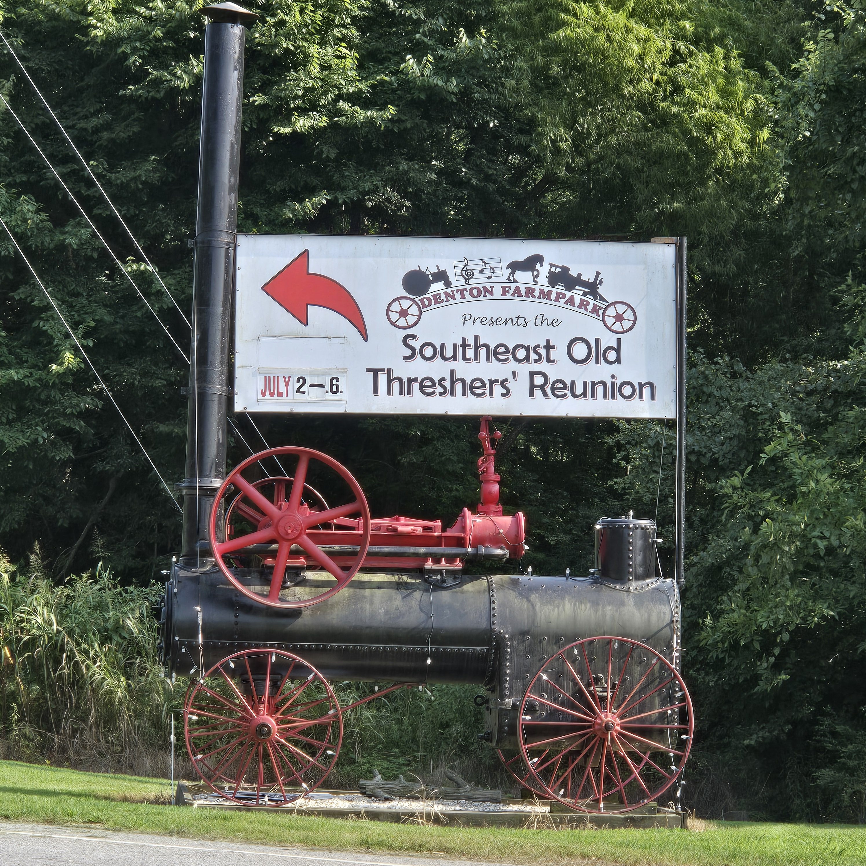
One of Davidson County’s most famous attractions is the annual Lexington Barbecue Festival, held in the city of Lexington during October, bringing in more than 100,000 visitors from across the southeastern U.S. There is also a yearly Davidson County Agriculture Fair held in September. In addition, Thomasville hosts an annual Everybody’s Day Festival, the longest running festival in the state, which also draws about 100,000 visitors each year — about half locals from the Davidson County and half from outside of the county. The Southeastern Old Threshers Reunion is also held every year at the Denton Farm Park.
You’ll l find many year-long attractions in Davidson County, including Historic Uptown Lexington and the Davidson County Historical Museum located in the old courthouse. Alongside the Yadkin River sits Boone’s Cave Park where, according to legend, a young Daniel Boone and his family once lived for over a year while their home was being built. Other attractions include Denton Farm Park and the North Carolina Vietnam Veterans Memorial. The historic Wil-Cox Bridge spanning the Yadkin River has been preserved for pedestrian traffic and is now part of the Yadkin River Park. The Big Chair in Thomasville is also a major landmark — and a popular roadside attraction.
Davidson County is home to many race fans — especially those of Richard Childress Racing, the owner of Dale Earnhardt Sr.’s famous race team. You’ll also find Childress Vineyards and the Richard Childress Racing Museum, housing lots of Dale Earnhardt Sr. race cars and memorabilia.
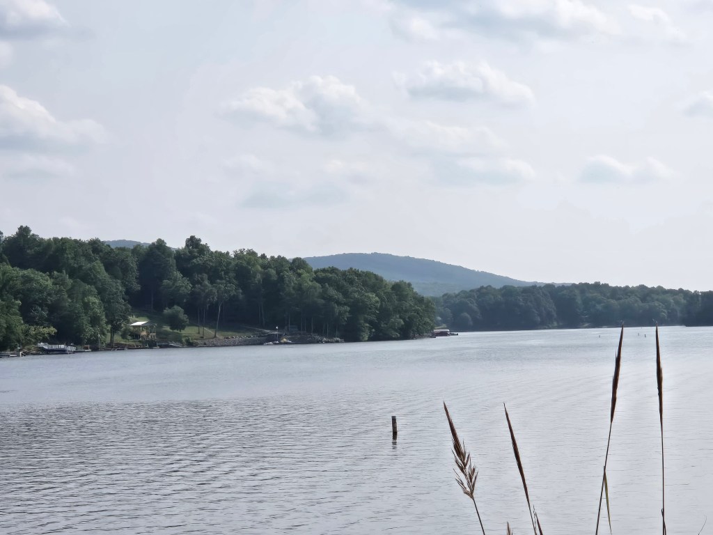
High Rock Lake is the northernmost of the Uwharrie Lakes and the second largest lake in North Carolina behind Lake Norman. Its water surface covers 15,180 acres and there are 365 miles of shoreline. It begins at the confluence of the Yadkin River and the South Yadkin River. It has been the host of the Bassmaster Classic and is the site of frequent other local angling competitions.
Thomasville
An All-American City, Thomasville has been called Chair City or Chair Town as well as the Seat of Hospitality; and it was once notable for its furniture industry, as were its neighbors High Point and Lexington. This Piedmont Triad community was established in 1852 and hosts the state’s oldest festival: Everybody’s Day each year in September.
John Warwick Thomas was born June 27, 1800, and by age of 22 owned 384 acres in the Cedar Lodge area after marrying Mary Lambeth, daughter of Moses Lambeth. By age 30 he was a state representative. In 1848, he became a state senator. He pushed to get a railroad built through Davidson County and invested his own money in the effort. Knowing the railroad was coming, Thomas built the community’s first store in 1852 at present-day West Main and Salem streets, and the community was named Thomasville, for its founder. In 1855, the North Carolina Railroad was built through Davidson County, reaching Thomasville on November 9 of that year. On January 8, 1857, Thomasville was incorporated and occupied one square mile, with the railroad dividing the town into north and south sections.
Long Bill Whiteheart may have been the first to make furniture in the area. He crafted split-bottom chairs at home. D.S. Westmoreland also made chairs at home starting in 1866, and his factory on what became Randolph Street was built in 1879 but burned in 1897 and was never rebuilt. One of the oldest furniture plants was Standard Chair, built in 1898. Other furniture companies included Lambeth Furniture, Thompson Chair, Cramer Furniture, and Queen Chair Company. Thomasville Chair, started in 1904, soon became the town’s leading furniture manufacturer. By 1916, 2,000 chairs a day were being made citywide.
By 1909, Jewel Cotton Mills and Amazon Cotton Mills gave Thomasville another industry: textiles. Sellers Hosiery Mills of Burlington opened in 1913, and Thomasville Hosiery opened in 1916.
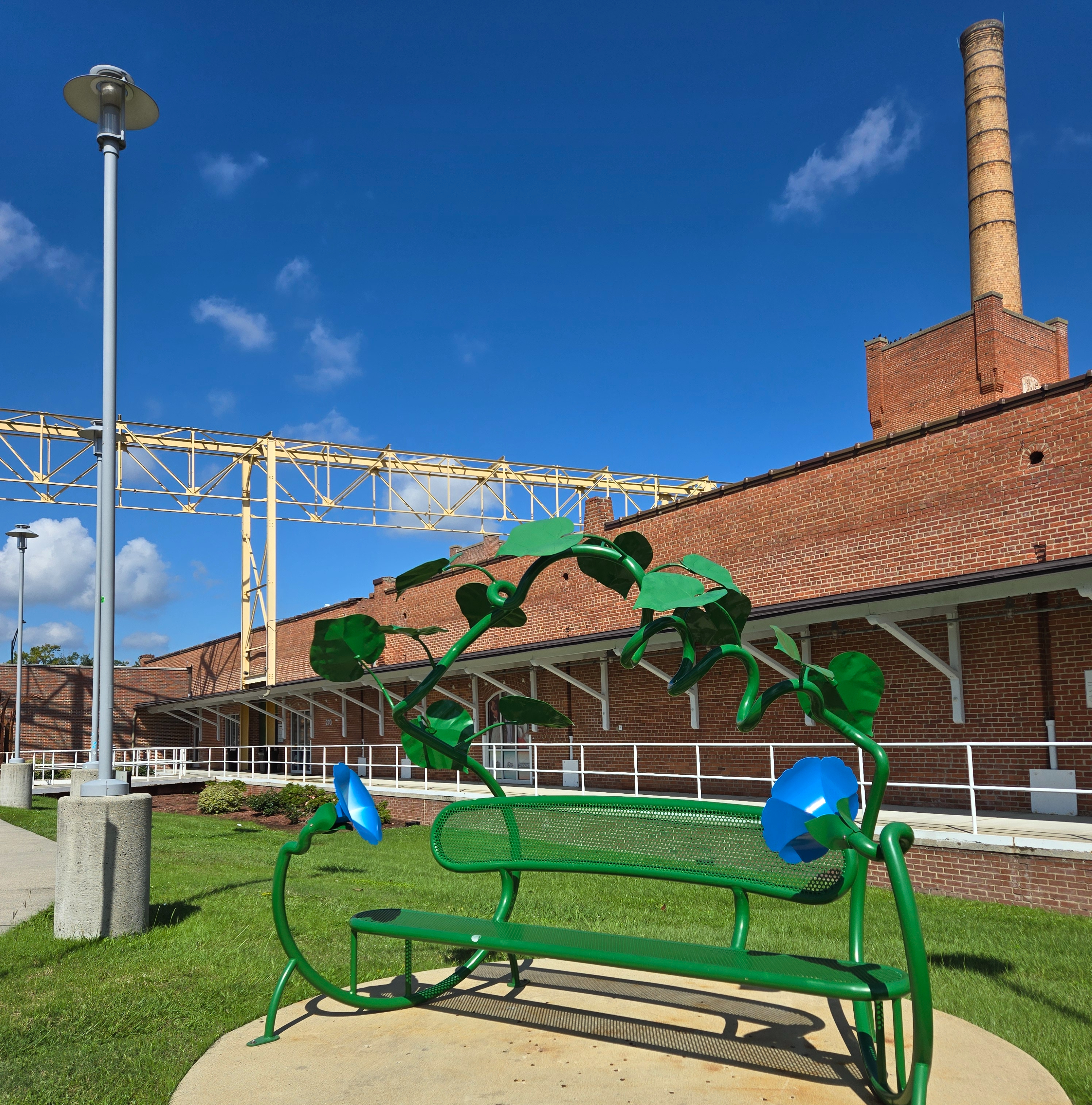
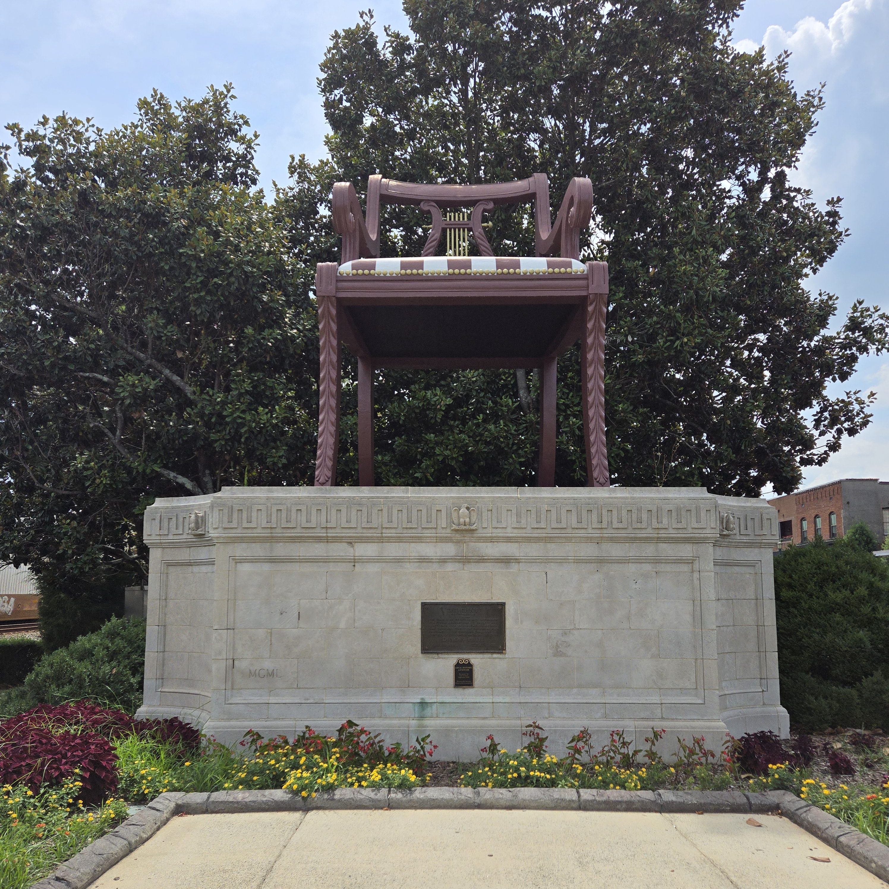
The BIG Chair
Thomasville is commonly referred to as the Chair Town or Chair City, in reference to a 30-foot landmark replica of a Duncan Phyfe armchair that rests in the middle of the city. The original Big Chair was constructed in 1922 by the now-defunct Thomasville Furniture Industries (formerly the Thomasville Chair Company) out of lumber and Swiss steer hide to reflect the city’s prominent furniture industry. However, this chair was scrapped in 1936 after 15 years of exposure to the weather. In 1951, a larger concrete version of the chair was erected with the collaboration of local businesses and civic organizations and still remains today. The Big Chair gained national attention in 1960 when then presidential candidate Lyndon B. Johnson greeted supporters on the monument during a campaign tour whistle stop. Although larger ones have been built, many Thomasville residents still boast that the Big Chair between the two Main Streets is the World’s Largest Chair.
In Thomasville, you’ll also find the large clocktower directly across from the Big Chair, North Carolina’s oldest train depot, the 100% Producers Only Farmers Market, and the NC Vietnam Veterans Memorial. And you can wander around the downtown area on a hunt for 17 public art wall murals as part of the T’ville Mural Project.
Silver Valley
The unincorporated town of Silver Valley is generally accepted to be the site of the first precious metal, silver, found in North Carolina. A colonial road went through Silver Valley, which is now Old NC 10. Gold and silver deposits are a result of geologic faults in the area. Other gold deposits were found further south near El Dorado in what is now Uwharrie National Forest. After land was acquired for Uwharrie in the 1930s, the last American gold rush occurred. Though gold and silver were recovered, the area was never a huge economic success. Around 1900, new silver finds in Silver Valley prompted interest in silver. Just to the North, in the city of Thomasville, a building was constructed for a silver refinery, and the High Point, Thomasville, and Denton railroad was extended to Silver Valley. But before the refinery became active, the silver ran out and the building became Amazon Cotton Mills, which at some point was acquired by Cannon Mills in Kannapolis, NC. The “zon,” as locals referred to the mill, employed many young boys as soon as they turned 16, and offered a special half-shift from 4pm to 8pm to accommodate school work. Silver Valley became a commuter community to Thomasville with workers employed in the many furniture factories and 17 cotton mills until the mills closed with the exodus of textiles and furniture to Asia.
Denton
The founding of Denton may be dated from the time the place acquired a post office, began to be called “Denton” and ceased to be “Finch’s Cross Road”. The General Assembly passed a bill incorporating the town of Denton on March 11, 1907.
The Southeast Old Threshers’ Reunion, described as the largest antique tractor and engine show in the Southeast, takes place during the July 4 holiday at Denton Farm Park, a historical park with several restored buildings. A one-day event with airplane rides later expanded to include displays of farm equipment to give people something to do while they waited — and to teach about the history of agriculture in the area. As of the 48th annual event in 2018, more than 50,000 attended from across 20 states; the five-day event includes hundreds of vendors, train and helicopter rides, musical performances, and fireworks.
Denton also hosts an Antiques Festival and Denton Street Festival each year.
Denton Farm Park 1072 Cranford Rd
High Rock/High Rock Lake
Churchland / Boone’s Cave Park Churchland is home to Boone’s Cave Park (3552 Boones Cave Rd. in Churchland). The 110-acre state park is named after America pioneer Daniel Boone. The entire Boone family came to this area in 1755, when Daniel would have been approximately 15 years old at the time. They reportedly lived in the cave or approximately one year while cabins for the group were being built. There has never been any proof of a Boone cabin on park property, although a foundation was found at an unmarked location, but no direct or confirmed connection to the Boone family could be made. There are, however, copies of many land grants in the Boone family name surrounding what is now park property. (Daniel’s brothers, uncle, and father were all land owners.) The park itself offers 6 miles of hiking trails plus fishing and limited camping. The cottonwood tree on park property is the third largest on record in the state at 169 feet tall, more than 16 feet around the trunk, with a 109-foot-wide canopy.
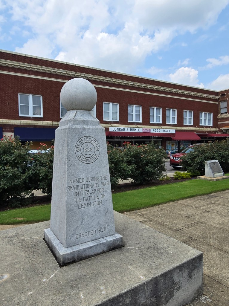
Lexington
The Lexington area was at least sparsely settled by Europeans in 1775. The settlers named their community in honor of Lexington, Massachusetts, the site of the first skirmish of the American Revolutionary War. Lexington was incorporated as a city in 1828. Silver Hill Mine, located a few miles south of Lexington, opened in 1838, and was the first operating silver mine in the country.
Lexington has been noted as one of America’s top four best cities for barbecue by U.S. News & World Report. The City calls itself the Barbecue Capital of the World. Since 1984, the city has hosted the Lexington Barbecue Festival, one of the largest street festivals in North Carolina. As of 2003, the city has over 15 barbecue restaurants, an average of more than one per thousand residents. Both the art initiative Pigs in the City and the Lexington Barbecue Festival bring in tourists from all over the country.
Lexington-style barbecue is made with pork shoulder cooked slowly over a hardwood fire, usually hickory. It is basted in a sauce (called “dip” locally) made with vinegar, ketchup, water, salt, pepper and other spices. The ingredients vary from restaurant to restaurant, with each restaurant’s recipe being a closely guarded secret. While each is vinegar-based, the taste varies widely from tangy to slightly sweet or spicy. The most distinguishing feature of the Lexington Barbecue Sandwich is the inclusion of red slaw (sometimes called barbecue slaw). Red slaw is a combination of cabbage, vinegar, ketchup, and crushed/ground black pepper; it is distinguishable from coleslaw because it contains no mayonnaise.
The oldest surviving house in Lexington is The Homestead, built by Dr. William Rainey Holt (1798–1868), a physician born in what is today Alamance County.
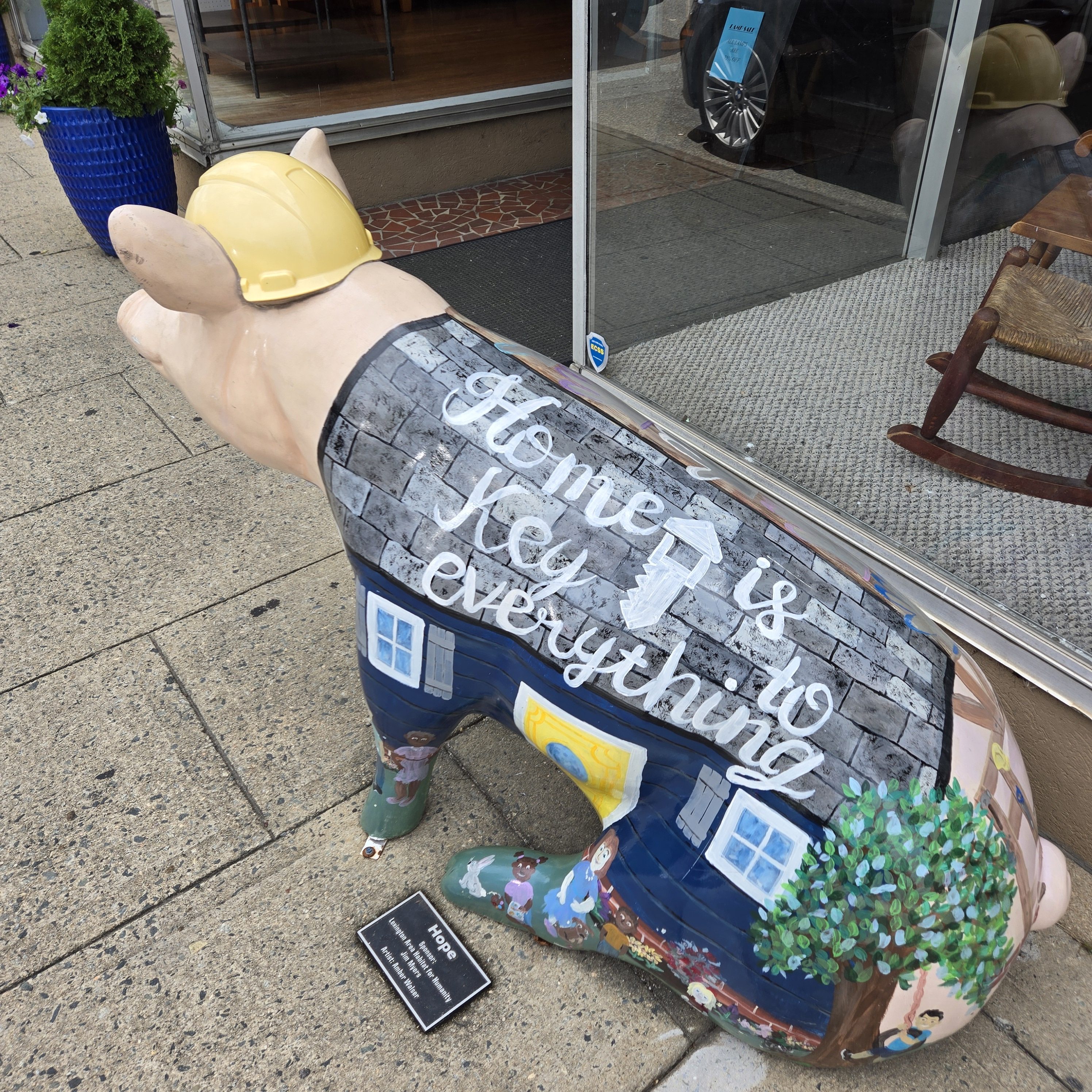
Pigs in the City
Pigs in the City is a public art initiative coordinated by Uptown Lexington, Inc., a nonprofit organization created to revitalize the downtown (locally called “uptown”) area of Lexington. People paid commissions to artists to decorate life-sized sculptures of pigs, which were installed throughout the city. Pigs in the City began in 2003, and the event drew more than 40,000 visitors from all over the state in its first year.
Davidson County Historical Museum Housed in the old Greek Revival structure of the Davidson County Courthouse, the Davidson County Historical Museum (2 South Main St.) features a permanent collection of the area’s natural and cultural history.
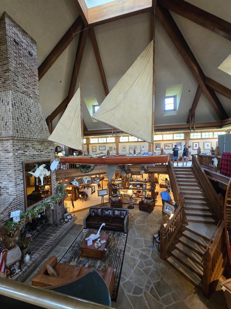
Bob Timberlake Gallery The Bob Timberlake Gallery (1714 E Center Street EXT) invites visitors to peak into the artist’s life and shop for Timberlake accessories as well as originals and prints of his world-famous realist paintings showcasing the simple life in North Carolina with highly-detailed and colored paintings. His work has been exhibited in galleries the world over. Timberlake still lives in his childhood home in Lexington, NC. The gallery hosts many special events throughout the year, some featuring local artists, including the annual Christmas in July Event.
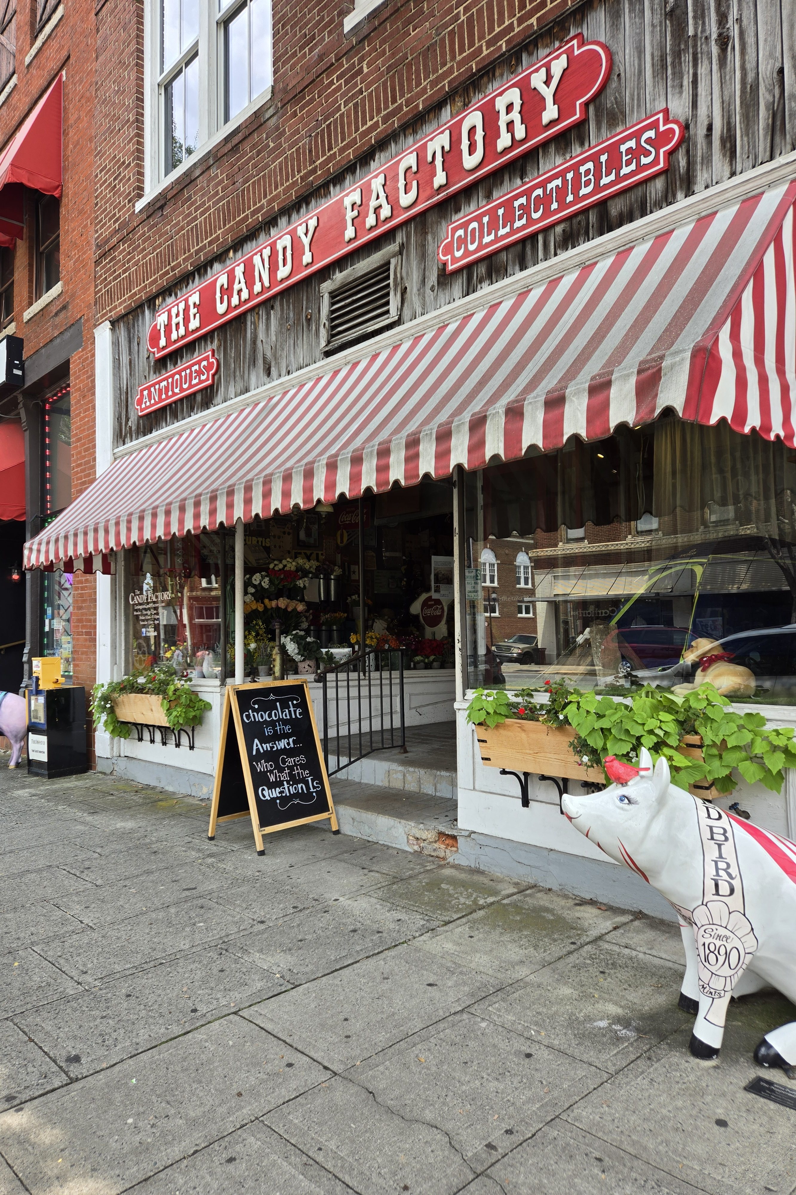
The Candy Factory
No trip to Lexington is complete without a visit to the old-timey, historic Candy Factory, complete with creaky wooden floors. With a classic red-and-white awning, this community gem is a destination for candy lovers — modern and nostalgic alike. Here, you’ll find classic candies from the 50s, 60s, 70, 80s, and 90s as well as house made chocolates and decadent treats, plus 50+ sugar-free candies too. Stop by for your favorites as well as an array of seasonal and holiday goodies too.
Childress Vineyards Spend a few hours perusing the grounds and buildings at the Tuscany-inspired Childress Vineyards (1000 Childress Vineyards Rd.). The vineyard grows, harvests, barrels, and bottles its own European grape varietals. Enjoy daily lunch at the Bistro, try a wine tasting, and shop in the huge gift shop. Weddings and private and corporate events are also held here. They’re touted as one of America’s top 25 tasting rooms!
Welcome
The town motto is “Welcome to Welcome, A Friendly Place,” as posted on the welcoming sign.
Richard Childress Racing and the RCR Racing Museum If you’re a NASCAR fan and/or a Dale Earnhardt fan, Richard Childress Racing and the RCR Racing Museum (on Industrial Dr.) is a must-see. You’ll encounter larger-than-life-size portraits of Dale Earnhardt, see many of his classic race cars on display, see video of the hero himself speaking, relive a bit of the past, and even take a peak into Richard Childress’s own office, where many a deal has been hammered away and signed. And it’s more than just a memorial to Dale, the museum’s footprint also displays vehicles from the truck series, trophies, and more. You’ll also have the opportunity to walk through one of the Goodwrench haulers and see the many countless signatures of fans, who paid homage to the late racer. Through some miracle, this blogger somehow found her own signature among the thousands on display!
Weathervane Winery 1452 Welcome Arcadia Road
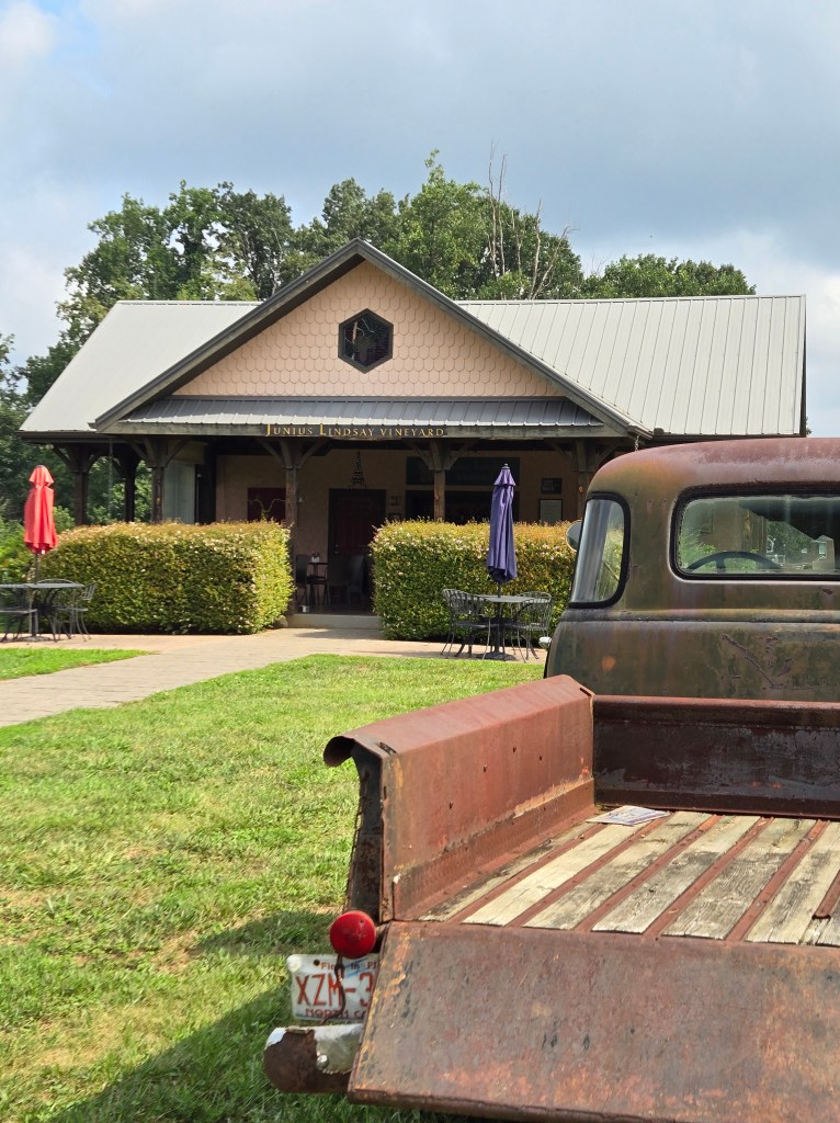
Arcadia
Junius Lindsay Vineyard 385 Dr Zimmerman Rd
Midway
Midway derives its name from its geographic location, “midway” between the cities of Winston-Salem and Lexington. However, urban sprawl and annexation by the city of Winston-Salem has moved the city limits of Winston-Salem, which now borders Midway, while Lexington’s nearest border is 7 miles away. The Town of Midway, located in the northern section of Davidson County, North Carolina was incorporated on June 29, 2006. Midway is Davidson County’s fifth and newest incorporated municipality. At the time of formation, the town encompassed eight square miles with a population of 4,399. After citizens requested annexation, Midway now covers nine square miles with a population of 4,700. Every autumn, the town hosts the Midway Christmas Parade in celebration of the coming Christmas season. NASCAR drivers and brothers Terry Labonte and Bobby Labonte are from the area.
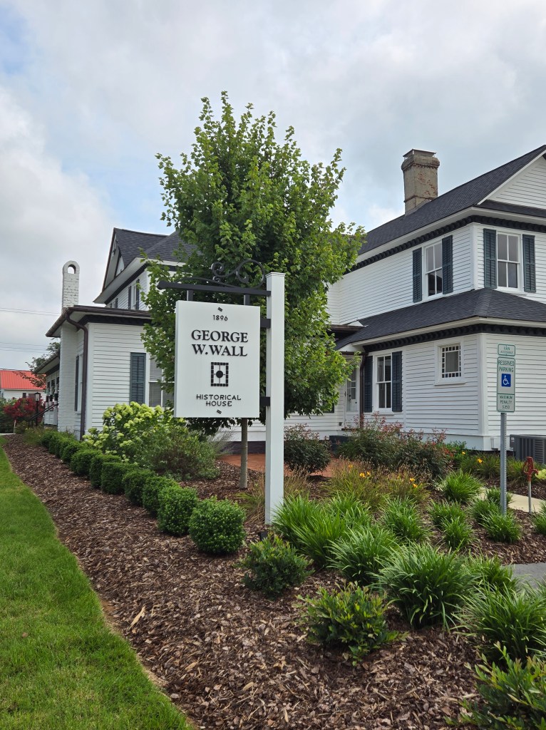
Wallburg
The Wall family played a prominent role in the settlement of the community in northeast Davidson County. In 1860 Samuel W. Wall the second generation of the family in the area began a coach-making business with $600 worth of capital investment and three employees, producing 10 buggies and carriages worth $1,100 annually.
Two of Samuel’s sons, Charles Moses and George, founded their own firm, the Wall Lumber Company, in the late 1880s, and began to prosper by providing processed lumber to the Lexington and High Point furniture companies. Their saw and planing mill transformed the raw lumber purchased from local farmers into planks, wooden boxes, and some finished products, such as couch frames.
The George W. Wall House
In 1888, George W. Wall married Hattie Charles and made his first land purchase, a 40-acre tract, which he purchased from his father for $400. George and Hattie built a plain two-story frame house on their land and began their family. By 1896, both the family finances and family size had increased to the point that a new residence was constructed. The first house was moved to an adjacent site, and between July and December of that year the present Wall residence was built.
The two houses now occupy adjacent corners of the intersection of N.C. 109 and the Motsinger Road. All building supervision was apparently done by George himself, using local workmen. The lumber most likely came from the family company. According to family tradition, the stained-glass windows were ordered from High Point, and it is likely that much of the woodwork, including the doors, moldings, and some of the mantels, came from the factory as well. Hattie is said to have designed the woodwork, and Turner Wall, who worked with his brothers in the lumber company, is credited with the construction of the most ornate features, such as the staircase and some of the mantels. George and Hattie raised 11 children in the house, and lived there until their deaths in 1943 — only six weeks apart.
If I could associate a color with Pitt County, it would most certainly be purple, as Greenville in Pitt County is home of the Eastern Carolina University (ECU) pirates. In addition to having a college town metropolis, you’ll also find a plethora of farmland, including tobacco, corn, dense pine forests, tobacco farms, and fertilizer mining in this silty, sandy-soiled inner banks county.
Named for William Pitt the Elder, who was then Secretary of State for the Southern Department and Leader of the House of Commons, Pitt county was formed in 1760 from Beaufort County (though the legislative act that created it did not become effective until January 1, 1761). William Pitt, Earl of Chatham, was an English statesman and orator, born in London, England, UK. He studied at Oxford University and in 1731, Pitt joined the army. Pitt led the young “Patriot” Whigs and in 1756 became secretary of state, where he was a pro-freedom speaker in British Colonial government.
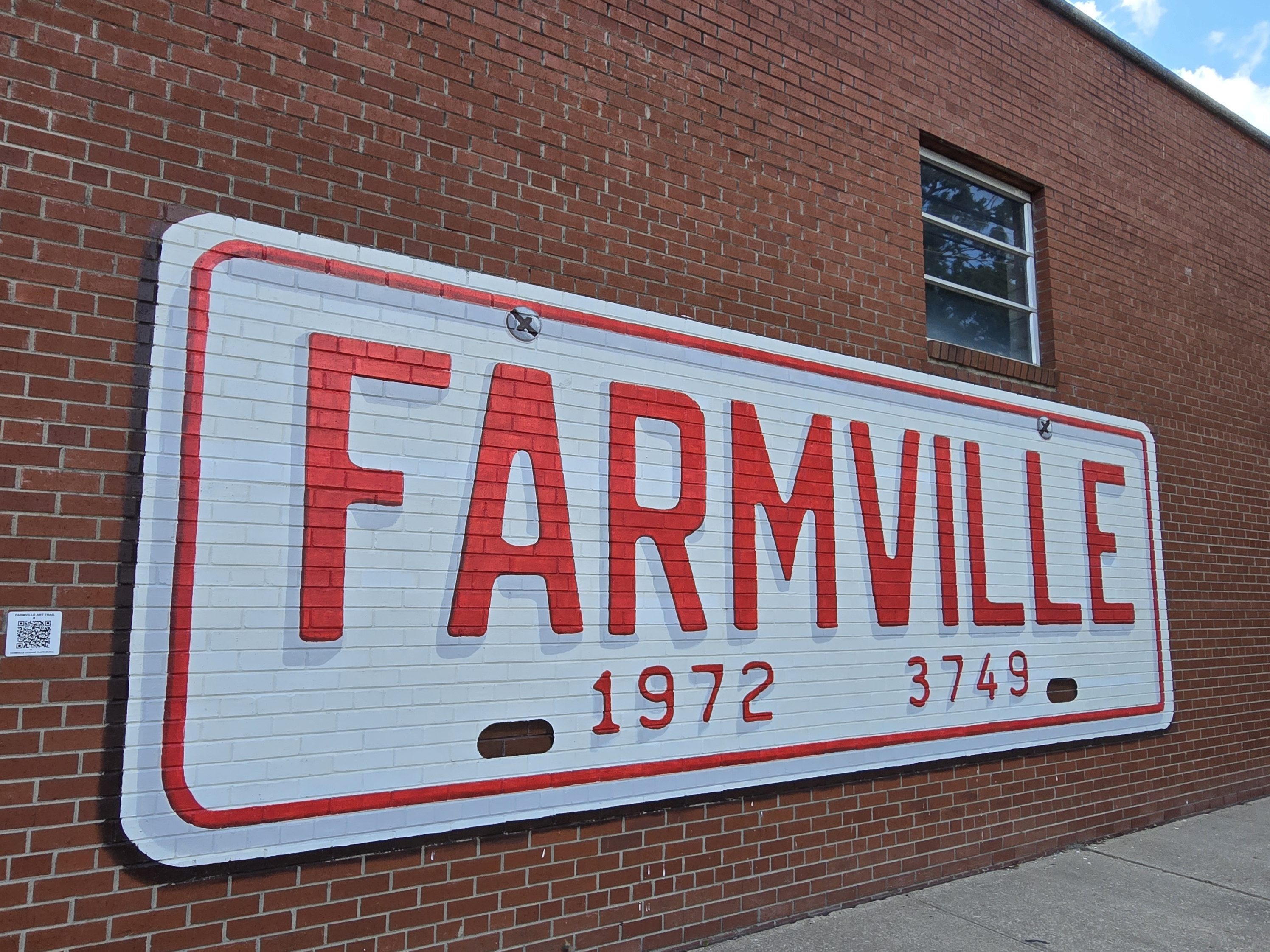
Farmville
Established in February 1872, the town was named Farmville because all of its undertakings and activities were farm related. Farmville has been a Tree City USA community through the Arbor Day Foundation for 36 years, proving its commitment to managing and expanding its public trees. The Town government, in cooperation with other non-profit groups that work for the advancement of the town, sponsor annual events such as the Farmville Dogwood Festival, the Christmas Parade, Independence Day Celebration, A Taste of Farmville, and the Holiday Open House, among others.
You’ll find the East Carolina Art Space (3747 Main St.) and North Carolina Furniture School (3749 W. Wilson St.) here in Farmville. Singer Roberta Flack taught music in Farmville.
Paramount Theater The famous Paramount Theatre (3723 Main St.) is at the center of Farmville’s cultural life. The Theater Building has always served the entertainment needs of Farmville since it was built as a traditional Movie theater in the 1920s. The theater regularly hosts dramatic plays, comedies, musicals, the occasional seasonal movies, visual art shows, and concerts from symphonies to rock bands and everything in between. When in town, check their calendar of events to see what’s on tap at the Paramount!
Farmville Art Trail
The Farmville Art Trail is a free, self-guided tour within downtown Farmville highlighting the town’s many public art installations and arts organizations. The Art Trail meanders through downtown Farmville stretching from the Community Center to the Oliver Murphey Park. It showcases larger-than-life murals, ghost signs, sculptures, galleries, and studios, with opportunities to shop and eat along the way. Each stop along the Art Trail is accompanied by a QR code which connects to audio recordings by the artists and local experts. The QR codes are strategically placed on utility poles or marker stands each point of interest. Maps are available at the Farmville Public Library.
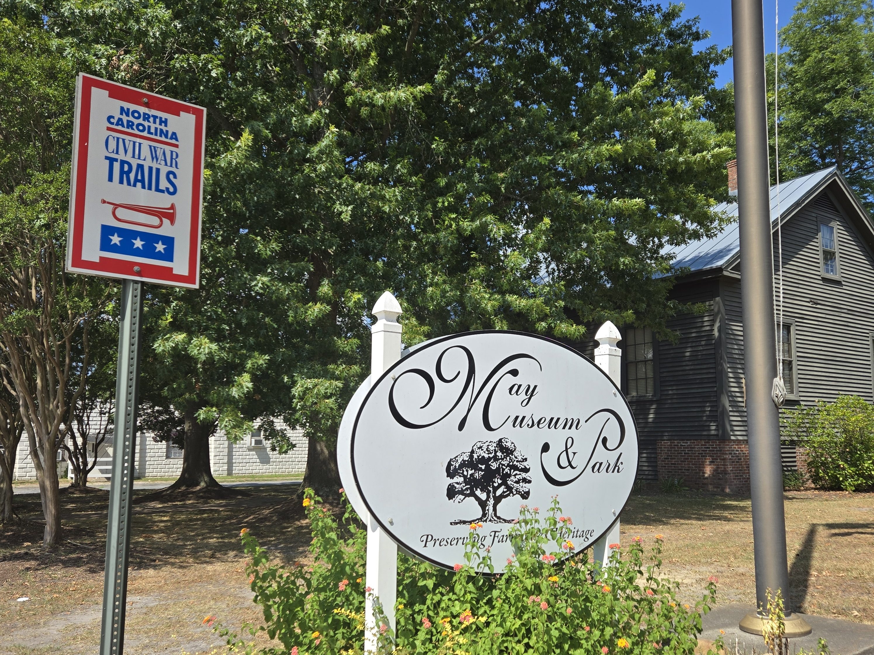
May Museum The May Museum (3802 S. Main St.) occupies an 1850s-era home and is listed on the National Register of Historic Places. Its extensive archival holdings consist of approximately 10,000 photographs, 20,000 records, and 10,000 artifacts, including May family correspondence, maps, commercial and legal records, postcards, scrapbooks, and more. Examples of period furniture, glassware, agricultural implements, militaria, and a variety of domestic life items comprise a great portion of the museum’s artifacts.
Bethel
Confusingly, there are three other towns in the state named “Bethel.” One is between Edenton and Hertford in the “Finger Counties” region in the northeastern corner of the state, another is in the north-central part, in Caswell County and the third is located in the Mountain Region of North Carolina, in Haywood County. There is also a community named Bethel located in Watauga County.
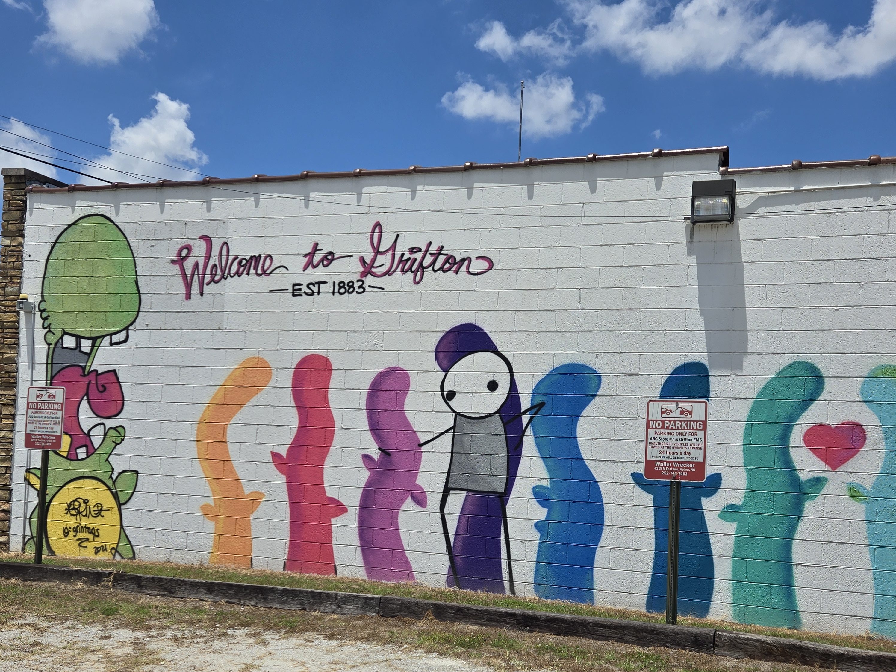
Grifton
Settlement in the Grifton area dates back to 1756, when the locale was known as Peter’s Ferry. By 1764, it was known as Blount’s Ford. In the 1800s according to local knowledge, the Contentnea Creek bridge was set ablaze during the Civil War, prompting Mr. Coward to construct a replacement bridge in 1867. However, this bridge had a short lifespan, leading Franklin Bell, a nearby blacksmith and chairmaker, to operate a ferry across the creek. As a result, the location earned the name Bell’s Ferry, which persisted even after the county erected a fresh bridge over the creek in 1869. It was incorporated under that name in 1883. The name was formally changed to Grifton six years later to honor local merchant C. M. A. Griffin. Soon thereafter, it became styled as Grifton. The town of Grifton holds an annual Shad Festival as well as John Lawson Legacy Days.
Atlantic Coast Line Depot Grfiton’s Atlantic Coast Line Depot still stands at 485 Queen Street. In the late 19th and early 20th centuries, the railroad played a major role in the life of Grifton. Primarily agricultural supplies and pulpwood travelled through the town on the rail line operated by Atlantic Coast Line, a US Class I railroad from 1900 until 1967. Currently CSX owns and operates the rail line.
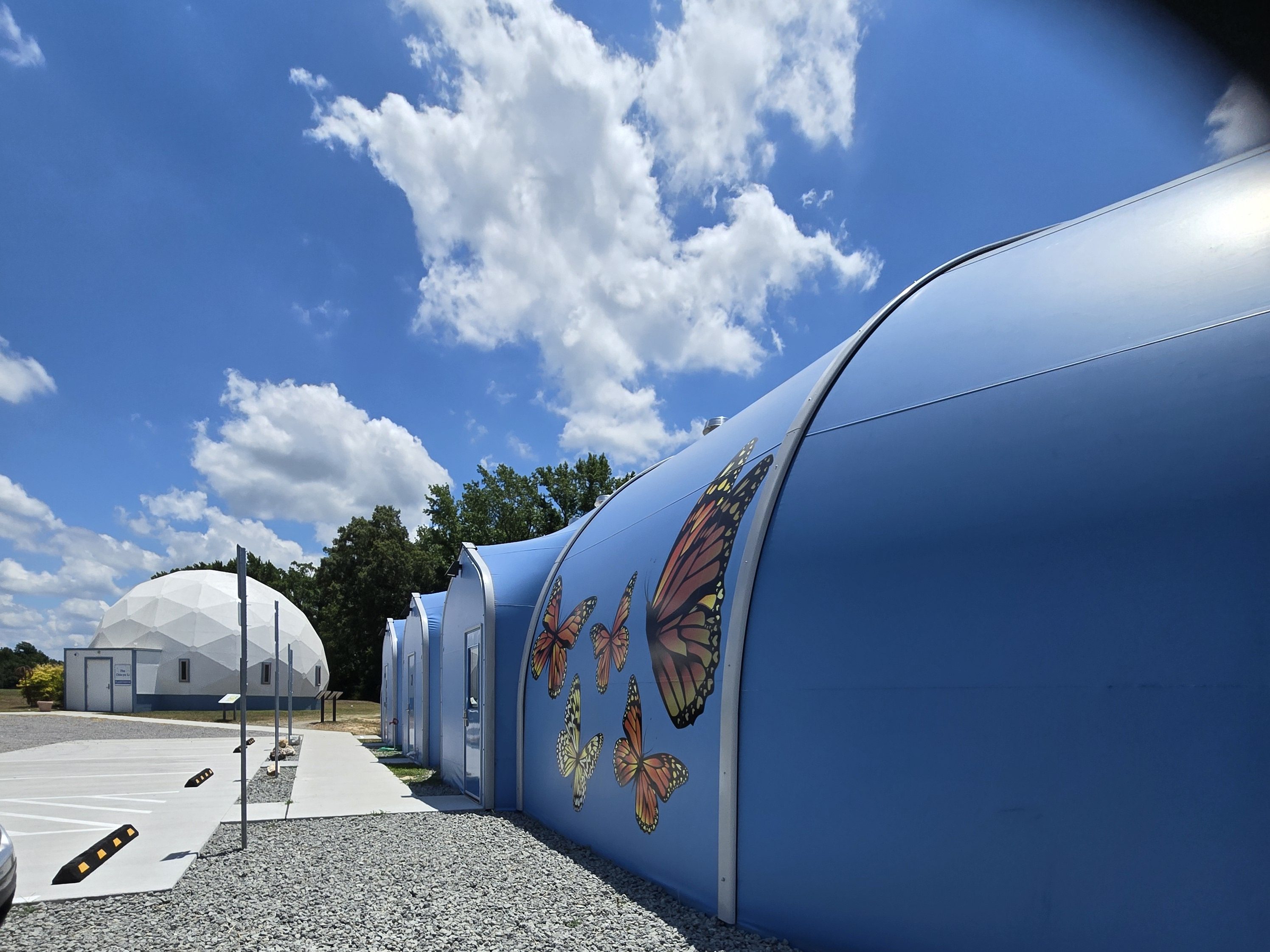
North Carolina Museum of Natural Sciences – Contentnea
The North Carolina Museum of Natural SciencesContentnea Creek location (949 Contentnea Lane) features the Chia-Yu Li Planetarium, a 35-foot geodesic dome powered by a Digitarium Zeta Digital Planetarium System, as well as wildlife exhibits and some live animals and reptiles as well.
Ayden
In 1891, William Henry Harris asked the Atlantic Coast Line Railroad to build a railroad depot on a portion of his farm in order to create a village. A 40-acre parcel of land was divided into residential lots surrounding the depot in “Harristown,” with Harris owning every other lot. Within the next several years, lots were sold and homes built. Businesses began to open up to support the new residents, and on February 3, 1891, the town was incorporated as “Ayden.” By 1919, Ayden had full-time electricity supplied by the Ayden municipal light plant. After the Great Depression and the Second World War, the town began to grow. To accommodate the growth, commercial, cultural, religious, and other establishments were opened within and around Ayden. The community is still growing today, due to the continued development of Greenville as an industrial and economic center for eastern North Carolina.
Winterville
YouTuber and philanthropist Mr. Beast (Jimmy Donaldson) is from this area.
Greenville
Greenville is known as “The Emerald City” and “the gem of the east.” The city is also Eastern Carolina University (ECU)/pirate territory, hence it is decked out in purple. Even several national and regional businesses, such as Truist Bank, have changed their logo and signage to purple in this city.
Greenville formed in 1771 as “Martinsborough,” named after the Royal Governor Josiah Martin. In 1774, the town was moved to its present location on the south bank of the Tar River, three miles west of its original site. In 1786, the name was changed to Greenesville in honor of General Nathanael Greene, the American Revolutionary War hero. It was later shortened to Greenville.
*Note that Greensboro, North Carolina, is also named for General Nathanael Greene.
During Greenville’s early years, the Tar River was a navigable waterway, and by the 1860s there were several established steamboat lines transporting passengers and goods on the river. Cotton was the leading agricultural crop, and Greenville became a major cotton export center. Before the turn of the century, tobacco surpassed cotton and became the leading money crop. Greenville became one of the state’s leading tobacco marketing and warehouse centers.
For more than a century, Greenville was recognized only as an important tobacco market and the home of a small, state-supported college, chartered by the Legislature in March 1907. By the mid 1960s, East Carolina College had become the third-largest state-supported college, and enrollment approached 8,000 students — twice the 1960 enrollment figure. In 1967, it became East Carolina University. ECU Medical School admitted its first four-year class in 1977. At the turn of the century, enrollment at ECU topped the 18,000 mark, and now exceeds 29,000 students.
In September 1999, Hurricane Floyd made landfall in eastern North Carolina, dropping nearly 17 inches of rain. Many residents were not aware of the flooding until the water came into their homes. Most localized flooding happened overnight, and the Tar River suffered the worst flooding, exceeding 500-year flood levels along its lower stretches. An additional 20+ inches of rain had fallen in the previous month due to two passes of Hurricane Dennis. Damages in Pitt County, alone were estimated at $1.6 billion. Some residents in Greenville had to swim six feet underwater to reach the front doors of their homes and apartments.
Actor and producer Sandra Bullock was an ECU graduate, and Wilber Hardee, the founder of Hardee’s, is from the area.
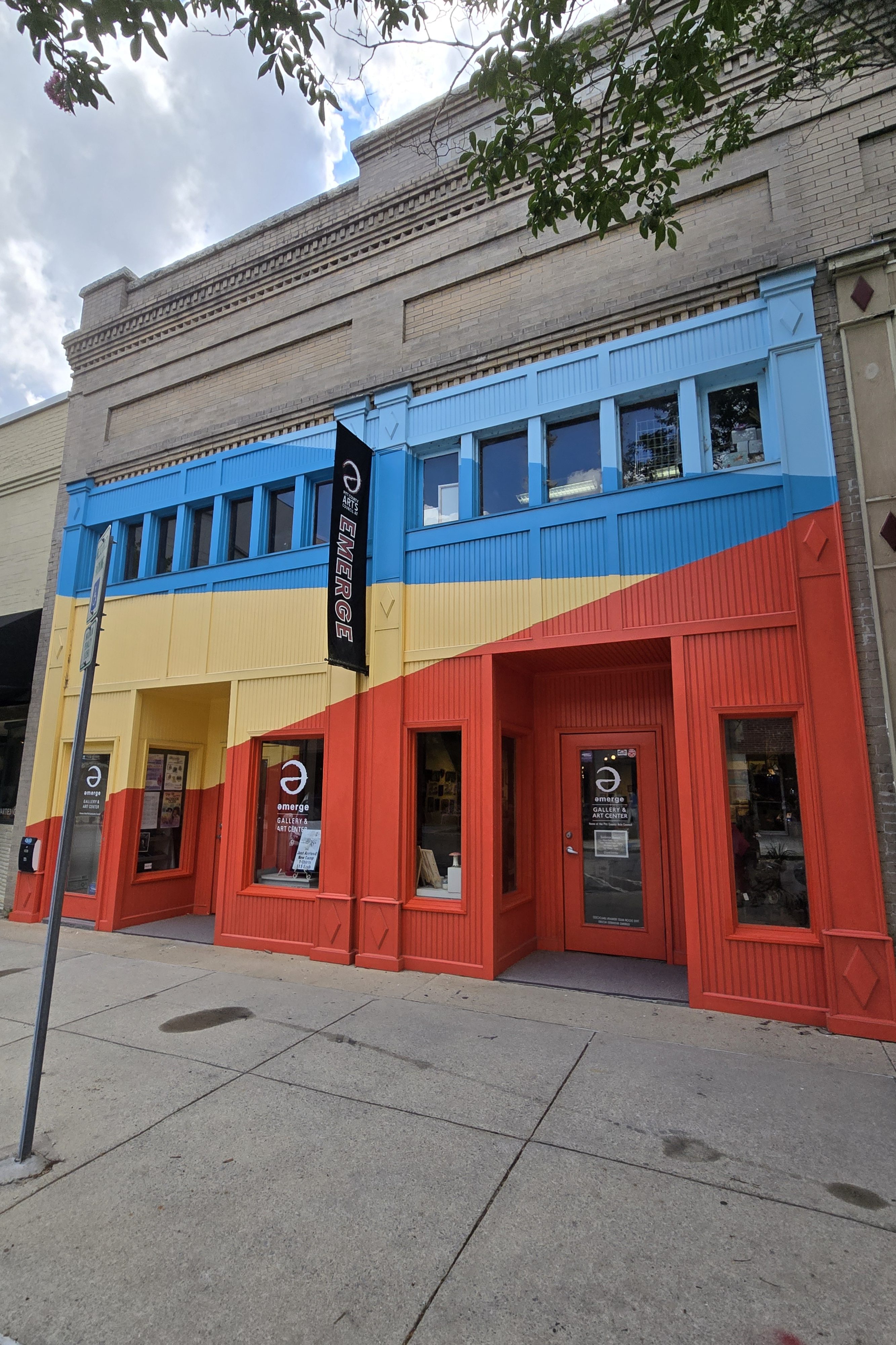
Emerge Gallery and Art Center Stop by the Emerge Gallery and Art Center (404 South Evans St.) for a peek at a variety of eclectic art from different area artists.
Greenville Museum of Art For more than 80 years, the Greenville Museum of Art (GMoA) at 802 South Evans St., has served the community as an advocate center for artists far and wide, while also providing the community access to the arts. The museum holds six galleries of rotating art displays.
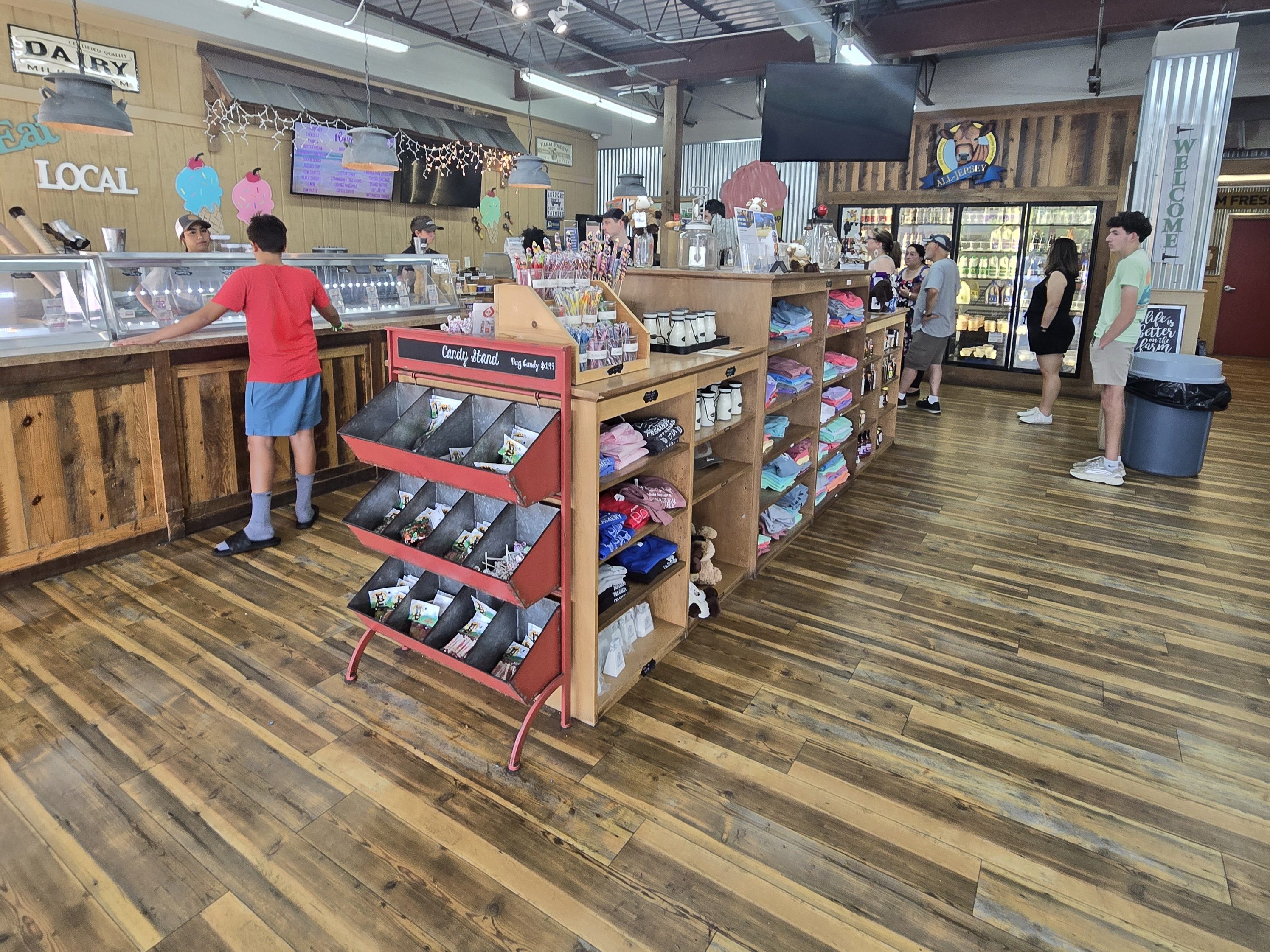
Simply Natural Creamery
While in Greenville, we recommend stopping by Simply Natural Creamery (317 E. Arlington Blvd.), which serves up Jersey Cow ice cream, milk, and other products — said to be the ‘Cadillac of Milk’ — because the milk does not contain the protein that causes lactose intolerance. So, enjoy to your heart’s content and bring a cooler to take some milk home with you.
Wilkes is also one of the 27 North Carolina counties which the Blue Ridge Parkway runs through. Here you’ll discover lots of farms and orchards along your drive as well as surprising mountain vistas and bountiful scenic overlooks.
The county was formed from parts of Surry County and was named for the English political radical John Wilkes, who lost his position as Lord Mayor of the City of London due to his support for the colonists during the American Revolution. Over several years Wilkes County was subdivided, or boundary adjustments were made, to form all or part of Ashe County, Caldwell County, Alexander County, and Watauga County.
Wilkes County was once known as the “Moonshine Capital of the World,, and was a leading producer of illegal homemade liquor. From the 1920s to the 1950s, some young Wilkes County males made their living by delivering moonshine to North Carolina’s larger towns and cities. Wilkes County natives also used bootleg liquor as a means for barter beyond the borders of North Carolina. Many Wilkes County distillers ran white liquor as far as Detroit, New Jersey, and South Florida. Since this often involved outrunning local police and federal agents in auto chases, the county became one of the birthplaces of the sport of stock-car racing.
Despite its rural character and relatively small population, Wilkes County has been the birthplace of numerous large industries. Lowe’s, the second-largest chain of home-improvement stores in the nation (after The Home Depot) began in Wilkes County in 1946. And until 2003, Lowe’s had its corporate headquarters in Wilkes County, but the company has since relocated most of its corporate functions to Mooresville, North Carolina, a fast-growing suburb of Charlotte. However, Lowe’s large office in Wilkesboro still houses many corporate departments, and Lowe’s remains the county’s second-largest employer.
Other industries which started in Wilkes County include Lowes Foods (now headquartered in Winston-Salem — and started by the same Lowe’s family as Lowe’s Home Improvement). The Carolina Mirror Company in North Wilkesboro, founded in the 1930s, was for many years the largest mirror factory in America. Today Gardner Glass Products Inc. still produces mirrors in North Wilkesboro. Holly Farms, in Wilkesboro, was the largest poultry producer in the Southeastern United States until it was bought by Tyson Foods in 1989. Wilkes County remains one of the largest producers of poultry in the Eastern United States, and many of the county’s farmers are poultry farmers for Tyson Foods, which is the largest employer in Wilkes. On your travels you may pass by numerous Tyson chicken facilities — with numbered signs at the street. In fact, Wilkesboro’s largest industry is the Tyson Foods poultry processing plant, and it has one of the largest poultry plants east of the Mississippi River.
Wilkes County is part of the Yadkin Valley AVA, an American Viticultural Area. Wines made from grapes grown in Wilkes County may use the appellation Yadkin Valley on their labels. With the decline of tobacco farming, some Wilkes County farmers have switched to wine-making, and have hired experts from Europe and California for assistance. As a result, wine-making has grown in popularity in both Wilkes and surrounding counties. In May of each year, Wilkes county celebrates the new wine industry with the Shine to Wine Festival, held in downtown North Wilkesboro.
Wilkes County is also home to the annual Brushy Mountain Apple Festival, which is held in downtown North Wilkesboro the first weekend in October. The festival, which attracts more than 160,000 visitors each year, is one of the largest single-day arts and crafts fairs in the Southern United States. Carolina in the Fall is another music festival each September in the Historic Downtown Wilkesboro area.
In 1988 legendary, Grammy-winning folk music guitarist Doc Watson and Bill Young started the Doc Watson Festival (later renamed the MerleFest music festival) in Wilkesboro. Held on the campus of Wilkes Community College and named in honor of Doc’s late son Merle Watson, MerleFest has grown into one of the largest folk and bluegrass music festivals in the United States, drawing an average of over 75,000 music fans each year and attracting big name stars, such as James Taylor. The festival has become the main fundraiser for the college, and brings more than $10 million in estimated business and tourist revenues to Wilkes County and surrounding areas each year.
While passing through the county, you may catch one of the 16 quilts considered part of the Wilkes Barn Quilt Trail.
Notable People Connected to Wilkes County
Daniel Boone (1734–1820), explorer and pioneer, lived in Wilkes County for several years and married a Wilkes County native before moving west to Kentucky.
Chang and Eng Bunker (1811–1874), Siamese twins, who were a popular attraction in Asia, Europe, and North America in the nineteenth century, settled in Wilkes County in the 1850s, married two local sisters, and between them fathered 21 children.
Deneen Graham (born 1964), the first black woman to be crowned Miss North Carolina in 1983.
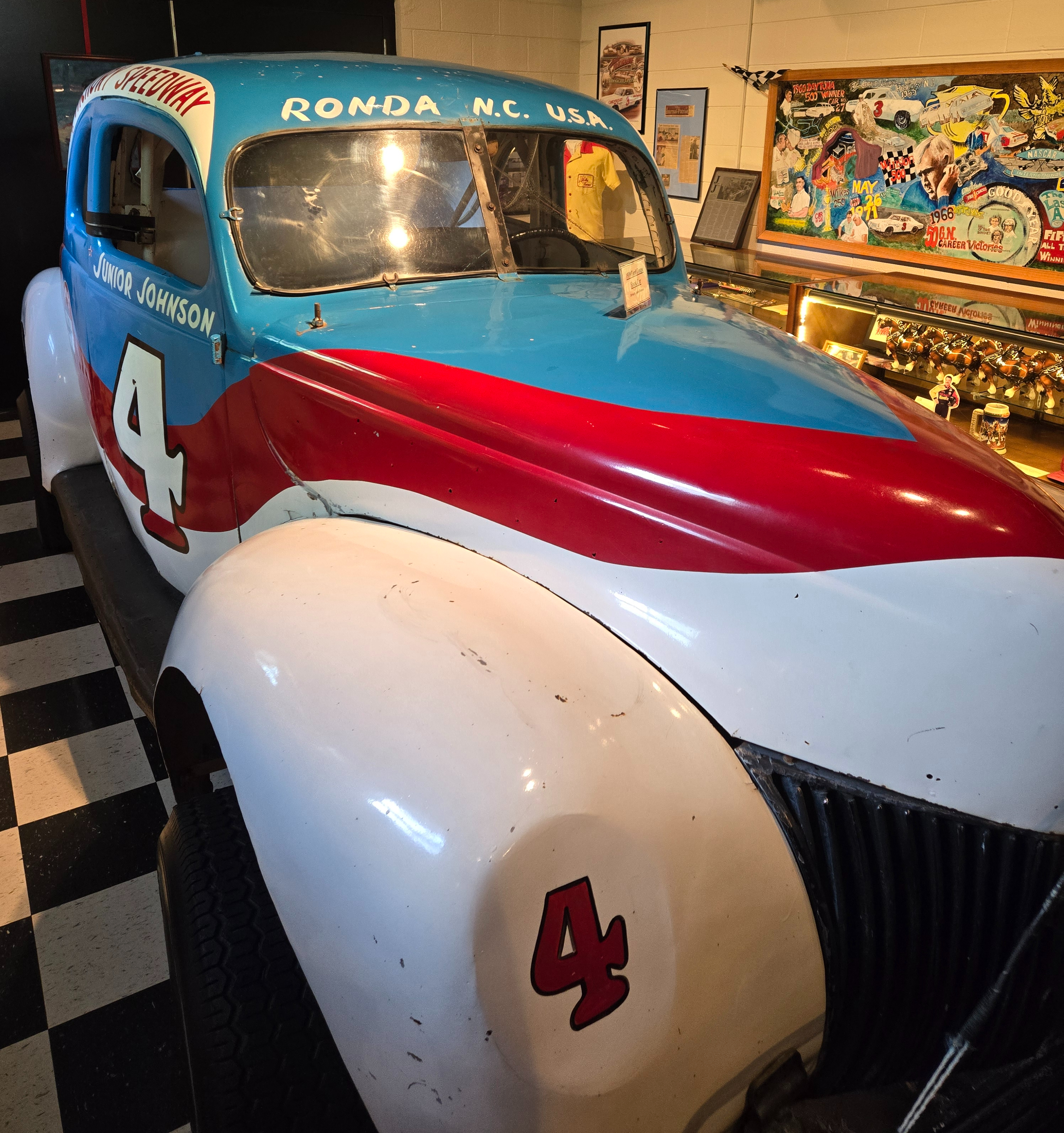
Junior Johnson (1931–2019) became a legend in the 1950s rural South by consistently outrunning law-enforcement officials in auto chases while delivering homemade liquor (moonshine) to his customers. Johnson then became a champion NASCAR racer, winning 50 NASCAR races before his retirement.
Lucius Smith Lowe (1879–1940) is the founder of North Wilkesboro Hardware, which later became the home improvement giant Lowe’s Home Improvement
James Lucius Lowe (1918–1965) is the founder of Lowes Foods and also the son of Lucius Smith Lowe, co-owner of Lowe’s Home Improvement.
Benny Parsons (1941–2007), is a NASCAR racer who won the 1973 NASCAR championship. After his retirement, he became a longtime TV racing analyst.
Morgan Shepherd (born 1941), NASCAR driver for more than 50 years; oldest driver to lead at least one lap in a NASCAR race. He currently owns his own team in the NASCAR Xfinity Series as the Shepherd Racing Ventures team.
Moravian Falls
The town of Moravian Falls is located in the heart of Wilkes County, North Carolina, and sits at an elevation of 1,192 feet. Deriving its name from its 35 foot waterfall and the Moravian brothers who settled here in 1753, Moravian Falls could be the perfect setting for your mountain vacation.
In 1752, in the backwoods of North Carolina the Moravians purchased a tract of almost 100,000 acres . The name of the tract became known as Wachovia. In 1766, they establish the town of Salem (meaning “peace”), which is often confused with Salem, Mass.
The Moravians established a rooted community with strong values and stable trade.
The Moravian Falls
The falls are located on the grounds of the Moravian Falls Campground. From US Highway 421, exit onto NC Highway 18 and NC Highway 16. Follow NC 18/16 south to the town of Moravian Falls, bearing right to stay on NC 18. After 0.4 miles, turn left onto Falls Rd. and go 0.5 miles to see a view of the falls on the left. Please do not slow down or block traffic to view them, as traffic may come down the hill at a good speed. There is a small turnoff area across from the falls, and you can pull in there for a quick view. Visitors are required to obey all rules at the campground concerning the Falls and are not allowed to swim near or above the falls.
Ferguson
Whippoorwill Academy & Village Edith Carter started this Whippoorwill Academy & Village (11928 NC Hwy 268 W Ferguson) with her husband, Hill, to preserve a part of the area’s rich history. Edith, a retired teacher, was driven to educate visitors about the events that have taken place and shaped the Yadkin Valley. The village is open one Saturday a month and during the week for school groups. They offer tours and activities that provide out-of-the-classroom learning opportunities for students of all ages.
Whippoorwill is located on the Ferguson family farm (circa 1700s) and consists of a group of 12 buildings (mostly log cabins). There is a museum dedicated to Tom Dooley (of “Hang Down Your Head, Tom Dooley” fame), who lived in the area before his hanging back in the 1800s. There are also two cabins dedicated to Daniel Boone, who lived in the community back in the 1700s. Two large festivals are held every year: Tom Dooley Day and the Daniel Boone Festival. Whippoorwill Academy and Village also includes a one-room schoolhouse, known as Whippoorwill Academy, built in 1880. North Carolina’s Poet Laureate Larkin Pearson attended this one-room school. In the loft of the Academy is the Tom Dula (Dooley) Museum, which includes paintings, drawings, and other Dula memorabilia, including a lock of Laura Foster’s hair. Visit Daniel Boone’s home (a replica cabin) from when he and his family lived on the Yadkin River region in 1760. The village also has the Smokehouse Art Museum, with regular shows by local artists, a blacksmith shop, weaver’s shop, country store, and the log cabin Chapel of Peace.
W. Kerr Scott Dam and Reservoir
The W. Kerr Scott Dam and Reservoir (499 Reservoir Rd.) is a 1,475-acre artificial lake impounded by a dam located in Wilkes County. Located on the Yadkin River system, the dam is operated and managed by the U.S. Army Corps of Engineers. You can park to walk across the top of the dam or you can drive across as well.
Wilkesboro
Wilkesboro is the county seat of Wilkes County. Located along the south bank of the Yadkin River, it is directly beside the town of North Wilkesboro. Wilkesboro is also the home of the annual MerleFest, Carolina in the Fall, and Brushy Mountain Peach & Heritage festivals.
The town is built atop a low, broad ridge which runs for over a mile along the south bank of the Yadkin River. For many decades a popular historic spot in Wilkesboro was the “Tory Oak”, a large oak tree from which Colonel Benjamin Cleveland, a well-known Wilkes County patriot during the American Revolutionary War, hanged Loyalist militia leaders who supported the British King and opposed American independence from Britain. The oak was located behind the old Wilkes County courthouse, but it succumbed to a storm and is now memorialized with an historic placard and photo, recounting its story.
During the Civil War, many of Wilkesboro’s residents remained loyal to the Union and opposed the Confederacy. In March 1865, General George Stoneman, a Union cavalry leader, led a raid through the town. Shortly after the war ended, Tom Dula (Dooley), a Confederate veteran, was tried and hanged for the murder of his fiancée, Laura Foster. Many people were convinced that one of Dula’s jealous ex-girlfriends murdered Foster, and that Dula was innocent of the crime. Dula’s story was turned into a top-selling ballad in 1958 by The Kingston Trio, the title of which was Tom Dooley. The story was subsequently turned into a 1959 movie starring Michael Landon as Dula, and each summer the Wilkes Playmakers present a popular play based on the story.
Don’t miss the Doc Watson Mural at 101 West Main St.
Barn Quilt Sundial
In downtown Wilkesboro, you’ll find a working sundial, unveiled in December 2012. The quilt square is mounted on the Wilkesboro Police Department building in Downtown Wilkesboro just west of the Wilkes Heritage Museum and is part of the Wilkes County Barn Quilt Trail.
Amateur astronomer Bob Hampton worked out the mathematics and the gnomonic design so that it will be correct for its longitude and latitude. The eight-foot by eight-foot structure features two sets of numbers for telling time, standard time and daylight savings time. It features a gnomon, or pointer, that uses sunlight to tell the time of day and is accurate within five minutes. The exact time for the Sundial only takes place twice a year. Two additional panels beside the dial explain the trigonometry principles involved and how to read the sundial accurately.
Ben Long Fresco Trail At St. Paul’s Episcopal Church (200 West Cowles St.) in the commons area joining the chapel and the sanctuary of this Gothic chapel, you’ll find two fresco paintings. The church is the oldest building in Wilkesboro, built between 1848 and 1849 by slaves. It is included in the National Register of Historic Places. Visit St. Paul’s sacristy shop, old cemetery, and Coventry Chapel, which includes a brick columbarium and labyrinth designed after the one at Chartres Cathedral. Docent led tours are available.
Wilkes Heritage Museum The Wilkes Heritage Museum (100 East Main St.) was established in 1968 and subsequently managed the restoration of the Old Wilkes County Jail as well as the 1779 home of Captain Robert Cleveland, the late 19th century Finley Law Office, and the 1902 Wilkes County Courthouse. Since it’s official opening in November 2005 holds a collection of artifacts and images, and numerous stories of early settlement as well as documenting the area’s military history, industry, agriculture, medicine, communication, education, entertainment, and transportation.
Old Wilkes Jail The Old Wilkes Jail (100 East Main St.) was constructed in 1859 and opened as a jail in 1860. During the war between the states, it was used to house confederate provisions as well as union prisoners. After the war, Tom Dula (of the famous ballad “Hang Down Your Head Tom Dooley”) was incarcerated here until the change of venue was obtained by his defense attorney, former Governor Zebulon Vance. Another famous inmate was that of North Carolina’s famous escape artist, “Otto Wood”. The building has now been restored to its original state using as much of the original materials as possible. The old Wilkes County jail is one of the best preserved examples of nineteenth century penal architecture in North Carolina. Of particular note is the survival of its primitive security, including the front door which contains nails an inch apart so that even if a prisoner got hold of an object he could not saw his way out of the building.
Robert Cleveland House The home of Robert Cleveland, gentleman farmer, and his family of 17 children, is currently located behind the Old Wilkes Jail in full restoration and furnished in its period furniture. It was built in the 1770s and originally located in Purlear, the western portion of Wilkes County. Col. Benjamin Cleveland, Robert’s brother, led forces from Wilkes County to the Battle of Kings Mountain during the Revolutionary War.
North Wilkesboro
North Wilkesboro is the birthplace and original home of Lowe’s Home Improvement, which continues to have a major presence in the community. And the original building still stands today! The town is also known as one of the birthplaces of the sport of stock-car racing, and the North Wilkesboro Speedway was the first NASCAR-sanctioned track. Due to the town’s proximity to the nearby Blue Ridge Mountains and its numerous tourist venues, North Wilkesboro has been nicknamed the “Key to the Blue Ridge.”
North Wilkesboro was founded in 1891 when the Norfolk and Southern Railroad built a railroad line into Wilkes County. The line ended on the northern bank of the Yadkin River opposite Wilkesboro, the county seat. The town of North Wilkesboro quickly developed around the railroad tracks. North Wilkesboro was home of the Carolina Mirror Company, which for many years was the largest mirror factory in the United States. Lowe’s Foods, one of the Southeast’s largest supermarket chains, was started in North Wilkesboro in 1954. Lowe’s Home Improvement Warehouse, the nation’s second-largest chain of home-improvement stores, was started in North Wilkesboro in 1946.
While in North Wilkesboro, check out several public art wall murals and stop by the Liberty Theatre (816 Main St.) and the Art Gallery of Wilkes (913 C St.). Founded in 1962 in the parlor of art patron Annie Winkler’s home, the Wilkes Art Gallery has experienced many transformations over the years. Perhaps the most dramatic of these was the 2004 move into the renovated, original North Wilkesboro Post Office building located in the heart of downtown North Wilkesboro at 913 C Street. The Gallery’s 10,000 square foot facility includes an education center with a complete ceramics studio, gallery gift shop, more than 3,500 square feet of exhibition space, painting and drawing studios, and two multi-purpose classrooms.
North Wilkesboro Speedway
The North Wilkesboro Speedway was the first NASCAR (National Association of Stock Car Auto Racing) track; it held its first race on May 18, 1947 (pre-dating NASCAR), and the first NASCAR-sanctioned race on October 16, 1949. Wilkes County native and resident Junior Johnson was one of the early superstars of NASCAR, as well as a legendary moonshiner. Johnson was featured by the writer Tom Wolfe in a 1965 Esquire magazine article titled “The Last American Hero Is Junior Johnson. Yes!”, which gave him national exposure. Wolfe’s vivid article was later adapted as the movie The Last American Hero (1973), starring Jeff Bridges and Valerie Perrine. Benny Parsons and Jimmy Pardue were two other notable NASCAR drivers from Wilkes.
The North Wilkesboro Speedway was closed following the 1996 NASCAR season. The North Wilkesboro Speedway held NASCAR races for 50 years; on September 29, 1996 Jeff Gordon would win the final race to be held at the speedway. (This blogger was there!) Two new owners, Bob Bahre and Bruton Smith, moved North Wilkesboro’s NASCAR races to their tracks in Texas and New Hampshire. In September 2022, it was announced that the 2023 NASCAR All-Star Race would be held at the North Wilkesboro Speedway in May 2023, marking the first NASCAR race to be held at the track since 1996. The All-Star race was held on May 21, 2023, before a sellout crowd at the Speedway, Kyle Larson won the race. The NASCAR Craftsman Truck Series also held a race at the Speedway on May 20, 2023; it was also won by Kyle Larson. In November 2023, NASCAR announced that the 2024 NASCAR All-Star Race would also be held at the North Wilkesboro Speedway in May 2024.
Purlear
Rendezvous Mountain State Park The drive up to the summit vista of Rendezvous Mountain State Park (1956 Rendezvous Mountain Rd.) is not for the faint of heart. The narrow-ish road is gravel all the way to the vista where there is some paved road. It starts on level ground, but quickly becomes a steep incline around a corner with no guardrail at the drop-off edge— and there is nowhere to turn around. Once you head up this road, you are committed. (Full disclosure: the ride down was a long seven minutes at 10 miles an hour.) The view at the top is definitely beautiful, but be forewarned that the ride up and down can be on the treacherous side.
Traphill
Joining other settlers on the northern edge of Wilkes County in 1775, William Blackburn settled in the present day area of Stone Mountain State Park. Blackburn devised an innovative rail-pen wild turkey trap. These traps and their eventual popularity are commonly recalled as the source of the town’s name.
During the American Civil War the citizens of Traphill were opposed to secession and gained a reputation as pro-Union sympathizers during the conflict. A Traphill resident, John Quincy Adams Bryan, helped recruit local men into the Union Army. In August 1863, a militia of pro-Union Traphill citizens marched into Wilkesboro and, during a pro-Union rally, defiantly raised a Union flag in front of the county courthouse. Traphill’s anti-Confederate, pro-Union reputation led deserters, outlaws, and refugees to move into the region. It is said that Traphill residents frequently helped Confederate deserters and escaped Union POWs evade Confederate and Home Guard forces.
During the Prohibition era of the 1920s and 1930s Traphill became a center of the mass production and exportation of illegal homemade liquor, or moonshine. Moonshine became the main source of income for many Traphill families, and until the 1980s, the town continued producing over a million gallons of white liquor each year. Traphill residents made sugar and grain liquor for sale and fruit “brandy” for personal consumption, and continue to do so, with apple and peach brandies being the most common. From the 1920s to the 1960s, Federal tax agents, state police units, and local police all patrolled the hills and hollows looking for moonshine stills.
During the Prohibition era, Traphill became known for violence and gunplay between the moonshiners and law-enforcement officials. The ridge along the east prong of the Roaring River in Traphill earned the nickname “cutthroat ridge” after consistent disputes between distillers and lawmen.
Today, Traphill is mostly a quiet farming community known for its superb mountain scenery. Stone Mountain State Park, one of North Carolina’s most popular state parks, is located in Traphill.
Chang and Eng Bunker
In 1839 Chang and Eng Bunker, the world-famous Siamese twins who were a popular attraction in Europe, Asia, and North America, settled in the Traphill community. The Twins purchased a 110-acre farm, where they lived until 1849. They married two local sisters, Chang to Adelaide Yates and Eng to Sarah Ann Yates. Chang and Adelaide had ten children; Eng and Sarah had twelve.
Ronda
Ronda was named after a nearby estate called “Roundabout”, which was the residence of Benjamin Cleveland, a locally prominent planter and a colonel in the North Carolina militia during the Revolutionary War. Ronda was also the home of NASCAR pioneer and Hall of Famer Junior Johnson. The Town of Ronda Roundabout Festival is held on the second Saturday of September. In Ronda, you’ll find four vineyards/wineries within very close proximity to one another.
Dotted with family cemeteries and occasional solar farms, Hertford County is painted with a plethora of open land and fields, lush farms and forests, as well as marshland. Psst… from late spring to early fall, watch out for turtles, big and small, crossing the road.
The area was first settled in the 18th century with land deeds dating back to 1710. Early settlers were principally European immigrants, and native Americans were also well represented in the Colonial population. The County of Hertford was formed by an act of the state legislature in 1759 and named in honor of the first Earl of Hertford, then later the first Marquis of Hertford, Francis Conway, a distinguished member of parliament and a soldier. Winton was established as the county seat in 1766.
The first settlers from Southern Virginia came to take advantage of the more productive Carolina soil which could harvest two crops a year, according to folklore of the time. Land was taken from nearby Bertie, Northampton, and Chowan Counties to form the new County in 1759. Originally a part of the British Empire and known as the Parish of Saint Barnabas, Hertford County was named in honor of a British nobleman, Francis Seymour Conway, the Marquis of Hertford. The newly-arrived settlers readily recognized this area as a suitable place for farming. Agriculture is still the basis of Hertford County’s economy, with tobacco, cotton, peanuts, corn, and soybeans as the staples.
Located on the Chowan River, Winton was incorporated as a town in 1766. It replaced Cotton’s Ferry as the county seat, where the first court had been held. Later, Ahoskie was formed and became the center of business for Hertford County. By the 1950s, industrial development efforts brought in other industries, but farming continued as the economic backbone of Hertford County.
Hertford County is home of the Meherrin Indian Tribe, descendants of indigenous people who had inhabited the region for many centuries. After decades of encroachment by English colonists, the Tribe moved south from Virginia, where they settled in 1706 on a reservation abandoned by the Chowanoke. This six-square-mile reservation was at Parker’s Ferry (1132 Parkers Ferry Rd.) near the mouth of the Meherrin River. The Tribe today has approximately 900 enrolled members, most living within 10–15 miles of the former reservation. The Meherrin have an annual Pow Wow at the end of October.
Ahoskie
Ahoskie is located in North Carolina’s Inner Banks region. Its nickname is “The Only One” because no other town in the world is known by the same name. The etymology of the word Ahoskie, which was originally spelled “Ahotsky”, was from the Wyanoke Indians, who entered the Hertford County area at the beginning of European settlement.
Ahoskie began as a railroad siding for log trains hauling timber from the forests of Bertie and Hertford counties to a sawmill at Tunis on the Chowan and Southern Railroad line beginning in 1885. The town grew out of a loading station and commissaries to supply the community workers who cut, hauled and loaded the logs. Ahoskie’s post office was established in 1889, and the first passenger train passed through town on the newly opened tracks of the Norfolk and Carolina line in 1890.
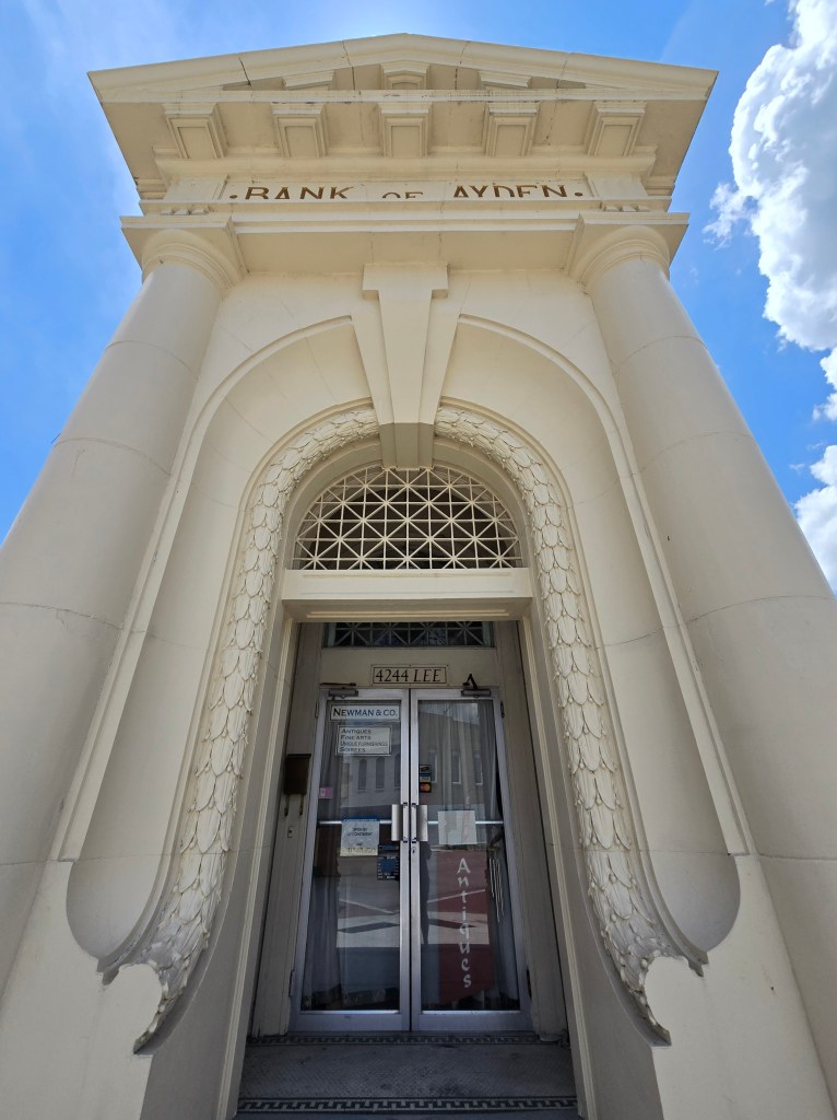
By the time of its incorporation on January 24, 1893, Ahoskie had grown to include several stores, a saw mill and gin, a one-room school, and a Baptist church. Other industries that flourished in the town’s early days included an ice plant, a laundry operated by a wandering Chinese man, and a number of horse and mule exchanges and sales stables. Since few of the smaller towns in Hertford and Bertie counties were located on passenger lines, traveling salesman or “drummers” would use the town as a base to make sales trips to outlying community stores by horse and buggy. The town’s first bank, the Bank of Ahoskie, was chartered in 1905. This area’s economy was initially based on the cultivation of tobacco and cotton. It has continued to be largely rural with small towns.
The county gave an acre of land on which the first Black school in Ahoskie was built, three years after the Civil War. The first Black church, The New Ahoskie Baptist Church, was organized in 1866. Other early churches in the Black community were The Methodist Church and Calvary Baptist Church. By 1939, the town had grown to include a number of Black-owned businesses including five grocery stores, three barber shops, three cafes, a dry goods store, a millinery shop, three hairdressers, three seamstresses, a doctor, a stenographer, two funeral homes, and a garage.
More fun facts…
Perhaps the largest show seen in the town was a visit by Buffalo Bill’s Wild West Show in October 1916, an event that drew an estimated 12,000 people and required three shows to accommodate everybody.
Electric lights were first turned on in Ahoskie around Christmas in 1915 with power generated by a gasoline engine. Within two years, electricity was available both day and night.
Ahoskie was the first stop in North Carolina for first lady Ladybird Johnson during her whistle-stop tour of the South aboard the Lady Bird Express, on October 6, 1964.
Graham Smith, one of the Tuskegee Airman, is from this area.
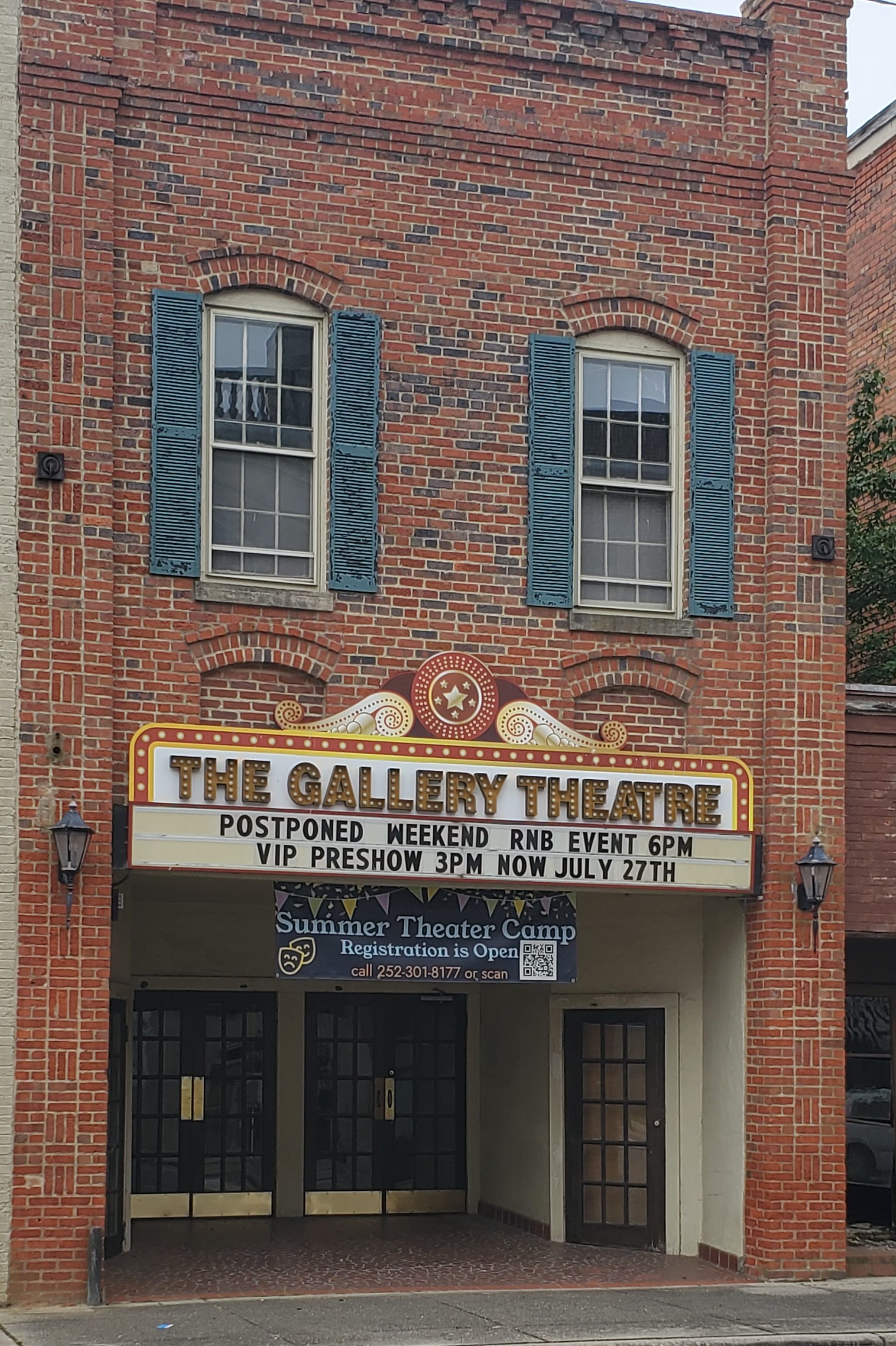
Gallery Theatre
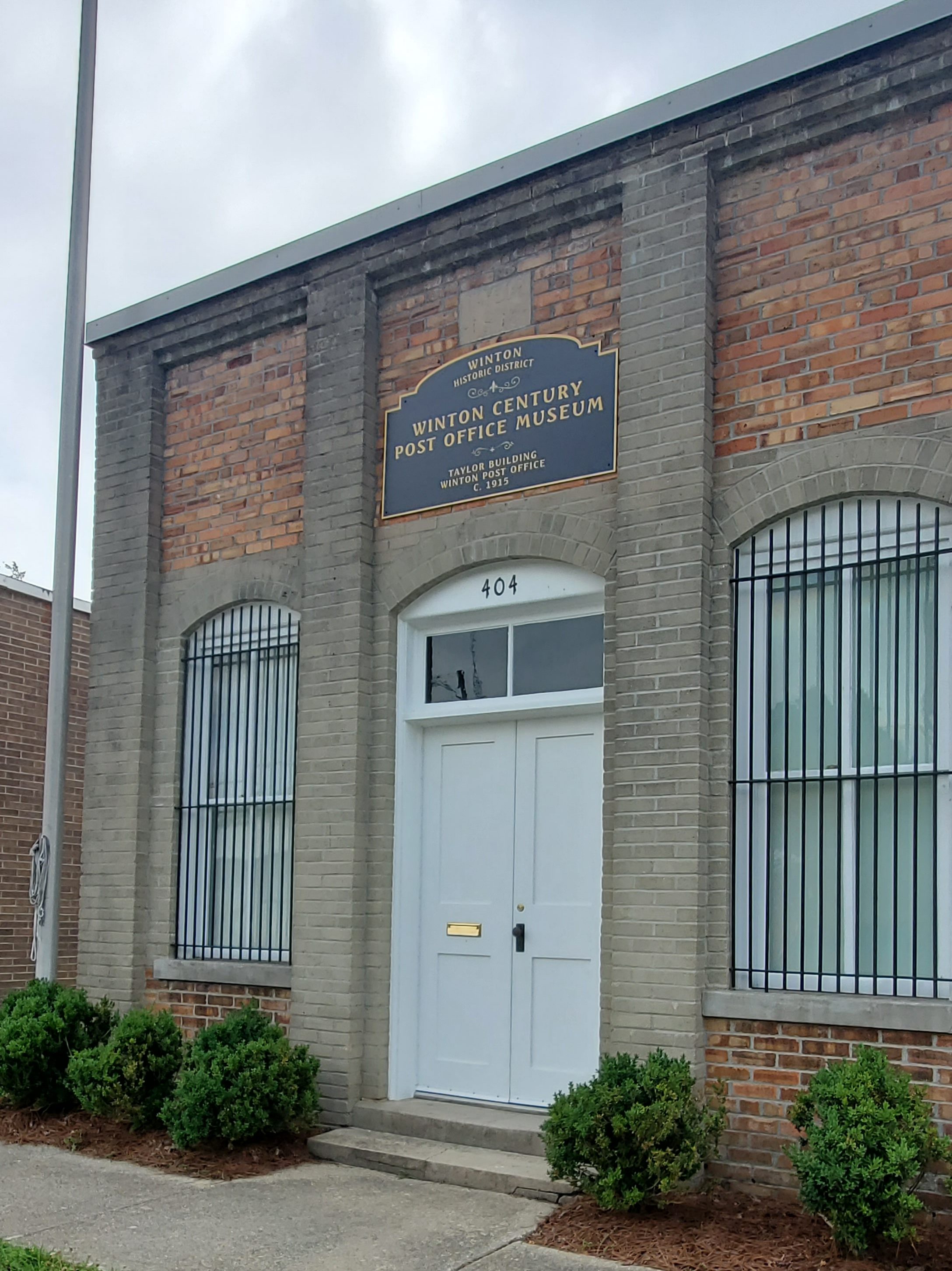
Winton
Winton was established and has been the county seat of Hertford County since 1766. On September 19, 1862, Union soldiers under Colonel Rush C. Hawkins sacked and burned the town. The earliest buildings in the Winton Historic District reflect the Italianate, Queen Anne, and Gothic Revival styles of the mid-to-late nineteenth century. In 1924, Winton was connected south to Ahoskie by the Winton-Ahoskie Highway, now US Highway 13, and a steel highway bridge was built across the Chowan River at Winton in 1925, the first in the county to cross the river. Thad Eure, a politician who holds the record for longest tenure as an elected official in the United States, serving as North Carolina Secretary of State from 1936 to 1989, is from the area.
Murfreesboro
The first recorded inhabitants of the Hertford County area were Native Americans from the Nottoway, Meherrin, and Chowanoke tribes. The first European known to visit the area was John White of the Roanoke Colony in the 16th century. It was also visited by an expedition from Jamestown, Virginia, in the 17th century. The last native inhabitants, the Chowanoke, were expelled after warring with the English in 1675 and 1676. After that, they were moved to a reservation east of the Chowan River in what is now Gates County.
The first known deed to property in the area is a land grant dated November 5, 1714, made to Henry Wheeler for a tract on the Meherrin River which included what is now Murfreesboro. On May 27, 1746, James Jordon Scott sold 150 acres on the Meherrin River (part of Wheeler’s original grant) to an Irish immigrant, William Murfree, from Virginia. On December 12, 1754, the General Assembly designated Murfree’s Landing as a King’s Landing, where imports and exports would be inspected by a representative of the King. The town was chartered by the General Assembly and renamed Murfreesboro on January 6, 1787. Murfreesboro was designated by the US Congress in 1790 as an official port of entry, and the customs records indicate a profitable three-cornered trade with New England and the West Indies.
In 1831 Murfreesboro was among towns that sent armed forces to Southampton County, Virginia, to quell Nat Turner’s slave rebellion. As a result of these events, Virginia and North Carolina reduced the rights of free blacks, prohibiting education of both free blacks and slaves.
William Hill Brown, author of the first American novel, is from the area.
Brady C. Jefcoat Museum The old Murfreesboro public school (which housed grades 1 – 12 until 1972) has been redeveloped as the Brady C. Jefcoat Museum (201 W High St.). It houses the collections of Brady Jefcoat, a Raleigh native, and includes hundreds of well-preserved ordinary items from the late 19th and early 20th century, including functional phonographs, radios, washing machines, washboards, and agricultural implements, as well as a wide variety of other novelties. The museum boasts several largest collections: washing machine equipment, butter churns, and irons.
Chowan University One University Place
Historic Murfreesboro includes several buildings and historic homes, including the Dr. Walter Reed House, B.B. Winborne Country Store and Law Office Museum (201 N 4th St), and Vincent-Deale Blacksmith Shop (202 N 4th St.) as well as others. Start at the Visitors Center on Main St. for a video presentation before you tour the properties and enjoy your step back in time!
Surrounded by the Roanoke and Meherrin Rivers, the Northampton County area was first organized under English colonial authority as the Albemarle Precinct. In 1729 part of Albemarle was split off to form Bertie County; then Northampton County was formed from part of Bertie in 1741. The county was named for James Compton, the fifth Earl of Northampton, England. Finally, in 1759, parts of Northampton County, Bertie County, and Chowan County were combined to form Hertford County.
Graysburg
Garysburg first appeared in official records as a post office named “Peeples Town” sometime between 1818 and 1825. “Peeples Town” or “Tavern” as it was also called, was located near the banks of the Roanoke River. Roderick B. Gary, a native of Halifax, NC, later settled in Northampton County and gave “Garysburgh” its name in 1838; and the spelling was officially changed to Garysburg in 1892. Gary became the operator of a hotel (now the Collier Place) and also served Northampton County as a state Representative.
During the 1840s, the original town’s site along the river was abandoned, and people began to settle in a nearby site just further north, which is now the present-day town of Garysburg. Situated between the railroad and the river, the town served as a major market for Northampton County and a point of interchange for commerce.
During the Civil War, Confederate troops established a camp just north of town and dug trenches near the river bridge to protect it from attack. The Methodist Episcopal Church (built upon land also donated by Gary) was converted into a hospital and used by Confederate soldiers from both North Carolina and Virginia, some of whom are buried in the church’s courtyard. Following the war, Garysburg remained prosperous.
NCCAR (North Carolina Center for Automotive Research) Situated at 310 Technology Drive, right beside a Lowe’s Home Improvement distribution center, you’ll find NCCAR, North Carolina’s own test raceway. Built and designed to exacting standards, the North Carolina Center for Automotive Research is an independent, nonprofit center devised to meet the ever-evolving product research, testing, and development demands of the automotive industry. State sponsorship and affiliation with North Carolina’s university and community college system offers exceptional opportunities for matching the innovative talents of the world’s automotive industry with the research capacity and business development resources of the State of North Carolina.
On-site, corporations and groups can also make use of their advanced chassis dynamics laboratory, plus client garages with virtual office connectivity, and a two-axle chassis dynamometer with climatic air handling and emissions.
The test track provides a 4.6-mile handling course, including dynamics areas with high-speed entry. The track is often used by NASCAR drivers, law enforcement training, prototype and vehicle testing, commercial shoots, and racing groups. The weekend of our visit, the track was hosting a women’s motorbike group.
Conway
Veterans Memorial Park Visit the county’s Veteran Memorial Park (Main St.), which displays a beautiful art mural. In Conway, you’ll also find one of Napolean Hills murals, which are located throughout the county.
Woodland When stopping in Woodland, be sure to see the Penny Beasley and Napolean Hill murals.
Rich Square
Quakers were some of the earliest settlers in Northampton County, being established there by the early 1750s. The congregation in Rich Square was established in 1760, and it was once a center for the Religious Society of Friends in North Carolina. By 1832, they were a minority in Rich Square, though they continued working to relocate former slaves into free states.
In 1947, Godwin Bush was a black man in Northampton County who escaped a lynching by a white mob; two all-white grand juries refused to indict the seven white kidnappers. In response, local pastor and businessman Paul A. Bishop promoted a black-led boycott of white-owned businesses in Rich Square (contemporaneously described by a black community leader as “a town that didn’t like black folk.”) Many of the boycotted stores went out of business.
Amazing Story: On July 26, 1959, Lieutenant Colonel William Rankin was flying his US Marine Corps F8U Crusader from Naval Air Station in South Weymouth, Massachusetts to the Naval Air Station in Beaufort, South Carolina. Rankin lost all power at an altitude of 47,000 feet when he ejected into the −70 °F air and began uncontrolled decompression through an intense thunderstorm and hail for the next 40 minutes. After “the most prolonged and fantastic parachute descent in history,” he landed near Rich Square, was rescued by a local farmer, and taken to Ahoskie, North Carolina for medical care. The plane crashed near Scotland Neck, North Carolina.
Miles Darden (1799–1857), supposedly the largest man in history, was from the area.
Lasker Singer, songwriter, and American Idol alumni Chris Daughtry, known as the lead vocalist and rhythm guitarist for the rock band Daughtry, is from Lasker.
Jackson
As the central city in Northampton County Jackson has it’s own claim to fame… Sir Archie. Thoroughbred Sir Archie (also known as Sir Archy), who died in 1833. Most racehorses foaled in America are related to him in some way. Among his descendants are Man O’War, Sea Biscuit, Native Dancer, Bold Ruler, Secretariat, Seattle Slew, Cigar, and Barbaro.
In Jackson, you’ll also find a series of Murals painted by Napolean Hill, including one of Sir Archie himself on one side of the Northampton County Museum.
Northampton County Museum While in Jackson, stop by the Northampton County Museum (203 West Jefferson St), just beside Lafayette Park, for a peak into the county’s history.
Discover Burlington at the heart of Alamance County!
The need of the North Carolina Railroad in the 1850s to locate land where they could build, repair and do maintenance on its track was the genesis of Burlington, North Carolina. The company selected a piece of land slightly west of present-day Graham. On January 29, 1856, the last spikes were driven into the final tie of the North Carolina Railroad project, uniting the cities of Goldsboro and Charlotte by rail. The next day, the first locomotive passed along the new route. When the iron horse arrived in Alamance County, locals referred to it as “the eighth wonder of the world”.
Not long after this historic opening, the railroad realized a pressing need for repair shops. With Alamance County’s position along the new line, it became the logical choice for the shops’ location. After several debates concerning where the shops would be located, Gen. Benjamin Trollinger, a progressive Alamance County manufacturer, made an offer that settled the matter. Gen. Trollinger owned land just northwest of Graham, and he convinced several other prominent citizens owning adjacent lots to join him and sell their property to the railroad. 57 buildings were constructed between 1855 and 1859, including structures for engine and machine shops, carpentry, blacksmithing, houses for workers and railway officials, and company headquarters. For a brief period, railroad directors changed the name of official name of “Company Shops” to “Vance” (1863–1864), the village returned to the “Company Shops” moniker in July 1864.
During the Civil War, Company Shops remained a small village without many public utilities or services, such as churches and schools. It was only in 1863 that company stockholders approved city street layouts and the sale of private property in the village, although properties used for commercial purposes still had to be leased by the company and couldn’t be bought. In 1866, the village was officially incorporated as “Company Shops.”
Through a series of leases and mergers, the railroad was leased to Richmond & Danville Railroad (1871), working as part of the Pennsylvania Railroad, and in 1893, the North Carolina Railroad was folded into the Southern Railway system. With the railroad shops no longer operated there, the citizens of Company Shops decided a new name was needed. In February 1887, a contest was held to decide a name, and one person submitted the name “Burlington” after seeing it on a passing train. An appointed committee for the town selected the name, and the name was officially changed through North Carolina State Legislature.
Around the turn of the century, Edwin M. Holt established small textile operations along the Haw River and Great Alamance Creek. In 1908, Edwin M. Holt built the first cotton mill in the South. From the establishment of this single factory, Alamance County grew to eventually operate 30 cotton mills and 10 to 15 yarn manufacturing plants employing 15,000 people. Eventually, the early textile venture of Edwin M. Holt became known all over the world as Burlington Industries. Throughout this period, Burlington became a prosperous and vibrant small city filled with schools, churches, newspapers, telegraph and telephone lines, roads and a streetcar line.
During a century-and-a-half of economic change, Burlington grew, adapted, and prospered. Originally the center of commerce for Company Shops, the downtown area still serves as the heart of today’s community with financial services, government services, an expanded library, small shops, eateries and a restored theater. Downtown has also returned to its status as a major employment center, becoming the home to Laboratory Corporation of America (LabCorp), one of the world’s largest biomedical testing firms and Burlington/Alamance County’s largest employer.
Dentzel Carousel at Burlington City Park One of Burlington’s prized destinations is the carousel at Burlington City Park (1388 S Main St.). The grounds consist of many outdoor activities and play spaces, walking paths, a mini train ride, and, or course, the beautiful indoor, 3-row carousel. This carousel has been restored and well cared for over the years and the building’s doors open to the outdoors during temperate days, while being heated and air conditioned inside when needed. The carousel operates during select hours on weekends.
Burlington Historic District While in downtown, be sure to meander through the historic district, which includes a variety of shops, a bookstore (Persnickety Books), ice cream shop, the 1928 Paramount Theater (128 East Front St.) and public art. Adjacent to the shopping areas is the old rail station complete with a few rail cars on display and statuary on the grounds. Stop by Zack’s Hot Dogs (201 W Davis St.) for some local fare too!
BONUS: While in downtown Burlington, you can head out on a scavenger hunt for various murals, including “Dance It Out,” the “Burlington Mural,” “Justice & Equality,” “Locks of Love: Heart of Downtown Burlington,” and “Between Us,” plus public art installations at Alamance Arts, New Leaf Society, and more.
Alamance County was formed on January 29, 1849 from Orange County. Alamance County was named after Great Alamance Creek, the site of the Battle of Alamance (May 16, 1771), a pre-Revolutionary War battle in which militia under the command of Governor William Tryon crushed the Regulator movement. Great Alamance Creek, and Little Alamance Creek, according to legend, were named after a local Native American word to describe the blue mud found at the bottom of the creeks. Other legends say the name came from another local Native American word meaning “noisy river,” or for the Alamanni region of Rhineland, Germany, where many of the early settlers came from.
During the American Revolution, several small battles and skirmishes occurred in the area that became Alamance County. Several occurred during the lead-up to the Battle of Guilford Court House, including Pyle’s Massacre, the Battle of Lindley’s Mill, and the Battle of Clapp’s Mill.
In the 1780s, the Occaneechi Native Americans returned to North Carolina from Virginia, settling in what is now Alamance County rather than their first location near Hillsborough. In 2002, the modern Occaneechi tribe bought 25 acres of their ancestral land in Alamance County and began a Homeland Preservation Project that includes a village reconstructed as it would have been in 1701 and a 1930s farming village.
During the early 19th century, the textile industry grew heavily in the area, so the need for better transportation grew. By the 1840s, several mills were set up along the Haw River and near Great Alamance Creek as well as other major tributaries of the Haw River. Between 1832 and 1880, at least 14 major mills were powered by these rivers and streams. Mills were built by the Trollinger, Holt, Newlin, Swepson, and Rosenthal families, among others. One of the mills, built in 1832 by Ben Trollinger, is still in operation. It is owned by Copland Industries, sits in the unincorporated community of Carolina, and is the oldest continuously operating mill in North Carolina.
One notable textile produced in the area was the “Alamance plaids” or “Glencoe plaids” used in everything from clothing to tablecloths. The Alamance Plaids manufactured by textile pioneer Edwin M. Holt were the first colored cotton goods produced on power looms in the South, and paved the way for the region’s textile boom. (Holt’s former home is now the Alamance County Historical Society.) By the late 20th century, most of the plants and mills had gone out of business, including the mills operated by the once great Burlington Industries, a company based in Burlington. By the 1840s, the textile industry was booming, and the railroad was being built through the area as a convenient link between Raleigh and Greensboro.
North Carolina actually seceded from the union after a special legislative session in which North Carolina’s legislature unanimously voted for secession on May 20, 1861.
No battles took place in Alamance County, but it sent its share of soldiers to the front lines. In July 1861, for the first time in American history, soldiers were sent in to combat by rail. By the end of the war, 236 people from Alamance County had been killed in the course of the war, more than any other war since the county’s founding.
Alamance County was also once the state leader in dairy production. Several dairies including Melville Dairy in Burlington were headquartered in the county. With increasing real estate prices and a slump in milk prices, most dairy farms have been sold and many of them developed for real estate purposes.
According to a 1975 study of the history of post offices in North Carolina by Treasure Index, Alamance County has 27 ghost towns that existed in the 18th and 19th centuries. Additionally, five other post offices no longer exist. These towns and their post offices were either abandoned as organized settlements or absorbed into the larger communities that now make up Alamance County.
Blanche Taylor Moore, convicted murderer, whose life story was portrayed in the television movie “Black Widow: The Blanche Taylor Moore Story,” starring Elizabeth Montgomery, was from the area.
Elon
Elon began in 1881 as a North Carolina Railroad depot in between the stations of Goldsboro and Charlotte, called “Mill Point” because it was envisioned to be a shipping point for area cotton mills. Locals called it “Boone’s Crossing.” Because of a growing population, a post office was built, which established a more permanent residency in 1888.
In 1889, the local Christian Assembly created an institution of higher learning called the “Graham Normal College”. The founders of Elon College named the school “Elon”, because they understood that to be the Hebrew word for oak, and the area contained many oak trees. The town was called “Elon College” until the college known as Elon College became Elon University. The town then changed its name officially to Elon.
Elon University Elon College (100 Campus Dr.) was founded by the Christian Connection, which later became a part of the United Church of Christ. The charter for Elon College was issued by the North Carolina legislature in 1889. William S. Long was the first president, and the original student body consisted of 76 students. In 1923, a fire destroyed most of the campus, including school records, classrooms, the library, and the chapel. The board of trustees voted to rebuild immediately. Many of the buildings that were erected in the years following the fire still stand and make up the bedrock of Elon’s campus.
An institution that for many years enrolled mostly North Carolina residents, Elon began to enroll significant numbers of students from the mid-Atlantic states in the mid-1970s, and began to improve its academic standards for admission. By the start of the 21st century, about 68 percent of Elon’s students came from out-of-state and were only accepted if they met high academic standards. Elon became known as a selective university and, by 2013, 82% of incoming students were from out of state. Elon’s transformation was the subject of an academic study by George Keller of the University of Pennsylvania titled Transforming a College: The Story of a Little Known College’s Strategic Climb to National Distinction. The study, published by Johns Hopkins University Press, depicted how Elon transformed itself from a regional religious college to a selective, nationally recognized university.
Elon is no longer affiliated with the United Church of Christ. Elon’s mission statement states that the university “embraces its founders’ vision of an academic community that transforms mind, body, and spirit and encourages freedom of thought and liberty of conscience”, and emphasizes its commitment to “nurture a rich intellectual community characterized by student engagement with a faculty dedicated to excellent teaching and scholarly accomplishment.”
Glen Raven
Glen Raven is a census-designated place (CDP) in Alamance County and is part of the Burlington Metropolitan Statistical Area. The area of current Glen Raven was once occupied by Altamahaw-Ossipee Native American people. A fabric manufacturer by the name of John Quinten Gant used the land as the headquarters of present-day Glen Raven Fabrics. Glen Raven Fabrics created the fabric used to make the first American flag that was planted on the moon. Sunbrella is their flagship brand.
Glencoe
Glencoe is an unincorporated community in Alamance County located on the Haw River. Glencoe is also home to Textile Mill Town and Textile Heritage Museum. The Glencoe Mill Village Historic District and Glencoe School are listed on the National Register of Historic Places.
Textile Heritage Museum Peruse through the Textile Heritage Museum (2406 Glencoe St, Burlington) for a peek back into the past. Then head to the mill keeper’s home across the street to see two restored rooms in period furniture and decor.
Glencoe Mill Village The old mill homes along Glencoe St. take up 3 surrounding streets. Workers were given a roof over their heads but were not allowed to buy their homes. This, combined with low wages and long work days, led mill workers to strike in the 1880s
Today, you can walk through the colorful old mill houses, which are mostly occupied and have been kept up. Listed on the National Register of Historic Places, the Glencoe Cotton Mill complex consists of the mill production facilities, the Company Store and Administrative offices of the mill president (the Textile Heritage Museum), a barber shop (private residence), Baptist Church (active), and individually restored houses owned by private residents. The village was built between 1880 and 1882 on 105 acres of land along the river. Glencoe was developed and managed by James H. Holt, son of textile pioneer, Edwin M. Holt, who would become one of the most influential textile entrepreneurs of the South throughout the nineteenth century.
Millworkers’ produced plaid cotton flannel material, which was shipped to finishing mills all over the United States. Historical interpretive markers are positioned throughout the Glencoe Village for visitors to learn more about the people who lived and worked in Glencoe during its prosperity. You’ll also find hiking trails, kayak and canoe accesses, picnic areas, and public fishing along the Haw River. A variety of companies currently reside within the mill complex.
In the 1970s, the mill was sold to Glen Raven Mills, which still owns it to this day. Though the mill is gone many of the mill houses have remained.
Ace Speedway Ace Speedway (3401 Altamahaw Racetrack Rd)is a 4/10-mile oval stock car racing track. Originally constructed by Roy Maddren and opened in 1956 as a 1/3-mile dirt oval, the track was expanded in 1984 to a 3/8-mile dirt oval. In 1990, the track was paved and became part of the NASCAR Wintson Cup banner. In 1999, the track was re-expanded to a 4/10-mile paved oval and the pits were expanded as well.
Mebane
Mebane is a city located mostly in Alamance County, North Carolina, United States, and partly in Orange County. The town was named for Alexander Mebane, an American Revolutionary War general and member of the U.S. Congress. It was incorporated as “Mebanesville” in 1881, and in 1883 the name was changed to “Mebane”. It was incorporated as a city in 1987. In October 2014, the city council voted to adopt a new seal and slogan, replacing “A progressive community, the perfect place to call home” with “Positively Charming”. The Annual Dogwood Festival is help in April each year.
Tanger Outlet Shop to your heart’s content at Tanger Outlet (4000 Arrowhead Blvd, Mebane).
Swepsonville
Swepsonville was named for the builder of a mill on the western side of town. Swepson disappeared one night with a considerable amount of money and soon established a mill in the North. The old mill, unused for many years, burned down in 1989 in a ten-alarm fire which brought firetrucks from all surrounding counties, was visible from the freeway 3 miles away, and made the national news.
Haw River
Haw River was officially incorporated on June 1, 1973. In 1745, Adam Trollinger established a homestead on the banks of the Haw River. From that beginning, the community of Haw River was developed. Trollinger was a native of the Rhine River valley in Germany and had lived in Pennsylvania before heading south to seek a new life. His settlement was very near the site of an earlier Sissipahaw Indian village. Trollinger chose the spot because it had an easy crossing while nearby the river moved with enough power to drive a mill wheel.
In 1748, Adam’s son, Jacob, built a grist mill, one of the first industries in the wilderness area. A village known as Trollinger’s Ford grew up around the mill.
Lord Cornwallis passed nearby during the last days of the Revolutionary War. His foraging soldiers raided Trollinger’s Mill and confiscated the miller’s grain. When Jacob confronted the redcoats, they bound him to a tree with a bridle bit in his mouth. Upon his release, Trollinger sent two of his sons and a slave to help fight the British.
Benjamin Trollinger built the first part of the Granite Mill in 1844, marking the beginning of the textile industry in the village. It is the only antebellum mill building in Alamance County still in use. In 1849, the North Carolina Railroad was chartered and Benjamin Trollinger secured its passage through the mill town by building a railroad bridge over the river at his own expense. The town became known as Haw River Depot. Benjamin Trollinger also was instrumental in locating the railroad repair station at Company Shops (now Burlington) a few miles west. The railroad bridge was the scene of derailments in 1911, 1936, and 1960. The last wreck damaged the depot which led to its demolition.
In 1928, the cotton factories in Haw River were acquired by Proximity Manufacturing, which later became Cone Mills Corporation. When corduroy became popular, the company decided to produce the cloth in Haw River. The plants south of Main Street were renamed Tabardrey and were equipped with new machinery to produce corduroy. The mills north of the highway became Granite Finishing for the finishing of the cloth. Corduroy production began on May 1, 1930, and Granite was shipping finished goods by June of the same year.
The little town thrived in the years following World War II. Businesses flourished on Main Street in the 1950s, and the Cone plants became the largest producers of corduroy in the world, employing over 1,000 people in 1981.
Graham
Graham was laid out in 1849 as the county seat of the newly formed Alamance County, and was incorporated as a town in 1851; it became a city in 1961. It was named for William Alexander Graham, U.S. senator from North Carolina (1840–1843) and governor of North Carolina (1845–1849).
The lynching of Wyatt Outlaw, the first African-American Town Commissioner and Constable of Graham, on February 26, 1870, by the Ku Klux Klan, along with the assassination of State Senator John W. Stephens at the Caswell County Courthouse, provoked Governor William Woods Holden to declare martial law in Alamance and Caswell Counties, resulting in the Kirk-Holden War of 1870.
Sesquicentennial Park
In downtown Graham, you’ll find Sesquicentennial Park, a small gazebo-like park at the North West corner of Court Square.
Alamance Arts 213 S Main St, Graham
Graham Historical Museum 135 W Elm St
Alamance Children’s Museum 217 S Main St, Graham
Saxapahaw
Saxapahaw, like most communities in Alamance County, was a mill town built around the community’s cotton mill along the Haw River. The first mill was built in the community in 1844 by Quaker settler John Newlin, but was later demolished to make way for a brick structure. The current mill building was owned and operated by Dixie Yarns until 1994, when a tornado damaged the structure and operations never resumed. Building remodeling was completed in 2006 and the facility, now known as Rivermill, houses apartments and a restaurant. The Haw River Ballroom is a music venue set in the former Dye House of Saxapahaw’s historic cotton mill. The Former Saxapahaw Spinning Mill and James Monroe Thompson House are listed on the National Register of Historic Places.
Saxapahaw Island Park This cute little riverside park (5550 Church Rd) is tucked away just opposite the Rivermill and restaurants, immediately on the other side of the bridge. It’s just a short walk from the parking lot to this wooded playground and unique play structure.
Eli Whitney
Eli Whitney gained its name from the inventor of the cotton gin, Eli Whitney. The reasoning for this was because there was once a cotton gin located in the community, but has been gone for many years now. Eli Whitney was once home to a school as well, but it too closed and was later demolished. The school’s gymnasium was left standing and now serves as a community center.
Liberty Acres Liberty Acres (8790 Sylvan Rd.) is an animal conservation park and equine rescue. Plus, they have an extensive exotic bird breeding station. There’s always a variety of animals here, from zebras and horses to foxes, wallabies, reptiles, turkeys, parrots, exotic birds, and much more!
Snow Camp
The origin of the name of the community is disputed, but the most commonly accepted story as to how the name came about was that before the American Revolution a group of hunters from Pennsylvania camped there during a snowfall. The lesser accepted story is that General Cornwallis camped there during a snowfall around the time of the Battle of Guilford Court House.
Though quite small, Snow Camp is historically significant. Herman Husband, a leader in the Regulator Movement lived here. The Regulator Movement culminated in the Battle of Alamance prior to the Revolutionary War. During the Revolutionary War, battles were fought nearby at Lindley’s Mill, Clapp’s Mill, and at Pyle’s Defeat.
Snow Camp was also a site of early Quaker settlement in North Carolina, as Friends from Pennsylvania migrated to the Cane Creek valley in the mid-1700s and established the Spring Meeting at Snow Camp; several historic buildings clustered around the spring remain from that settlement.
Today the Snow Camp Outdoor Theater (301 Drama Rd) is popular for outdoor theater throughout the summer.
Cedar Rock Park At Cedar Rock Park (4242 R Dean Coleman Rd), you can stroll through an array of old buildings, a well, an old schoolhouse bell, and more — plus, friendly goats and sheep too.
Alamance
Alamance was the site of the largest conflict of the War of the Regulation on May 16, 1771. Governor William Tryon’s decisive victory over a force of 2,000 Regulators effectively ended the war (Battle of Alamance). The region around Alamance was also the site of a defeat of British Loyalists in the American Revolutionary War in a skirmish known as Pyle’s Massacre on February 25, 1781. The name is said to have been given by German settlers, from the Native American word ‘allamanca.’
Alamance Battleground Alamance Battleground (5803 NC-62 South) is a must-stop for history and war buffs. The site marks where the Battle of Alamance ended the War of Regulation on May 16, 1771. The site includes a visitors center, a log home, monuments, site markers, a cemetery, and walking trails.
The first inhabitants of the area eventually comprising Montgomery County were Keyauwee and Cheraw Native Americans. And the first European settlers were German and Scottish.
Montgomery County was created in 1779 out of Anson County. It was named in honor of Richard Montgomery, an American Revolutionary War general killed in 1775 while attempting to capture Quebec City, Canada. The law establishing the county also directed a group of commissioners to secure land near the center of the county for the construction of a country courthouse and prison. Many residents were dissatisfied with the location chosen, and after several years of demurring on a decision, a courthouse was erected in the community of Henderson, created at the confluence of the Yadkin and Uwharrie rivers in 1794. In 1816, the old courthouse was sold another was erected at the new community of Laurenceville. In 1841, the portion of Montgomery County west of the Yadkin/Pee Dee River became Stanly County. Two years later, commissioners were selected to move the courthouse to Montgomery’s geographic center, and in 1844 Troy was established as the county seat.
The county’s first paved roads were established in the 1920s. The Great Depression, which began in 1929, had a large adverse impact on the local agricultural and manufacturing industries. By 1933, 30 percent of local residents were unemployed.
Beulah Clark Parsons Davis (born October 31, 1896 in Montgomery County and lived until January 3, 1948 in Durham, North Carolina) was a well-known fortune-telling witch, who lived during the Great Depression. She was interviewed by Omar Darrow as part of the North Carolina Federal Writers’s Project housed at the University of North Carolina Southern History Collection, which was a New Deal program created to document the regional and local history of North Carolina during the Great Depression.
Ether
Ether Roller Mill, a site that tax records place as being built in 1800. This has been used as a local spooky attraction. The building has lost integrity since 2017 when it was left to the elements. A post office (across the street) has been in operation since 1888. The community was named for ether, a drug once prescribed by a local physician.
Star
Star is known as the geographic center of North Carolina as measured via satellite, according to the Army Corps of Engineers. A plaque marking the exact center was placed at 35°23′59″N 79°46′00″W (35.399756, -79.766613). The plaque is on private land and not open to visitors. However, conflicting reports show the geographic center actually being in Chatham County, northwest of Sanford.
The town of Star was incorporated in 1897. It was originally called Hunsucker’s Store, after a trading post operated by the original landowner, Mr. Martin Hunsucker. After the Civil War, a man named Angus Leach moved to Hunsucker’s Store and helped to found the present Town of Star, serving as postmaster, hotel operator, and general merchandise store owner. Gold was discovered in the area around 1866, and by 1874 there were extensive gold mining operations in this part of the state, particularly around the Little River area of Star. When the Aberdeen and West End Railroad (owned by the Page family of Aberdeen, NC), completed a branch to Star from Filo, NC (Biscoe, North Carolina) in 1895, it was only a short period later before Star was incorporated into a town.
Star was a major shipping point for lumber, turpentine, and bricks beginning in 1896 with the completion of the Asheboro and Montgomery Railroad, also built by the Page family. In 1896, the Leach Family erected a large wooden hotel to accommodate the travelers and workers of the railroad, and the hotel (The Star Hotel Bed and Breakfast) is still standing today and is owned by Gary Spivey. In 1897, the Aberdeen and West End Railroad merged with the Asheboro and Montgomery Railroad to form the Aberdeen and Asheboro Railroad, thus opening the area to a whole new range of shipping. The timber industry was the first major factor in the growth of Star. The Star Lumber Company, headed by Z.T. Wright, J.B. Shamburger, and W.T. Harper, had built a tramway in 1896 to haul logs to the mills in town. The tramway was removed in 1901 when the Durham and Charlotte Railroad was built to Star.
Around 1900, a bottling plant was established in Star by J.R. Ingrahm to bottle sodas for the area. This company preceded the Coca-Cola Plant in Star, which was later moved to Biscoe, North Carolina. Also in 1900, the Montgomery Roller Mill was incorporated with a capital stock of $4,700 by Braxton Auman, who also operated a whiskey distillery and chair factory. In 1907, Star’s first undertaker, Mr. H.D. Phillips, established a funeral parlor. This was the beginning of a long and successful business for the Phillips family who still operate the Phillips Funeral Home today.
The town saw massive growth between 1912 and 1950 when the Norfolk Southern Railway purchased the old lines of the Aberdeen and Asheboro Railroad and the Durham and Charlotte Railroad. The operation held a depot, water tank, and coal chute in Star. This new era saw the introduction of the hosiery mill industry, a boom in lumber production, various new stores and products, and a huge surge in population. In 1914–1915, Boy Scout Troop 111 was established in Star, one of the earliest in North Carolina. Since that point, the town continued to slowly grow into a prosperous community.
In the 1960s, the town undertook the task of erecting some of the first public housing units in the state. On March 14, 1969, Lancer Inc., one of the nation’s top 50 upholstered furniture manufacturers, started its operations in Star and continues to be one of Star’s largest employers, having expanded its operations six times. Since then, the hosiery mills experienced a decline and eventually left Star. This left hundreds unemployed, and the once prosperous town of Star began to wither away. The buildings that once employed many now mostly sit empty. In September 2013, downtown Star was honored by being listed on the National Register of Historic Places as the Star Historic District.
Today, Star has been designated as a U.S. Postal Service Christmas Town. The Star Christmas Parade is documented as one of the oldest in the State, as well as the longest with the most entries. Central Park NC has its current headquarters in the old Country Life Academy building in Star, now known as STARworks Center for Creative Enterprise. STARworks hosts several annual events including the Annual Glass Pumpkin Patch and FireFest: Community Fueled Art. The town is located at the center of the state of North Carolina. Local and nearby attractions include Uwharrie National Forest, Badin Lake, Lake Tillery, North Carolina Zoo, and Pinehurst.
StarWorks Located at 100 Russell Drive along the railroad tracks as you enter Star, StarWorks [a 501(c)(3) nonprofit that hosts, ceramic, metal, and glass artist residencies and internships] is a large gallery showcasing art in many forms, especially glass. All items, small and large, are available for purchase. They have a School House Gallery, StarWorks Ceramics, and a Cafe & Tap Room. In addition to their regular hours, the gallery hosts several sales and events throughout the years, including at the holidays. They place a high priority on K-12 education, including field trips, classes, demonstrations, and independent studies. 2023 events included GlassFest, FireFest, Hot Glass Cold Beer, Glass Pumpkin Patch, and Holiday Market.
Biscoe
The town is named after Henry Biscoe, an important customer of the local lumber business. The area was formerly called “Filo,” before the current name was adopted in 1895. Biscoe’s past was dependent on the railroad industry, and it was once an important repair center for railroad equipment. The Aberdeen and West End Railroad (owned by the Page family of Aberdeen, North Carolina) completed a branch to Star, North Carolina from Filo, NC (current Biscoe) in 1895. The A & W. E. R.R. was merged into the Aberdeen and Asheboro Railroad in 1897. Biscoe was incorporated in 1901.
Candor
Candor is the home of the North Carolina Peach Festival, which is held every year on the third Saturday of July. The town’s welcome sign reads: Welcome to Candor. Peach Capital. Candor was so named for the settlers’ honest dealings.
Mt. Gilead
This region was occupied by the Pee Dee culture, part of the Southern Appalachian Mississippian culture, from about 980 to 1150. They built the earthwork platform mound and other structures at Town Creek Indian Mound, which has been designated a National Historic Landmark since 1966. It is the only Native American site in the state to be designated as a national landmark. In the 21st century, the Pee Dee are based in South Carolina, where the state has recognized several bands as tribes.
Mount Gilead was incorporated in 1899 as the textile industry built mills in the Piedmont section of the state. They processed the commodity crop of cotton, which had been important to the South since before the Civil War. The textile mills provided jobs to white residents of the region, later also employing blacks and supporting relative prosperity in the region. Since the late 20th century, many textile jobs moved offshore in a restructuring of the industry as it sought lower labor costs. Like many small southern towns, Mount Gilead suffered economic and population decline following the loss of these textile jobs.
The town’s Historic District was listed on the National Register of Historic Places in 2005. Mount Gilead was selected to participate in the N.C. Small Town Main Street Program (co-sponsored by the National Trust for Historic Preservation) and received a S.T.E.P. (Small Town Economic Prosperity) grant of $220,000 to help revitalize the downtown area and create jobs.
Most buildings in town were built late-nineteenth and early-twentieth century. Mount Gilead had an abundance of timber, clay, stone, and slate to provide for any sort of construction that was needed or desired by owners and builders. Several structures incorporate local sandstone used in door and window sills and lintels.
Mount Gilead Museum
The Mount Gilead Museum is located in a restored 18850Victorian house near the downtown area, that belonged to the McAulay family, who played an important role in Mount Gilead business, church, social, and civic life. The museum houses many documents, photographs, and historic artifacts that tell the story of Mount Gilead’s past. (Open only Sundays by appointment)
Town Creek Indian Mound Town Creek Indian Mound is a prehistoric Native American archaeological site located near Mount Gilead. The site, whose main features are a platform mound with a surrounding village and wooden defensive palisade, was built by the Pee Dee, a South Appalachian Mississippian culture people. They thrived in the Pee Dee River region of North and South Carolina during the Pre-Columbian era. The Town Creek site was an important ceremonial site occupied from about 1150—1400 CE. It was abandoned for unknown reasons. It is the only ceremonial mound and village center of the Pee Dee located within North Carolina.
The Pee Dee people shared the Mississippian culture that was characterized in part by building large, earthwork mounds for spiritual and political purposes. They participated in a widespread network of trading that stretched from Georgia through South Carolina, eastern Tennessee, and the mountain and Piedmont regions of North Carolina. The Town Creek site is not large by Mississippian standards. The earthwork mound was built over the remains of a rectangular-shaped earth lodge. The site was declared a National Historic Landmark on October 15, 1966.
The site is the only national historic landmark in North Carolina to commemorate American Indian culture. It is owned by the North Carolina Department of Natural and Cultural Resources and is operated by the Division of State Historic Sites. Today the Pee Dee people are based in South Carolina, where the state has recognized four bands and one group.
The state has developed several facilities at Town Creek Indian Mound (509 Town Creek Mound Rd.) that are open to the public. It built a reconstructed ceremonial center, restoring the platform mound and reconstructing a temple on it. It also reconstructed a minor temple and the mortuary. The visitor center houses interpretive exhibits, audiovisual programs, and a gift shop. The visitor center, minor temple, and mortuary are handicapped accessible. Several trails and outdoor monuments are located on the property. Fourteen picnic tables are located on the grounds
Pee Dee
The community was named for the Pee Dee people, who built the nearby Town Creek Indian Mound.
Troy
Troy lies in an area once known for its vast longleaf pine forests. Much of the town’s early development came from the harvesting of those trees for lumber and turpentine. Originally known as West Old Fields, the name was changed to Troy in 1843 when the county seat of Montgomery County was moved there from Old Lawrenceville. The town was incorporated in 1853.
The coming of the Asheboro and Aberdeen railroad as well as the gold mining industry surrounding the town accelerated growth in the late 19th century. By the 20th century textile mills and lumber mills were contributing heavily to Troy’s economy. The Hotel Troy, Montgomery County Courthouse, and Troy Residential Historic District are listed on the National Register of Historic Places.
This newly constructed amphitheater is located at 225 Smitherman Street within the Capel Centennial Park. The Town of Troy holds free concerts at the TownStage from April through October, and movie nights are held here during the summer months of June, July, and August.
TroyFest is the Town of Troy’s annual Independence Day Celebration with daytime and evening events. Daytime activities include a parade, music, family entertainment, kid games and rides, and vendors. The evening extravaganza includes music, family entertainment, and vendors, plus a fireworks display at the Park.
Capel Rug Outlet
In Candor, you’ll find the Capel Rug Outlet, showcasing high-quality rugs by the well-known brand in many styles and price points — from smaller 18″ x 36″ rugs to the super large 18-foot rugs.
Uwharrie Mercantile Located on the ground floor of the old Hotel Troy (401 N. Main St.), Uwharrie Mercantile serves up lunch during the week and coffee every day, plus you can shop through their dry goods and gifts for yourself or someone else, including some work by local artists. Definitely stop here while in town and stroll through the other local shops as well.
Okeewemee
In the early 19th century, small schools had sprung up in Montgomery County. One of those was the Forks of Little River School, later called Crossroads. By 1891, the school had assumed the name of Okeewemee in honor of the community and its first Post Office which had it start in the home of Elizabeth Coggins and John L. Allen.
The Carter Mine is one of the oldest mines in North Carolina. It is described as being on a vein that contained much lime carbonate and a rare telluride of gold. The mine is said to have produced $100,000 or more from workings less than 100 ft. deep. Gold-bearing quartz was found in a vein that averaged 3 ft. in width and contained some very rich steaks. Rock found on the dumps in 1934 included “sugar” vein quartz.
Eldorado
Eldorado Outpost The Eldorado Outpost (4021 NC Hwy 109N) is frequented by hunters, fishers, hikers, and others visiting the nearby Uwharrie Forest, known for a few Big Foot/Sasquatch sightings. You’ll find most anything you’ll need for the day here, along with Big Foot merchandise too.
Ophir
Ophir is located in the heart of the Uwharrie National Forest in the Uwharrie Mountains. There are numerous campgrounds and hiking trails, hunting and fishing spots, and recreational services nearby for the outdoorsman’s comfort. Badin Lake and Lake Tillery are only a few miles away, and the Uwharrie River runs through it.
Ophir was named after Ophir, the biblical region where gold was produced for King Solomon’s temple. The small community was settled during the mid-19th century, during the gold boom in the state of North Carolina. Very little mining was done in Montgomery County during the Civil War. Manpower was short. Men were away at war and those left at home were focused on taking care of the farms and their families. In 1891, there were 35 mines in operation in the county, but a short while later in 1896, the NC Geographical Survey named only 18 mines in use. In the northwest corner of the county there were many regional mines, including several in the Ophir area. These mines all had a major impact and played important roles in the county’s mining history.
The Russell Mine, one of the larger producers in Montgomery County, had a total production of around 15,000 ounces of lode gold. This mine included several open pits and underground workings that attained a depth of over 200 feet. The largest pit, “Big Cut”, is about 300 feet long, 150 feet wide, and 60 feet deep. As a whole, material excavated from this pit is said to have averaged $2.00 to the ton in gold. The entire mass is gold-bearing but only certain parts of it are rich enough to work, and even these parts are of low grade except for rich seams that appear and disappear abruptly.
The Steel Mine is located just west of Ophir along the Uwharrie River. It was a lode gold mine. Gold is said to have been discovered here about 1832, and the mine appears to have been worked extensively before 1853. Someone said that at this mine, gold digging amounted to mania for farmers were locating gold in almost every hill. The only year for which production data are available is 1887, when $150,000 (about 75,000 ounces) in gold was produced. In 1876 the property was purchased by an English company, and until 1884 the ore was treated in Chilean mills. Today, the Steel Mine is nearly inaccessible and the 1832 structures are in total ruins.